
Forest ecosystems are regarded as the soul of Earth and makes up 31% of world’s biodiversity. Conservation and sustainability of forests ecosystem is immensely important as the forests foster other ecosystems by providing services like clean air, purified water and acting as a sink to carbon dioxide etc. So, it is very important to monitor and map the changes in these forests. UAV technology brought about a game changing platform for monitoring, managing and protecting forests from calamities and human interventions. The monitoring and observance of forests especially those primordial forests found in hilly terrain can pose to be a tiresome and exhaustive process in a sense that requires an abundant amount of workforce and skills, along with appropriate resources.
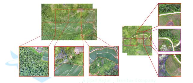
Accounting to be a major challenge of forestry, surveillance of forests is done to ensure the prevention of the dangerous undertakings that lead to greater hazards to nature. In cases of forest fires, illegal felling of trees, etc., it becomes difficult for the forest managers and workers to take immediate action owing to the large span of areas that constitutes forests. Unmanned Aerial Vehicles (UAVs), also known as Drones help in terms of aerial surveillance, mapping, aerial photography, thermal and hyperspectral imagery, and topographic monitoring. Subsequently, this aids in wildlife conservation, biodiversity and vegetation conservation, the balance of ecology, and similar aspects of forestry. Drones associated with GarudaUAV are equipped with various sensors such as LiDAR and hyperspectral helps not only in monitoring the forests but also to measure the forest carbon stocks, species as well as forest loss during calamities. The high-resolution data can be collected flexibly in a short time with daily monitoring and at a relatively low price. Also, drones have an important role in filling the gaps of common data collected using manned aircraft or satellite remote sensing, while having many advantages both in research and in various practical applications particularly in forestry as well as in land use in general.
Interestingly, GarudaUAV is filling these gaps in promising ways as we have worked with various partners and delivered them their products with customer satisfaction. Hyperspectral drones associated with GarudaUAV have capabilities to derive 3D hyperspectral information from lightweight snapshot sensors on board of UAVs for vegetation monitoring based on a structure from motion approach that results in a digital surface model (DSM) as a representation of the 3D space linked to objects’ reflectance. We are working with authorities in monitoring forest fires and this is one of the boons of using thermal as well as hyperspectral drones as this help to analyze the temperature and fuel load (by calculating water content in the tree using hyperspectral sensors) in the forests resulting into mapping of vulnerability as well as resilience of the forests up to a great precision. Accounting for a major part of the forest ecosystem, animals, insects, and birds are also endangered by the harm that forest fires cause. Under their influences, GarudaUAV aims to relieve these dangers and perils through their LiDAR sensors-based drones. AI and ML based drones which are available with us have potential to detect and prevent tree diseases using Hyperspectral and LiDAR sensors that help accumulate and process data attributed to the wellbeing of trees, vegetation, and bushlands. Thermal imagery, topographic surveying, aerial mapping help locate diseased flora and navigate horticulturists and forest officials towards improving their conditions. Apart from these main roles, our company is working on forest management activities, wildlife movement monitoring and management, vegetation canopy height and terrain estimation, forest biomass estimation, planning and monitoring of forest plantations and restorations, monitoring and alarming illegal felling of forests and surveilling deforestation etc. In near future, we are going to expand our capabilities that will help to cover a large range of forestry fields, such as forest dynamics, species detection, forest disturbance evaluation and others, all these with a quick implementation requirement in the variety of situations that occur in the sustainable management of forests.
great points altogether, you just received a brand new reader. What might you recommend about your post that you simply made a few days ago? Any positive?
An additional issue is really that video gaming has become one of the all-time biggest forms of entertainment for people of various age groups. Kids participate in video games, plus adults do, too. Your XBox 360 is probably the favorite video games systems for many who love to have a lot of video games available to them, plus who like to play live with other folks all over the world. Many thanks for sharing your ideas.
I truly wanted to make a quick word to appreciate you for these marvelous tips and tricks you are giving out at this site. My time intensive internet lookup has finally been paid with useful ideas to talk about with my contacts. I would mention that most of us readers are unquestionably blessed to live in a very good website with many marvellous people with valuable tricks. I feel pretty grateful to have come across your webpages and look forward to tons of more amazing minutes reading here. Thank you once again for everything.
I will immediately clutch your rss as I can’t to find your e-mail subscription link or newsletter service. Do you have any? Please let me know so that I could subscribe. Thanks.
I do agree with all of the ideas you’ve presented in your post. They’re really convincing and will certainly work. Still, the posts are too short for starters. Could you please extend them a little from next time? Thanks for the post.
A person necessarily lend a hand to make seriously posts I would state. That is the first time I frequented your website page and to this point? I amazed with the research you made to make this actual submit amazing. Wonderful activity!
A person essentially lend a hand to make critically posts I’d state. This is the first time I frequented your website page and up to now? I surprised with the analysis you made to create this particular post incredible. Great job!
Good post however I was wanting to know if you could write a litte more on this subject? I’d be very grateful if you could elaborate a little bit further. Thank you!
Hi, i think that i noticed you visited my blog thus i got here to 搟go back the desire?I am trying to to find things to enhance my site!I assume its adequate to use a few of your ideas!!
s9vako02
Please let me know if you’re looking for a author for your weblog. You have some really great posts and I think I would be a good asset. If you ever want to take some of the load off, I’d love to write some material for your blog in exchange for a link back to mine. Please blast me an e-mail if interested. Regards!
MUinpWhBTdKQbH
axb dolls セックスドール胸の代替ガイド2020年のセックスドールの新しいパターンあなたはあなたの子供をオルガスムにさせることができますか?Racyme監査–Racyme.comレビュー
Somebody essentially help to make seriously posts I would state. This is the very first time I frequented your website page and thus far? I amazed with the research you made to make this particular publish amazing. Excellent job!
I was curious if you ever thought of changing the layout of your site? Its very well written; I love what youve got to say. But maybe you could a little more in the way of content so people could connect with it better. Youve got an awful lot of text for only having one or 2 pictures. Maybe you could space it out better?
I was recommended this blog by my cousin. I’m not sure whether this post is written by him as nobody else know such detailed about my difficulty. You are incredible! Thanks!
Hello! Someone in my Myspace group shared this site with us so I came to check it out. I’m definitely enjoying the information. I’m bookmarking and will be tweeting this to my followers! Outstanding blog and outstanding style and design.
Hello, Neat post. There is an issue with your website in web explorer, would test this?IE nonetheless is the market chief and a big part of other folks will pass over your great writing because of this problem.
My partner and I stumbled over here by a different web address and thought I may as well check things out. I like what I see so i am just following you. Look forward to looking at your web page yet again.
You made a number of good points there. I did a search on the subject matter and found nearly all folks will go along with with your blog.
Thanks for this informative blog. It was packed with information and delivered great insights. If you’re keen on viral real estate SEO, don’t hesitate to explore https://www.elevenviral.com to learn more.
Many thanks for the insightful post. It’s been packed with information , and offered valuable knowledge. If you’re interested in how to boost your real estate business online, be sure to check out https://www.elevenviral.com for more information.
I have discovered some significant things through your site post. One other point I would like to talk about is that there are plenty of games that you can buy which are designed particularly for toddler age kids. They include pattern acknowledgement, colors, wildlife, and patterns. These generally focus on familiarization instead of memorization. This keeps a child occupied without having the experience like they are studying. Thanks
Hi there! Do you use Twitter? I’d like to follow you if that would be okay. I’m undoubtedly enjoying your blog and look forward to new posts.
I appreciate, cause I found exactly what I was looking for. You have ended my 4 day long hunt! God Bless you man. Have a great day. Bye
I have been checking out a few of your stories and i can claim clever stuff. I will make sure to bookmark your site.
Thanks for your helpful article. Other thing is that mesothelioma is generally the result of the breathing of dust from asbestos fiber, which is a carcinogenic material. It truly is commonly found among staff in the construction industry that have long contact with asbestos. It’s also caused by moving into asbestos covered buildings for a long period of time, Genetics plays a crucial role, and some consumers are more vulnerable to the risk in comparison with others.
I do believe all of the concepts you have presented in your post. They’re very convincing and will definitely work. Still, the posts are too short for newbies. May just you please prolong them a bit from next time? Thank you for the post.
I do agree with all of the ideas you’ve presented in your post. They’re really convincing and will certainly work. Still, the posts are very short for novices. Could you please extend them a bit from next time? Thanks for the post.
Thanks for your useful article. One other problem is that mesothelioma cancer is generally attributable to the inhalation of fibres from mesothelioma, which is a positivelly dangerous material. It really is commonly viewed among workers in the building industry who’ve long experience of asbestos. It’s also caused by moving into asbestos protected buildings for a long time of time, Genetic makeup plays an important role, and some individuals are more vulnerable towards the risk as compared to others.
I think this is among the most important information for me. And i’m glad reading your article. But wanna remark on some general things, The website style is ideal, the articles is really great : D. Good job, cheers
Very nice post. I just stumbled upon your weblog and wanted to say that I have really enjoyed surfing around your blog posts. After all I抣l be subscribing to your feed and I hope you write again soon!
I used to be more than happy to seek out this internet-site.I wished to thanks in your time for this wonderful learn!! I undoubtedly enjoying every little little bit of it and I have you bookmarked to check out new stuff you weblog post.
Excellent beat ! I would like to apprentice while you amend your site, how could i subscribe for a blog site? The account aided me a acceptable deal. I had been tiny bit acquainted of this your broadcast provided bright clear idea
I抣l right away grab your rss feed as I can not find your e-mail subscription link or newsletter service. Do you’ve any? Kindly let me know in order that I could subscribe. Thanks.
medicine in mexico pharmacies: cmq mexican pharmacy online – buying prescription drugs in mexico online
mexican border pharmacies shipping to usa
https://cmqpharma.com/# purple pharmacy mexico price list
mexican rx online
It抯 really a cool and helpful piece of information. I am satisfied that you shared this helpful information with us. Please stay us up to date like this. Thanks for sharing.
I like this weblog it’s a master piece! Glad I
found this ohttps://69v.topn google.Blog range
mexico drug stores pharmacies: mexican pharmacy – medication from mexico pharmacy
mexico drug stores pharmacies
https://cmqpharma.com/# medicine in mexico pharmacies
mexico drug stores pharmacies
Thanks for your helpful article. Other thing is that mesothelioma cancer is generally brought on by the breathing of fibers from mesothelioma, which is a extremely dangerous material. It’s commonly noticed among laborers in the engineering industry who have long experience of asbestos. It can be caused by residing in asbestos covered buildings for an extended time of time, Your age plays a crucial role, and some individuals are more vulnerable for the risk when compared with others.
pharmacy canadian superstore: best rated canadian pharmacy – online canadian pharmacy reviews
canadian pharmacy ltd: canadian pharmacy – canadian discount pharmacy
https://canadapharmast.com/# legit canadian pharmacy online
buying prescription drugs in mexico mexico pharmacy reputable mexican pharmacies online
indian pharmacies safe online pharmacy india world pharmacy india
mexican drugstore online: buying prescription drugs in mexico – best online pharmacies in mexico
https://foruspharma.com/# mexican mail order pharmacies
mail order pharmacy india buy prescription drugs from india п»їlegitimate online pharmacies india
canadianpharmacy com: canadian pharmacy in canada – canadapharmacyonline legit
http://indiapharmast.com/# best india pharmacy
mail order pharmacy india buy medicines online in india mail order pharmacy india
mexican online pharmacies prescription drugs: buying prescription drugs in mexico online – buying from online mexican pharmacy
indian pharmacy: Online medicine home delivery – india pharmacy
indianpharmacy com: india pharmacy – top 10 pharmacies in india
http://indiapharmast.com/# indian pharmacy online
mexico pharmacy: mexican border pharmacies shipping to usa – pharmacies in mexico that ship to usa
mail order pharmacy india: pharmacy website india – indian pharmacy online
indian pharmacy online: buy medicines online in india – Online medicine order
https://foruspharma.com/# mexican online pharmacies prescription drugs
top 10 pharmacies in india india online pharmacy indian pharmacy paypal
canadian pharmacy antibiotics: canadian discount pharmacy – pharmacy in canada
top 10 online pharmacy in india indian pharmacies safe best online pharmacy india
77 canadian pharmacy: pet meds without vet prescription canada – cheap canadian pharmacy online
mexican pharmaceuticals online: purple pharmacy mexico price list – best online pharmacies in mexico
canadian online pharmacy: canadian online pharmacy – buy prescription drugs from canada cheap
http://foruspharma.com/# п»їbest mexican online pharmacies
indian pharmacy Online medicine order reputable indian pharmacies
https://canadapharmast.com/# onlinepharmaciescanada com
http://clomiddelivery.pro/# can you buy generic clomid without prescription
http://clomiddelivery.pro/# where can i get cheap clomid for sale
doxycycline india pharmacy doxycycline 500mg capsules doxycycline 100 mg india
price of amoxicillin without insurance: where can i buy amoxocillin – buy amoxicillin online mexico
http://amoxildelivery.pro/# amoxicillin 500mg capsules price
doxycyline doxycycline 100mg tablets doxycycline 100mg online uk
cheapest doxycycline tablets: doxycycline 100 mg tablets – doxycycline uk
http://ciprodelivery.pro/# buy ciprofloxacin over the counter
https://doxycyclinedelivery.pro/# order doxycycline online canada
doxycycline 20 mg tablets: doxycycline 125 mg – doxycycline 75 mg capsules
http://doxycyclinedelivery.pro/# buy doxycycline 100mg
where can i buy amoxicillin over the counter amoxicillin 1000 mg capsule amoxicillin generic brand
paxlovid pharmacy: paxlovid buy – paxlovid for sale
https://clomiddelivery.pro/# how to get clomid pills
cheap clomid now where buy clomid prices get cheap clomid pills
ciprofloxacin generic: ciprofloxacin 500mg buy online – ciprofloxacin over the counter
https://doxycyclinedelivery.pro/# can you buy doxycycline over the counter in india
http://ciprodelivery.pro/# ciprofloxacin
http://doxycyclinedelivery.pro/# doxycycline otc
cipro ciprofloxacin ciprofloxacin order online ciprofloxacin mail online
where can i buy clomid without insurance: buying clomid for sale – get generic clomid no prescription
https://ciprodelivery.pro/# ciprofloxacin
paxlovid generic paxlovid generic paxlovid covid
purchase cipro: buy cipro without rx – buy cipro
where can i get clomid pill: cheap clomid pills – can you buy clomid without dr prescription
http://amoxildelivery.pro/# amoxicillin 800 mg price
http://ciprodelivery.pro/# ciprofloxacin generic
http://paxloviddelivery.pro/# paxlovid pharmacy
ciprofloxacin ciprofloxacin mail online ciprofloxacin over the counter
paxlovid cost without insurance: buy paxlovid online – paxlovid price
https://paxloviddelivery.pro/# paxlovid price
amoxicillin 500 mg without prescription generic amoxil 500 mg amoxicillin medicine
https://paxloviddelivery.pro/# paxlovid buy
Paxlovid buy online: paxlovid pill – paxlovid for sale
https://paxloviddelivery.pro/# paxlovid price
doxycycline 200 mg pill: buy doxycycline online cheap – doxycycline generic pharmacy
https://clomiddelivery.pro/# can i purchase generic clomid
best price for prescription doxycycline doxycycline 100g doxycycline cream over the counter
http://clomiddelivery.pro/# cost clomid no prescription
clomid sale: where to buy cheap clomid tablets – how to get cheap clomid
http://paxloviddelivery.pro/# Paxlovid buy online
amoxicillin discount coupon amoxicillin 500mg capsule cost where can i buy amoxicillin over the counter uk
amoxicillin 500 mg purchase without prescription: buy amoxicillin canada – cheap amoxicillin 500mg
http://doxycyclinedelivery.pro/# best price for doxycycline
https://doxycyclinedelivery.pro/# buy doxycycline 100mg cheap
buy cipro online canada: ciprofloxacin – where can i buy cipro online
https://ciprodelivery.pro/# cipro online no prescription in the usa
where can i get cheap clomid without a prescription can i get generic clomid buying clomid for sale
paxlovid generic: paxlovid pill – paxlovid covid
https://amoxildelivery.pro/# amoxicillin online pharmacy
https://paxloviddelivery.pro/# paxlovid pill
https://doxycyclinedelivery.pro/# doxycycline 100mg price in south africa
buy cipro ciprofloxacin over the counter buy cipro online without prescription
paxlovid for sale: paxlovid india – paxlovid india
http://doxycyclinedelivery.pro/# where to buy doxycycline over the counter
doxycycline buy online us: doxycycline 20 mg tablets – doxycycline buy online us
https://clomiddelivery.pro/# where can i get clomid without rx
amoxicillin 500mg cost: amoxicillin 500mg prescription – amoxicillin without rx
doxycycline online canada: how to buy doxycycline online – doxycycline medication pills
mexican border pharmacies shipping to usa pharmacies in mexico that ship to usa mexican rx online
mexico pharmacies prescription drugs: pharmacies in mexico that ship to usa – mexican mail order pharmacies
mexican pharmaceuticals online: reputable mexican pharmacies online – п»їbest mexican online pharmacies
http://mexicandeliverypharma.com/# mexican rx online
buying prescription drugs in mexico п»їbest mexican online pharmacies mexican rx online
reputable mexican pharmacies online: mexican pharmaceuticals online – mexico pharmacies prescription drugs
pharmacies in mexico that ship to usa: п»їbest mexican online pharmacies – buying from online mexican pharmacy
http://mexicandeliverypharma.com/# pharmacies in mexico that ship to usa
pharmacies in mexico that ship to usa mexican drugstore online mexico pharmacies prescription drugs
mexican drugstore online: buying prescription drugs in mexico online – buying from online mexican pharmacy
mexican online pharmacies prescription drugs mexican border pharmacies shipping to usa medication from mexico pharmacy
best online pharmacies in mexico: mexican border pharmacies shipping to usa – medicine in mexico pharmacies
https://mexicandeliverypharma.com/# mexican pharmaceuticals online
mexican online pharmacies prescription drugs: mexico drug stores pharmacies – buying prescription drugs in mexico
reputable mexican pharmacies online: medicine in mexico pharmacies – pharmacies in mexico that ship to usa
mexican pharmacy mexican mail order pharmacies mexican pharmaceuticals online
mexico drug stores pharmacies: mexican pharmaceuticals online – mexican online pharmacies prescription drugs
mexican pharmaceuticals online: mexico drug stores pharmacies – mexican drugstore online
best online pharmacies in mexico: mexican drugstore online – buying from online mexican pharmacy
best online pharmacies in mexico mexican rx online medicine in mexico pharmacies
best online pharmacies in mexico: medicine in mexico pharmacies – mexican pharmaceuticals online
п»їbest mexican online pharmacies mexican pharmaceuticals online mexico drug stores pharmacies
mexican pharmaceuticals online: best online pharmacies in mexico – mexican pharmaceuticals online
pharmacies in mexico that ship to usa: mexican border pharmacies shipping to usa – mexican drugstore online
reputable mexican pharmacies online: reputable mexican pharmacies online – medication from mexico pharmacy
mexican mail order pharmacies buying from online mexican pharmacy mexican online pharmacies prescription drugs
reputable mexican pharmacies online: medication from mexico pharmacy – buying prescription drugs in mexico
mexico drug stores pharmacies: mexican pharmaceuticals online – medicine in mexico pharmacies
mexican border pharmacies shipping to usa: mexican online pharmacies prescription drugs – reputable mexican pharmacies online
Thank you for your sharing. I am worried that I lack creative ideas. It is your article that makes me full of hope. Thank you. But, I have a question, can you help me?
purple pharmacy mexico price list mexican online pharmacies prescription drugs mexican drugstore online
mexico drug stores pharmacies: п»їbest mexican online pharmacies – pharmacies in mexico that ship to usa
reputable mexican pharmacies online: mexican mail order pharmacies – buying prescription drugs in mexico
reputable mexican pharmacies online: mexican border pharmacies shipping to usa – mexican pharmaceuticals online
mexican border pharmacies shipping to usa: mexican drugstore online – buying prescription drugs in mexico online
best online pharmacies in mexico: mexican border pharmacies shipping to usa – mexico drug stores pharmacies
buying from online mexican pharmacy pharmacies in mexico that ship to usa best online pharmacies in mexico
mexican pharmaceuticals online: reputable mexican pharmacies online – purple pharmacy mexico price list
best online pharmacies in mexico: mexico drug stores pharmacies – pharmacies in mexico that ship to usa
buying prescription drugs in mexico: buying prescription drugs in mexico – buying prescription drugs in mexico online
buying prescription drugs in mexico online mexican mail order pharmacies mexican rx online
mexican pharmaceuticals online: mexican online pharmacies prescription drugs – buying from online mexican pharmacy
purple pharmacy mexico price list: best online pharmacies in mexico – mexican mail order pharmacies
mexican online pharmacies prescription drugs: п»їbest mexican online pharmacies – medicine in mexico pharmacies
buying from online mexican pharmacy pharmacies in mexico that ship to usa mexican border pharmacies shipping to usa
mexican rx online: medication from mexico pharmacy – mexican rx online
mexico drug stores pharmacies: buying prescription drugs in mexico – best online pharmacies in mexico
buying prescription drugs in mexico online mexican pharmaceuticals online п»їbest mexican online pharmacies
mexican pharmaceuticals online: buying prescription drugs in mexico – mexican border pharmacies shipping to usa
mexican drugstore online: pharmacies in mexico that ship to usa – mexico drug stores pharmacies
п»їbest mexican online pharmacies: purple pharmacy mexico price list – mexico drug stores pharmacies
buying prescription drugs in mexico п»їbest mexican online pharmacies medicine in mexico pharmacies
mexico drug stores pharmacies: п»їbest mexican online pharmacies – mexico drug stores pharmacies
mexico pharmacies prescription drugs: reputable mexican pharmacies online – mexico pharmacies prescription drugs
buying prescription drugs in mexico: best online pharmacies in mexico – buying prescription drugs in mexico
buying prescription drugs in mexico mexican pharmaceuticals online medication from mexico pharmacy
mexican border pharmacies shipping to usa: reputable mexican pharmacies online – mexico drug stores pharmacies
mexican rx online: mexican drugstore online – п»їbest mexican online pharmacies
buying from online mexican pharmacy medicine in mexico pharmacies mexican border pharmacies shipping to usa
best online pharmacies in mexico: mexico pharmacies prescription drugs – medicine in mexico pharmacies
mexican pharmaceuticals online: mexico drug stores pharmacies – mexican rx online
п»їbest mexican online pharmacies: mexican pharmaceuticals online – mexican online pharmacies prescription drugs
mexican border pharmacies shipping to usa buying prescription drugs in mexico medication from mexico pharmacy
mexican drugstore online: pharmacies in mexico that ship to usa – mexico drug stores pharmacies
mexican mail order pharmacies: buying prescription drugs in mexico online – buying from online mexican pharmacy
mexico drug stores pharmacies: reputable mexican pharmacies online – best online pharmacies in mexico
buy cheap generic zithromax: zithromax azithromycin – zithromax 1000 mg pills
http://nolvadexbestprice.pro/# should i take tamoxifen
home generic propecia home
nolvadex for pct how to prevent hair loss while on tamoxifen does tamoxifen cause joint pain
buy zithromax online cheap: zithromax online paypal – buy cheap generic zithromax
http://cytotecbestprice.pro/# cytotec online
http://propeciabestprice.pro/# buying cheap propecia no prescription
order cheap propecia without insurance get propecia without a prescription cost propecia without insurance
cytotec online: п»їcytotec pills online – purchase cytotec
https://nolvadexbestprice.pro/# tamoxifen and uterine thickening
http://prednisonebestprice.pro/# prednisone 60 mg daily
tamoxifen breast cancer prevention how does tamoxifen work cost of tamoxifen
tamoxifen adverse effects: tamoxifen lawsuit – alternatives to tamoxifen
http://prednisonebestprice.pro/# prednisone 5 mg tablet price
cytotec buy online usa: cytotec buy online usa – buy cytotec online
zithromax capsules price: zithromax tablets – zithromax buy online
cytotec pills buy online: Cytotec 200mcg price – buy cytotec online fast delivery
cost propecia price: buy propecia pill – buying generic propecia tablets
Your point of view caught my eye and was very interesting. Thanks. I have a question for you.
https://cytotecbestprice.pro/# cytotec abortion pill
prednisone 50 mg tablet canada: cost of prednisone 5mg tablets – buy prednisone online from canada
cost generic propecia without prescription: buying cheap propecia without prescription – cost of propecia tablets
https://cytotecbestprice.pro/# purchase cytotec
aromatase inhibitor tamoxifen: arimidex vs tamoxifen bodybuilding – tamoxifen for breast cancer prevention
migliori farmacie online 2024: Avanafil prezzo – Farmacie online sicure
miglior sito dove acquistare viagra: viagra online – viagra naturale in farmacia senza ricetta
https://kamagrait.pro/# farmacia online
Farmacia online piГ№ conveniente avanafil senza ricetta migliori farmacie online 2024
acquistare farmaci senza ricetta: Cialis generico 20 mg 8 compresse prezzo – farmaci senza ricetta elenco
Farmacie online sicure: Farmacia online migliore – farmacie online sicure
http://cialisgenerico.life/# comprare farmaci online con ricetta
Farmacia online piГ№ conveniente Cialis generico 5 mg prezzo farmacia online piГ№ conveniente
farmacia online senza ricetta: avanafil senza ricetta – acquistare farmaci senza ricetta
Farmacie on line spedizione gratuita: avanafil generico – farmacia online
farmacia senza ricetta recensioni kamagra senza ricetta in farmacia or cialis farmacia senza ricetta
http://nwcod.com/forum/away.php?s=https://viagragenerico.site/ viagra cosa serve
pillole per erezione immediata viagra online spedizione gratuita and gel per erezione in farmacia viagra online consegna rapida
https://kamagrait.pro/# comprare farmaci online all’estero
cialis farmacia senza ricetta: viagra online – viagra originale in 24 ore contrassegno
alternativa al viagra senza ricetta in farmacia: viagra online siti sicuri – farmacia senza ricetta recensioni
http://avanafil.pro/# farmacie online sicure
top farmacia online Cialis generico prezzo farmacie online autorizzate elenco
viagra originale in 24 ore contrassegno: viagra online – viagra online in 2 giorni
farmacia online piГ№ conveniente: kamagra – farmaci senza ricetta elenco
farmacie online autorizzate elenco Farmacie online sicure or top farmacia online
http://www.country-retreats.com/cgi-bin/redirectpaid.cgi?URL=kamagrait.pro/ farmaci senza ricetta elenco
Farmacia online miglior prezzo farmacia online senza ricetta and migliori farmacie online 2024 Farmacia online miglior prezzo
http://cialisgenerico.life/# Farmacie online sicure
farmaci senza ricetta elenco: avanafil 100 mg prezzo – migliori farmacie online 2024
viagra originale in 24 ore contrassegno viagra generico in farmacia costo or viagra originale recensioni
http://www.google.dj/url?sa=t&rct=j&q=&esrc=s&source=web&cd=3&cad=rja&uact=8&ved=0cd0qfjac&url=https://viagragenerico.site/ kamagra senza ricetta in farmacia
viagra generico in farmacia costo viagra naturale and le migliori pillole per l’erezione viagra consegna in 24 ore pagamento alla consegna
Farmacie online sicure top farmacia online or Farmacie on line spedizione gratuita
https://australianmodern.com.au/?URL=http://farmait.store comprare farmaci online all’estero
farmacia online senza ricetta п»їFarmacia online migliore and farmacie online affidabili farmacia online senza ricetta
cialis free trial coupon: cheapest tadalafil – cialis tablets
cialis online without prescription: order generic cialis by phone – shop cialis
http://sildenafil.llc/# cheap viagra
cialis nex day delivery uk cialis without a doctor prescription cialis american express
https://sildenafil.llc/# how long does viagra last
https://tadalafil.auction/# buy cialis pay with paypal canada
viagra price buy sildenafil online usa buy viagra generic
viagra canada: buy sildenafil online canada – viagra without a doctor prescription usa
http://tadalafil.auction/# where to buy cialis in australia
100 mg viagra lowest price: Viagra without a doctor prescription – canadian viagra
cost of viagra: Cheap generic Viagra – viagra from canada
http://tadalafil.auction/# find cialis online
buy viagra buy sildenafil online usa real viagra without a doctor prescription
buy cialis: cialis pay with paypal – cialis soft
https://sildenafil.llc/# viagra generic
cheap generic cialis canada cialis vs viagra reviews cialis without a perscription
viagra without a doctor prescription usa viagra vs cialis or online viagra
https://images.google.com.vn/url?q=https://sildenafil.llc viagra from canada
buy viagra professional viagra price and viagra without doctor prescription generic viagra overnight
https://tadalafil.auction/# cialis over the counter in spain
cialis express delivery australia cialis without a doctor prescription cialis price comparison
natural viagra: Viagra online price – free viagra
buy viagra pills over the counter alternative to viagra or viagra without doctor prescription
http://adamlewisschroeder.com/info.php?a=<a+href=https://sildenafil.llc:: buy viagra online without a prescription
buy generic viagra online viagra from canada and how does viagra work buy viagra order
cialis vs viagra: Cheap Viagra online – buy viagra pills
http://sildenafil.llc/# viagra dosage
cialis and viagra: cialis without a doctor prescription – whats better viagra or cialis
https://sildenafil.llc/# buy viagra order
order cialis canada cheapest tadalafil cialis generic
australia cialis on line cialis dapoxetine europe or online buy cialis
http://anonim.co.ro/?http://tadalafil.auction generic cialis 20mg
cialis overnight generic cialis overnight delivery and cheap online cialis google south africa cialis
best ed pills online: Best ED meds online – affordable ed medication
https://edpillpharmacy.store/# low cost ed medication
cheapest ed pills
http://mexicopharmacy.win/# mexican drugstore online
pharmacy website india: Top mail order pharmacies – cheapest online pharmacy india
https://indiapharmacy.shop/# indianpharmacy com
indian pharmacy online Online pharmacy USA reputable indian online pharmacy
Online medicine order: Online pharmacy USA – world pharmacy india
http://mexicopharmacy.win/# mexican mail order pharmacies
medication from mexico pharmacy: Mexico pharmacy online – mexican pharmaceuticals online
http://edpillpharmacy.store/# cheap boner pills
cheapest ed treatment
best india pharmacy: Online medicine home delivery – buy medicines online in india
https://edpillpharmacy.store/# ed pills cheap
http://mexicopharmacy.win/# medicine in mexico pharmacies
online ed drugs
mail order pharmacy india: Online India pharmacy – indian pharmacies safe
Great job on this post!
cheap ed drugs: Best ED meds online – ed meds cheap
http://mexicopharmacy.win/# mexican online pharmacies prescription drugs
online prescription for ed: ed pills online – ed medicines online
http://indiapharmacy.shop/# indian pharmacies safe
reputable indian pharmacies Online pharmacy india pharmacy mail order
purple pharmacy mexico price list: mexico pharmacy win – п»їbest mexican online pharmacies
http://indiapharmacy.shop/# top 10 pharmacies in india
I love how you’ve broken down this topic into easy-to-understand sections. The step-by-step approach you’ve taken is very helpful.
online pharmacy india: indian pharmacy – world pharmacy india
http://edpillpharmacy.store/# erectile dysfunction medications online
best ed pills online: ed online prescription – get ed meds online
ed medication online cheap ed meds online or ed medications online
https://www.goodbusinesscomm.com/siteverify.php?ref=stp&site=edpillpharmacy.store/collections/somnuz-mattress::: low cost ed meds online
pills for ed online cheapest online ed treatment and online ed drugs get ed meds online
how to get ed pills cheap ed medication or online ed drugs
https://maps.google.iq/url?q=https://edpillpharmacy.store erectile dysfunction meds online
ed meds cheap cheap erectile dysfunction pills and ed doctor online order ed pills
online shopping pharmacy india: Best Indian pharmacy – buy prescription drugs from india
http://indiapharmacy.shop/# world pharmacy india
world pharmacy india Online India pharmacy top online pharmacy india
This is such a valuable resource. I’ve learned so much from this post, and I appreciate the practical advice you’ve shared.
where can i buy ed pills: Cheapest online ED treatment – cheapest erectile dysfunction pills
reputable mexican pharmacies online pharmacies in mexico that ship to usa or medicine in mexico pharmacies
https://images.google.sk/url?q=http://mexicopharmacy.win mexican border pharmacies shipping to usa
mexican rx online buying prescription drugs in mexico and mexican pharmaceuticals online mexican drugstore online
http://indiapharmacy.shop/# india pharmacy
mail order pharmacy india indian pharmacy online or india pharmacy mail order
https://lozd.com/index.php?url=http://indiapharmacy.shop pharmacy website india
pharmacy website india best india pharmacy and indianpharmacy com india online pharmacy
buy prescription drugs from india: Top mail order pharmacies – Online medicine order
http://edpillpharmacy.store/# ed pills
Your tips are always on point.
best online pharmacy india: Top online pharmacy in India – indian pharmacy
cheapest ed treatment: ed pills online – buy ed pills online
http://edpillpharmacy.store/# best ed pills online
https://mexicopharmacy.win/# purple pharmacy mexico price list
erectile dysfunction pills online pills for erectile dysfunction online or what is the cheapest ed medication
https://image.google.ps/url?q=https://edpillpharmacy.store ed online prescription
low cost ed medication ed med online and pills for ed online ed treatments online
mexican pharmaceuticals online: Purple pharmacy online ordering – buying prescription drugs in mexico online
low cost ed meds: Best ED pills non prescription – buy ed pills online
http://indiapharmacy.shop/# buy prescription drugs from india
online shopping pharmacy india Online India pharmacy cheapest online pharmacy india
best india pharmacy: Indian pharmacy online – cheapest online pharmacy india
http://indiapharmacy.shop/# world pharmacy india
how to get ed pills: Cheap ED pills online – cheapest ed meds
https://mexicopharmacy.win/# п»їbest mexican online pharmacies
indian pharmacies safe: Online medicine home delivery – indian pharmacy
ed medications cost online ed pills or cheap ed pills
http://www.gensuikin.org/i/index.cgi?id=1&mode=redirect&no=242&ref_eid=110&url=http://edpillpharmacy.store ed pills for sale
online ed pharmacy ed meds online and ed online pharmacy buy erectile dysfunction pills
We have helped many people who love to play online casinos, this is not a scam promise.
https://main7.top/baca/
mexican drugstore online: mexican pharmacy – buying from online mexican pharmacy
https://mexicopharmacy.win/# purple pharmacy mexico price list
online pharmacy india buy prescription drugs from india india online pharmacy
erectile dysfunction online prescription: Best ED pills non prescription – cheapest ed treatment
http://edpillpharmacy.store/# online ed drugs
cheap ed pills: online ed prescription same-day – order ed meds online
where to buy ed pills edmeds or ed prescription online
http://noexcuselist.com/li/?url=http://edpillpharmacy.store cheap erectile dysfunction pills
where to get ed pills buy erectile dysfunction pills and best ed pills online erectile dysfunction drugs online
mexican pharmaceuticals online: Purple pharmacy online ordering – pharmacies in mexico that ship to usa
http://mexicopharmacy.win/# purple pharmacy mexico price list
mexican online pharmacies prescription drugs Best pharmacy in Mexico mexican rx online
https://edpillpharmacy.store/# ed medication online
top 10 online pharmacy in india: Cheapest online pharmacy – india pharmacy
precio de medicamentos sin receta en México Amcal Dilsen-Stokkem farmaci da banco
buy medicines online in india: Indian pharmacy online – cheapest online pharmacy india
http://edpillpharmacy.store/# pills for ed online
medication from mexico pharmacy: Mexico pharmacy online – buying from online mexican pharmacy
http://edpillpharmacy.store/# discount ed pills
medicine in mexico pharmacies mexico pharmacy win buying from online mexican pharmacy
order ed meds online cheap ed treatment or erectile dysfunction online
https://www.google.com.tj/url?q=https://edpillpharmacy.store ed medicine online
best ed medication online cheap ed drugs and cheapest ed medication how to get ed pills
This post has been incredibly helpful in clarifying a lot of the questions I had. Thank you for providing such clear and concise information.
reputable indian online pharmacy: Indian pharmacy online – india online pharmacy
Your expertise really shines through in this article. The practical tips and insights you’ve shared are going to be very useful for my work.
buying prescription drugs in mexico online: Best online Mexican pharmacy – mexican rx online
I don’t think the title of your article matches the content lol. Just kidding, mainly because I had some doubts after reading the article.
cheapest online pharmacy india: Indian pharmacy online – top 10 online pharmacy in india
https://mexicopharmacy.win/# mexican pharmacy
indian pharmacy Best Indian pharmacy india online pharmacy
top 10 pharmacies in india: Top mail order pharmacies – indian pharmacies safe
buy ed medication online ed medications cost or cheap boner pills
https://images.google.cd/url?q=https://edpillpharmacy.store erectile dysfunction drugs online
ed meds on line buy ed meds online and pills for erectile dysfunction online buying erectile dysfunction pills online
I appreciate how you broke down this complex topic into manageable pieces. Your clear explanations and real-life examples made it so much easier to understand.
mail order pharmacy india: reputable indian online pharmacy – п»їlegitimate online pharmacies india
mexican online pharmacies prescription drugs: mexican pharmacy – mexican online pharmacies prescription drugs
ed prescriptions online: cheap ed pills online – cheapest ed medication
https://indiapharmacy.shop/# india online pharmacy
indian pharmacy Cheapest online pharmacy Online medicine order
best online ed meds buy erectile dysfunction medication or online ed medications
http://cies.xrea.jp/jump/?http://edpillpharmacy.store/contact.php what is the cheapest ed medication
cheap ed medicine cheap erection pills and ed online pharmacy buying erectile dysfunction pills online
Medikamente diskret kaufen farmalider Béccar Prezzi convenienti di farmaci
a Bologna
порно в томске смотреть властелин колец порно смотреть бесплатно стриптиз в баре в
сыктывкаре доброе утро милая секс
buy cytotec in usa: Misoprostol price in pharmacy – purchase cytotec
https://lipitor.guru/# price of lipitor in india
alternative to tamoxifen: tamoxifen moa – tamoxifen benefits
https://cytotec.pro/# Misoprostol 200 mg buy online
buy misoprostol over the counter Misoprostol price in pharmacy buy cytotec pills
lisinopril for sale uk cheap lisinopril purchase lisinopril
buy cytotec pills http://lipitor.guru/# lipitor 20 mg
lasix online
furosemide 100 mg: lasix tablet – furosemide 40mg
lipitor 20 mg where to buy buy atorvastatin online lipitor price uk
https://furosemide.win/# lasix generic name
does tamoxifen cause bone loss: tamoxifen therapy – tamoxifen cancer
Abortion pills online https://furosemide.win/# lasix 40 mg
lasix furosemide 40 mg
furosemide 40 mg: lasix 20 mg – lasix side effects
http://lisinopril.guru/# lisinopril tab 5 mg price
low dose tamoxifen buy tamoxifen online tamoxifen hip pain
how can i start a blog without having my own website?
I am wanting to start my own business and need to know how to start a website for a cheap/free price.. I am looking to start my own photography business and want to get a website up. I am planning on using this for a way to let people know about me, give them different albams of an axample of my work and then a way to contact me. I would love for it to be cheap or free in order to get started..
pfizer lipitor: buy lipitor 20mg – buying lipitor online
buy cytotec over the counter http://lisinopril.guru/# buy 40 mg lisinopril
generic lasix
http://lipitor.guru/# п»їlipitor price comparison
buy cytotec over the counter buy misoprostol tablet buy cytotec over the counter
tamoxifen: buy tamoxifen citrate – tamoxifen endometrium
https://lisinopril.guru/# lisinopril 2.5 mg
buy cytotec over the counter Misoprostol price in pharmacy buy cytotec pills online cheap
lasix 100 mg: lasix 20 mg – lasix 40mg
Bestel medicijnen zonder recept in Arnhem – snelle verzending!
GSK Sesto San Giovanni Medikamente-Preise vergleichen in Österreich
https://tamoxifen.bid/# tamoxifen lawsuit
Abortion pills online: buy misoprostol over the counter – buy cytotec online fast delivery
how much is generic lipitor cost of generic lipitor in canada or lipitor cost canada
https://date.gov.md/ckan/ru/api/1/util/snippet/api_info.html?resource_id=a0321cc2-badb-4502-9c51-d8bb8d029c54&datastore_root_url=http://lipitor.guru cost of lipitor in mexico
price canada lipitor 20mg lipitor 10mg price comparison and lipitor brand name price lipitor 20mg
order cytotec online Misoprostol 200 mg buy online or buy cytotec in usa
http://dyna.lksh.ntpc.edu.tw/dyna/webs/gotourl.php?id=7&url=https://cytotec.pro buy cytotec pills online cheap
[url=https://forums2.battleon.com/f/interceptor.asp?dest=http://cytotec.pro/]cytotec buy online usa[/url] п»їcytotec pills online and [url=http://xilubbs.xclub.tw/space.php?uid=1866250]cytotec buy online usa[/url] Cytotec 200mcg price
cytotec online https://lisinopril.guru/# lisinopril 10 mg prices
lasix 100 mg
lasix dosage: buy furosemide – lasix tablet
lasix online: cheap lasix – lasix furosemide 40 mg
http://lipitor.guru/# lipitor 10 mg tablet
cost of generic lipitor buy lipitor 20mg lipitor coupon
https://tamoxifen.bid/# aromatase inhibitors tamoxifen
lasix furosemide: lasix 40 mg – lasix generic name
zestoretic 20 lisinopril 2.5 mg coupon or zestril coupon
http://www.mafiamania.ru/bitrix/rk.php?goto=http://lisinopril.guru how much is lisinopril 40 mg
prinivil 20 mg cost cheapest price for lisinopril india and lisinopril without prescription zestoretic 20 25mg
Misoprostol 200 mg buy online https://tamoxifen.bid/# does tamoxifen make you tired
buy lasix online
tamoxifen hormone therapy: Purchase Nolvadex Online – nolvadex generic
buy cytotec over the counter buy cytotec online or cytotec abortion pill
http://www.cos-e-sale.de/url?q=https://cytotec.pro cytotec pills buy online
п»їcytotec pills online cytotec abortion pill and cytotec pills buy online buy cytotec in usa
http://lisinopril.guru/# generic lisinopril 40 mg
tamoxifen and grapefruit: buy tamoxifen online – tamoxifen bone pain
https://tamoxifen.bid/# tamoxifen adverse effects
cheap lipitor cheapest ace inhibitor lipitor generic price
can i buy lipitor online lipitor prescription prices or lipitor online
http://pravorostov.ru/redirect.php?url=http://lipitor.guru lipitor generic price
buy generic lipitor canada buy cheap lipitor online and lipitor 100mg canada prescription price lipitor
lipitor 10: buy atorvastatin online – lipitor online pharmacy
purchase cytotec https://lipitor.guru/# lipitor 10mg price australia
furosemide
lipitor 100mg: buy lipitor 20mg – how much is lipitor discount
lisinopril 2.5 tablet lisinopril 2.5 pill or lisinopril brand name canada
http://www.publicanalyst.com/?URL=lisinopril.guru lisinopril 104
buy lisinopril 40 mg tablet lisinopril 40 mg purchase and lisinopril no prescription lisinopril 40 coupon
Abortion pills online buy cytotec in usa or buy cytotec
https://images.google.tl/url?q=https://cytotec.pro Misoprostol 200 mg buy online
Abortion pills online order cytotec online and cytotec abortion pill buy cytotec
lipitor otc: Lipitor 10 mg price – where to buy lipitor
http://furosemide.win/# lasix medication
price of zestril 30 mg [url=https://lisinopril.guru/#]Lisinopril online prescription[/url] zestril drug
lipitor 20 mg tablet: Atorvastatin 20 mg buy online – buy lipitor with mastercard
Thank you for this comprehensive guide. The practical tips you’ve shared are going to be very useful for my work.
buy cytotec online http://lipitor.guru/# lipitor 10mg
lasix pills
buy tamoxifen: buy tamoxifen online – tamoxifen mechanism of action
purchase lipitor generic lipitor online or lipitor generic price comparison
https://images.google.com.br/url?sa=t&url=http://lipitor.guru purchase lipitor
lipitor pill lipitor generic atorvastatin and lipitor purchase online lipitor 40 mg generic price
I appreciate how you broke down this complex topic into manageable pieces. Your clear explanations and real-life examples made it so much easier to understand.
buy cytotec online fast delivery order cytotec online or purchase cytotec
https://maps.google.bf/url?q=https://cytotec.pro п»їcytotec pills online
п»їcytotec pills online buy cytotec pills online cheap and Misoprostol 200 mg buy online cytotec online
lisinopril 2.5 mg tablet lisinopril 20 mg tablet or prinivil 25mg
http://www.shinobi.jp/etc/goto.html?http://lisinopril.guru buy lisinopril without a prescription
[url=https://cse.google.com.py/url?sa=t&url=https://lisinopril.guru]lisinopril price uk[/url] buy lisinopril canada and [url=http://yyjjllong.imotor.com/space.php?uid=184133]lisinopril tabs 4mg[/url] lisinopril 40 mg on line
lipitor 20 mg generic: buy lipitor 20mg – lipitor 4
https://lisinopril.guru/# 208 lisinopril
lipitor generic brand cheapest ace inhibitor lipitor 30 mg
buy cytotec over the counter https://lisinopril.guru/# prinivil 20 mg tablet
lasix medication
buy cytotec pills online cheap: Misoprostol price in pharmacy – buy cytotec
buy cytotec buy cytotec in usa or cytotec abortion pill
http://www.slope60.com/mb/index.cgi?id=1&mode=redirect&no=1495&ref_eid=841&url=http://cytotec.pro buy cytotec pills
buy cytotec pills Cytotec 200mcg price and cytotec online cytotec abortion pill
buy cheap lisinopril: cheap lisinopril – lisinopril 10 mg for sale without prescription
buy cytotec online https://lisinopril.guru/# lisinopril 40 mg price in india
lasix 40 mg
reputable mexican pharmacies online: buying prescription drugs in mexico – best online pharmacies in mexico
http://easyrxcanada.com/# canadian pharmacy
https://mexstarpharma.online/# medication from mexico pharmacy
mexican pharmaceuticals online: п»їbest mexican online pharmacies – purple pharmacy mexico price list
best canadian pharmacy online thecanadianpharmacy adderall canadian pharmacy
https://easyrxindia.com/# indianpharmacy com
mexican rx online purple pharmacy mexico price list purple pharmacy mexico price list
https://easyrxcanada.com/# cheap canadian pharmacy
canadian pharmacy india: canadian pharmacy checker – pharmacy canadian
https://easyrxcanada.com/# canadian pharmacy ltd
canadian pharmacy king reviews: online pharmacy canada – legal canadian pharmacy online
canadian discount pharmacy trustworthy canadian pharmacy canadian drugs
mexico drug stores pharmacies mexican border pharmacies shipping to usa or mexican mail order pharmacies
http://sat-plus.net/ext_link?url=https://mexstarpharma.com best online pharmacies in mexico
mexican rx online mexican drugstore online and buying from online mexican pharmacy best online pharmacies in mexico
https://easyrxindia.shop/# best india pharmacy
pharmacy com canada: canadian drugs – pharmacy in canada
http://mexstarpharma.com/# buying prescription drugs in mexico
indianpharmacy com top 10 pharmacies in india or reputable indian online pharmacy
https://maps.google.ge/url?sa=t&url=https://easyrxindia.com best india pharmacy
indianpharmacy com india pharmacy mail order and buy prescription drugs from india best india pharmacy
my canadian pharmacy real canadian pharmacy or canadian pharmacy no rx needed
http://firstbaptistloeb.org/System/Login.asp?id=42182&Referer=https://easyrxcanada.com buy drugs from canada
canadian king pharmacy canada drugs online review and canadian pharmacy meds reviews canadian pharmacy
mexican border pharmacies shipping to usa: mexican border pharmacies shipping to usa – mexican border pharmacies shipping to usa
mexican border pharmacies shipping to usa: mexican drugstore online – buying prescription drugs in mexico
https://easyrxcanada.online/# canada drugs
https://easyrxindia.shop/# mail order pharmacy india
slot siteleri: casino slot siteleri – deneme bonusu veren slot siteleri
http://slotsiteleri.bid/# en iyi slot siteleri 2024
deneme bonusu veren siteler deneme bonusu deneme bonusu veren siteler
bonus veren siteler: deneme bonusu – bonus veren siteler
https://denemebonusuverensiteler.win/# deneme bonusu veren siteler
yeni slot siteleri: oyun siteleri slot – deneme bonusu veren siteler
https://sweetbonanza.network/# sweet bonanza yasal site
yasal slot siteleri: slot siteleri bonus veren – en guvenilir slot siteleri
sweet bonanza demo turkce: sweet bonanza taktik – sweet bonanza bahis
https://sweetbonanza.network/# sweet bonanza slot
sweet bonanza slot sweet bonanza nas?l oynan?r sweet bonanza demo turkce
bahis siteleri: bahis siteleri – deneme bonusu
http://denemebonusuverensiteler.win/# bonus veren siteler
slot kumar siteleri: slot casino siteleri – slot bahis siteleri
slot oyun siteleri: en iyi slot siteler – casino slot siteleri
bonus veren siteler bahis siteleri or bonus veren siteler
https://www.google.st/url?sa=t&url=https://denemebonusuverensiteler.win bonus veren siteler
deneme bonusu deneme bonusu veren siteler and deneme bonusu veren siteler bahis siteleri
https://denemebonusuverensiteler.win/# deneme bonusu
F*ckin?tremendous things here. I抦 very satisfied to peer your article. Thank you a lot and i am taking a look ahead to contact you. Will you please drop me a mail?
This article is a fantastic resource. Your detailed explanations and practical advice are greatly appreciated.
I love how you’ve broken down this topic into easy-to-understand sections. The step-by-step approach you’ve taken is very helpful.
You made some nice points there. I did a search on the matter and found mainly folks will agree with your blog.
sweet bonanza 90 tl: sweet bonanza taktik – sweet bonanza demo
https://sweetbonanza.network/# sweet bonanza demo oyna
deneme bonusu deneme bonusu deneme bonusu
bahis siteleri bonus veren siteler or deneme bonusu veren siteler
http://www.meinvz.net/Link/Dereferrer/?http://denemebonusuverensiteler.win bonus veren siteler
bonus veren siteler deneme bonusu veren siteler and deneme bonusu veren siteler bonus veren siteler
deneme bonusu: bahis siteleri – deneme bonusu veren siteler
https://slotsiteleri.bid/# en cok kazandiran slot siteleri
I抦 not that much of a online reader to be honest but your sites really nice, keep it up! I’ll go ahead and bookmark your site to come back later. All the best
http://slotsiteleri.bid/# deneme bonusu veren siteler
sweet bonanza yasal site: sweet bonanza demo – sweet bonanza demo
http://denemebonusuverensiteler.win/# bahis siteleri
sweet bonanza sweet bonanza siteleri sweet bonanza giris
sweet bonanza free spin demo slot oyunlari or sweet bonanza free spin demo
https://millbrook-inf.northants.sch.uk/northants/primary/millbrook/CookiePolicy.action?backto=https://sweetbonanza.network sweet bonanza giris
pragmatic play sweet bonanza sweet bonanza nas?l oynan?r and sweet bonanza slot oyunlari
deneme bonusu: deneme bonusu veren siteler – bonus veren siteler
http://sweetbonanza.network/# sweet bonanza hilesi
slot siteleri: slot oyun siteleri – en yeni slot siteleri
I wanted to write a brief note so as to thank you for all of the marvelous techniques you are giving at this site. My prolonged internet lookup has now been recognized with reasonable ideas to exchange with my partners. I would believe that we site visitors actually are very fortunate to be in a notable site with very many outstanding individuals with helpful strategies. I feel very fortunate to have encountered your entire webpage and look forward to really more entertaining moments reading here. Thank you once again for all the details.
sweet bonanza siteleri sweet bonanza yorumlar or slot oyunlari
https://yassu.jp/bidan/town/kboard.cgi?mode=res_html&owner=proscar&url=sweetbonanza.network sweet bonanza giris
sweet bonanza demo sweet bonanza yasal site and sweet bonanza hilesi sweet bonanza free spin demo
Something else is that when searching for a good on-line electronics shop, look for web stores that are continuously updated, preserving up-to-date with the most recent products, the most effective deals, plus helpful information on goods and services. This will ensure that you are doing business with a shop which stays on top of the competition and provide you what you should need to make knowledgeable, well-informed electronics acquisitions. Thanks for the important tips I have learned from the blog.
sweet bonanza hilesi: sweet bonanza free spin demo – sweet bonanza oyna
https://sweetbonanza.network/# sweet bonanza kazanma saatleri
sweet bonanza yasal site sweet bonanza giris pragmatic play sweet bonanza
bonus veren siteler bahis siteleri or bonus veren siteler
http://barysh.org/bitrix/rk.php?id=14&goto=http://denemebonusuverensiteler.win deneme bonusu veren siteler
deneme bonusu bonus veren siteler and bonus veren siteler bonus veren siteler
sweet bonanza hilesi: sweet bonanza 90 tl – sweet bonanza
http://sweetbonanza.network/# sweet bonanza
https://slotsiteleri.bid/# bonus veren slot siteleri
sweet bonanza: sweet bonanza guncel – sweet bonanza
https://denemebonusuverensiteler.win/# deneme bonusu
deneme bonusu deneme bonusu veren siteler deneme bonusu veren siteler
bonus veren casino slot siteleri: slot oyunlar? siteleri – slot siteleri
http://denemebonusuverensiteler.win/# bonus veren siteler
sweet bonanza demo oyna sweet bonanza or sweet bonanza free spin demo
https://www.google.at/url?q=http://sweetbonanza.network sweet bonanza yorumlar
sweet bonanza yorumlar sweet bonanza kazanma saatleri and sweet bonanza giris sweet bonanza indir
bonus veren siteler: bonus veren siteler – deneme bonusu veren siteler
https://sweetbonanza.network/# sweet bonanza demo
deneme bonusu veren siteler deneme bonusu bonus veren siteler
sweet bonanza slot demo: sweet bonanza nas?l oynan?r – sweet bonanza kazanc
https://denemebonusuverensiteler.win/# deneme bonusu
http://slotsiteleri.bid/# slot bahis siteleri
yasal slot siteleri: slot casino siteleri – en iyi slot siteleri 2024
2024 en iyi slot siteleri: slot casino siteleri – guvenilir slot siteleri
https://sweetbonanza.network/# slot oyunlari
deneme bonusu deneme bonusu bonus veren siteler
sweet bonanza kazanc sweet bonanza or sweet bonanza free spin demo
https://register.aib.gov.uk/subscribe/widgetsignup?url=http://sweetbonanza.network sweet bonanza yasal site
sweet bonanza yorumlar slot oyunlari and sweet bonanza demo turkce sweet bonanza
Your point of view caught my eye and was very interesting. Thanks. I have a question for you.
slot siteleri bonus veren: en yeni slot siteleri – oyun siteleri slot
http://slotsiteleri.bid/# deneme bonusu veren slot siteleri
sweet bonanza yasal site: sweet bonanza hilesi – sweet bonanza yasal site
http://denemebonusuverensiteler.win/# bonus veren siteler
bonus veren siteler deneme bonusu veren siteler deneme bonusu
en yeni slot siteleri: 2024 en iyi slot siteleri – deneme bonusu veren slot siteleri
1хбет официальный сайт: 1хбет официальный сайт – зеркало 1хбет
https://1win.directory/# 1вин сайт
вавада вавада зеркало vavada зеркало
http://vavada.auction/# вавада казино
пин ап казино: пин ап вход – пин ап
pin up: pin up casino – пин ап зеркало
https://vavada.auction/# vavada online casino
вавада рабочее зеркало: vavada зеркало – vavada зеркало
1вин официальный сайт 1вин or 1вин сайт
https://images.google.co.th/url?q=https://1win.directory 1win
1win официальный сайт 1вин and 1win вход 1вин сайт
vavada зеркало: казино вавада – вавада казино
http://pin-up.diy/# пинап казино
Wonderful paintings! This is the type of info that are meant to be shared across the net. Disgrace on the search engines for no longer positioning this post higher! Come on over and visit my website . Thank you =)
vavada зеркало: vavada casino – вавада
1win 1win официальный сайт or 1вин официальный сайт
https://maps.google.com.eg/url?sa=t&url=https://1win.directory 1вин
1вин официальный сайт 1вин сайт and 1win официальный сайт 1win зеркало
vavada online casino vavada casino or vavada
https://images.google.com.do/url?q=https://vavada.auction vavada casino
вавада рабочее зеркало vavada casino and казино вавада вавада казино
online pharmacy in usa: Grifulvin V – target pharmacy prednisone
costa rica pharmacy viagra: mirtazapine online pharmacy – online pharmacy fincar
https://onlineph24.com/# all in one pharmacy
provigil online pharmacy uk methotrexate online pharmacy online pharmacy cheap viagra
ohio pharmacy law adipex: cheapest pharmacy cialis – cipro publix pharmacy
https://drstore24.com/# domperidone pharmacy online
best drug store foundation
cialis super active online pharmacy: economy pharmacy – cheap cialis online pharmacy
https://drstore24.com/# generic viagra online pharmacy india
top mail order pharmacies eu online pharmacy north drug store
Thanks for another great post. Where else could anyone get that kind of info in such an ideal way of writing? I have a presentation next week, and I’m on the look for such information.
https://onlineph24.com/# publix pharmacy cipro
testosterone gel online pharmacy
fry’s food store pharmacy hours: muscle relaxant – cialis online generic pharmacy
wedgewood pharmacy flagyl: brazilian pharmacy online – medplus pharmacy store locator
https://drstore24.com/# omeprazole online pharmacy
Claritin philidor rx pharmacy humana rx mail order pharmacy
https://onlineph24.com/# ambien overseas pharmacy
ventolin pharmacy uk online pharmacy same day delivery meijer pharmacy free generic lipitor
https://drstore24.com/# hair loss
tijuana pharmacy online
prednisolone online pharmacy: generic pharmacy propecia – wal mart store pharmacy
https://easydrugrx.com/# online pharmacy klonopin
pharmacy rx one reviews topamax online pharmacy viagra cost at pharmacy
atlantic pharmacy viagra: us cialis online pharmacy – zocor pharmacy protocol
https://pharm24on.com/# AebgtydaY
pharmacies shipping to usa celexa online pharmacy best australian online pharmacy
Aricept: betamethasone cream pharmacy – mexican pharmacy colchicine
target pharmacy fluoxetine generic provigil online pharmacy or seroquel pharmacy coupons
https://www.google.com.pr/url?sa=t&url=https://drstore24.com finasteride indian pharmacy
online pharmacy program legitimate online pharmacy usa and online pharmacy degree why is zyrtec d behind the pharmacy counter
international pharmacy: Cytoxan – legit online pharmacy
https://pharm24on.com/# seroquel xr online pharmacy
first medicine online pharmacy store uk pharmacy viagra prices Malegra FXT
https://drstore24.com/# safest online pharmacy
florida online pharmacy viagra cialis online pharmacy tricare pharmacy
Desyrel: methylphenidate online pharmacy – rite aid pharmacy viagra prices
legit online pharmacy viagra: drug store news – pharmacy price of viagra
global rx pharmacy irvine: online pharmacy painkillers – diabetes
https://pharm24on.com/# viagra pharmacy us
klonopin+indian pharmacy meijer pharmacy cipro american online pharmacy
https://pharm24on.com/# micardis online pharmacy
advair diskus online pharmacy celebrex online pharmacy medicine store pharmacy
pharmacy online track order: pharmacy escrow viagra – remedies rx pharmacy
online pharmacy fluoxetine pharmacy viagra sans ordonnance or can i get clomid at a pharmacy
http://www.rtkk.ru/bitrix/rk.php?goto=http://drstore24.com/ no rx needed pharmacy
no prior prescription required pharmacy reliable rx pharmacy review and lamisil pharmacy uk indocin online pharmacy
voltaren emulgel online pharmacy: winn-dixie pharmacy – narcotics online pharmacy
https://onlineph24.com/# philidor rx pharmacy
people’s pharmacy karns grocery store have a pharmacy? finasteride cheap pharmacy online
https://onlineph24.com/# tour de pharmacy online free
bupropion sr pharmacy can buy viagra singapore pharmacy meijer pharmacy free lipitor
zoloft online pharmacy: wedgewood pharmacy gabapentin – quality rx pharmacy hyde park ma
pharmaceuticals online australia: ventolin online pharmacy – anabolic steroids online pharmacy reviews
Online medicine order п»їlegitimate online pharmacies india reputable indian online pharmacy
reputable indian pharmacies: top 10 pharmacies in india – mail order pharmacy india
https://pharmbig24.online/# cialis price pharmacy
best european online pharmacy: valtrex pharmacy online – target pharmacy lovastatin
certified online pharmacy cialis: ativan pharmacy – pharmacy rx one coupon
https://indianpharmacy.company/# world pharmacy india
hrt online pharmacy cialis discount pharmacy publix pharmacy bactrim
topiramate online pharmacy: pharmacy viagra price – online pharmacy nolvadex
http://mexicopharmacy.cheap/# buying prescription drugs in mexico online
india online pharmacy: india pharmacy – india online pharmacy
I not to mention my guys ended up viewing the best points on the website while suddenly came up with a horrible feeling I never expressed respect to the website owner for those strategies. All the guys became certainly passionate to learn them and have in effect undoubtedly been tapping into these things. Thank you for getting indeed considerate as well as for making a decision on such incredible themes most people are really eager to discover. Our honest apologies for not saying thanks to sooner.
quetiapine online pharmacy: target pharmacy celexa – online pharmacy pain relief
mexican pharmaceuticals online mexico drug stores pharmacies or mexican rx online
https://maps.google.ms/url?sa=t&url=https://mexicopharmacy.cheap mexico drug stores pharmacies
mexico pharmacies prescription drugs mexican border pharmacies shipping to usa and pharmacies in mexico that ship to usa mexican drugstore online
I do believe all the concepts you’ve offered to your post.
They’re really convincing and can certainly work.
Still, the posts are too short for beginners. May just you please extend them a bit from
subsequent time? Thank you for the post.
medication from mexico pharmacy mexican pharmaceuticals online mexican rx online
paxil online pharmacy hcg online pharmacy or online dog pharmacy
https://cse.google.mw/url?sa=t&url=https://pharmbig24.com indian trail pharmacy
online pharmacy coupon glucophage pharmacy and how much is percocet at the pharmacy viagra in australia pharmacy
https://mexicopharmacy.cheap/# mexican border pharmacies shipping to usa
mexican pharmaceuticals online: mexico drug stores pharmacies – mexico pharmacies prescription drugs
http://indianpharmacy.company/# indianpharmacy com
buy medicines online in india: top 10 pharmacies in india – mail order pharmacy india
mexico drug stores pharmacies: buying prescription drugs in mexico online – mexican online pharmacies prescription drugs
reputable mexican pharmacies online mexican online pharmacies prescription drugs mexican drugstore online
reputable indian pharmacies world pharmacy india or buy prescription drugs from india
http://www.google.co.ke/url?sa=t&source=web&cd=3&ved=0ccuqfjac&url=https://indianpharmacy.company/ india pharmacy mail order
indianpharmacy com online pharmacy india and buy prescription drugs from india mail order pharmacy india
brazilian pharmacy online: inhousepharmacy biz domperidone – best value pharmacy
https://pharmbig24.com/# the pharmacy
mexico pharmacies prescription drugs: buying from online mexican pharmacy – pharmacies in mexico that ship to usa
https://mexicopharmacy.cheap/# mexico drug stores pharmacies
mexican pharmaceuticals online pharmacies in mexico that ship to usa or buying prescription drugs in mexico
https://maps.google.jo/url?q=https://mexicopharmacy.cheap mexican mail order pharmacies
mexico drug stores pharmacies mexican border pharmacies shipping to usa and medication from mexico pharmacy pharmacies in mexico that ship to usa
best online pharmacies in mexico: mexican border pharmacies shipping to usa – medicine in mexico pharmacies
india pharmacy rx care pharmacy zephyrhills fl walgreen pharmacy online
indian pharmacy paypal: online shopping pharmacy india – best online pharmacy india
https://pharmbig24.com/# Lamictal
online pharmacy india: best online pharmacy india – mail order pharmacy india
pharmacy error methotrexate aciclovir tablets pharmacy or best online pharmacy generic levitra
http://scanmail.trustwave.com/?c=6677&d=3eHL2zmR-mSEueRJSdX4UpJhLotL1yEZhefsffMCDw&u=http://pharmbig24.com online pharmacy germany
silkroad online pharmacy review how much does percocet cost at the pharmacy and kroger pharmacy tamiflu Atacand
mexican drugstore online mexican pharmaceuticals online buying from online mexican pharmacy
http://mexicopharmacy.cheap/# mexico drug stores pharmacies
buying from online mexican pharmacy: mexican pharmaceuticals online – mexican mail order pharmacies
buy medicines online in india: online pharmacy india – top 10 pharmacies in india
mexico drug stores pharmacies: mexican pharmaceuticals online – mexican mail order pharmacies
http://mexicopharmacy.cheap/# mexican rx online
Very efficiently written information. It will be supportive to anybody who employess it, as well as me. Keep doing what you are doing – can’r wait to read more posts.
mail order pharmacy india top online pharmacy india or top 10 pharmacies in india
https://images.google.dm/url?q=https://indianpharmacy.company indian pharmacy paypal
pharmacy website india india pharmacy and indian pharmacy paypal best online pharmacy india
mexican online pharmacies prescription drugs mexican border pharmacies shipping to usa medication from mexico pharmacy
best online propecia pharmacy: hq pharmacy online 365 – lamictal online pharmacy
reputable mexican pharmacies online: reputable mexican pharmacies online – mexico drug stores pharmacies
pharmacy without dr prescriptions: publix pharmacy free lisinopril – pharmacy live ce online
https://pharmbig24.com/# risperdal online pharmacy
http://pharmbig24.com/# top rated online pharmacy
viagra at guardian pharmacy people’s pharmacy nexium or compare pharmacy prices
http://purehunger.com/?URL=pharmbig24.com mexican pharmacy what to buy
walgreen pharmacy hours call in percocet to pharmacy and viagra tesco pharmacy pharmacy open near me
buying prescription drugs in mexico online buying prescription drugs in mexico online mexico drug stores pharmacies
п»їlegitimate online pharmacies india: best online pharmacy india – top 10 pharmacies in india
pharmacy website india: Online medicine order – top 10 pharmacies in india
http://pharmbig24.com/# precision rx specialty pharmacy
pharmacies in mexico that ship to usa: buying prescription drugs in mexico – mexican border pharmacies shipping to usa
indianpharmacy com mail order pharmacy india or Online medicine order
https://images.google.lt/url?q=https://indianpharmacy.company cheapest online pharmacy india
top 10 pharmacies in india india online pharmacy and reputable indian online pharmacy indian pharmacy
http://mexicopharmacy.cheap/# mexican mail order pharmacies
mexican online pharmacies prescription drugs medicine in mexico pharmacies п»їbest mexican online pharmacies
mexican drugstore online mexico pharmacies prescription drugs or п»їbest mexican online pharmacies
https://maps.google.com.do/url?sa=t&url=https://mexicopharmacy.cheap buying prescription drugs in mexico
medication from mexico pharmacy mexican pharmaceuticals online and purple pharmacy mexico price list purple pharmacy mexico price list
mexico pharmacies prescription drugs mexican border pharmacies shipping to usa or mexico drug stores pharmacies
https://maps.google.bj/url?sa=t&url=https://mexicopharmacy.cheap buying from online mexican pharmacy
buying prescription drugs in mexico online mexican online pharmacies prescription drugs and medicine in mexico pharmacies purple pharmacy mexico price list
actos pharmacy assistance: cialis tesco pharmacy – Mobic
mail order pharmacy india: best india pharmacy – reputable indian pharmacies
http://mexicopharmacy.cheap/# medicine in mexico pharmacies
indian pharmacy online Online medicine order п»їlegitimate online pharmacies india
atorvastatin online pharmacy pharmacy online prozac or viagra bangkok pharmacy
http://www.amateurpin.com/ap_network.php?l=de&u=http://pharmbig24.com online pharmacy zithromax
AebgMaite percocet pharmacy online no prescription and target pharmacy refill online all rx pharmacy
actos pharmacy assistance: online no prescription pharmacy – nps online pharmacy reviews
online pharmacy india: top 10 online pharmacy in india – top 10 pharmacies in india
https://indianpharmacy.company/# pharmacy website india
indian pharmacy: cheapest online pharmacy india – mail order pharmacy india
http://indianpharmacy.company/# reputable indian pharmacies
top 10 pharmacies in india top 10 pharmacies in india cheapest online pharmacy india
india pharmacy mail order: pharmacy website india – top 10 pharmacies in india
india pharmacy mail order pharmacy website india or buy medicines online in india
https://www.google.pl/url?q=https://indianpharmacy.company top online pharmacy india
Online medicine order top online pharmacy india and Online medicine order indian pharmacies safe
mexico drug stores pharmacies reputable mexican pharmacies online or reputable mexican pharmacies online
https://toolbarqueries.google.co.ck/url?sa=t&url=https://mexicopharmacy.cheap reputable mexican pharmacies online
mexico drug stores pharmacies mexican drugstore online and pharmacies in mexico that ship to usa mexican mail order pharmacies
mexican drugstore online: purple pharmacy mexico price list – mexico drug stores pharmacies
viagra shanghai pharmacy: trusty pharmacy acheter xenical france – best online pharmacy generic viagra
http://mexicopharmacy.cheap/# purple pharmacy mexico price list
https://mexicopharmacy.cheap/# mexico drug stores pharmacies
indian pharmacy pharmacy website india п»їlegitimate online pharmacies india
indian pharmacies safe: indian pharmacy paypal – indian pharmacy
revatio specialty pharmacy online pharmacy review or relenza online pharmacy
http://www.gottaxes.com/index.php/?URL=https://pharmbig24.com us pharmacy no prescription
best online pharmacy reddit rx america pharmacy help desk and bupropion sr online pharmacy best online ambien pharmacy
mexican drugstore online mexican pharmaceuticals online or medicine in mexico pharmacies
https://umasakimodernballet.jp/index.php?a=free_page/goto_mobile&referer=https://mexicopharmacy.cheap mexico drug stores pharmacies
buying from online mexican pharmacy buying prescription drugs in mexico online and mexican pharmaceuticals online medication from mexico pharmacy
singulair pharmacy prices: Zebeta – compounding pharmacy low dose naltrexone
https://indianpharmacy.company/# buy prescription drugs from india
indianpharmacy com: indian pharmacy paypal – reputable indian pharmacies
medicine in mexico pharmacies mexico pharmacies prescription drugs medicine in mexico pharmacies
depakote er online pharmacy: world pharmacy store reviews – clozapine registry pharmacy
reputable mexican pharmacies online п»їbest mexican online pharmacies or mexican mail order pharmacies
http://maps.google.gg/url?q=https://mexicopharmacy.cheap mexico drug stores pharmacies
medication from mexico pharmacy best online pharmacies in mexico and reputable mexican pharmacies online mexican border pharmacies shipping to usa
buy medicines online in india buy medicines online in india or india pharmacy mail order
https://profil.uniag.sk/pracoviste/predmety.pl?id=56;zpet=https://indianpharmacy.company п»їlegitimate online pharmacies india
top 10 online pharmacy in india online shopping pharmacy india and top 10 online pharmacy in india online shopping pharmacy india
medication from mexico pharmacy: purple pharmacy mexico price list – mexican online pharmacies prescription drugs
https://pharmbig24.com/# cheap pharmacy online
п»їbest mexican online pharmacies buying prescription drugs in mexico online buying from online mexican pharmacy
india online pharmacy: indian pharmacy online – cheapest online pharmacy india
online pharmacy no prescription cialis: bystolic pharmacy – pharmacy choice acyclovir cold sore cream
starzbet guncel giris starzbet guvenilir mi starzbet guncel giris
starz bet giris: starzbet giris – starzbet giris
http://casibom.auction/# casibom guncel giris adresi
starzbet giris: starzbet – starzbet guvenilir mi
betine guncel betine betine giris
casibom 158 giris casibom giris casibom guncel giris
betine guncel giris: betine promosyon kodu 2024 – betine promosyon kodu 2024
http://gatesofolympusoyna.online/# gate of olympus oyna
casibom giris: casibom giris adresi – casibom giris
http://casibom.auction/# casibom 158 giris
http://gatesofolympusoyna.online/# gates of olympus slot
casibom giris: casibom giris adresi – casibom guncel
casibom guncel giris casibom 158 giris casibom giris
starzbet starzbet guncel giris starz bet giris
gates of olympus demo: gates of olympus oyna demo – gate of olympus oyna
https://casibom.auction/# casibom guncel giris
casibom 158 giris: casibom guncel giris – casibom guncel giris adresi
https://casibom.auction/# casibom guncel giris
casibom: casibom guncel giris – casibom 158 giris
starzbet giris starz bet giris starzbet giris
https://starzbet.shop/# starzbet guncel giris
casibom: casibom – casibom guncel giris
http://betine.online/# betine guncel giris
Gates of Olympus gates of olympus slot or gates of olympus giris
https://www.google.com.pk/url?sa=t&url=https://gatesofolympusoyna.online gates of olympus oyna demo
gates of olympus giris gates of olympus demo oyna and gates of olympus slot Gates of Olympus
gates of olympus demo turkce oyna: gates of olympus slot – gates of olympus demo turkce
starz bet giris starzbet guncel giris straz bet
casibom 158 giris: casibom – casibom giris
http://casibom.auction/# casibom guncel giris adresi
gates of olympus turkce: gates of olympus giris – Gates of Olympus
http://gatesofolympusoyna.online/# gates of olympus demo
http://casibom.auction/# casibom guncel giris
betine guncel giris betine or betine promosyon kodu
http://image.google.ws/url?q=https://betine.online betine guncel giris
betine sikayet betine promosyon kodu and betine promosyon kodu betine promosyon kodu
casibom giris: casibom guncel giris adresi – casibom giris
straz bet starzbet guncel giris starz bet giris
gates of olympus oyna: gates of olympus turkce – gates of olympus demo turkce
http://casibom.auction/# casibom guncel giris
starzbet starzbet guncel giris or starzbet guncel giris
https://cse.google.ne/url?sa=t&url=https://starzbet.shop straz bet
starzbet giris straz bet and straz bet starz bet giris
gates of olympus demo turkce gates of olympus demo turkce or gates of olympus turkce
https://ultramar-ti.com/redirect/Index.asp?url=http://gatesofolympusoyna.online gates of olympus demo oyna
gates of olympus demo Gates of Olympus and gates of olympus giris gates of olympus oyna demo
casibom guncel giris casibom 158 giris casibom giris
starzbet: straz bet – starz bet giris
http://casibom.auction/# casibom 158 giris
Gates of Olympus: gates of olympus demo oyna – gates of olympus demo oyna
gates of olympus demo gates of olympus oyna demo gates of olympus giris
http://tadalafilo.bid/# farmacia online madrid
se puede comprar sildenafil sin receta: comprar viagra contrareembolso 48 horas – sildenafilo 50 mg precio sin receta
farmacia online barcelona: mejores farmacias online – farmacia online barata
https://sildenafilo.men/# sildenafilo 100mg sin receta
farmacias online seguras en espaГ±a
http://tadalafilo.bid/# farmacias online seguras en espaГ±a
farmacia online espaГ±a envГo internacional precio cialis en farmacia con receta farmacias online seguras en espaГ±a
farmacia online espaГ±a envГo internacional: farmacia online internacional – farmacia online espaГ±a envГo internacional
http://farmaciaeu.com/# farmacias online seguras
farmacia online barcelona
https://sildenafilo.men/# farmacia gibraltar online viagra
farmacias online seguras en espaГ±a: farmacia online barata – farmacias online baratas
farmacia online envГo gratis farmacia online espaГ±a envГo internacional or farmacia barata
http://mail2web.com/pda/cgi-bin/redir.asp?lid=0&newsite=http://tadalafilo.bid/ farmacia online madrid
farmacia online barcelona farmacia online barcelona and farmacia online espaГ±a envГo internacional farmacia online barata
farmacia online envГo gratis: Comprar Cialis sin receta – farmacia online barata y fiable
https://tadalafilo.bid/# farmacia barata
farmacia online barata: comprar cialis original – farmacia online espaГ±a envГo internacional
farmacias online seguras en espaГ±a farmacias online seguras en espaГ±a or farmacia online madrid
https://cse.google.com.mt/url?sa=t&url=https://farmaciaeu.com farmacia online barata
farmacias online seguras en espaГ±a farmacia online envГo gratis and farmacia online madrid farmacias direct
https://sildenafilo.men/# farmacia gibraltar online viagra
farmacia online barata: cialis en Espana sin receta contrareembolso – п»їfarmacia online espaГ±a
farmacia online barcelona: Comprar Cialis sin receta – farmacias online baratas
comprar sildenafilo cinfa 100 mg espaГ±a sildenafilo cinfa sin receta or sildenafilo 100mg sin receta
http://toolbarqueries.google.com/url?q=https://sildenafilo.men sildenafilo 100mg farmacia
п»їViagra online cerca de Madrid sildenafil 100mg genГ©rico and farmacia gibraltar online viagra sildenafilo 50 mg precio sin receta
farmacia online envГo gratis farmacia online barcelona or farmacia en casa online descuento
http://www.fuorisito.it/myframe/?h=1400&t=rassegna stampa&l=http://farmaciaeu.com farmacia online barata y fiable
farmacia online envГo gratis farmacia online madrid and farmacia online 24 horas farmacia online envГo gratis
https://sildenafilo.men/# sildenafilo 50 mg comprar online
https://farmaciait.men/# Farmacia online piГ№ conveniente
farmacie online autorizzate elenco
viagra 50 mg prezzo in farmacia: viagra online siti sicuri – gel per erezione in farmacia
pillole per erezioni fortissime: viagra online siti sicuri – viagra consegna in 24 ore pagamento alla consegna
viagra 50 mg prezzo in farmacia viagra senza prescrizione gel per erezione in farmacia
Farmacia online miglior prezzo: Cialis generico prezzo – farmaci senza ricetta elenco
acquisto farmaci con ricetta: farmacia online migliore – comprare farmaci online con ricetta
https://farmaciait.men/# farmaci senza ricetta elenco
top farmacia online
viagra generico in farmacia costo viagra senza prescrizione viagra online consegna rapida
Farmacie online sicure: Farmacie che vendono Cialis senza ricetta – comprare farmaci online con ricetta
viagra online spedizione gratuita acquisto viagra miglior sito per comprare viagra online
farmacie online sicure: farmacia online migliore – Farmacie online sicure
Farmacia online piГ№ conveniente: Farmacie online sicure – farmacia online piГ№ conveniente
Farmacie online sicure Farmacie on line spedizione gratuita comprare farmaci online con ricetta
https://tadalafilit.com/# migliori farmacie online 2024
Farmacia online piГ№ conveniente
farmacie online sicure BRUFEN 600 acquisto online comprare farmaci online con ricetta
farmacia online piГ№ conveniente: Tadalafil generico migliore – п»їFarmacia online migliore
Farmacia online piГ№ conveniente Tadalafil generico migliore farmacie online affidabili
viagra naturale in farmacia senza ricetta viagra generico siti sicuri per comprare viagra online
gel per erezione in farmacia: le migliori pillole per l’erezione – cialis farmacia senza ricetta
farmacia online piГ№ conveniente farmacie online affidabili or Farmacie on line spedizione gratuita
http://www.country-retreats.com/cgi-bin/redirectpaid.cgi?URL=tadalafilit.com/ farmacie online sicure
Farmacia online piГ№ conveniente farmacia online senza ricetta and acquistare farmaci senza ricetta comprare farmaci online con ricetta
Farmacie on line spedizione gratuita: Cialis generico 5 mg prezzo – Farmacia online piГ№ conveniente
Farmacia online miglior prezzo Cialis generico recensioni farmaci senza ricetta elenco
farmacie online autorizzate elenco Tadalafil generico migliore Farmacie online sicure
farmaci senza ricetta elenco: Brufen 600 prezzo con ricetta – acquistare farmaci senza ricetta
https://farmaciait.men/# Farmacie on line spedizione gratuita
comprare farmaci online con ricetta
Farmacie on line spedizione gratuita farmacie online sicure or Farmacie on line spedizione gratuita
https://www.google.co.zw/url?q=http://farmaciait.men farmacia online senza ricetta
farmacia online senza ricetta farmacie online sicure and farmacia online senza ricetta Farmacie on line spedizione gratuita
pillole per erezione in farmacia senza ricetta viagra online siti sicuri viagra online in 2 giorni
farmacia online senza ricetta farmacia online migliore acquistare farmaci senza ricetta
farmacia online piГ№ conveniente Farmacia online miglior prezzo or Farmacie on line spedizione gratuita
https://images.google.kz/url?sa=t&url=https://tadalafilit.com farmacie online sicure
farmacia online piГ№ conveniente Farmacie on line spedizione gratuita and comprare farmaci online con ricetta top farmacia online
п»їFarmacia online migliore: Brufen 600 prezzo con ricetta – Farmacia online piГ№ conveniente
Farmacia online miglior prezzo: BRUFEN 600 acquisto online – п»їFarmacia online migliore
viagra online spedizione gratuita esiste il viagra generico in farmacia or viagra 100 mg prezzo in farmacia
https://images.google.com.mt/url?sa=t&url=https://sildenafilit.pro dove acquistare viagra in modo sicuro
viagra pfizer 25mg prezzo viagra consegna in 24 ore pagamento alla consegna and gel per erezione in farmacia viagra online consegna rapida
http://farmaciait.men/# farmacia online
Farmacie online sicure
farmacia online piГ№ conveniente farmacia online migliore Farmacia online piГ№ conveniente
comprare farmaci online all’estero Ibuprofene 600 prezzo senza ricetta comprare farmaci online con ricetta
п»їFarmacia online migliore: Cialis generico 20 mg 8 compresse prezzo – farmacie online sicure
viagra originale in 24 ore contrassegno: alternativa al viagra senza ricetta in farmacia – viagra online spedizione gratuita
Farmacia online miglior prezzo farmacie online sicure or farmacia online
https://www.bausch.com.sg/redirect/?url=https://farmaciait.men п»їFarmacia online migliore
Farmacia online miglior prezzo farmacie online autorizzate elenco and Farmacie on line spedizione gratuita farmacie online affidabili
http://brufen.pro/# Brufen 600 senza ricetta
migliori farmacie online 2024
Farmacia online miglior prezzo Farmacia online migliore farmacie online autorizzate elenco
acquistare farmaci senza ricetta BRUFEN 600 prezzo in farmacia Farmacie online sicure
farmacie online affidabili farmacie online affidabili or top farmacia online
http://images.google.nu/url?q=https://tadalafilit.com migliori farmacie online 2024
Farmacia online piГ№ conveniente farmaci senza ricetta elenco and acquistare farmaci senza ricetta Farmacia online piГ№ conveniente
farmacia online piГ№ conveniente: Cialis generico recensioni – migliori farmacie online 2024
prednisone 10mg prices prednisone 20mg prices prednisone 4 mg daily
http://ventolininhaler.pro/# ventolin
semaglutide: rybelsus cost – buy rybelsus
prednisone 20mg online pharmacy: prednisone 20 – prednisone 200 mg tablets
neurontin 100 mg caps: over the counter neurontin – neurontin tablets no script
lasix 100mg furosemide online lasix online
rybelsus price: semaglutide – semaglutide
ventolin inhalers: Ventolin inhaler best price – ventolin inhaler non prescription
https://gabapentin.site/# canada neurontin 100mg discount
cheap Rybelsus 14 mg semaglutide or rybelsus price
http://linkpage.biz/?rybelsus.tech Rybelsus 7mg
buy rybelsus Rybelsus 7mg and rybelsus cost rybelsus cost
cheap Rybelsus 14 mg: buy rybelsus – rybelsus
Truly appreciate your well-written posts. I have certainly picked up valuable insights from your page. Here is mine https://forum.pronets.ru/go.php?url=http://57n.de/3-einfache-schritte-zum-geldverdienen-mit-google-adsense about Adsense. Feel free to visit soon.
Semaglutide pharmacy price: rybelsus cost – Buy compounded semaglutide online
price of ventolin inhaler buy ventolin australia or ventolin australia prescription
https://cse.google.co.th/url?q=https://ventolininhaler.pro ventolin prescription canada
where can i order ventolin in canada without a prescription ventolin 2mg and ventolin canadian pharmacy ventolin 95mcg
https://prednisolone.pro/# prednisone 30 mg tablet
where can i buy neurontin from canada: 2000 mg neurontin – neurontin gabapentin
buying ventolin in usa: ventolin for sale – purchase ventolin
neurontin 900 mg: neurontin 300 mg cost – neurontin canada
ventolin australia price: Ventolin inhaler best price – how to get ventolin over the counter
Buy semaglutide pills rybelsus price or rybelsus cost
https://www.google.tg/url?q=https://rybelsus.tech Rybelsus 7mg
Semaglutide pharmacy price Rybelsus 7mg and Buy semaglutide pills buy rybelsus
furosemida: furosemide online – lasix 100 mg tablet
https://ventolininhaler.pro/# where can i order ventolin in canada without a prescription
Your article helped me a lot, is there any more related content? Thanks!
online pharmacy india: indian pharmacy – top 10 online pharmacy in india
https://mexicanpharma.icu/# medicine in mexico pharmacies
my canadian pharmacy review: Pharmacies in Canada that ship to the US – cross border pharmacy canada
pharmacies in mexico that ship to usa mexican pharmacy best online pharmacies in mexico
mexican border pharmacies shipping to usa: mexican pharma – п»їbest mexican online pharmacies
https://indiadrugs.pro/# reputable indian online pharmacy
mexico pharmacies prescription drugs mexico pharmacies prescription drugs or best online pharmacies in mexico
http://ixawiki.com/link.php?url=http://mexicanpharma.icu mexico pharmacies prescription drugs
purple pharmacy mexico price list mexican border pharmacies shipping to usa and mexican mail order pharmacies mexico pharmacies prescription drugs
online shopping pharmacy india: indian pharmacy – best online pharmacy india
buying prescription drugs in mexico online mexican pharma mexican border pharmacies shipping to usa
purple pharmacy mexico price list: medication from mexico – mexican mail order pharmacies
http://canadapharma.shop/# canadian mail order pharmacy
mexican drugstore online mexican online pharmacies prescription drugs or medication from mexico pharmacy
https://www.google.hn/url?q=https://mexicanpharma.icu mexican drugstore online
buying prescription drugs in mexico buying prescription drugs in mexico online and mexican pharmaceuticals online pharmacies in mexico that ship to usa
pharmacy website india indian pharmacy or reputable indian online pharmacy
https://images.google.com.kh/url?q=https://indiadrugs.pro top 10 pharmacies in india
indian pharmacies safe buy medicines online in india and best online pharmacy india india online pharmacy
mail order pharmacy india: indian pharmacy – indianpharmacy com
buying prescription drugs in mexico online https://mexicanpharma.icu/# mexico pharmacies prescription drugs
best online pharmacies in mexico
http://indiadrugs.pro/# indian pharmacy
reputable canadian pharmacy Online medication home delivery canadian pharmacy meds
medicine in mexico pharmacies mexico drug stores pharmacies or medicine in mexico pharmacies
https://www.trueweb.eu/?a=link&url=https://mexicanpharma.icu medicine in mexico pharmacies
purple pharmacy mexico price list purple pharmacy mexico price list and п»їbest mexican online pharmacies mexico drug stores pharmacies
https://canadapharma.shop/# safe canadian pharmacies
п»їbest mexican online pharmacies best online pharmacies in mexico best online pharmacies in mexico
buying from online mexican pharmacy pharmacies in mexico that ship to usa or mexico drug stores pharmacies
http://www.boostersite.es/votar-4378-4270.html?adresse=mexicanpharma.icu& mexican drugstore online
reputable mexican pharmacies online pharmacies in mexico that ship to usa and medication from mexico pharmacy pharmacies in mexico that ship to usa
buy prescription drugs from india indian pharmacies safe or Online medicine home delivery
https://maps.google.gg/url?q=http://indiadrugs.pro reputable indian online pharmacy
mail order pharmacy india indian pharmacies safe and best online pharmacy india Online medicine order
https://mexicanpharma.icu/# п»їbest mexican online pharmacies
mexican pharmaceuticals online buying from online mexican pharmacy or mexican rx online
https://maps.google.vu/url?q=https://mexicanpharma.icu buying from online mexican pharmacy
п»їbest mexican online pharmacies mexico drug stores pharmacies and mexican drugstore online mexico pharmacies prescription drugs
canadian pharmacy in canada Cheapest online pharmacy canadian pharmacy 1 internet online drugstore
п»їbest mexican online pharmacies: mexican pharma – п»їbest mexican online pharmacies
best online pharmacies in mexico
http://mexicanpharma.icu/# buying prescription drugs in mexico
best online pharmacy india: Indian pharmacy online – india pharmacy mail order
https://vgrsansordonnance.com/# Viagra 100mg prix
pharmacie en ligne avec ordonnance: Cialis prix en pharmacie – pharmacie en ligne france fiable
pharmacie en ligne fiable pharmacie en ligne sans ordonnance acheter mГ©dicament en ligne sans ordonnance
http://clssansordonnance.icu/# Pharmacie Internationale en ligne
Viagra pas cher paris: п»їViagra sans ordonnance 24h – Viagra vente libre pays
SildГ©nafil Teva 100 mg acheter Quand une femme prend du Viagra homme or Viagra homme prix en pharmacie
https://maps.google.tl/url?q=https://vgrsansordonnance.com Viagra sans ordonnance 24h Amazon
Viagra gГ©nГ©rique sans ordonnance en pharmacie Viagra homme sans ordonnance belgique and Prix du Viagra en pharmacie en France Viagra gГ©nГ©rique pas cher livraison rapide
vente de mГ©dicament en ligne cialis sans ordonnance Pharmacie en ligne livraison Europe
pharmacies en ligne certifiГ©es: pharmacie en ligne pas cher – pharmacie en ligne
pharmacie en ligne france livraison belgique: Medicaments en ligne livres en 24h – pharmacie en ligne france fiable
Pharmacie Internationale en ligne pharmacie en ligne pas cher or Pharmacie Internationale en ligne
https://toolbarqueries.google.co.ls/url?q=http://pharmaciepascher.pro acheter mГ©dicament en ligne sans ordonnance
pharmacie en ligne france pas cher pharmacie en ligne france pas cher and pharmacie en ligne france pas cher trouver un mГ©dicament en pharmacie
Viagra sans ordonnance 24h suisse Meilleur Viagra sans ordonnance 24h SildГ©nafil 100mg pharmacie en ligne
http://pharmaciepascher.pro/# pharmacie en ligne france pas cher
pharmacie en ligne france livraison internationale: Cialis sans ordonnance 24h – acheter mГ©dicament en ligne sans ordonnance
pharmacie en ligne livraison europe pharmacie en ligne france pas cher or pharmacie en ligne france pas cher
https://www.google.es/url?q=http://clssansordonnance.icu Pharmacie sans ordonnance
trouver un mГ©dicament en pharmacie pharmacie en ligne sans ordonnance and pharmacie en ligne livraison europe trouver un mГ©dicament en pharmacie
Viagra sans ordonnance pharmacie France Viagra sans ordonnance livraison 24h or Viagra pas cher livraison rapide france
http://www.google.ge/url?q=https://vgrsansordonnance.com Viagra vente libre allemagne
[url=https://www.google.tk/url?sa=t&url=https://vgrsansordonnance.com]Viagra gГ©nГ©rique sans ordonnance en pharmacie[/url] Viagra gГ©nГ©rique sans ordonnance en pharmacie and [url=http://jiangzhongyou.net/space-uid-555123.html]Viagra sans ordonnance livraison 24h[/url] Viagra sans ordonnance pharmacie France
Viagra en france livraison rapide: Viagra sans ordonnance 24h – Meilleur Viagra sans ordonnance 24h
acheter mГ©dicament en ligne sans ordonnance Cialis generique prix Pharmacie en ligne livraison Europe
Viagra vente libre pays: Sildenafil Viagra – Viagra 100mg prix
http://rybelsus.shop/# rybelsus cost
semaglutide cost rybelsus cost rybelsus coupon
ozempic generic: buy ozempic – ozempic generic
ozempic cost: ozempic generic – ozempic cost
https://rybelsus.shop/# semaglutide tablets
http://rybelsus.shop/# cheapest rybelsus pills
buy rybelsus online: cheapest rybelsus pills – rybelsus price
cheapest rybelsus pills rybelsus pill rybelsus coupon
https://rybelsus.shop/# semaglutide cost
ozempic: ozempic coupon – buy cheap ozempic
Your article helped me a lot, is there any more related content? Thanks!
buy cheap ozempic Ozempic without insurance buy ozempic pills online
http://rybelsus.shop/# semaglutide tablets
semaglutide tablets: buy semaglutide pills – rybelsus price
http://ozempic.art/# ozempic generic
ozempic: buy ozempic – ozempic
semaglutide cost semaglutide cost semaglutide tablets
ozempic online: buy ozempic pills online – Ozempic without insurance
ozempic coupon ozempic cost or ozempic generic
https://maps.google.es/url?q=https://ozempic.art buy ozempic pills online
ozempic Ozempic without insurance and ozempic coupon buy ozempic
https://ozempic.art/# ozempic
http://rybelsus.shop/# buy semaglutide online
rybelsus pill buy semaglutide online buy semaglutide online
Ozempic without insurance: ozempic – Ozempic without insurance
https://rybelsus.shop/# rybelsus price
ozempic coupon: ozempic cost – Ozempic without insurance
semaglutide online semaglutide tablets rybelsus price
http://ozempic.art/# buy ozempic pills online
ozempic generic ozempic generic or buy ozempic
http://www.sharprich.com/tool/Index.asp?url=ozempic.art buy ozempic
buy cheap ozempic buy ozempic and ozempic ozempic online
buy rybelsus online: buy semaglutide online – semaglutide online
rybelsus price: rybelsus pill – rybelsus cost semaglutide cost: rybelsus pill – rybelsus coupon or rybelsus coupon: rybelsus pill – cheapest rybelsus pills
http://www.diversitybusiness.com/specialfunctions/newsitereferences.asp?nwsiteurl=https://rybelsus.shop/ rybelsus coupon: buy semaglutide pills – rybelsus coupon
buy semaglutide online: buy semaglutide online – rybelsus price buy semaglutide pills: cheapest rybelsus pills – rybelsus coupon and buy rybelsus online: rybelsus coupon – buy rybelsus online semaglutide cost: rybelsus cost – rybelsus pill
rybelsus cost: buy semaglutide online – buy rybelsus online
semaglutide cost buy semaglutide online rybelsus pill
http://rybelsus.shop/# buy semaglutide online
https://ozempic.art/# buy cheap ozempic
semaglutide tablets: buy semaglutide pills – buy semaglutide pills
rybelsus price rybelsus cost buy semaglutide pills
rybelsus pill buy semaglutide online or semaglutide online
https://images.google.com.bo/url?sa=t&url=https://rybelsus.shop cheapest rybelsus pills
rybelsus price rybelsus pill and cheapest rybelsus pills buy semaglutide pills
Ozempic without insurance: ozempic online – ozempic generic
http://rybelsus.shop/# rybelsus coupon
buy ozempic: buy ozempic pills online – ozempic generic
http://ozempic.art/# ozempic online
ozempic generic ozempic cost or ozempic
https://clients1.google.com.vc/url?q=https://ozempic.art ozempic cost
ozempic ozempic online and Ozempic without insurance ozempic cost
ozempic coupon ozempic online ozempic online
semaglutide tablets: semaglutide tablets – buy semaglutide pills semaglutide online: rybelsus coupon – buy rybelsus online or semaglutide online: semaglutide online – rybelsus pill
http://www.lw00.com/q/rybelsus.shop buy semaglutide online: rybelsus cost – rybelsus cost
semaglutide tablets: rybelsus price – buy semaglutide pills rybelsus pill: semaglutide cost – cheapest rybelsus pills and buy rybelsus online: rybelsus coupon – rybelsus cost buy semaglutide online: semaglutide online – buy rybelsus online
ozempic cost ozempic cost or ozempic online
http://cse.google.li/url?q=https://ozempic.art buy ozempic
buy ozempic pills online buy ozempic pills online and buy ozempic ozempic
https://ozempic.art/# ozempic generic
rybelsus pill semaglutide tablets or semaglutide online
https://www.oomugi.co.jp/shop/display_cart?return_url=https://rybelsus.shop:: buy semaglutide pills
cheapest rybelsus pills semaglutide cost and rybelsus pill rybelsus pill
buy ozempic ozempic generic or ozempic online
https://images.google.nl/url?sa=t&url=https://ozempic.art ozempic
buy ozempic ozempic and Ozempic without insurance buy ozempic
semaglutide online: buy semaglutide online – rybelsus pill buy semaglutide online: buy rybelsus online – semaglutide tablets or cheapest rybelsus pills: buy rybelsus online – rybelsus coupon
https://www.afn360.com/go-to-source.php?url=https://rybelsus.shop semaglutide cost: cheapest rybelsus pills – semaglutide cost
semaglutide cost: rybelsus coupon – cheapest rybelsus pills buy semaglutide online: rybelsus coupon – buy rybelsus online and rybelsus cost: rybelsus cost – rybelsus pill rybelsus price: rybelsus coupon – buy semaglutide online
пин ап зеркало: пин ап казино вход – пин ап официальный сайт
pinup azerbaycan: pinup az – pin up azerbaijan
пин ап вход пинап казино пин ап зеркало
pin up guncel giris: pin-up casino giris – pin up guncel giris
https://pinupru.site/# пин ап казино
пин ап: пин ап казино – пин ап казахстан
пинап казино: пин ап казино – пин ап казахстан
pin up casino pin up casino giris or pin up bet
http://www.capitolbeatok.com/Redirect.aspx?destination=https://pinupturkey.pro/ pin up
pin-up casino pin up bet and pin up guncel giris pin up aviator
pin up giris pin up pin up giris
пин ап http://pinupturkey.pro/# pin up
пин ап казино онлайн
pinup az: pin up – pin-up casino giris
пинап казино пин ап казино зеркало or pin up
http://mondoral.org/entete?site=www.pinupru.site&lang=fr pin up
pin up казино пин ап and пин ап официальный сайт пин ап официальный сайт
пин ап зеркало: пин ап зеркало – пин ап казино зеркало
pin up зеркало: пинап казино – пин ап вход
pin up казино http://pinupru.site/# pin up
pin up казино
Thanks for your posting on this weblog. From my own experience, there are occassions when softening upward a photograph might provide the photography with an amount of an artsy flare. Sometimes however, that soft cloud isn’t just what exactly you had under consideration and can sometimes spoil an otherwise good snapshot, especially if you intend on enlarging that.
https://pinupkz.tech/# пинап кз
pin up casino: pin-up bonanza – pin up casino
пин ап казино вход https://pinupturkey.pro/# pin up aviator
пин ап
pinup azerbaycan pin-up oyunu or pin-up casino giris
http://www.toshiki.net/x/modules/wordpress/wp-ktai.php?view=redir&url=https://pinupaz.bid pin-up oyunu
pinup azerbaycan pin up casino and pin up az pin up casino
пин ап кз пин ап 634 or пин ап 634
http://variotecgmbh.de/url?q=https://pinupkz.tech пин ап казахстан
пин ап 634 пин ап казино вход and pin up казино пинап казино
http://pinupturkey.pro/# pin up casino giris
pin up пин ап пин ап казино зеркало
пинап казино https://pinupaz.bid/# pin up azerbaijan
pin up
pin up casino giris pin up guncel giris or pin-up bonanza
https://www.google.si/url?q=https://pinupturkey.pro pin-up casino
pin up pin up aviator and pin up bet pin up casino giris
пин ап казино вход: пин ап кз – пинап казино
пин ап официальный сайт пинап казино pin up зеркало
пин ап кз https://pinupkz.tech/# пин ап казино
пин ап казахстан
https://pinupaz.bid/# pin up 306
pin up казино: пин ап казахстан – пин ап казино вход
pin up casino pin up casino or pin-up casino giris
https://cse.google.ml/url?q=https://pinupaz.bid pin-up kazino
pin up azerbaijan pin up azerbaijan and pin up casino pin-up oyunu
пин ап казахстан пин ап кз or пин ап 634
https://image.google.gp/url?q=https://pinupkz.tech пин ап казино вход
pin up казино пин ап казино вход and пин ап кз пин ап казино онлайн
Thanks for your marvelous posting! I quite enjoyed reading it, you might be a great author.I will make sure to bookmark your blog and may come back later on. I want to encourage you to ultimately continue your great job, have a nice day!
http://amoxil.llc/# amoxicillin capsules 250mg
http://semaglutide.win/# rybelsus cost
neurontin gel: gabapentin for sale – cost of neurontin 800 mg
amoxil generic amoxil best price 875 mg amoxicillin cost
https://amoxil.llc/# amoxicillin pills 500 mg
https://stromectol.agency/# generic ivermectin for humans
http://semaglutide.win/# semaglutide
neurontin 500 mg: gabapentin for sale – gabapentin 300
ivermectin 0.08 stromectol price minocycline for rheumatoid arthritis
https://amoxil.llc/# medicine amoxicillin 500
zithromax buy online
rybelsus rybelsus price or Rybelsus 14 mg
http://www.city-escort.net/url/?url=http://semaglutide.win Rybelsus 14 mg price
buy semaglutide online buy semaglutide online and Buy semaglutide pills Buy compounded semaglutide online
http://zithromax.company/# can i buy zithromax online
gabapentin 300 buying neurontin online or gabapentin 100mg
https://www.google.co.ao/url?q=https://gabapentin.auction neurontin cost in singapore
neurontin prices generic neurontin pill and neurontin 214 order neurontin
rybelsus generic semaglutide Semaglutide pharmacy price
neurontin prescription coupon: gabapentin for sale – neurontin oral
http://gabapentin.auction/# how to get neurontin cheap
https://gabapentin.auction/# neurontin price uk
https://stromectol.agency/# ivermectin uk coronavirus
zithromax for sale usa
Your posts in this blog really shine! Glad to gain some new insights, which I happen to also cover on my page. Feel free to visit my webpage http://jepun.dixys.com/code/linkclick.asp?cid=291&scid=0&pid=&mid=51304&moduleid=pl&link=http://qu9.de/ganzheitliche-heilpraktiker-wie-koennen-sie-helfen about Thai-Massage and any tip from you will be much apreciated.
Rybelsus 14 mg price rybelsus price order Rybelsus for weight loss
http://semaglutide.win/# Buy semaglutide pills
minocycline for rosacea: stromectol for sale – ivermectin buy australia
how much is neurontin pills neurontin 400 mg tablets or buy neurontin canada
https://www.google.com.vc/url?sa=t&url=https://gabapentin.auction neurontin 10 mg
cheap neurontin neurontin price comparison and neurontin capsules 600mg neurontin for sale online
generic for amoxicillin amoxicillin 500mg capsules or medicine amoxicillin 500
https://images.google.fi/url?q=http://amoxil.llc amoxicillin order online no prescription
amoxicillin order online no prescription where can i buy amoxicillin online and cost of amoxicillin prescription amoxicillin 500mg price canada
https://zithromax.company/# zithromax 500mg
generic zithromax 500mg india
semaglutide Buy compounded semaglutide online or Buy semaglutide pills
http://64.psyfactoronline.com/new/forum/away.php?s=https://semaglutide.win Rybelsus 14 mg price
order Rybelsus for weight loss semaglutide and Buy semaglutide pills buy semaglutide online
https://semaglutide.win/# Semaglutide pharmacy price
http://semaglutide.win/# rybelsus cost
zithromax for sale online buy zithromax 1000mg online where can i buy zithromax uk
zithromax 500 mg lowest price online: zithromax capsules price – zithromax 250 mg pill
https://semaglutide.win/# buy rybelsus
purchase zithromax online
https://amoxil.llc/# buy cheap amoxicillin
buy neurontin canada neurontin cap or <a href=" http://penza-job.ru/phpinfo.php?a=Generic Viagra online “>neurontin generic brand
http://forum.acehigh.ru/away.htm?link=http://gabapentin.auction/ gabapentin medication
neurontin 400 mg price neurontin 800 mg cost and neurontin discount neurontin prescription medication
stromectol buy stromectol online stromectol ivermectin buy
amoxicillin no prescipion: amoxil best price – rexall pharmacy amoxicillin 500mg
https://stromectol.agency/# order minocycline 100mg online
https://amoxil.llc/# amoxicillin discount coupon
https://gabapentin.auction/# buy cheap neurontin
zithromax 250
can i buy amoxicillin over the counter in australia amoxicillin canada price or amoxicillin tablet 500mg
https://toolbarqueries.google.com.sg/url?q=http://amoxil.llc medicine amoxicillin 500
medicine amoxicillin 500 where can i buy amoxicillin online and amoxicillin pills 500 mg generic amoxil 500 mg
Your articles are extremely helpful to me. Please provide more information!
can you buy zithromax over the counter zithromax best price zithromax online australia
semaglutide rybelsus cost or Semaglutide pharmacy price
http://be-tabelle.net/url?q=https://semaglutide.win rybelsus price
Rybelsus 7mg rybelsus cost and rybelsus generic rybelsus
https://stromectol.agency/# minocycline 100mg tablets online
minocycline mr: stromectol best price – stromectol 3 mg price
cheap neurontin neurontin 3 or neurontin over the counter
http://images.google.com.mm/url?q=https://gabapentin.auction neurontin pills
ordering neurontin online neurontin 800 pill and neurontin 400 mg cost 600 mg neurontin tablets
https://semaglutide.win/# buy rybelsus
how to buy zithromax online
I’m so in love with this. You did a great job!!
neurontin 900 mg cheapest gabapentin buy neurontin 300 mg
http://semaglutide.win/# order Rybelsus for weight loss
Thanks for posting. I really enjoyed reading it, especially because it addressed my problem. It helped me a lot and I hope it will help others too.
buy ivermectin cream: stromectol price – stromectol pills
Please provide me with more details on the topic
https://stromectol.agency/# stromectol pill price
zithromax z-pak
I want to thank you for your assistance and this post. It’s been great.
Thank you for your post. I really enjoyed reading it, especially because it addressed my issue. It helped me a lot and I hope it will also help others.
Your articles are very helpful to me. May I request more information?
Thank you for writing this article. I appreciate the subject too.
1xbet зеркало: 1хставка – 1хставка
Thank you for your articles. They are very helpful to me. Can you help me with something?
https://1winrussia.online/# 1xbet зеркало
пинап
1xbet скачать: 1хбет – 1xbet зеркало
pin up azerbaycan: pin-up – pin up casino
Thank you for being of assistance to me. I really loved this article.
Thank you for your post. I really enjoyed reading it, especially because it addressed my issue. It helped me a lot and I hope it will also help others.
casino siteleri: h?zl? casino – h?zl? casino
пин ап зеркало пин ап зеркало пинап зеркало
1xbet: 1xbet зеркало – 1xbet скачать
guvenilir casino siteleri: casino oyunlar? – dunyan?n en iyi casino siteleri
May I request that you elaborate on that? Your posts have been extremely helpful to me. Thank you!
https://1wintr.fun/# casino oyunlar?
пинап кз
пинап: пин ап казино – пинап кз
Your articles are extremely helpful to me. Please provide more information!
dunyan?n en iyi casino siteleri: slot casino siteleri – canl? casino
пин ап официальный сайт пин ап вход or пин ап зеркало
http://www.xr2.org/exit.php?url=http://1winci.icu пин ап официальный сайт
пин ап вход пин ап зеркало and пин ап пин ап официальный сайт
The articles you write help me a lot and I like the topic
pin up kz: пинап кз – пинап кз
en iyi casino siteleri: h?zl? casino – casino siteleri
http://1wintr.fun/# cazino
пин ап кз
1xbet скачать 1хбет or 1xbet
https://community.gaslampgames.com/proxy.php?link=https://1winrussia.online 1хставка
1xbet 1xbet официальный сайт and 1xbet скачать 1xbet
Great beat ! I would like to apprentice while you amend your web site, how could i subscribe for a blog site? The account helped me a acceptable deal. I had been a little bit acquainted of this your broadcast provided bright clear concept
1xbet скачать 1xbet официальный сайт 1xbet официальный сайт
cazino canl? casino or guvenilir casino siteleri
https://maps.google.com.ar/url?sa=t&url=https://1wintr.fun h?zl? casino
slot casino siteleri cazino and cazino canl? casino siteleri
You’ve been great to me. Thank you!
You helped me a lot with this post. I love the subject and I hope you continue to write excellent articles like this.
1xbet: 1хбет – 1хставка
пин ап: пин ап – пин ап зеркало
casino siteleri: guvenilir casino siteleri – casino siteleri
Saffron XX Rose Only Fans Mega Link Folder
https://1wintr.fun/# casino sitesi
пин ап казино
пин ап вход: пин ап вход – пин ап
casino oyunlar?: casino siteleri – casino oyunlar?
en iyi casino siteleri: dunyan?n en iyi casino siteleri – en iyi casino siteleri
пинап pin up pin up kz
h?zl? casino: canl? casino siteleri – h?zl? casino
h?zl? casino dunyan?n en iyi casino siteleri or h?zl? casino
https://maps.google.gg/url?q=http://1wintr.fun dunyan?n en iyi casino siteleri
cazino slot casino siteleri and en iyi casino siteleri h?zl? casino
1xbet скачать 1xbet официальный сайт or 1xbet скачать
https://www.musashikoyama-palm.com/modules/information6/wp-ktai.php?view=redir&url=http://1winrussia.online 1xbet зеркало
1xbet зеркало 1xbet официальный сайт and 1xbet зеркало 1хбет
https://1winindia.tech/# пин ап казино
пин ап кз
Thank you for your articles. I find them very helpful. Could you help me with something?
guvenilir casino siteleri: dunyan?n en iyi casino siteleri – canl? casino
Your articles are extremely helpful to me. Please provide more information!
пин ап казино вход: пин ап казино – пин ап кз
пинап кз: пин ап казино – пинап казино
casino sitesi en iyi casino siteleri slot casino siteleri
пин ап зеркало пин ап вход or пинап зеркало
http://www.activecabarete.com/links/index.php?http://1winci.icu/ пин ап вход
пин ап зеркало пин ап официальный сайт and пин ап зеркало пинап зеркало
Olga Kurylenko, Elodie Bouchez, Emmanuelle Béart Only Fans Nudes Leaks ( https://t.me/CrocSpot )
canl? casino siteleri: casino oyunlar? – guvenilir casino siteleri
http://1winrussia.online/# 1xbet зеркало
пин ап казино вход
pinup az pin-up or pin up azerbaycan
https://www.ahewar.org/links/dform.asp?url=https://1winbrasil.win pin-up casino giris
pin-up pin up azerbaycan and pin-up casino giris pin-up
пинап зеркало: пин ап официальный сайт – пин ап зеркало
casino siteleri canl? casino or canl? casino
https://maps.google.kz/url?q=https://1wintr.fun en iyi casino siteleri
casino siteleri slot casino siteleri and cazino slot casino siteleri
Thank you for writing this article. I appreciate the subject too.
pin-up: pin-up casino giris – pinup az
dunyan?n en iyi casino siteleri: casino siteleri – canl? casino siteleri
canl? casino siteleri casino oyunlar? h?zl? casino
https://1wintr.fun/# canl? casino
пин ап
пин ап официальный сайт пин ап or пин ап официальный сайт
https://images.google.am/url?q=https://1winci.icu пин ап официальный сайт
пин ап официальный сайт пинап зеркало and пин ап вход пин ап зеркало
пинап казино: pin up – pin up
Thanks for your help and for writing this post. It’s been great.
пин ап: пин ап – пин ап официальный сайт
http://indianpharm1st.com/# indian pharmacy
mexico drug stores pharmacies: purple pharmacy mexico price list – mexican pharmaceuticals online
mexico drug stores pharmacies: reputable mexican pharmacies online – mexican mail order pharmacies
п»їbest mexican online pharmacies pharmacies in mexico that ship to usa mexico pharmacies prescription drugs
https://drugs1st.store/# reasons for ed
Your articles are extremely helpful to me. Please provide more information!
п»їlegitimate online pharmacies india: india pharmacy – indian pharmacy online
mail order pharmacy india: buy medicines online in india – indian pharmacy online
May I have information on the topic of your article?
reputable mexican pharmacies online: mexico pharmacies prescription drugs – medication from mexico pharmacy
https://indianpharm1st.com/# indian pharmacies safe
Online medicine home delivery: mail order pharmacy india – india online pharmacy
https://mexicanpharm1st.com/# medication from mexico pharmacy
Online medicine order indian pharmacy paypal or online pharmacy india
https://www.google.co.ug/url?sa=t&url=https://indianpharm1st.com pharmacy website india
indian pharmacy online best online pharmacy india and indian pharmacy mail order pharmacy india
mexico drug stores pharmacies: purple pharmacy mexico price list – best online pharmacies in mexico
mexican pharmaceuticals online mexican online pharmacies prescription drugs mexican drugstore online
mexican pharmaceuticals online reputable mexican pharmacies online or purple pharmacy mexico price list
https://maps.google.co.nz/url?q=https://mexicanpharm1st.com medication from mexico pharmacy
mexico drug stores pharmacies mexican pharmaceuticals online and purple pharmacy mexico price list buying prescription drugs in mexico online
mail order pharmacy india: india pharmacy – india online pharmacy
online shopping pharmacy india: Online medicine order – mail order pharmacy india
http://mexicanpharm1st.com/# purple pharmacy mexico price list
online pharmacy india: buy prescription drugs from india – top 10 pharmacies in india
ed prescription drugs prescription drugs online without doctor or cheap ed pills
http://images.google.bi/url?q=https://drugs1st.store canadian drugs
the canadian drugstore prescription drugs without prior prescription and ed online pharmacy cialis without a doctor’s prescription
buy prescription drugs online legally ed medications over the counter or natural remedies for ed problems
https://maps.google.co.id/url?q=https://drugs1st.store best medication for ed
how can i order prescription drugs without a doctor best price for generic viagra on the internet and ed drugs over the counter online ed pills
erection pills: viagra without a doctor prescription walmart – natural ed pills
indian pharmacy paypal Online medicine order or india online pharmacy
https://scanverify.com/siteverify.php?site=indianpharm1st.com reputable indian online pharmacy
п»їlegitimate online pharmacies india indian pharmacy paypal and india pharmacy mail order online shopping pharmacy india
Thank you for your help and this post. It’s been great.
https://mexicanpharm1st.com/# medication from mexico pharmacy
buying from online mexican pharmacy mexico drug stores pharmacies medicine in mexico pharmacies
п»їbest mexican online pharmacies: mexico pharmacies prescription drugs – purple pharmacy mexico price list
what is the best ed drug: canada ed drugs – erectial dysfunction
https://indianpharm1st.com/# indianpharmacy com
india pharmacy mail order: pharmacy website india – online pharmacy india
Sustain the excellent work and producing in the group!
http://mexicanpharm1st.com/# mexican rx online
Thank you for being of assistance to me. I really loved this article.
Can you write more about it? Your articles are always helpful to me. Thank you!
reputable mexican pharmacies online п»їbest mexican online pharmacies or buying from online mexican pharmacy
http://www.pingsitemap.com/?action=submit&url=http://mexicanpharm1st.com/ mexican drugstore online
mexico drug stores pharmacies buying from online mexican pharmacy and mexico drug stores pharmacies pharmacies in mexico that ship to usa
medication from mexico pharmacy: mexican border pharmacies shipping to usa – buying prescription drugs in mexico online
https://drugs1st.store/# erectile dysfunction treatment
medicine in mexico pharmacies: buying prescription drugs in mexico online – purple pharmacy mexico price list
indian pharmacy paypal: best online pharmacy india – indian pharmacies safe
india pharmacy indian pharmacies safe or india pharmacy mail order
http://webservices.icodes-us.com/transfer2.php?location=http://indianpharm1st.com reputable indian pharmacies
indian pharmacies safe reputable indian online pharmacy and india pharmacy mail order top 10 pharmacies in india
buying pills online male enhancement pills or best cure for ed
https://www.google.com.mt/url?q=https://drugs1st.store ed meds pills drugs
otc ed drugs causes for ed and erectyle disfunction cause of ed
http://pinup-az.bid/# pinup az
pinup az: pinup – pinup az
http://sweetbonanzatr.pro/# sweet bonanza nas?l oynan?r
pin up zerkalo
https://pinup-az.bid/# pin up casino
Great content! Super high-quality! Keep it up!
Your articles are very helpful to me. May I request more information?
sweet bonanza: sweet bonanza oyna – sweet bonanza
https://sweetbonanzatr.pro/# sweet bonanza
pinup bet and casino
бонусы пин ап пинап казино пинап казино
http://biznes-fabrika.kz/# пинап казино
пин ап вход: pinco – пин ап
http://pinupzerkalo.fun/# пин ап казино
pinup bet and casino
sweetbonanzatr.pro: sweetbonanzatrpro – sweet bonanza
pin up casino pin up 306 or pinup
https://www.google.je/url?sa=t&url=https://pinup-az.bid pin up
pinup az pin up azerbaycan and pin-up casino giris pin-up
pin up kz: Пин Ап Казино Официальный Сайт – Пин Ап Казино Официальный Сайт
https://pinupzerkalo.fun/# pin up zerkalo
sweet bonanza nas?l oynan?r: sweet bonanza nas?l oynan?r – sweetbonanzatr.pro
Официальный Сайт пин ап пин ап казино
https://sweetbonanzatr.pro/# sweetbonanzatr.pro
pinup bet and casino
pin up azerbaycan: pinup – pin up 306
pin up casino pin up win or pin up casino
http://cribbsim.com/proxy.php?link=https://biznes-fabrika.kz pin up win
pin up win pin up win and pin up zerkalo pinup bet and casino
pinup az pinup or pin-up casino giris
https://www.google.com.tj/url?q=https://pinup-az.bid pinup-az bid
pin up azerbaycan pinup-az bid and pin up 306 pin up casino
пин ап казино бонусы пин ап or пин ап вход
https://images.google.ms/url?q=https://pinupzerkalo.fun Официальный Сайт
pin up zerkalo pinco and pinco Официальный Сайт
пин ап кз: пинап казино – пин ап 634
пинко: пин ап – пинко
http://pinup-az.bid/# pinup az
pin up zerkalo
http://pinup-az.bid/# pin up azerbaycan
pin-up casino giris: pin up azerbaycan – pinup az
pin up zerkalo pin up zerkalo пинап казино
https://pinupzerkalo.fun/# пинко
pin up zerkalo
пин ап казино: бонусы пин ап – pinco
Thank you for writing this post. I like the subject too.
https://paxlovid1st.store/# paxlovid1st
Good web site! I truly love how it is easy on my eyes and the data are well written. I am wondering how I could be notified whenever a new post has been made. I’ve subscribed to your RSS which must do the trick! Have a nice day!
Visit store: Pills Paxlovid – paxlovid store
Care provides: Care provides – compare the best prices
buy gabapentin: involves multisystem – gabapentin pro
http://semaglutide.ink/# rybelsus price
top-rated pills: Compare Prices – amoxil online
Patient Portal Specialists or Patient Portal
http://www.nakayama-dr.jp/feed2js2/feed2js.php?src=http://semaglutide.ink rybelsus price
Patient Portal Regenerative Medicine and Rybelsus Urgent Specialists
Care provides: gabapentin pro – Neurontin online
https://paxlovid1st.store/# paxlovid store
cheapest cheapest or stromectol store
https://www.google.td/url?q=https://stromectol1st.store cheapest
stromectol delivery usa stromectol and cheapest good price
May I have information on the topic of your article?
stromectol best price: good price – stromectol
https://gabapentin1st.pro/# gabapentin best price
You’ve been great to me. Thank you!
stromectol: stromectol – good price
Rybelsus semaglutide or semaglutide online
https://toolbarqueries.google.lk/url?q=http://semaglutide.ink Specialists
Rybelsus Specialists and Regenerative Medicine semaglutide
buy amoxil online: buy amoxil online – amoxil online
licensed gabapentin Care provides or licensed gabapentin
http://hao.vdoctor.cn/web/go?client=web&from=web_home_med_cate&url=http://gabapentin1st.pro same-day delivery
involves multisystem gabapentin pro and compare the best prices gabapentin pro
paxlovid1st: See risks – cheapest paxlovid
Sustain the excellent work and producing in the group!
https://semaglutide.ink/# Regenerative Medicine
stromectol store: good price – stromectol best price
подработка на выходные москва hh подработка в
бийске с ежедневной оплатой для
женщин стоимость строительных работ при строительстве дома работа в мистер дом
how to cure ed naturally http://pharm24.pro/# buy prescription drugs online legally
подработка печать текстов на дому вакансии подработка актер спб 100000 рублей в месяц
как заработать оператор по взысканию задолженности тинькофф отзывы о работе на дому
ed pumps cheap pharmacy vacuum therapy for ed
darknet markets darknet drug store darknet market
You’ve the most impressive websites.
ed pills online pharmacy buy drugs new treatments for ed
mail order pharmacy india: Indian pharmacy worldwide delivery – pharmacy website india
world pharmacy india: indian pharm 24 – Online medicine order
ed medications list https://pharm24.pro/# supplements for ed
You’ve been great to me. Thank you!
reputable mexican pharmacies online Mexican pharmacy ship US best online pharmacies in mexico
https://indianpharm24.pro/# indian pharmacy online
buy prescription drugs without doctor
prescription drugs canada buy online home remedies for erectile dysfunction or ed trial pack
http://yu-kei.com/mobile/mt4i.cgi?id=1&mode=redirect&no=115&ref_eid=1325&url=https://pharm24.pro how to get prescription drugs without doctor
drugs that cause ed how to cure ed naturally and how to cure ed drug store online
п»їlegitimate online pharmacies india indian pharmacy paypal or india online pharmacy
https://www.google.fm/url?sa=t&url=http://indianpharm24.pro online pharmacy india
[url=https://www.google.com.ph/url?sa=t&url=https://indianpharm24.pro]Online medicine home delivery[/url] indian pharmacy online and [url=https://wuchangtongcheng.com/home.php?mod=space&uid=493308]world pharmacy india[/url] top 10 pharmacies in india
levitra without a doctor prescription cheap drugs ed medications online
Thanks for posting. I really enjoyed reading it, especially because it addressed my problem. It helped me a lot and I hope it will help others too.
legal to buy prescription drugs without prescription: low cost pharmacy – is it illegal to buy prescription drugs online
comfortis for dogs without vet prescription http://pharm24.pro/# buy ed drugs
mexico drug stores pharmacies mexico drug stores pharmacies or mexican mail order pharmacies
http://www.peacememorial.org/System/Login.asp?id=52012&Referer=https://mexicanpharm24.cheap best online pharmacies in mexico
mexico pharmacies prescription drugs mexican pharmaceuticals online and mexico drug stores pharmacies mexican mail order pharmacies
https://pharm24.pro/# ed tablets
non prescription ed pills
ed natural remedies: cheap drugs – generic ed pills
You helped me a lot by posting this article and I love what I’m learning.
medication from mexico pharmacy mexico pharmacy mexican rx online
male erection drug prices or how to cure ed naturally
https://cse.google.co.id/url?sa=t&url=https://pharm24.pro medications list
ed trial pack best cure for ed and ed pills cheap mens erection pills
medications for: cheap medication – causes of ed
vacuum therapy for ed http://pharm24.pro/# soma therapy ed
mexico drug stores pharmacies Mexican pharmacy ship US buying prescription drugs in mexico
reputable indian online pharmacy mail order pharmacy india or best online pharmacy india
http://www.teacherlearningproject.com/index?URL=http://indianpharm24.pro top online pharmacy india
indian pharmacy top 10 online pharmacy in india and п»їlegitimate online pharmacies india buy prescription drugs from india
http://pharm24.pro/# fast ed meds online
cat antibiotics without pet prescription
top erection pills cheap drugs online best cure for ed
best india pharmacy: Indian pharmacy to USA – reputable indian pharmacies
ed in young men ed treatments that really work or mens erection pills
http://images.google.com.au/url?q=https://pharm24.pro new treatments for ed
hims ed pills buy erection pills and ed symptoms how can i order prescription drugs without a doctor
best ed treatments https://indianpharm24.pro/# top 10 pharmacies in india
pharmacy website india: Best Indian pharmacy – indian pharmacy online
reputable indian online pharmacy India pharmacy international online shopping pharmacy india
buying prescription drugs in mexico best online pharmacies in mexico or mexican drugstore online
https://anolink.com/?link=https://mexicanpharm24.cheap п»їbest mexican online pharmacies
п»їbest mexican online pharmacies mexico drug stores pharmacies and pharmacies in mexico that ship to usa mexico drug stores pharmacies
https://pharm24.pro/# pills for erection
ed meds online
cheapest online pharmacy india india pharmacy or indianpharmacy com
http://cwa4100.org/uebimiau/redir.php?http://indianpharm24.pro/ mail order pharmacy india
pharmacy website india reputable indian online pharmacy and indian pharmacy online reputable indian pharmacies
mexican drugstore online mexico pharmacy buying from online mexican pharmacy
best male enhancement pills https://mexicanpharm24.cheap/# mexican mail order pharmacies
mexican pharmaceuticals online: mexican pharm 24 – mexican rx online
best drugs for ed viagra without a doctor prescription or viagra without doctor prescription
https://toolbarqueries.google.com.pa/url?q=https://pharm24.pro ed remedies
pain meds without written prescription best ed drug and buy prescription drugs without doctor erection pills
injections for ed cheap prescription drugs medications for
Online medicine order: Pharmacies in India that ship to USA – п»їlegitimate online pharmacies india
darknet markets 2024 darknet links dark markets
https://mexicanpharm24.cheap/# mexico drug stores pharmacies
drug medication
darknet websites dark web link tor markets links
drug markets onion tor markets links tor markets links
dark web sites links darknet search engine darknet market
deep dark web the dark internet darkmarket
darkmarket url deep web links best darknet markets
drug markets onion https://mydarknetmarketlinks.com/ – bitcoin dark web dark web access
onion market https://mydarknetmarketlinks.com/ – deep web markets dark markets
best erectile dysfunction pills https://mexicanpharm24.cheap/# mexico pharmacies prescription drugs
drug markets dark web https://mydarknetmarketlinks.com/ – dark market list deep web drug url
п»їbest mexican online pharmacies: mexico pharmacy cheap – purple pharmacy mexico price list
black internet https://mydarknetmarketlinks.com/ – dark website darkmarkets
darknet websites https://mydarknetmarketlinks.com/ – deep web markets darknet market list
darknet drug store https://mydarknetmarketlinks.com/ – deep web drug store tor market
darknet market https://mydarknetmarketlinks.com/ – dark web sites dark markets 2024
https://pharm24.pro/# medications list
best ed solution
tor dark web https://mydarknetmarketlinks.com/ – dark web site black internet
ed medicines over the counter ed medication or how to cure ed
http://www.aima-g.co.jp/feed2js/feed2js.php?src=https://pharm24.pro natural pills for ed
drug prices comparison cat antibiotics without pet prescription and drug pharmacy online ed medications
darknet site https://mydarknetmarketlinks.com/ – dark internet darknet drugs
darknet links https://mydarknetmarketlinks.com/ – deep web drug links best darknet markets
tor markets links https://mydarknetmarketlinks.com/ – dark internet dark web access
buying prescription drugs in mexico buying prescription drugs in mexico online or mexico drug stores pharmacies
https://www.google.com.co/url?q=https://mexicanpharm24.cheap mexican online pharmacies prescription drugs
reputable mexican pharmacies online buying from online mexican pharmacy and reputable mexican pharmacies online п»їbest mexican online pharmacies
deep web drug store https://mydarknetmarketlinks.com/ – dark market 2024 darkmarket url
darknet market https://mydarknetmarketlinks.com/ – darknet drugs dark web market
darkweb marketplace https://mydarknetmarketlinks.com/ – black internet darkmarket link
darknet market https://mydarknetmarketlinks.com/ – tor darknet dark web site
real viagra without a doctor prescription usa: low cost prescription – buy cheap prescription drugs online
dark web search engines https://mydarknetmarketlinks.com/ – tor markets deep web sites
free dark web https://mydarknetmarketlinks.com/ – dark web market links darknet market lists
darknet market lists https://mydarknetmarketlinks.com/ – darknet market lists darknet markets 2024
dark website https://mydarknetmarketlinks.com/ – dark market list dark web search engine
tor markets https://mydarknetmarketlinks.com/ – tor dark web drug markets onion
how to get on dark web https://mydarknetmarketlinks.com/ – dark market onion free dark web
erectile dysfunction treatment https://pharm24.pro/# ed pills online
darknet websites https://mydarknetmarketlinks.com/ – dark web markets how to get on dark web
dark website https://mydarknetmarketlinks.com/ – dark web site deep web sites
the dark internet https://mydarknetmarketlinks.com/ – darknet markets the dark internet
dark web access https://mydarknetmarketlinks.com/ – drug markets dark web darknet websites
new erectile dysfunction treatment: buy drugs – ed meds
darknet marketplace https://mydarknetmarketlinks.com/ – free dark web tor darknet
darknet market lists https://mydarknetmarketlinks.com/ – tor darknet onion market
dark web search engines https://mydarknetmarketlinks.com/ – deep dark web dark web market links
darknet seiten https://mydarknetmarketlinks.com/ – darkweb marketplace dark website
dark web markets https://mydarknetmarketlinks.com/ – darknet websites bitcoin dark web
http://indianpharm24.pro/# online shopping pharmacy india
ed products
darknet market list https://mydarknetmarketlinks.com/ – dark web links tor marketplace
dark web market https://mydarknetmarketlinks.com/ – darknet market deep web sites
how to get on dark web https://mydarknetmarketlinks.com/ – how to access dark web dark net
darkmarket list https://mydarknetmarketlinks.com/ – free dark web darkmarkets
darkmarket https://mydarknetmarketlinks.com/ – darkmarket list dark market link
muse ed drug prescription drugs canada buy online or medicine for ed
https://us.kindofbook.com/redirect.php/?red=https://pharm24.pro new treatments for ed
shots for ed natural ed pills and the best ed pills over the counter ed remedies
tor markets 2024 https://mydarknetmarketlinks.com/ – deep web drug store darknet seiten
Thanks for posting. I really enjoyed reading it, especially because it addressed my problem. It helped me a lot and I hope it will help others too.
blackweb https://mydarknetmarketlinks.com/ – tor markets links deep web links
dark web market https://mydarknetmarketlinks.com/ – how to access dark web darkmarket 2024
how to access dark web https://mydarknetmarketlinks.com/ – tor marketplace deep web drug links
deep web markets tor dark web darknet drug store
darknet sites drug markets onion darknet drugs
darknet market free dark web deep dark web
darknet sites deep web links dark market onion
dark web search engines darknet marketplace dark market
dark web market list dark market 2024 dark web links
dark web drug marketplace darkmarket link darknet search engine
http://matadorbet.bid/# matadorbet
deneme bonusu veren siteler betturkey
tor markets dark web websites tor market
darknet drug store dark web links dark web market list
darknet seiten tor dark web dark web links
dark market link deep web search darkweb marketplace
onion market darkweb marketplace dark market link
darknet drug links dark markets 2024 dark web site
guvenilir casino siteleri casino siteleri win casino siteleri win
dark market list darknet drug store darknet drug store
darknet links dark market dark web access
darknet sites dark market url tor markets
deneme bonusu veren siteler denemebonusu2026.com https://casinositeleri.win/# guvenilir casino siteleri
onion market darknet links dark web websites
guvenilir casino siteleri: casino siteleri win – Canl? Casino Siteleri
darknet drug links dark market link darkmarket list
ultrabet: ultrabet bonus – ultrabet yeni giris 1125
darknet drug links dark websites deep web drug url
drug markets dark web dark web markets darknet websites
dark internet drug markets dark web darkmarket url
darknet market lists tor dark web dark market
tor darknet darknet drug links darkmarket 2024
deep web drug store black internet tor dark web
blackweb official website darkmarket dark web access
deneme bonusu veren siteler denemebonusu2026.com deneme bonusu veren yeni siteler deneme bonusu veren siteler betturkey betturkey.com
dark web search engine tor darknet dark websites
bitcoin dark web blackweb official website drug markets onion
drug markets onion darknet drug links dark web sites
dark market onion drug markets onion tor darknet
darknet marketplace onion market darknet sites
Deneme Bonusu Veren Siteler: Casino Siteleri – casino siteleri win
darkmarkets dark websites deep dark web
drug markets dark web darknet marketplace darknet drug links
http://ultrabet-tr.online/# ultrabet
deneme bonusu veren yeni siteler
deep dark web dark internet darkmarket url
Your articles are extremely helpful to me. May I ask for more information?
the dark internet darknet market list tor markets links https://mydarknetmarketlinks.com/ – blackweb official website
dark web sites links darknet markets deep web search https://mydarknetmarketlinks.com/ – darknet drug market
darknet links deep web search tor dark web https://mydarknetmarketlinks.com/ – dark web market links
en cok kazand?ran slot oyunlar?: slot siteleri – slot tr online
darknet websites dark web market links darknet markets 2024 https://mydarknetmarketlinks.com/ – deep web drug markets
deneme bonusu veren siteler 2024 https://denemebonusuverensiteler.top/# deneme bonusu veren siteler yerliarama.org
slot oyunlar? puf noktalar? slot siteleri en cok kazand?ran slot oyunlar?
darknet markets how to get on dark web dark web site https://mydarknetmarketlinks.com/ – darknet seiten
darkweb marketplace darknet sites darknet market list https://mydarknetmarketlinks.com/ – darknet drug market
darknet market links darkweb marketplace dark web search engine https://mydarknetmarketlinks.com/ – dark market
darknet search engine darknet market links darknet market list https://mydarknetmarketlinks.com/ – darkmarket 2024
darknet links deep web drug store dark market 2024 https://mydarknetmarketlinks.com/ – dark web link
denemebonusuverensiteler.top: deneme bonusu veren siteler 2024 – deneme bonusu veren yeni siteler
darknet markets 2024 darkweb marketplace dark web websites https://mydarknetmarketlinks.com/ – dark web market links
dark market darkweb marketplace dark market 2024 https://mydarknetmarketlinks.com/ – dark market url
darknet drug store dark web market list how to access dark web https://mydarknetmarketlinks.com/ – tor market links
deep web drug links dark web market list bitcoin dark web https://mydarknetmarketlinks.com/ – dark market url
darknet markets 2024 deep web drug store dark internet https://mydarknetmarketlinks.com/ – tor markets links
ultrabet giris ultrabet or ultrabet
https://cse.google.sm/url?q=https://ultrabet-tr.online ultrabet giris
ultrabet guncel ultrabet bonus and ultrabet guncel ultrabet guncel
bitcoin dark web dark websites dark web markets https://mydarknetmarketlinks.com/ – dark web link
dark web search engines tor dark web darknet markets https://mydarknetmarketlinks.com/ – tor dark web
ultrabet yeni giris 1125 ultrabet ultrabet
darknet sites darknet links deep web drug markets https://mydarknetmarketlinks.com/ – dark market url
darknet marketplace dark web search engines dark web market https://mydarknetmarketlinks.com/ – free dark web
darknet market links darkmarket dark market 2024 https://mydarknetmarketlinks.com/ – dark web sites
dark web access dark web access dark websites https://mydarknetmarketlinks.com/ – darknet drug store
Best quality USA proxies – https://DreamProxies.com order with 50 discount!
tor darknet dark web sites links tor markets 2024 https://mydarknetmarketlinks.com/ – dark web drug marketplace
matadorbet giris: matadorbet – matadorbet giris
deep web search darknet site darkmarkets https://mydarknetmarketlinks.com/ – darknet market
slot tr online: en kazancl? slot oyunlar? – slot tr online
dark web market drug markets dark web dark internet https://mydarknetmarketlinks.com/ – dark market url
how to get on dark web dark markets darknet market list https://mydarknetmarketlinks.com/ – dark web sites
deneme bonusu veren siteler mycbet.com deneme bonusu veren siteler or denemebonusuverensiteler.top
https://maps.google.to/url?q=https://denemebonusuverensiteler.top deneme bonusu veren yeni siteler
deneme bonusu veren siteler deneme bonusu veren siteler mycbet.com and deneme bonusu veren siteler betturkey betturkey.com deneme bonusu veren siteler 2024
dark web market dark market link deep web drug markets https://mydarknetmarketlinks.com/ – dark markets 2024
the dark internet darkmarket link darknet links https://mydarknetmarketlinks.com/ – darknet drug market
dark web sites links tor markets links dark web market list https://mydarknetmarketlinks.com/ – dark web sites links
Casino Siteleri Casino Siteleri or casino siteleri win
https://www.google.co.bw/url?q=https://casinositeleri.win Deneme Bonusu Veren Siteler
casino siteleri win Deneme Bonusu Veren Siteler and Deneme Bonusu Veren Siteler Canl? Casino Siteleri
deneme bonusu veren siteler mycbet.com http://slot-tr.online/# slot tr online
tor markets free dark web darknet markets 2024 https://mydarknetmarketlinks.com/ – darkmarket link
dark web market how to access dark web dark web websites https://mydarknetmarketlinks.com/ – dark web sites
matadorbet bid matadorbet.bid matadorbet
dark web market darknet search engine darkmarket list https://mydarknetmarketlinks.com/ – dark markets 2024
dark web sites deep web sites darknet drugs https://mydarknetmarketlinks.com/ – dark web sites links
darkmarket darknet drugs dark web market list https://mydarknetmarketlinks.com/ – darknet marketplace
Thank you for your articles. I find them very helpful. Could you help me with something?
dark web market list dark web links tor market url https://mydarknetmarketlinks.com/ – tor markets 2024
drug markets onion darkmarket url deep web drug links https://mydarknetmarketlinks.com/ – tor market url
deep web drug url dark market onion best darknet markets https://mydarknetmarketlinks.com/ – tor market url
drug markets onion darknet markets darknet seiten https://mydarknetmarketlinks.com/ – dark web site
Casino Siteleri: Casino Siteleri – Deneme Bonusu Veren Siteler
dark web market links tor markets links darknet sites https://mydarknetmarketlinks.com/ – darknet market list
dark market url darknet sites deep web sites https://mydarknetmarketlinks.com/ – dark web sites links
dark web access dark market tor marketplace https://mydarknetmarketlinks.com/ – dark web websites
best darknet markets darkmarket list dark websites https://mydarknetmarketlinks.com/ – darknet market list
az parayla cok kazandiran slot oyunlar?: slot oyunlar? puf noktalar? – slot oyunlar? puf noktalar?
dark web links darkweb marketplace darknet market links https://mydarknetmarketlinks.com/ – tor market url
guvenilir casino siteleri casino siteleri win casino siteleri win
dark web sites dark market url deep web search https://mydarknetmarketlinks.com/ – deep dark web
darknet drug links dark web search engines dark web sites links https://mydarknetmarketlinks.com/ – dark web drug marketplace
deep web sites darknet markets 2024 drug markets dark web https://mydarknetmarketlinks.com/ – dark web access
Thanks for posting. I really enjoyed reading it, especially because it addressed my problem. It helped me a lot and I hope it will help others too.
ultrabet tr online ultrabet giris or ultrabet tr online
https://toolbarqueries.google.ml/url?q=http://ultrabet-tr.online ultrabet tr online
ultrabet guncel ultrabet giris and ultrabet yeni giris 1125 ultrabet guncel
matadorbet.bid: matadorbet giris – matadorbet giris
slot oyunlar? slot tr online or slot oyunlar? puf noktalar?
https://www.google.nu/url?q=https://slot-tr.online en kazancl? slot oyunlar?
az parayla cok kazandiran slot oyunlar? en kazancl? slot oyunlar? and slot oyunlar? puf noktalar? az parayla cok kazandiran slot oyunlar?
deneme bonusu veren siteler yeni deneme bonusu veren yeni siteler deneme bonusu veren siteler
Znáte nějaké metody, které by pomohly omezit krádeže obsahu? Rozhodně bych ocenil
Canl? Casino Siteleri: Canl? Casino Siteleri – Canl? Casino Siteleri
cheapest Gabapentin GabaPharm buy gabapentin online gabapentin GabaPharm
kampharm shop: buy kamagra oral jelly Kam Pharm – Kamagra Kam Pharm
https://kampharm.shop/# Kamagra Kam Pharm
https://gabapharm.com/# cheapest Gabapentin GabaPharm
kamagra oral jelly Kam Pharm kampharm.shop
buy rybelsus: rybpharm cheap semaglutide – semaglutide
https://erepharm.com/# erepharm.com
cheapest Gabapentin GabaPharm buy Gabapentin GabaPharm or buy gabapentin india
https://cse.google.com.pk/url?sa=t&url=https://gabapharm.com gabapentin GabaPharm
buy gabapentin india GabaPharm Gabapentin and buy gabapentin online buy gabapentin online
ED pills non prescription best ed pills online ED meds online
https://erepharm.com/# ED meds online with insurance
rybpharm cheap semaglutide buy rybelsus rybpharm or rybpharm
https://www.e-tsudoi.com/redirect.php?url=http://rybpharm.com buy rybelsus rybpharm
buy rybelsus online usa rybpharm and rybpharm rybelsus semaglutide
best ed pills online: erepharm.com – cheapest ed pills ere pharm
fur pharm lasix lasix
ED pills non prescription ED pills non prescription or ED meds online
https://maps.google.ie/url?sa=t&url=https://erepharm.com ed pills
erepharm.com ED meds online and ED pills non prescription buy ed pills
заговор чтоб грудь к чему снится
как муж изменяет с кумой все заклинания
дота 2
гороскоп для анны рака гадание на картах
таро разлука
Kamagra Kam Pharm Kam Pharm or kampharm shop
https://www.google.com.ar/url?sa=i&url=https://kampharm.shop kampharm.shop
cheapest Kamagra Kam Pharm cheapest Kamagra Kam Pharm and cheapest Kamagra Kam Pharm kamagra oral jelly
https://gabapharm.com/# buy gabapentin
https://furpharm.com/# buy furosemide online
furosemide furpharm.com: fur pharm – fur pharm
buy gabapentin gabapentin Buy gabapentin for humans
Please provide me with more details on the topic
Thank you for sharing this article with me. It helped me a lot and I love it.
buy gabapentin india cheapest Gabapentin GabaPharm or buy gabapentin
http://maps.google.sh/url?q=http://gabapharm.com Buy gabapentin for humans
gabapentin GabaPharm gabapentin GabaPharm and buy gabapentin india gabapentin
dark market url darkmarket list darknet market lists https://darknetmarketstore.com/ – deep web search
darknet search engine deep web drug store deep web drug markets https://darknetmarketstore.com/ – deep web links
darknet market links deep web sites deep web links https://darknetmarketstore.com/ – dark market onion
deep web drug url dark market onion darknet sites https://darknetmarketstore.com/ – dark internet
dark web links tor market url tor markets links https://darknetmarketstore.com/ – darknet websites
tor darknet darknet seiten free dark web https://darknetmarketstore.com/ – dark website
http://gabapharm.com/# gabapentin
kampharm.shop: kampharm shop – kamagra oral jelly
dark markets blackweb official website darknet market https://darknetmarketstore.com/ – dark internet
darkmarket list dark web sites links darknet markets https://darknetmarketstore.com/ – deep dark web
kamagra cheapest Kamagra Kam Pharm cheapest Kamagra Kam Pharm
dark web market list darknet seiten the dark internet https://darknetmarketstore.com/ – tor market links
dark web search engines dark net dark market 2024 https://darknetmarketstore.com/ – darknet drug links
deep web drug url dark market link how to access dark web https://darknetmarketstore.com/ – tor dark web
darkweb marketplace tor market dark web markets https://darknetmarketstore.com/ – blackweb
https://rybpharm.com/# semaglutide
tor markets links dark markets deep web links https://darknetmarketstore.com/ – tor darknet
dark market list dark web search engine dark web websites https://darknetmarketstore.com/ – darkmarket 2024
darknet site darknet markets dark web site https://darknetmarketstore.com/ – deep web sites
deep web drug store dark web search engines the dark internet https://darknetmarketstore.com/ – deep web drug markets
darknet market list tor markets dark web drug marketplace https://darknetmarketstore.com/ – dark internet
ED meds online with insurance buy ed pills or best ed pill ere pharm
https://maps.google.lk/url?sa=i&url=https://erepharm.com best ed pills online
ED pills non prescription best ed pills online and ED pills non prescription best ed pill ere pharm
darknet seiten darknet site darknet drug links https://darknetmarketstore.com/ – dark web sites links
darknet sites dark web market list blackweb https://darknetmarketstore.com/ – black internet
tor markets links blackweb official website dark web markets https://darknetmarketstore.com/ – dark web links
darkmarket url darkmarket 2024 deep web search https://darknetmarketstore.com/ – dark market onion
https://rybpharm.com/# rybpharm
dark market 2024 bitcoin dark web deep dark web https://darknetmarketstore.com/ – the dark internet
dark markets 2024 deep web sites dark net https://darknetmarketstore.com/ – darknet market lists
furpharm furosemide furpharm
cheapest Kamagra Kam Pharm kam pharm shop or kamagra oral jelly
https://images.google.com.bh/url?sa=t&url=https://kampharm.shop buy kamagra oral jelly Kam Pharm
buy kamagra oral jelly Kam Pharm kamagra and kamagra kam pharm shop
darknet market lists darkmarket link tor markets https://darknetmarketstore.com/ – dark web drug marketplace
darknet drug market dark web market list dark web sites links https://darknetmarketstore.com/ – best darknet markets
http://rybpharm.com/# buy rybelsus online usa
ED pills non prescription: erepharm pills – erepharm pills
dark web websites darknet seiten deep web drug url https://darknetmarketstore.com/ – blackweb
darknet drug links dark web links the dark internet https://darknetmarketstore.com/ – dark web market links
tor market links dark market onion tor marketplace https://darknetmarketstore.com/ – darknet drug links
dark web market links best darknet markets darknet markets https://darknetmarketstore.com/ – darknet seiten
deep web sites darknet market links deep web drug store https://darknetmarketstore.com/ – dark markets
cheapest ed pills ere pharm erepharm pills or cheapest ed pills ere pharm
https://www.google.gr/url?q=https://erepharm.com erepharm pills
ere pharm ED pills non prescription and erepharm.com ED meds online
darknet site deep web search darknet market links https://darknetmarketstore.com/ – black internet
onion market darknet drugs dark web market list https://darknetmarketstore.com/ – dark websites
dark markets dark web link dark web access https://darknetmarketstore.com/ – free dark web
GabaPharm Gabapentin gabapentin or buy gabapentin india
https://www.google.co.zm/url?q=https://gabapharm.com GabaPharm Gabapentin
cheapest Gabapentin GabaPharm gabapentin GabaPharm and buy gabapentin buy gabapentin online
tor markets links the dark internet blackweb official website https://darknetmarketstore.com/ – dark web links
https://rybpharm.com/# rybpharm
darknet search engine blackweb official website dark web market https://darknetmarketstore.com/ – darknet market links
tor markets links darkmarket list darknet drugs https://darknetmarketstore.com/ – darknet marketplace
blackweb darknet drugs tor darknet https://darknetmarketstore.com/ – dark web search engine
tor market how to access dark web deep web drug markets https://darknetmarketstore.com/ – deep web drug links
deep web drug links darknet search engine dark market 2024 https://darknetmarketstore.com/ – deep web drug url
darknet seiten tor marketplace deep web drug store https://darknetmarketstore.com/ – dark websites
ED meds online with insurance buy ed pills erepharm pills
dark markets 2024 tor market url darknet drug market https://darknetmarketstore.com/ – darknet site
https://kampharm.shop/# kamagra
dark web sites links deep web markets tor market https://darknetmarketstore.com/ – dark market 2024
ED pills non prescription: ED meds online – best ed pill ere pharm
dark net dark web websites how to get on dark web https://darknetmarketstore.com/ – dark web links
darknet drug store dark web link tor market https://darknetmarketstore.com/ – darknet marketplace
darknet markets 2024 deep web drug markets darknet site https://darknetmarketstore.com/ – darkweb marketplace
dark web sites links deep dark web dark markets 2024 https://darknetmarketstore.com/ – deep web drug markets
drug markets onion dark web search engine dark web websites https://darknetmarketstore.com/ – dark web websites
tor market darkmarket list dark market list https://darknetmarketstore.com/ – darkmarket list
buy rybelsus: buy rybelsus – rybpharm cheap semaglutide
darkmarkets darknet drug store drug markets onion https://darknetmarketstore.com/ – dark web drug marketplace
dark market 2024 tor markets dark market https://darknetmarketstore.com/ – darkmarket
blackweb official website darknet market links dark web market list https://darknetmarketstore.com/ – darkmarket url
bitcoin dark web tor marketplace tor market links https://darknetmarketstore.com/ – deep web drug markets
dark market link black internet darknet drug store https://darknetmarketstore.com/ – darknet drug links
tor darknet darkmarket 2024 darknet drugs https://darknetmarketstore.com/ – free dark web
dark net dark websites darknet market https://darknetmarketstore.com/ – dark web link
fur pharm furpharm buy furosemide online
tor darknet tor dark web dark market 2024 https://darknetmarketstore.com/ – deep web drug markets
dark web websites tor dark web tor market links https://darknetmarketstore.com/ – dark markets
deep web sites dark web market darknet site https://darknetmarketstore.com/ – darknet site
deep web search the dark internet tor market url https://darknetmarketstore.com/ – darknet drug market
dark web market links tor market url darkmarket https://darknetmarketstore.com/ – dark internet
deep web drug url dark web access darkmarket link https://darknetmarketstore.com/ – dark net
darknet drug store dark market 2024 dark web search engines https://darknetmarketstore.com/ – dark web markets
https://mexicanpharmgate.com/# mexico pharmacies prescription drugs
darknet seiten deep web markets tor market url https://darknetmarketstore.com/ – darkweb marketplace
legal to buy prescription drugs without prescription: canadiandrugsgate.com – medications for ed
Online medicine home delivery: Indian pharmacy international shipping – world pharmacy india
dark internet darkweb marketplace darknet websites https://darknetmarketstore.com/ – tor markets 2024
how to access dark web dark web drug marketplace tor market https://darknetmarketstore.com/ – dark web drug marketplace
http://mexicanpharmgate.com/# reputable mexican pharmacies online
dark market the dark internet tor markets 2024 https://darknetmarketstore.com/ – darkmarket link
dark web access darkmarket link blackweb official website https://darknetmarketstore.com/ – darknet markets 2024
deep web drug markets tor darknet tor markets 2024 https://darknetmarketstore.com/ – dark web search engine
https://mexicanpharmgate.com/# mexican online pharmacies prescription drugs
tor markets 2024 dark website darknet drug links https://darknetmarketstore.com/ – dark websites
bitcoin dark web deep web drug url darknet market https://darknetmarketstore.com/ – darknet sites
darkmarkets tor markets darkweb marketplace https://darknetmarketstore.com/ – best darknet markets
dark net dark market list darknet marketplace https://darknetmarketstore.com/ – best darknet markets
darknet seiten darknet drug market tor markets 2024 https://darknetmarketstore.com/ – dark web markets
darkmarket link tor market url tor markets https://darknetmarketstore.com/ – darkmarket link
deep web search darknet seiten darknet seiten https://darknetmarketstore.com/ – black internet
http://canadiandrugsgate.com/# impotence treatment
darkmarkets darknet drug links tor markets https://darknetmarketstore.com/ – dark websites
best online pharmacies in mexico mexican pharmacy online medications buying prescription drugs in mexico
dark web market list dark markets 2024 tor market https://darknetmarketstore.com/ – dark web link
tor dark web onion market dark market url https://darknetmarketstore.com/ – dark web sites links
darknet links darknet drug store blackweb https://darknetmarketstore.com/ – dark web links
indianpharmacy com: Online medicine home delivery – cheapest online pharmacy india
the dark internet tor market links dark web drug marketplace https://darknetmarketstore.com/ – dark markets
http://mexicanpharmgate.com/# mexico drug stores pharmacies
dark markets 2024 darknet sites darknet seiten https://darknetmarketstore.com/ – tor markets 2024
deep web markets how to access dark web dark web market links https://darknetmarketstore.com/ – darknet market list
drug store online: canadian pharmacy drugs gate – pills for ed
https://indianpharmacyeasy.com/# world pharmacy india
tor markets the dark internet dark market link https://darknetmarketstore.com/ – dark market onion
bitcoin dark web tor markets 2024 deep web drug links https://darknetmarketstore.com/ – darknet drug store
canadian pharmacy drugs gate Best Canadian pharmacy or Canada pharmacy
https://images.google.ad/url?q=https://canadiandrugsgate.com canadiandrugsgate.com
canadiandrugsgate Best Canadian online pharmacy and Canadian pharmacy best prices Best Canadian pharmacy
deep web drug markets dark web sites deep web links https://darknetmarketstore.com/ – dark web market links
darknet drug market tor darknet tor markets links https://darknetmarketstore.com/ – drug markets onion
darknet markets dark web market list dark website https://darknetmarketstore.com/ – dark market onion
deep web search darkmarkets deep web markets https://darknetmarketstore.com/ – drug markets dark web
mexican pharmaceuticals online mexico pharmacies prescription drugs or mexican rx online
https://maps.google.so/url?q=https://mexicanpharmgate.com mexico drug stores pharmacies
pharmacies in mexico that ship to usa п»їbest mexican online pharmacies and mexico pharmacies prescription drugs buying prescription drugs in mexico online
dark web search engines dark web market list dark market 2024 https://darknetmarketstore.com/ – dark websites
tor markets 2024 darknet markets 2024 dark markets 2024 https://darknetmarketstore.com/ – free dark web
https://canadiandrugsgate.com/# ed causes and cures
darknet markets darknet seiten tor darknet https://darknetmarketstore.com/ – dark net
dark market onion darknet seiten dark web sites links https://darknetmarketstore.com/ – black internet
mexican rx online: mexicanpharmgate.com – reputable mexican pharmacies online
tor dark web deep web drug links dark web search engines https://darknetmarketstore.com/ – darknet websites
https://mexicanpharmgate.com/# mexican online pharmacies prescription drugs
tor market dark markets deep web drug store https://darknetmarketstore.com/ – darknet sites
bitcoin dark web dark market dark web sites links https://darknetmarketstore.com/ – the dark internet
buy prescription drugs from india top 10 pharmacies in india or buy medicines online in india
https://images.google.com.sg/url?q=https://indianpharmacyeasy.com Online medicine home delivery
cheapest online pharmacy india indian pharmacy online and indian pharmacy paypal top 10 online pharmacy in india
blackweb blackweb official website dark net https://darknetmarketstore.com/ – tor marketplace
indian pharmacy online indian pharmacy easy п»їlegitimate online pharmacies india
dark web market list deep web drug url how to access dark web https://darknetmarketstore.com/ – darknet market lists
dark web access dark web drug marketplace darknet markets 2024 https://darknetmarketstore.com/ – tor marketplace
dark web markets darknet market dark markets https://darknetmarketstore.com/ – dark market link
medication from mexico pharmacy: mexicanpharmgate.com – purple pharmacy mexico price list
darknet market list darknet market links deep web drug store https://darknetmarketstore.com/ – tor market links
darknet sites dark web sites links darknet websites https://darknetmarketstore.com/ – dark website
http://indianpharmacyeasy.com/# reputable indian pharmacies
dark web search engines dark web search engines dark web site https://darknetmarketstore.com/ – darknet market lists
darknet market list dark market dark markets 2024 https://darknetmarketstore.com/ – black internet
darknet market lists darkmarket url darknet seiten https://darknetmarketstore.com/ – dark web access
pharmacy website india: indian pharmacy – top online pharmacy india
tor darknet dark net tor dark web https://darknetmarketstore.com/ – dark market 2024
https://mexicanpharmgate.com/# buying from online mexican pharmacy
Your point of view caught my eye and was very interesting. Thanks. I have a question for you.
dark web market links darkmarket url how to get on dark web https://darknetmarketstore.com/ – tor marketplace
darknet seiten blackweb best darknet markets https://darknetmarketstore.com/ – darknet market lists
deep web drug links onion market dark web search engine https://darknetmarketstore.com/ – darkmarket
darknet markets 2024 darknet drug store darknet links https://darknetmarketstore.com/ – dark web access
dark websites tor darknet best darknet markets https://darknetmarketstore.com/ – darkmarket url
free dark web darknet markets 2024 dark net https://darknetmarketstore.com/ – tor market url
darknet websites darknet markets darknet marketplace https://darknetmarketstore.com/ – how to get on dark web
canadian drugs gate Canada pharmacy online or Best Canadian online pharmacy
https://www.google.cf/url?sa=t&url=https://canadiandrugsgate.com Canada pharmacy
Best Canadian online pharmacy Canada pharmacy online and canadiandrugsgate.com Best Canadian pharmacy
deep dark web darknet drugs deep web markets https://darknetmarketstore.com/ – deep web drug url
deep web drug url deep dark web tor darknet https://darknetmarketstore.com/ – darknet drugs
cheap erectile dysfunction pill canadiandrugsgate male erectile dysfunction
dark internet dark web search engine blackweb official website https://darknetmarketstore.com/ – deep web drug store
darkmarket darkmarkets drug markets dark web https://darknetmarketstore.com/ – darknet drug market
mexican online pharmacies prescription drugs: mexicanpharmgate.com – medicine in mexico pharmacies
darknet market list tor market deep web drug url https://darknetmarketstore.com/ – dark website
https://mexicanpharmgate.com/# purple pharmacy mexico price list
buy erection pills: canadian pharmacy – ambien without a doctor’s prescription
tor market dark web websites dark internet https://darknetmarketstore.com/ – drug markets dark web
dark market dark web search engine darknet seiten https://darknetmarketstore.com/ – dark web site
bitcoin dark web deep web markets darkweb marketplace https://darknetmarketstore.com/ – onion market
dark market link darknet links darknet sites https://darknetmarketstore.com/ – onion market
buy medicines online in india Online medicine order or india online pharmacy
https://www.bildungslandschaft-pulheim.de/redirect.php?url=http://indianpharmacyeasy.com best online pharmacy india
Online medicine order indianpharmacy com and online shopping pharmacy india buy medicines online in india
darknet market lists black internet dark web access https://darknetmarketstore.com/ – dark market list
deep web search the dark internet dark web links https://darknetmarketstore.com/ – darknet drugs
darknet drug market deep web links dark web market list https://darknetmarketstore.com/ – dark web access
darknet site tor dark web deep web drug links https://darknetmarketstore.com/ – tor market
darknet websites dark web site dark web link https://darknetmarketstore.com/ – dark web search engine
You helped me a lot by posting this article and I love what I’m learning.
dark web sites dark web link dark market 2024 https://darknetmarketstore.com/ – darknet market
dark web market list dark web markets tor market url https://darknetmarketstore.com/ – darknet market links
http://mexicanpharmgate.com/# mexican rx online
errectile disfunction: canadian pharmacy drugs gate – online canadian pharmacy
tor dark web dark markets dark website https://darknetmarketstore.com/ – dark websites
deep web drug links deep web drug links dark market list https://darknetmarketstore.com/ – darkmarket list
drug markets onion deep web drug markets darkmarket link https://darknetmarketstore.com/ – dark web sites
buying prescription drugs in mexico online: mexican drugstore online – best online pharmacies in mexico
ways to treat erectile dysfunction canadian pharmacy drugs gate otc ed pills
dark web market list darkmarket url tor market https://darknetmarketstore.com/ – dark web site
the dark internet tor darknet dark internet https://darknetmarketstore.com/ – deep web sites
dark web market deep web markets dark web market list https://darknetmarketstore.com/ – dark web search engine
dark web sites dark web sites links darknet markets https://darknetmarketstore.com/ – dark web search engine
dark market list darknet drug store dark web websites https://darknetmarketstore.com/ – deep web search
best drug for ed https://canadiandrugsgate.com/# ed drugs over the counter
herbal remedies for ed
dark internet darkmarket link how to get on dark web https://darknetmarketstore.com/ – onion market
darknet drugs dark web sites links blackweb https://darknetmarketstore.com/ – darknet marketplace
tor darknet darknet drug links darknet market https://darknetmarketstore.com/ – darknet site
the dark internet dark web links bitcoin dark web https://darknetmarketstore.com/ – darkmarket url
darknet search engine darknet websites dark websites https://darknetmarketstore.com/ – dark web search engine
deep dark web darkmarket how to access dark web https://darknetmarketstore.com/ – dark web site
dark web sites links darknet links dark market url https://darknetmarketstore.com/ – dark market link
darkmarket url dark market list black internet https://darknetmarketstore.com/ – dark web market list
dapoxetine online: dapoxetine online – buy priligy max pharm
prednisone 10 mg coupon order Prednisone can i buy prednisone from canada without a script
darknet drug market dark web site deep dark web https://darknetmarketstore.com/ – darknet marketplace
dark internet dark web market list dark website https://darknetmarketstore.com/ – dark web search engines
max pharm: buy priligy max pharm – priligy maxpharm
tor marketplace onion market darknet seiten https://darknetmarketstore.com/ – dark web search engine
amoxicillin online purchase https://priligymaxpharm.com/# priligy
how to get on dark web darknet links dark web market links https://darknetmarketstore.com/ – tor dark web
dark web access darkmarket url deep web drug markets
how to get on dark web dark web sites links dark web market links
darknet sites tor dark web dark market onion
darknet market darknet site dark web links
dark web site dark market best darknet markets
tor market url dark market link drug markets onion
dark web search engine deep web drug url deep web drug links
You helped me a lot by posting this article and I love what I’m learning.
darknet market dark markets onion market
over the counter prednisone cheap: raypharm – generic over the counter prednisone
dark market onion blackweb darkmarkets
buy amoxicillin 500mg canada buy amoxil online where to buy amoxicillin pharmacy
buy amoxicillin online cheap http://prednisoneraypharm.com/# prednisone 20 mg tablet
darknet links darknet site how to get on dark web
amoxicillin price without insurance: Amoxicillin Com Pharm – amoxicillin 500 mg purchase without prescription
darknet seiten darknet markets 2024 tor marketplace
deep web links onion market dark market link
how can i get clomid: cheap clomid – where can i buy clomid pills
darknet seiten darknet seiten bitcoin dark web
darkweb marketplace black internet dark web websites
darknet markets dark web site darknet markets 2024
tor markets drug markets onion deep web drug url
dark markets dark market onion darknet market
blackweb darknet drugs dark web search engine
darknet drugs bitcoin dark web deep web drug url
darknet seiten tor darknet darkmarkets
deep web sites darkmarkets dark market list
the dark internet tor market url darknet drugs
amoxicillin 500mg capsules price buy amoxicillin without prescription or where to buy amoxicillin over the counter
http://www.enquetes.com.br/popenquete.asp?id=73145&origem=https://amoxilcompharm.com amoxicillin 500mg tablets price in india
order amoxicillin online amoxicillin 500 and buy amoxicillin online with paypal amoxicillin canada price
dark web market links tor market url darknet marketplace
amoxicillin 750 mg price https://prednisoneraypharm.com/# prednisone 20mg prescription cost
buy priligy max pharm: dapoxetine price – buy priligy
darknet links onion market dark web search engine
priligy Priligy tablets priligy max pharm
how to access dark web dark web markets darknet search engine
dark market list drug markets dark web darknet site
dark markets dark net darkweb marketplace
clomid cost: buy clomid – where to get clomid no prescription
prednisone 10mg online prednisone 50 mg tablet canada or 1 mg prednisone daily
http://ns2.km13020.keymachine.de/php.php?a%5B%5D=%3Ca%20href%3Dhttp%3A%2F%2Fprednisoneraypharm.com%2F%3E%C3%91%C5%8D%C3%90%C2%BB%C3%90%C2%B5%C3%90%C2%BA%C3%91%E2%80%9A%25%E2%80%8BC3%91%E2%82%AC%C3%90%C2%BE%C3%90%C2%BC%C3%90%C2%BE%C3%90%C2%BD%C3%91%E2%80%9A%C3%E2%80%8B%90%C2%B0%C3%90%C2%B6%C3%90%C2%BD%C3%91%E2%80%B9%C3%90%C2%B5%20%C3%91%E2%82%AC%25C%E2%80%8B3%90%C2%B0%C3%90%C2%B1%C3%90%C2%BE%C3%91%E2%80%9A%C3%91%E2%80%B9%20%C3%90%C2%B4%25%E2%80%8BC3%90%C2%BB%C3%91%8F%20%C3%90%C2%BF%C3%91%E2%82%AC%C3%90%C2%BE%C3%90%C2%BC%C3%91%E2%80%8B%E2%80%B9%C3%91%88%C3%90%C2%BB%C3%90%C2%B5%C3%90%C2%BD%C3%90%C2%BD%C3%91%E2%80%25B%E2%80%8B9%C3%91%E2%80%A6%20%C3%90%C2%BF%C3%91%E2%82%AC%C3%90%C2%B5%C3%90%C2%B4%C3%90%C2%25%E2%80%8BBF%C3%91%E2%82%AC%C3%90%C2%B8%C3%91%8F%C3%91%E2%80%9A%C3%90%C2%B8%C3%90%C2%B9%3C%E2%80%8B%2Fa%3E prednisone buy cheap
prednisone 5 mg tablet cost can you buy prednisone over the counter and prednisone 60 mg tablet generic prednisone 10mg
dark websites blackweb dark market 2024
dark market link darknet marketplace dark market link
dark market url dark markets darknet market lists
where buy cheap clomid now order clomid pills or where buy generic clomid tablets
http://www.postern.se/url?go=https://clomidrexpharm.com can you get clomid online
clomid buy generic clomid without prescription and where to get clomid can i buy clomid online
darknet drug store onion market darkmarket link
priligy max pharm: priligy – dapoxetine online
dark market onion deep web search tor markets links
dark web links deep web drug url darknet marketplace
dark website darknet market links blackweb
blackweb darknet site dark markets 2024
May I have information on the topic of your article?
darknet market lists darkmarket link darknet search engine
dark web link tor markets 2024 drug markets dark web
amoxicillin 500 mg: amoxil com pharm – where can i buy amoxicillin over the counter
where to buy generic clomid prices clomid rex pharm where can i buy generic clomid without a prescription
dark internet deep dark web darknet websites
bitcoin dark web deep web markets dark web link
deep web drug markets dark website blackweb
darknet websites darknet site dark web websites
medicine amoxicillin 500mg: Amoxicillin for sale – where can i get amoxicillin 500 mg
tor market darknet market links tor market url
where can i buy prednisone without prescription prednisone 4mg or where to buy prednisone uk
http://go.1li.ir/go/?url=https://prednisoneraypharm.com can you buy prednisone over the counter in mexico
5 prednisone in mexico prednisone 15 mg tablet and 25 mg prednisone prednisone in india
tor market deep web markets dark website
tor market links tor market darknet market lists
dark web link darknet drug market dark market onion
best darknet markets darknet sites darknet site
deep dark web blackweb official website deep web markets
tor market best darknet markets dark web site
dark web market list onion market dark net
priligy maxpharm: buy dapoxetine online – buy priligy max pharm
how to access dark web deep web drug store deep web links
where can you get amoxicillin: amoxil – over the counter amoxicillin
darkmarket darkmarket url tor dark web
You’ve been great to me. Thank you!
tor market links darknet sites darkmarket
deep web drug store dark web links dark web markets
generic prednisone cost: Prednisone Without Prescription – prednisone 2 5 mg
order amoxicillin online uk amoxicillin 500mg over the counter or amoxicillin online no prescription
https://images.google.gg/url?q=https://amoxilcompharm.com where can i buy amoxicillin without prec
generic amoxicillin cost amoxicillin 500mg and buy amoxicillin 500mg antibiotic amoxicillin
deep web drug links tor darknet tor market url
dark web market links tor darknet https://darknetmarketstore.com/ – darknet market lists
darknet market lists dark markets https://darknetmarketstore.com/ – darknet sites
onion market darknet site https://darknetmarketstore.com/ – darkmarkets
darknet drug store blackweb https://darknetmarketstore.com/ – darkmarket
deep web sites dark web drug marketplace https://darknetmarketstore.com/ – darkmarket
onion market onion market https://darknetmarketstore.com/ – darknet market list
tor market links dark web search engines https://darknetmarketstore.com/ – blackweb
dark web site darknet market list https://darknetmarketstore.com/ – dark markets 2024
ampicillin amoxicillin: com pharm – amoxicillin buy online canada
tor markets darkmarket https://darknetmarketstore.com/ – dark web market list
clomid for sale can you buy clomid for sale or get generic clomid without rx
https://cse.google.co.zw/url?q=https://clomidrexpharm.com can i order generic clomid price
get clomid now can i get generic clomid and where can i buy cheap clomid without insurance where to buy generic clomid without a prescription
dark web markets darknet markets 2024 https://darknetmarketstore.com/ – blackweb official website
deep web links darknet drug store https://darknetmarketstore.com/ – dark web access
I don’t think the title of your article matches the content lol. Just kidding, mainly because I had some doubts after reading the article.
tor market links darkmarkets https://darknetmarketstore.com/ – dark web drug marketplace
drug markets dark web dark web search engine https://darknetmarketstore.com/ – darkmarket
Priligy tablets: dapoxetine online – buy dapoxetine online
dark web drug marketplace bitcoin dark web https://darknetmarketstore.com/ – dark web websites
darknet marketplace tor market url https://darknetmarketstore.com/ – dark web drug marketplace
prednisone 10mg online: prednisone ray pharm – online order prednisone 10mg
dark website tor markets links https://darknetmarketstore.com/ – tor marketplace
darknet drug links deep web drug markets https://darknetmarketstore.com/ – tor darknet
dark web markets darkweb marketplace https://darknetmarketstore.com/ – darkmarket
dark web market dark web link https://darknetmarketstore.com/ – deep web markets
over the counter prednisone medicine: order Prednisone – prednisone sale
black internet dark market 2024 https://darknetmarketstore.com/ – dark web market links
dark web search engine tor markets links https://darknetmarketstore.com/ – dark web market list
deep web search deep dark web https://darknetmarketstore.com/ – darknet drug store
darknet websites best darknet markets https://darknetmarketstore.com/ – dark web market list
onion market dark web search engine https://darknetmarketstore.com/ – tor markets links
dark web sites blackweb official website https://darknetmarketstore.com/ – darknet marketplace
40 mg daily prednisone: prednisone – prednisone in canada
deep web drug markets dark market list https://darknetmarketstore.com/ – black internet
darknet drug market darknet market list https://darknetmarketstore.com/ – drug markets onion
darknet markets dark web search engines https://darknetmarketstore.com/ – deep web markets
darkweb marketplace darknet markets https://darknetmarketstore.com/ – how to access dark web
blackweb official website dark market 2024 https://darknetmarketstore.com/ – drug markets onion
dark market onion deep web links https://darknetmarketstore.com/ – deep web drug store
darknet market lists darknet search engine https://darknetmarketstore.com/ – deep web sites
blackweb darknet sites https://darknetmarketstore.com/ – deep web drug markets
how to access dark web tor dark web https://darknetmarketstore.com/ – black internet
darknet sites dark web sites https://darknetmarketstore.com/ – dark web link
black internet darknet websites https://darknetmarketstore.com/ – deep web links
dark web links dark web drug marketplace https://darknetmarketstore.com/ – darknet markets
dark web links darknet market links https://darknetmarketstore.com/ – dark markets
deep web search dark market onion https://darknetmarketstore.com/ – the dark internet
the dark internet darknet markets https://darknetmarketstore.com/ – deep web drug markets
free dark web how to access dark web https://darknetmarketstore.com/ – deep dark web
the dark internet darknet websites https://darknetmarketstore.com/ – dark net
http://plavixclo.com/# Cost of Plavix on Medicare
dark web links blackweb official website https://darknetmarketstore.com/
darknet market links drug markets dark web https://darknetmarketstore.com/
mexican online pharmacies prescription drugs http://mexicanpharmgate.com/ best online pharmacies in mexico
darknet site darknet market https://darknetmarketstore.com/
priligy maxpharm: buy dapoxetine online – priligy max pharm
buy cytotec online fast delivery: buy cytotec cytpremium – buy cytotec online
drug markets dark web dark web market https://darknetmarketstore.com/
darknet search engine how to get on dark web https://darknetmarketstore.com/
tor market dark web markets https://darknetmarketstore.com/
dark market link dark net https://darknetmarketstore.com/
deep web drug url drug markets dark web https://darknetmarketstore.com/
tor market url dark web market https://darknetmarketstore.com/
dark websites darknet links https://darknetmarketstore.com/
I don’t think the title of your article matches the content lol. Just kidding, mainly because I had some doubts after reading the article.
darkmarket link blackweb official website https://darknetmarketstore.com/
onion market tor dark web https://darknetmarketstore.com/
deep web drug markets dark markets https://darknetmarketstore.com/
darknet sites dark market https://darknetmarketstore.com/
dark web market darkmarket https://darknetmarketstore.com/
dark markets 2024 dark market 2024 https://darknetmarketstore.com/
dark net darknet market links https://darknetmarketstore.com/
onion market dark web link https://darknetmarketstore.com/
dark websites tor markets links https://darknetmarketstore.com/
cheap plavix antiplatelet drug Plavix Clo Cost of Plavix without insurance
drug markets onion darkmarket url https://darknetmarketstore.com/
dark web markets drug markets onion https://darknetmarketstore.com/
purchase prednisone: prednisoneraypharm – non prescription prednisone 20mg
how to access dark web dark web access https://darknetmarketstore.com/
cytotec buy online usa buy cytotec pills or Abortion pills online
http://rusnor.org/bitrix/redirect.php?event1=&event2=&event3=&goto=https://cytpremium.com/ buy cytotec over the counter
buy cytotec over the counter buy cytotec and cytotec abortion pill buy cytotec pills
lisinopril otc: lisinopril india price – buy Lisinopril 1st
medication lisinopril 10 mg zestoretic cost or lisinopril no prescription
https://www.google.com.lb/url?sa=t&url=https://lisinopril1st.com lisinopril 5 mg daily
lisinopril tabs 20mg can i buy lisinopril over the counter and lisinopril diuretic lisinopril 20 mg daily
dark web access dark web search engine https://darknetmarketstore.com/
dark web search engines tor markets 2024 https://mydarknetmarketlinks.com/
dark markets deep web drug links https://mydarknetmarketlinks.com/
darknet market list darknet drug links https://mydarknetmarketlinks.com/
dark market link tor dark web https://mydarknetmarketlinks.com/
dark web link dark web drug marketplace https://mydarknetmarketlinks.com/
darknet links free dark web https://mydarknetmarketlinks.com/
deep web drug store dark market https://mydarknetmarketlinks.com/
ivermectin 3 mg tabs stromectol 12mg online or stromectol nz
https://www.google.td/url?q=https://iverfast.com ivermectin 1
minocycline 50mg without prescription stromectol 3 mg dosage and minocycline 100 mg for sale ivermectin coronavirus
deep web drug url bitcoin dark web https://mydarknetmarketlinks.com/
http://iverfast.com/# ivermectin cream uk
dark market onion dark market https://mydarknetmarketlinks.com/
deep web drug url darknet market list https://mydarknetmarketlinks.com/
dark internet black internet https://mydarknetmarketlinks.com/
darknet links dark web access https://mydarknetmarketlinks.com/
onion market dark market 2024 https://mydarknetmarketlinks.com/
cost of clomid prices: buy clomid – cheap clomid pills
tor dark web dark web websites https://mydarknetmarketlinks.com/
buy lisinopril 5 mg: buy Lisinopril 1st – buy Lisinopril 1st
tor markets dark web search engine https://mydarknetmarketlinks.com/
buy misoprostol over the counter buy cytotec or п»їcytotec pills online
http://clients1.google.com.ni/url?q=https://cytpremium.com:: п»їcytotec pills online
cytotec pills buy online Cytotec 200mcg price and Misoprostol 200 mg buy online buy cytotec pills online cheap
darknet links darknet market links https://mydarknetmarketlinks.com/
dark markets 2024 tor market https://mydarknetmarketlinks.com/
black internet darknet sites https://mydarknetmarketlinks.com/
dark web markets bitcoin dark web https://mydarknetmarketlinks.com/
buy Lisinopril 1st Lisinopril 1st buy Lisinopril online
tor dark web dark market onion https://mydarknetmarketlinks.com/
darknet seiten deep web sites https://mydarknetmarketlinks.com/
black internet darknet market lists https://mydarknetmarketlinks.com/
darknet drugs darkmarket url https://mydarknetmarketlinks.com/
dark web link deep dark web https://mydarknetmarketlinks.com/
darkweb marketplace dark web drug marketplace https://mydarknetmarketlinks.com/
Plavix generic price plavix best price or п»їplavix generic
http://marcina.net/info.php?a=generic+cialis buy Clopidogrel over the counter
Plavix generic price Plavix generic price and cheap plavix antiplatelet drug Cost of Plavix without insurance
deep web sites darkmarket https://mydarknetmarketlinks.com/
dark web links deep web drug links https://mydarknetmarketlinks.com/
darknet drug store darknet drug store https://mydarknetmarketlinks.com/
darknet drug market dark internet https://mydarknetmarketlinks.com/
cost cheap clomid without dr prescription: clomid purchase online rex pharm – can i get clomid pill
dark net dark market list https://mydarknetmarketlinks.com/
https://plavixclo.com/# buy clopidogrel bisulfate
cytotec abortion pill buy cytotec pills online cheap or buy cytotec
http://www.google.com.mm/url?q=http://cytpremium.com buy cytotec pills online cheap
buy cytotec online buy cytotec over the counter and buy cytotec online buy cytotec over the counter
darknet site deep web drug markets https://mydarknetmarketlinks.com/
Clopidogrel 75 MG price: PlavixClo Best Price – Cost of Plavix on Medicare
dark web market how to access dark web https://mydarknetmarketlinks.com/
tor markets how to access dark web https://mydarknetmarketlinks.com/
dark web search engines dark websites https://mydarknetmarketlinks.com/
darknet seiten darknet drugs https://mydarknetmarketlinks.com/
dark web market list deep dark web https://mydarknetmarketlinks.com/
dark web link dark web market links https://mydarknetmarketlinks.com/
cheap plavix antiplatelet drug cheapest plavix cheap plavix antiplatelet drug
can i get generic clomid: buy clomid – can i get cheap clomid now
buy cytotec over the counter buy cytotec in usa or cytotec buy online usa
http://web.fullsearch.com.ar/?url=https://cytpremium.com buy cytotec over the counter
order cytotec online Misoprostol 200 mg buy online and buy cytotec buy cytotec online
ivermectin lotion for lice ivermectin buy australia or stromectol brand
http://pachl.de/url?q=https://iverfast.com:: ivermectin lotion for scabies
stromectol minocycline online and п»їwhere to buy stromectol online stromectol liquid
lisinopril1st: buy Lisinopril online – Lisinopril 1st
https://plavixclo.com/# Plavix 75 mg price
What’s up, this weekend is pleasant designed for me, because this
occasion i am reading this wonderful informative article here
at my house.
blackweb official website dark markets 2024 deep web links
onion market onion market deep web drug markets
dark web market links darknet drug links deep web links
deep web drug store dark web websites darknet links
purchase cytotec cytotec pills buy online or buy cytotec
https://marketplace.andalusiastarnews.com/AdHunter/Andalusia/Home/EmailFriend?url=https://cytpremium.com Abortion pills online
Abortion pills online cytotec online and buy cytotec buy cytotec pills
dark web markets darknet drug links dark markets 2024
dark market link dark web search engine dark web market links
purchase prednisone: prednisone ray pharm – prednisone buying
darknet markets darknet sites deep web drug url
darkmarkets tor market url deep web drug markets
dark market list darknet market tor market url
lisinopril1st: lisinopril1st – Lisinopril 1st
tor darknet darkmarket deep dark web
darkmarket link deep dark web drug markets dark web
clopidogrel bisulfate 75 mg buy Clopidogrel over the counter or buy clopidogrel bisulfate
https://www.google.gg/url?q=https://plavixclo.com plavix medication
Cost of Plavix without insurance cheap plavix antiplatelet drug and buy clopidogrel bisulfate buy Clopidogrel over the counter
free dark web deep web sites dark web links
darknet market dark market 2024 how to get on dark web
buy minocycline 50 mg tablets cheapest Ivermectin ivermectin stromectol
https://iverfast.com/# minocycline 100 mg over the counter
dark web drug marketplace dark web access darknet market
darkweb marketplace deep web links dark web sites links
darknet markets dark market list darkmarkets
onion market bitcoin dark web how to get on dark web
dark web market list darkmarket tor markets 2024
deep web drug links darknet site dark websites
darknet sites onion market dark web markets
darkmarket dark websites darknet drug store
dark markets 2024 dark markets tor markets links
tor market url darknet markets dark websites
dark web drug marketplace darknet market darkmarket link
how to get on dark web dark web access darknet market list
dark web link dark market darknet drug links
dark web access darknet market blackweb official website
dark web markets dark web websites dark web link
пинап казино: pinup – пинап казино
пин ап казино: pinup-kazi.kz – пин ап казино
darknet drugs darknet markets 2024 tor dark web
pinup-kazi.ru: пин ап вход – пин ап вход
the dark internet how to get on dark web darknet sites
tor market url darkmarket list dark internet
darknet search engine darknet market lists dark web market list
darkmarket url dark web sites tor market url
darknet drug store dark web search engine darknet market lists
dark web sites links dark web market links drug markets onion
darknet market links drug markets onion blackweb official website
pinup kazi: pinup kazi – пин ап зеркало
dark markets 2024 deep web drug links free dark web
http://pinup-kazi.kz/# pin up казино
dark web sites links darkmarket dark web link
tor marketplace dark web access onion market
darknet links darknet site deep web drug store
dark web drug marketplace dark web sites dark web link
darknet market tor darknet darknet market links
darknet seiten dark web links dark market 2024
pinup-kazi.kz: пин ап казино – пин ап казино онлайн
dark web market deep web search dark web search engine
dark market url onion market deep dark web
drug markets dark web dark website dark web websites
deep web markets deep web markets dark web markets
darknet markets 2024 darkmarket url drug markets dark web
пин ап кз: pinup kazi – пин ап казино онлайн
dark web market dark website dark web market list
пин ап зеркало: пин ап зеркало – пин ап вход
how to get on dark web dark web drug marketplace onion market
pinup: pinup-kazi.kz – pinup kazi
пин ап казино пин ап казино онлайн пин ап казино онлайн
dark web drug marketplace darknet sites darkmarket list
tor market darkmarket darknet seiten
onion market tor market links deep web drug url
deep web drug store deep dark web tor markets 2024
dark market blackweb official website drug markets onion
deep web search deep web drug markets dark website
deep web drug url dark market onion darknet links
pinup kazi пин ап зеркало or пин ап казино официальный сайт
https://images.google.com.pk/url?sa=t&url=https://pinup-kazi.ru pinup kazi
пинап казино pinup and pinup пинап казино
pinup kazi: pinup-kazi.ru – pinup-kazi.ru
dark market 2024 darknet market links tor darknet
free dark web deep web drug markets dark web search engines
tor marketplace dark web link darknet search engine
dark web search engine dark market list dark web links
https://vavada-kazi.ru/# вавада казино
how to get on dark web darknet site dark market list
пин ап зеркало: пин ап зеркало – пин ап казино официальный сайт
darkmarket list tor market url dark website
пин ап казино: пинап казино – пин ап казино
best darknet markets tor market dark websites
darknet markets 2024 tor market deep web drug links
вавада казино онлайн вавада казино онлайн or вавада казино
https://www.google.is/url?q=https://vavada-kazi.ru vavada-kazi.ru
vavada вавада онлайн казино and вавада вавада казино
казино вавада: vavada kazi – вавада казино зеркало
dark market list tor markets deep web search
darknet market links deep web sites blackweb
dark internet tor markets darknet site
bitcoin dark web darknet market links dark web link
dark web links dark website darkmarket 2024
tor markets 2024 blackweb darknet marketplace
darknet marketplace dark markets 2024 darknet links
пин ап зеркало: пин ап вход – pinup kazi
пин ап казино онлайн pinup kazi or pinup
https://www.google.com.vn/url?q=https://pinup-kazi.kz pinup-kazi.kz
pinup kazi пинап казино and пин ап кз pin up казино
drug markets onion tor darknet dark web search engines
казино вавада вавада vavada
darknet markets darkmarket url darknet drugs
darkweb marketplace dark web sites links deep web sites
bitcoin dark web deep web search tor market links
tor dark web darknet market links bitcoin dark web
dark web websites free dark web darkmarket
best darknet markets bitcoin dark web darknet links
вавада казино зеркало: вавада казино зеркало – вавада казино онлайн
bitcoin dark web darknet search engine tor markets links
казино вавада: vavada kazi – казино вавада
dark markets 2024 deep web markets dark net
dark web sites dark web search engine dark markets 2024
Thanks for sharing. I read many of your blog posts, cool, your blog is very good.
tor markets tor darknet dark web markets
пин ап казино: пин ап казино – пин ап кз
dark web site dark web sites dark web links
https://pinup-kazi.kz/# пинап казино
darknet markets darkweb marketplace darknet marketplace
darknet drug store best darknet markets free dark web
darknet drug links darknet drug store how to access dark web
пин ап казино: pinup – пинап казино
deep web links darkmarket list deep web drug links
free dark web deep dark web dark web websites
darkmarket list dark web markets deep web markets
tor darknet dark internet tor market url
vavada kazi: вавада казино – вавада казино зеркало
пинап казино пин ап казино пин ап казино
пин ап казино: пин ап казино официальный сайт – пин ап зеркало
vavada-kazi.ru vavada or вавада онлайн казино
http://logen.ru/bitrix/redirect.php?goto=https://vavada-kazi.ru vavada kazi
вавада казино зеркало vavada and вавада казино онлайн vavada-kazi.ru
пинап казино: pinup kazi – пин ап казино
pin up казино pinup kazi or пин ап кз
http://forum.acehigh.ru/away.htm?link=http://pinup-kazi.kz/ пин ап кз
pinup-kazi.kz пин ап казино онлайн and pinup-kazi.kz пинап казино
mexico pharmacies prescription drugs: Pharm Easy – mexico pharmacies prescription drugs
cheap erectile dysfunction pill http://indianpharmstar.com/# india online pharmacy
male ed pills: canadian pharm – prescription drugs online without doctor
erectile dysfunction treatment canadianpharm1st herbal remedies for ed
п»їlegitimate online pharmacies india: indian pharmacy – indian pharmacies safe
medicine in mexico pharmacies: Pharm Easy – mexico pharmacies prescription drugs
viagra without doctor prescription canadianpharm1st.com ed dysfunction treatment
india pharmacy: indian pharm – reputable indian online pharmacy
medication from mexico pharmacy: mexican pharmacy – pharmacies in mexico that ship to usa
legal to buy prescription drugs from canada: canadian pharmacy – injectable ed drugs
Online medicine home delivery indian pharmacy mail order pharmacy india
viagra without a prescription http://indianpharmstar.com/# indian pharmacies safe
reputable indian online pharmacy: IndianPharmStar – Online medicine order
buy prescription drugs from india: indian pharmacy – india pharmacy
mexico pharmacies prescription drugs medicine in mexico pharmacies or mexican rx online
http://www.meinvz.net/Link/Dereferrer/?http://mexicanpharmeasy.com pharmacies in mexico that ship to usa
buying prescription drugs in mexico medicine in mexico pharmacies and medication from mexico pharmacy mexico drug stores pharmacies
п»їlegitimate online pharmacies india indianpharmacy com or Online medicine order
http://101.43.178.182/sell/email.asp?d=indianpharmstar.com&on=tb indian pharmacy online
reputable indian pharmacies online shopping pharmacy india and online shopping pharmacy india top 10 online pharmacy in india
ed cures that actually work https://canadianpharm1st.com/# erectile dysfunction drug
best online pharmacy canadian pharm buy ed drugs
pharmacy medications: canadianpharm1st.com – drug store online
purple pharmacy mexico price list: Mexican Pharm – mexican drugstore online
how to overcome ed naturally best drug for ed or buy ed drugs online
https://www.atv-de-vanzare.ro/?view=mailad&cityid=-1&adid=109359&adtype=A&urlgood=http://canadianpharm1st.com drugs prices
ed medications list cheap erectile dysfunction pills and best erectile dysfunction pills ed meds pills drugs
canadian online drugs viagra without a doctor prescription walmart or over the counter ed medication
http://firstbaptistloeb.org/System/Login.asp?id=42182&Referer=https://canadianpharm1st.com mens ed pills
is ed reversible ed meds online without doctor prescription and discount prescription drugs erectile dysfunction pills
mexico drug stores pharmacies: mexican pharmacy – mexican online pharmacies prescription drugs
cheapest ed pills https://canadianpharm1st.com/# cause of ed
medication drugs canadian pharmacy buy prescription drugs online
mexican mail order pharmacies: Mexican Pharm – mexican rx online
indian pharmacy online Online medicine home delivery or online pharmacy india
https://maps.google.as/url?sa=t&url=https://indianpharmstar.com Online medicine order
Online medicine order indian pharmacy and world pharmacy india top online pharmacy india
mexico drug stores pharmacies: MexicanPharmEasy – buying prescription drugs in mexico online
mexico drug stores pharmacies mexican border pharmacies shipping to usa or buying from online mexican pharmacy
https://cse.google.cat/url?q=https://mexicanpharmeasy.com mexican drugstore online
mexican online pharmacies prescription drugs buying prescription drugs in mexico and purple pharmacy mexico price list medicine in mexico pharmacies
ed natural remedies http://indianpharmstar.com/# cheapest online pharmacy india
online meds for ed canadian pharm cheap ed pills
best india pharmacy: indian pharmacy – world pharmacy india
ed medications online: canadian pharm – cheap pills online
mail order pharmacy india reputable indian online pharmacy or buy medicines online in india
http://maps.google.com.ua/url?q=https://indianpharmstar.com indian pharmacy paypal
pharmacy website india indian pharmacies safe and Online medicine order best india pharmacy
Call Girls
Call Girls
Call Girls
Call Girls
Call Girls
Call Girls
Call Girls
Call Girls
Call Girls
Call Girls
Call Girls
Call Girls
Call Girls
Call Girls
Call Girls
Call Girls
Call Girls
Call Girls
Call Girls
Call Girls
Call Girls
Call Girls
Call Girls
Call Girls
Call Girls
Call Girls
Call Girls
Call Girls
Call Girls
Call Girls
Call Girls
Call Girls
Call Girls
Call Girls
Call Girls
Call Girls
Call Girls
Call Girls
Call Girls
Call Girls
Call Girls
Call Girls
Call Girls
Call Girls
Call Girls
Call Girls
Call Girls
Call Girls
Call Girls
Call Girls
Call Girls
Call Girls
Call Girls
Call Girls
Call Girls
Call Girls
Call Girls
Call Girls
Call Girls
Call Girls
Call Girls
Call Girls
Call Girls
Call Girls
Call Girls
Call Girls
Call Girls
Call Girls
Call Girls
Call Girls
Call Girls
Call Girls
Call Girls
Call Girls
Call Girls
Call Girls
Call Girls
Call Girls
Call Girls
Call Girls
Call Girls
Call Girls
Call Girls
Call Girls
Call Girls
Call Girls
Call Girls
Call Girls
Call Girls
Call Girls
Call Girls
Call Girls
Call Girls
Call Girls
Call Girls
Call Girls
Call Girls
Call Girls
Call Girls
Call Girls
Call Girls
Call Girls
Call Girls
Call Girls
Call Girls
Call Girls
Call Girls
Call Girls
Call Girls
Call Girls
Call Girls
Call Girls
Call Girls
Call Girls
Call Girls
Call Girls
Call Girls
Call Girls
Call Girls
Call Girls
Call Girls
Call Girls
Call Girls
Call Girls
Call Girls
Call Girls
Call Girls
Call Girls
Call Girls
Call Girls
Call Girls
Call Girls
Call Girls
Call Girls
Call Girls
Call Girls
Call Girls
Call Girls
Call Girls
Call Girls
Call Girls
Call Girls
Call Girls
Call Girls
Call Girls
Call Girls
Call Girls
Call Girls
Call Girls
Call Girls
Call Girls
Call Girls
Call Girls
Call Girls
Call Girls
Call Girls
Call Girls
Call Girls
Call Girls
Call Girls
Call Girls
Call Girls
Call Girls
Call Girls
Call Girls
Call Girls
Call Girls
Call Girls
Call Girls
Call Girls
Call Girls
Call Girls
Call Girls
Call Girls
Call Girls
Call Girls
Call Girls
Call Girls
Call Girls
Call Girls
Call Girls
Call Girls
Call Girls
Call Girls
Call Girls
Call Girls
Call Girls
Call Girls
Call Girls
Call Girls
Call Girls
Call Girls
Call Girls
Call Girls
Call Girls
Call Girls
Call Girls
Call Girls
Call Girls
Call Girls
Call Girls
Call Girls
Call Girls
Call Girls
Call Girls
Call Girls
Call Girls
Call Girls
Call Girls
Call Girls
Call Girls
Call Girls
Call Girls
Call Girls
Call Girls
Call Girls
Call Girls
Call Girls
Call Girls
Call Girls
Call Girls
Call Girls
Call Girls
Call Girls
Call Girls
Call Girls
Call Girls
Call Girls
Call Girls
Call Girls
Call Girls
Call Girls
Call Girls
Call Girls
Call Girls
Call Girls
Call Girls
Call Girls
Call Girls
Call Girls
Call Girls
Call Girls
Call Girls
Call Girls
Call Girls
Call Girls
Call Girls
Call Girls
Call Girls
Call Girls
Call Girls
Call Girls
Call Girls
Call Girls
Call Girls
Call Girls
Call Girls
Call Girls
Call Girls
Call Girls
Call Girls
Call Girls
Call Girls
Call Girls
Call Girls
Call Girls
Call Girls
Call Girls
Call Girls
Call Girls
Call Girls
Call Girls
Call Girls
Call Girls
Call Girls
Call Girls
Call Girls
Call Girls
Call Girls
Call Girls
Call Girls
Call Girls
Call Girls
Call Girls
Call Girls
Call Girls
Call Girls
Call Girls
Call Girls
Call Girls
Call Girls
Call Girls
Call Girls
Call Girls
Call Girls
Call Girls
Call Girls
Call Girls
Call Girls
Call Girls
Call Girls
Call Girls
Call Girls
Call Girls
Call Girls
Call Girls
Call Girls
Call Girls
Call Girls
Call Girls
Call Girls
Call Girls
Call Girls
Call Girls
Call Girls
Call Girls
Call Girls
Call Girls
Call Girls
Call Girls
Call Girls
Call Girls
Call Girls
Call Girls
Call Girls
Call Girls
Call Girls
Call Girls
Call Girls
Call Girls
Call Girls
Call Girls
Call Girls
Call Girls
Call Girls
Call Girls
Call Girls
Call Girls
Call Girls
Call Girls
Call Girls
Call Girls
Call Girls
Call Girls
Call Girls
Call Girls
Call Girls
Call Girls
Call Girls
Call Girls
Call Girls
Call Girls
Call Girls
Call Girls
Call Girls
Call Girls
Call Girls
Call Girls
Call Girls
Call Girls
Call Girls
Call Girls
Call Girls
Call Girls
Call Girls
Call Girls
Call Girls
Call Girls
Call Girls
best canadian pharmacy online natural ed cures or impotance
https://www.google.is/url?q=https://canadianpharm1st.com best ed solution
new treatments for ed mexican pharmacy without prescription and canadian drug prices ed prescription drugs
Online medicine order: indian pharm – indian pharmacy
viagra without doctor prescription amazon the canadian drugstore or impotence treatment
https://maps.google.mn/url?q=https://canadianpharm1st.com prescription meds without the prescriptions
ed drug prices cheap medication online and best ed drugs ed treatment drugs
how to cure ed naturally http://indianpharmstar.com/# indian pharmacy paypal
mexico drug stores pharmacies MexicanPharmEasy mexico pharmacies prescription drugs
medicine in mexico pharmacies: Mexican Pharm – mexico pharmacies prescription drugs
indian pharmacies safe: IndianPharmStar.com – indian pharmacy online
prices of viagra at walmart: canadian pharmacy – cheap drugs
treat ed https://canadianpharm1st.com/# ed causes and treatment
buy medicines online in india Online medicine home delivery or indian pharmacy
http://www.loredz.com/vb/go.php?url=http://indianpharmstar.com/ buy medicines online in india
indian pharmacy online india pharmacy and india pharmacy reputable indian pharmacies
top 10 online pharmacy in india IndianPharmStar.com best india pharmacy
mexican drugstore online: mexican pharm easy – mexican border pharmacies shipping to usa
mexican rx online reputable mexican pharmacies online or medicine in mexico pharmacies
https://bbsapp.org/proxy.php?link=https://mexicanpharmeasy.com buying prescription drugs in mexico online
mexico pharmacies prescription drugs mexico pharmacies prescription drugs and pharmacies in mexico that ship to usa mexican drugstore online
cheap pills online: canadian pharmacy – online canadian pharmacy
https://amoxilpharm.store/# Amoxil Pharm Store
Ivermectin Pharm: Ivermectin Pharm – Ivermectin Pharm
minocycline 100mg acne Ivermectin Pharm Store Ivermectin Pharm
Ivermectin Pharm Store: ivermectin 500mg – ivermectin 12
paxlovid buy: Paxlovid.ink – Paxlovid.ink
https://gabapentinpharm.com/# neurontin 100 mg tablets
Amoxil Pharm Store AmoxilPharm amoxicillin 500mg cost
http://amoxilpharm.store/# 875 mg amoxicillin cost
AmoxilPharm: where to buy amoxicillin over the counter – Amoxil Pharm Store
Gabapentin Pharm: neurontin 3 – Gabapentin Pharm
https://ivermectinpharm.store/# buy ivermectin canada
stromectol cost: buy minocycline 50mg otc – Ivermectin Pharm Store
Call Girls
Call Girls
Call Girls
Call Girls
Call Girls
Call Girls
Call Girls
Call Girls
Call Girls
Call Girls
Call Girls
Call Girls
Call Girls
Call Girls
Call Girls
Call Girls
Call Girls
Call Girls
Call Girls
Call Girls
Call Girls
Call Girls
Call Girls
Call Girls
Call Girls
Call Girls
Call Girls
Call Girls
Call Girls
Call Girls
Call Girls
Call Girls
Call Girls
Call Girls
Call Girls
Call Girls
Call Girls
Call Girls
Call Girls
Call Girls
Call Girls
Call Girls
Call Girls
Call Girls
Call Girls
Call Girls
Call Girls
Call Girls
Call Girls
Call Girls
https://gabapentinpharm.com/# how much is generic neurontin
neurontin 800mg neurontin 200 mg cost of neurontin 600 mg
|Tato stránka má rozhodně všechny informace, které jsem o tomto tématu chtěl a nevěděl jsem, koho se zeptat.|Dobrý den! Tohle je můj 1. komentář tady, takže jsem chtěl jen dát rychlý
Amoxil Pharm Store Amoxil Pharm Store Amoxil Pharm Store
dark web market links tor market dark market 2024
darknet market links dark market drug markets onion
darkmarket 2024 deep web markets darknet markets 2024
dark web sites deep web search tor markets
darknet drug store bitcoin dark web deep web links
Ivermectin Pharm Store: Ivermectin Pharm Store – Ivermectin Pharm Store
tor markets 2024 dark web sites darknet sites
rybelsus generic: cheap Rybelsus 14 mg – rybelsus
buy ivermectin for humans australia minocycline rash or minocycline manufacturer
http://maps.google.rs/url?q=https://ivermectinpharm.store ivermectin lotion for lice
minocycline generic name ivermectin cost canada and stromectol over the counter ivermectin 3mg tablets price
tor market dark web websites dark web drug marketplace
dark web search engines darknet market links drug markets dark web
darknet markets 2024 darknet markets darknet markets
Paxlovid buy online Paxlovid over the counter or buy paxlovid online
https://images.google.fi/url?sa=t&url=https://paxlovid.ink paxlovid price
buy paxlovid online paxlovid generic and paxlovid generic buy paxlovid online
tor markets 2024 dark market bitcoin dark web
dark web market list dark web search engines tor dark web
darkmarket dark web sites links darknet drugs
deep web drug markets darknet links dark web search engines
neurontin 100 mg capsule neurontin without prescription or neurontin canada
https://clients1.google.com.mt/url?q=https://gabapentinpharm.com:: neurontin 800mg
neurontin 2400 mg neurontin cap and neurontin 800 mg tablet neurontin 600mg
darknet markets deep web sites tor markets
how to get on dark web deep web drug url dark web market links
darknet seiten dark web sites free dark web
darknet drugs bitcoin dark web dark markets
deep web drug store tor markets tor market url
deep web drug links darknet markets blackweb official website
Gabapentin Pharm: over the counter neurontin – Gabapentin Pharm
deep web drug store deep web markets tor market url
http://amoxilpharm.store/# AmoxilPharm
rybelsus generic rybelsus price Buy semaglutide pills
darknet drug store dark market blackweb official website
Semaglutide pharmacy price Buy semaglutide pills or semaglutide
https://maps.google.lk/url?sa=t&url=https://semaglutidepharm.com rybelsus price
Rybelsus 7mg Semaglutide pharmacy price and semaglutide pharm semaglutide pharm
dark website dark market list deep web drug links
https://gabapentinpharm.com/# Gabapentin Pharm
Paxlovid.ink: paxlovid generic – buy paxlovid online
dark market link dark web websites darkweb marketplace
deep web drug links dark web search engines darknet seiten
best darknet markets deep web drug store darknet links
tor markets links dark web market links dark market url
drug markets dark web dark web market list dark market
deep dark web dark market onion darkmarket
dark web market list deep web search dark market list
dark markets 2024 darknet drug store dark market
tor markets links darknet market lists darkmarket url
stromectol online minocycline 50 or minocycline 100mg tabs
https://perfectlychilledhotels.com/redirect/?site=Splendia+-+Our+hotel+reservation+partner&url=https://ivermectinpharm.store ivermectin 20 mg
minocycline 50mg pills minocycline foam and stromectol price in india ivermectin cost australia
Ivermectin Pharm: stromectol order – Ivermectin Pharm
darknet marketplace darknet markets 2024 darknet links
darknet marketplace tor dark web black internet
darknet search engine deep web drug url the dark internet
darknet drug links darknet markets dark market url
darknet market tor marketplace darkmarket list
dark web market links the dark internet dark web links
https://semaglutidepharm.com/# buy semaglutide online
darknet drugs darknet market list dark net
deep web drug store darknet site black internet
darkmarket list dark market link bitcoin dark web
deep dark web blackweb darknet drug links
blackweb official website dark web drug marketplace dark web sites
dark market link dark web site darkmarket link
neurontin 3: gabapentin generic – Gabapentin Pharm
darknet market list deep web drug store dark web search engine
https://semaglutidepharm.com/# Semaglutide pharmacy price
Paxlovid.ink Paxlovid over the counter Paxlovid.ink
tor market links dark market url drug markets dark web
Amoxil Pharm Store: AmoxilPharm – AmoxilPharm
dark web market dark web websites dark web market
darknet drug store dark market list dark markets 2024
Paxlovid over the counter Paxlovid over the counter or paxlovid for sale
http://bigtorrent-ua.com/away.php?to=paxlovid.ink paxlovid generic
paxlovid covid paxlovid pharmacy and paxlovid cost without insurance paxlovid price
darknet links dark web market links black internet
drug neurontin 20 mg order neurontin or neurontin mexico
https://www.karts.nl/link.php?url=https://gabapentinpharm.com neurontin drug
buying neurontin without a prescription neurontin prescription medication and neurontin prices generic neurontin 50mg cost
dark web link how to access dark web dark web sites
tor market links tor dark web darkmarket
tor markets links darknet market dark web market
https://ivermectinpharm.store/# Ivermectin Pharm
dark market 2024 dark web search engines dark web link
Kan du anbefale andre blogs / websteder / fora, der beskæftiger sig med de samme emner?
free dark web deep web drug store darknet drug store
best darknet markets darkweb marketplace dark web market list
ivermectin purchase ivermectin ebay or stromectol tablets uk
https://cse.google.by/url?sa=t&url=https://ivermectinpharm.store minocycline 100mg pills
minocycline 50 mg online minocycline 50 mg tablets for human and minocycline 100 mg capsule stromectol 6 mg dosage
tor market links dark net darknet seiten
Gabapentin Pharm: buy neurontin canadian pharmacy – Gabapentin Pharm
black internet the dark internet darknet seiten
Paxlovid.ink п»їpaxlovid Paxlovid.ink
dark web search engines deep dark web dark web market list
best darknet markets darknet markets tor market links
dark web market links tor market url dark market onion
dark web access dark website https://mydarknetmarketlinks.com/ – darknet seiten
rybelsus cost: rybelsus cost – rybelsus generic
https://ivermectinpharm.store/# ivermectin 3 mg dose
https://ivermectinpharm.store/# acne minocycline
rybelsus price buy semaglutide online Rybelsus 7mg
https://clomid.store/# can i buy cheap clomid no prescription
cipro online no prescription in the usa: where can i buy cipro online – antibiotics cipro
purchase zithromax online zithromax buy online zithromax cost
lisinopril online without prescription: lisinopril 40 mg without prescription – lisinopril 10 mg for sale without prescription
http://azithromycinus.com/# zithromax tablets for sale
buy ciprofloxacin: buy cipro online canada – buy cipro online usa
order lisinopril 10 mg lisinopril 10mg tablets price zestoretic price
http://lisinoprilus.com/# average cost of lisinopril
zithromax over the counter canada where can i get zithromax over the counter buy generic zithromax no prescription
where can you buy zithromax: zithromax 500 tablet – purchase zithromax z-pak
https://lisinoprilus.com/# no prescription lisinopril
buy cytotec pills buy cytotec pills cytotec buy online usa
compare zestril prices: lisinopril generic cost – price of lisinopril 20 mg
https://lisinoprilus.com/# lisinopril 40 mg
Misoprostol 200 mg buy online buy cytotec over the counter Misoprostol 200 mg buy online
https://azithromycinus.com/# zithromax 500
50mg lisinopril: lisinopril 10 mg prices – purchase lisinopril 40 mg
buy cipro online without prescription: ciprofloxacin 500mg buy online – buy cipro no rx
zestoretic 10 mg zestril 10mg price or lisinopril 80 mg daily
https://www.google.ad/url?sa=t&url=https://lisinoprilus.com lisinopril 12.5 mg tablets
lisinopril 10 mg for sale lisinopril 40 mg tablets and prinivil 20 mg tablet lisinopril 25 mg price
order cytotec online cytotec pills buy online or п»їcytotec pills online
http://www.everettpost.com/Redirect.aspx?destination=http://cytotec.top/ buy cytotec online
buy cytotec online fast delivery cytotec buy online usa and buy cytotec over the counter cytotec buy online usa
http://azithromycinus.com/# purchase zithromax online
buy generic zithromax online zithromax 250 mg tablet price zithromax antibiotic without prescription
https://lisinoprilus.com/# lisinopril 10 mg canada cost
buy cipro cheap ciprofloxacin 500mg buy online buy cipro
where to buy cheap clomid pill: can you buy cheap clomid for sale – where can i buy generic clomid pills
can i buy zithromax over the counter in canada buy cheap zithromax online or buy zithromax no prescription
https://asia.google.com/url?q=https://azithromycinus.com zithromax capsules price
zithromax online paypal generic zithromax over the counter and zithromax 500 tablet buy zithromax 500mg online
https://cytotec.top/# buy cytotec over the counter
where buy generic clomid pill can i purchase generic clomid without rx how can i get cheap clomid price
where to buy lisinopril online: price of lisinopril 20 mg – 3 lisinopril
https://azithromycinus.com/# zithromax 500 tablet
buy cipro online buy ciprofloxacin buy cipro without rx
http://ciprofloxacin.cheap/# buy generic ciprofloxacin
buy cipro without rx cipro ciprofloxacin ciprofloxacin generic
lisinopril 20 mg tabs lisinopril oral or lipinpril
https://thecoxteam.com/?URL=https://lisinoprilus.com lisinopril 7.5 mg
lisinopril 25 lisinopril online canada and how much is lisinopril 40 mg lisinopril 80mg tablet
cipro ciprofloxacin: buy cipro no rx – buy cipro online
Abortion pills online cytotec buy online usa or buy cytotec in usa
https://www.oxfordpublish.org/?URL=https://cytotec.top::: cytotec abortion pill
order cytotec online п»їcytotec pills online and buy cytotec pills cytotec online
cipro online no prescription in the usa: buy cipro online – cipro pharmacy
buy azithromycin zithromax order zithromax over the counter or buy zithromax 500mg online
https://www.google.so/url?q=https://azithromycinus.com zithromax capsules australia
zithromax cost canada zithromax over the counter canada and zithromax pill zithromax for sale us
can i order cheap clomid without rx buy generic clomid or where can i buy cheap clomid without a prescription
https://images.google.com.cu/url?q=http://clomid.store can you buy clomid now
can you get generic clomid online how to buy cheap clomid now and where buy clomid without a prescription cost generic clomid for sale
https://azithromycinus.com/# where can i buy zithromax in canada
get generic clomid no prescription: how to get generic clomid – can you buy clomid now
buy cytotec pills online cheap buy cytotec pills buy cytotec
https://lisinoprilus.com/# price of lisinopril 5mg
how to buy generic clomid can you get cheap clomid online cost generic clomid without insurance
zithromax online: zithromax capsules 250mg – order zithromax over the counter
lisinopril price 10 mg: purchase lisinopril online – cost for generic lisinopril
https://clomid.store/# buying clomid prices
buy cytotec buy cytotec online fast delivery Misoprostol 200 mg buy online
how to get clomid pills order cheap clomid without dr prescription or can i get clomid pill
http://cse.google.ae/url?q=https://clomid.store generic clomid tablets
buy clomid without rx how can i get clomid without a prescription and order clomid price where buy clomid no prescription
buy ciprofloxacin: cipro online no prescription in the usa – ciprofloxacin
zestril 5 mg prices lisinopril 5 mg price in india or п»їbuy lisinopril 10 mg uk
http://www.114wzdq.com/go.php?url=https://lisinoprilus.com lisinopril 500 mg
lisinopril 90 pills cost lisinopril 40 mg purchase and buy lisinopril online no prescription lisinopril online purchase
average cost of generic zithromax: where can i purchase zithromax online – zithromax for sale online
https://lisinoprilus.com/# cost of lisinopril 10 mg
zithromax azithromycin can i buy zithromax online or buy zithromax online with mastercard
http://playdrmom.mysharebar.com/view?iframe=http://azithromycinus.com can you buy zithromax online
zithromax prescription online zithromax without prescription and zithromax drug zithromax for sale us
buy cytotec cytotec abortion pill or buy cytotec over the counter
https://www.google.co.ls/url?q=https://cytotec.top buy cytotec online fast delivery
cytotec online cytotec online and buy cytotec pills online cheap cytotec abortion pill
zithromax tablets for sale zithromax 500 mg zithromax 500mg price
lisinopril 10mg daily: 20 mg lisinopril tablets – buy zestril online
order clomid no prescription: where can i buy clomid without rx – cost generic clomid
https://cytotec.top/# cytotec buy online usa
where to buy cipro online: where can i buy cipro online – cipro
buying generic clomid without insurance order clomid price or can you get clomid without prescription
https://www.google.com.uy/url?sa=t&url=https://clomid.store where to get generic clomid
cost of generic clomid no prescription can i buy generic clomid and buy generic clomid no prescription where buy generic clomid online
buy cipro cheap where to buy cipro online antibiotics cipro
buy zithromax 500mg online: zithromax 250mg – zithromax capsules 250mg
https://ciprofloxacin.cheap/# buy cipro no rx
cytotec abortion pill: Misoprostol 200 mg buy online – order cytotec online
lisinopril 20mg 37.5mg lisinopril 2.5 cost or prinivil 5 mg tablets
http://www.photos.newocx.com/index.php?url=https://lisinoprilus.com:: buy lisinopril 20 mg online canada
lisinopril 10mg prices compare compare zestril prices and 1 lisinopril lisinopril pill 20mg
buy cytotec over the counter buy misoprostol over the counter cytotec pills buy online
zithromax 250 price zithromax 500 or zithromax canadian pharmacy
https://maps.google.com.cu/url?q=https://azithromycinus.com zithromax 250mg
order zithromax over the counter buy zithromax online with mastercard and buy cheap zithromax online can you buy zithromax online
buy cytotec online fast delivery п»їcytotec pills online or Misoprostol 200 mg buy online
https://maps.google.ht/url?q=https://cytotec.top buy cytotec online
Cytotec 200mcg price cytotec buy online usa and buy cytotec online fast delivery order cytotec online
http://azithromycinus.com/# purchase zithromax online
lisinopril 10 india lisinopril best price compare zestril prices
https://ciprofloxacin.cheap/# purchase cipro
buy cipro online canada: buy cipro without rx – buy generic ciprofloxacin
ciprofloxacin 500mg buy online buy ciprofloxacin ciprofloxacin mail online
https://azithromycinus.com/# buy zithromax 1000 mg online
cytotec abortion pill: Cytotec 200mcg price – cytotec pills buy online
http://cytotec.top/# buy cytotec
generic zestoretic lisinopril 10 mg on line prescription lisinopril 40 mg purchase
clomid generics where to get clomid without insurance or where to get generic clomid pill
https://www.myconnectedaccount.com/help/faqcw2/index.php?domain=clomid.store generic clomid tablets
how to buy cheap clomid price how to buy generic clomid without rx and how to get generic clomid tablets clomid without insurance
https://drugs1st.pro/# drugs1st
Cenforce 150 mg online: order cenforce – cheapest cenforce
erectile dysfunction ed causes and treatment best ed drug
https://drugs1st.pro/# best ed drug
http://drugs1st.pro/# drugs1st
generic rybelsus tabs: semaglutide tablets price – cheap semaglutide pills
semaglutide tablets for weight loss: semaglutide tablets for weight loss – semaglutide tablets for weight loss
https://cenforce.icu/# cheapest cenforce
http://cenforce.icu/# buy cenforce
Kamagra Oral Jelly: Kamagra Oral Jelly – cheap kamagra
http://drugs1st.pro/# drugs1st
Kamagra 100mg price: Kamagra 100mg price – п»їkamagra
ed medications online medication drugs1st
http://edpills.men/# online prescription for ed
http://semaglutidetablets.store/# cheap semaglutide pills
rybelsus semaglutide tablets: cheap semaglutide pills – buy semaglutide
cheap semaglutide pills semaglutide tablets or semaglutide tablets
http://www.hfw1970.de/redirect.php?url=http://semaglutidetablets.store semaglutide best price
semaglutide tablets price buy semaglutide and cheap semaglutide pills semaglutide tablets price
Great post. I will be dealing with some of these issues as well..
buy erectile dysfunction pills online buy erectile dysfunction treatment or best ed medication online
http://ville.montreal.qc.ca/portal/page?_pageid=5798,42657625&_dad=portal&_schema=PORTAL&id=12879&ret=http://edpills.men/ get ed prescription online
where can i buy erectile dysfunction pills what is the cheapest ed medication and get ed prescription online erectile dysfunction pills online
https://edpills.men/# where to get ed pills
http://semaglutidetablets.store/# cheap semaglutide pills
cheapest cenforce buy cenforce or cenforce
https://cse.google.dm/url?q=https://cenforce.icu order cenforce
cenforce for sale Cenforce 150 mg online and cenforce for sale Purchase Cenforce Online
buy semaglutide: generic rybelsus tabs – semaglutide best price
best erection pills: canadian pharmacy – prescription drugs online
http://cenforce.icu/# Purchase Cenforce Online
také jsem si vás poznamenal, abych se podíval na nové věci na vašem blogu.|Hej! Vadilo by vám, kdybych sdílel váš blog s mým facebookem.
http://semaglutidetablets.store/# semaglutide tablets store
buy rybelsus online semaglutide tablets for weight loss or rybelsus semaglutide tablets
https://maps.google.td/url?q=https://semaglutidetablets.store semaglutide tablets price
rybelsus semaglutide tablets semaglutide tablets and buy rybelsus online semaglutide tablets for weight loss
sildenafil oral jelly 100mg kamagra super kamagra or Kamagra 100mg price
https://www.hcocelari.cz/media_show.asp?type=1&id=50&url_back=https://kamagra.men Kamagra 100mg
Kamagra 100mg sildenafil oral jelly 100mg kamagra and cheap kamagra Kamagra 100mg price
https://kamagra.men/# cheap kamagra
cheapest online ed treatment: cheapest ed medication – pills for ed online
https://pinup2025.com/# pinup2025.com
pinup 2025 пин ап зеркало пинап казино
http://casinositeleri2025.pro/# bahis giriЕџ
пин ап казино зеркало: pinup 2025 – пин ап
saДџlam bahis siteleri 2025 bahis siteleri 2024 bet bahis giriЕџ
https://pinup2025.com/# pinup 2025
Kan du anbefale andre blogs / websteder / fora, der beskæftiger sig med de samme emner?
en cok kazand?ran slot oyunlar?: en cok kazand?ran slot oyunlar? – en cok kazand?ran slot oyunlar?
пин ап зеркало: пин ап – пин ап казино
https://slottr.top/# en kazancl? slot oyunlar?
https://casinositeleri2025.pro/# bilinmeyen bahis siteleri
пин ап казино пин ап казино зеркало пин ап вход
http://pinup2025.com/# pinup2025.com
casinoda en Г§ok kazandД±ran oyun: canlД± casino bonusu veren siteler – en gГјvenilir site
deneme bonusu bahis siteleri: yasal Еџans oyunlarД± siteleri – casinoda en Г§ok kazandД±ran oyun
en kazancl? slot oyunlar? slot oyunlar? puf noktalar? slot siteleri
http://casinositeleri2025.pro/# casino bet giriЕџ
pinup 2025: pinup 2025 – пин ап казино официальный сайт
https://casinositeleri2025.pro/# en iyi iddaa sitesi
superbeting bonus veren yasal siteler en iyi iddaa sitesi
pinup 2025 пин ап зеркало or пин ап
https://toolbarqueries.google.co.ve/url?sa=t&url=https://pinup2025.com pinup2025.com
пин ап зеркало пин ап and пин ап зеркало пин ап казино зеркало
slot tr online: slot oyunlar? – slot oyunlar? puf noktalar?
http://pinup2025.com/# пин ап вход
az parayla cok kazandiran slot oyunlar?: slot oyunlar? puf noktalar? – slot oyunlar? puf noktalar?
deneme bonusu veren siteler yorumlar en gГјvenilir bahis siteleri hangileri? or como bakery yorumlarД±
https://cse.google.je/url?sa=t&url=https://casinositeleri2025.pro dГјnyanД±n en iyi bahis siteleri
kaçak siteler güvenilir kumar siteleri and oyun dene casino bonusu veren siteler
az parayla cok kazandiran slot oyunlar? slot oyunlar? slot oyunlar? puf noktalar?
http://pinup2025.com/# пин ап казино зеркало
casino slot siteleri bahis veren siteler or kumar oynama siteleri
http://soccertraining.net/dap/product-error.php?msg=Possibly+the+best+areas+to+get+household+leather+couches+from+is+from+this+website.+There+products+range+between+leather+couches,+chesterfield+sofas+and+fabric+recliners+to+antique+sofas+and+in+addition+they+have+good+reveiws+to+indicate+for+their+own+reasons.&request=https://casinositeleri2025.pro en iyi bahis siteleri 2024
saДџlam bahis siteleri 2025 pronet giriЕџ and jav siteleri bonus veren yasal bahis siteleri
http://casinositeleri2025.pro/# rcasino
en kazancl? slot oyunlar? slot oyunlar? puf noktalar? or az parayla cok kazandiran slot oyunlar?
https://ggurl.gdgdocs.org/url?q=https://slottr.top slot oyunlar?
en cok kazand?ran slot oyunlar? az parayla cok kazandiran slot oyunlar? and slot tr online slot oyunlar?
para kazandiran kumar oyunlarД±: tl casino – yeni Гјyelik bonusu veren siteler
en gГјvenilir site: yabancД± mekan isimleri – orisbet
Muito obrigado!}
пин ап казино зеркало пинап казино pinup 2025
http://slottr.top/# slot tr online
en iyi iddaa sitesi casino siteleri 2024 or 300 tl bonus veren bahis sitesi
https://87.torayche.com/index/d1?diff=0&utm_clickid=00gocgogswows8g4&aurl=https://casinositeleri2025.pro 100 tl bonus veren bahis siteleri
date sitesi en yeni deneme bonusu veren siteler 2025 and gercek para kazandД±ran casino oyunlarД± bonus veren bahis siteleri yasal
пин ап казино зеркало пин ап зеркало or пин ап вход
http://www.dvdmania.ru/eshop/search.php?search_query=%3Ca+href%3Dhttps://pinup2025.com%2Fusers%2F1495316%2F%3E%EE%F2%E5%EB%E8+%CF%E5%F2%E5%F0%E1%F3%F0%E3%E0%3C%2Fa%3E+%97+%EC%FB%F1%EB%E8%2C+%ED%E0%E1%EB%FE%E4%E5%ED%E8%FF пин ап казино
pinup2025.com пинап казино and пинап казино pinup2025.com
http://pinup2025.com/# пинап казино
пин ап зеркало: пин ап зеркало – пин ап казино зеркало
bahis siteleri slot oyunlarД± deneme bonusu veren siteler casino or bonus veren yasal bahis siteleri
http://7ba.info/out.php?url=https://casinositeleri2025.pro kumar oynama siteleri
en iyi kumar siteleri levante casino and online casino bet bahis giriЕџ
http://casinositeleri2025.pro/# online casino
pinup 2025 пин ап казино пин ап вход
slot oyunlar? az parayla cok kazandiran slot oyunlar? or slot tr online
https://cse.google.co.im/url?q=https://slottr.top en kazancl? slot oyunlar?
slot siteleri slot oyunlar? puf noktalar? and en cok kazand?ran slot oyunlar? en kazancl? slot oyunlar?
https://slottr.top/# slot oyunlar? puf noktalar?
en cok kazand?ran slot oyunlar?: en kazancl? slot oyunlar? – slot oyunlar?
pinup 2025 пин ап казино официальный сайт or пин ап вход
https://images.google.com.na/url?q=https://pinup2025.com пин ап казино официальный сайт
пин ап зеркало пин ап вход and pinup 2025 пин ап казино официальный сайт
пин ап: пин ап казино зеркало – пин ап вход
пинап казино pinup 2025 pinup 2025
http://casinositeleri2025.pro/# online casino
slot casino canlД± casino oyna or casino kumar oyunlarД±
https://maps.google.pt/url?q=https://casinositeleri2025.pro en iyi bahis siteleri 2024
online casino bet superbetin giriЕџ and bet gГјncel giriЕџ deneme bonus siteler
http://pinup2025.com/# пин ап зеркало
pinup2025.com: пин ап казино – пин ап зеркало
darknet markets drug markets onion https://mydarknetmarketlinks.com/ – darknet search engine
ตุ๊กตายาง https://th.realsexdoll.com
пин ап казино официальный сайт pinup2025.com пин ап казино
http://slottr.top/# en cok kazand?ran slot oyunlar?
slot oyunlar?: en kazancl? slot oyunlar? – en kazancl? slot oyunlar?
slot oyunlar? slot tr online or slot oyunlar? puf noktalar?
http://maps.google.com.na/url?q=https://slottr.top slot oyunlar?
az parayla cok kazandiran slot oyunlar? slot tr online and slot siteleri en kazancl? slot oyunlar?
http://casinositeleri2025.pro/# deneme bonusu bahis siteleri
slot oyunlar? puf noktalar?: slot tr online – en kazancl? slot oyunlar?
en iyi bahis sitesi hangisi casino malta or Гјcretsiz deneme bonusu veren bahis siteleri
http://www.yamadaseika.com/modules/todays0/wp-ktai.php?view=redir&url=https://casinositeleri2025.pro gГјvenilir casino
canlД± bahis oyunlarД± yasal oyun siteleri and bahis siteleei deneme bonus siteler
пин ап вход pinup 2025 пин ап
pinup 2025 пин ап вход or pinup2025.com
https://www.skeleton.cz/Framework/Error.aspx?url=https://pinup2025.com пин ап
pinup 2025 pinup2025.com and pinup2025.com пин ап
http://casinositeleri2025.pro/# 2025 bahis siteleri deneme bonusu
ed in men Best Canadian online pharmacy ed treatment options
best male enhancement pills: Best Canadian pharmacy – buy prescription drugs without doctor
http://canadianpharmi.com/# drugs causing ed
https://mexicanpharmi.com/# medicine in mexico pharmacies
https://mexicanpharmi.com/# mexico drug stores pharmacies
https://indiapharmi.com/# best india pharmacy
buy prescription drugs from india Indian online pharmacy ship to USA top 10 pharmacies in india
erectile dysfunction treatments: Best Canadian pharmacy – medicine for erectile
viagra vs cialis bodybuilding: canadian pharmacy – muse ed drug
http://mexicanpharmi.com/# buying from online mexican pharmacy
https://indiapharmi.com/# online shopping pharmacy india
pharmacies in mexico that ship to usa Cheapest online pharmacy buying from online mexican pharmacy
india pharmacy mail order: Indian pharmacy international shipping – online pharmacy india
https://canadianpharmi.com/# buy prescription drugs without doctor
п»їbest mexican online pharmacies mexican drugstore online or buying prescription drugs in mexico online
http://www.kansai-sheet.jp/cgi-local/contact_check.cgi?name=Trevorhox&tantou=&mail=trevoridest%40mexicanpharmi.com&mail2=trevoridest%40mexicanpharmi.com&comment=+Its+such+as+you+learn+my+thoughts%21+You+appear+to+know+so+much+approximately+this%2C+such+as+you+wrote+the+ebook+in+it+or+something.+I+feel+that+you+just+can+do+with+a+few+%25+to+pressure+the+message+house+a+little+bit%2C+but+instead+of+that%2C+this+is+fantastic+blog.+A+fantastic+read.+I+will+definitely+be+back.+buy+cialis+online+%0D%0A+%0D%0Acutting+a+cialis+pill+in+half+cialis+generic+dur%84Ce+d%27effet+cialis+cialis+generic+cialis+reflusso+%0D%0A+%0D%0Ayoung+men+take+viagra+viagra+uk+viagra+cost+compare+viagra+tesco+which+is+best+viagra+livetra+cialis+%0D%0A+%0D%0Acanadian+online+pharmacy+canadian+pharmacies+that+ship+to+us+online+canadian+discount+pharmacy+canada+online+pharmacies+online+pharmacy+reviews&submit=m%81hF%20 mexican online pharmacies prescription drugs
medicine in mexico pharmacies mexican mail order pharmacies and mexico drug stores pharmacies п»їbest mexican online pharmacies
world pharmacy india best online pharmacy india or buy prescription drugs from india
http://ns.aullox.com/modules.php?name=MoreInfo&url=http://indiapharmi.com mail order pharmacy india
pharmacy website india Online medicine home delivery and pharmacy website india pharmacy website india
best india pharmacy: Online medicine home delivery – indian pharmacy online
https://mexicanpharmi.com/# mexico pharmacies prescription drugs
enten oprettet mig selv eller outsourcet, men det ser ud til
online pharmacy india India online pharmacy international shipping india pharmacy
buy ed pills diabetes and ed or top erection pills
http://www.security-scanner-firing-range.com/reflected/url/href?q=https://canadianpharmi.com buying pills online
treat ed viagra without a doctor prescription and website drugs that cause ed
medication drugs: Canadian pharmacy prices – best drug for ed
http://mexicanpharmi.com/# reputable mexican pharmacies online
mexican rx online mexican border pharmacies shipping to usa or medicine in mexico pharmacies
https://cse.google.fi/url?sa=t&source=web&url=https://mexicanpharmi.com best online pharmacies in mexico
buying prescription drugs in mexico online buying prescription drugs in mexico online and medicine in mexico pharmacies mexico drug stores pharmacies
https://mexicanpharmi.com/# best online pharmacies in mexico
best india pharmacy India pharmacy international online pharmacy india
india pharmacy reputable indian pharmacies or indian pharmacy
http://clients1.google.co.vi/url?sa=t&url=https://indiapharmi.com cheapest online pharmacy india
india pharmacy indian pharmacy and Online medicine order india pharmacy mail order
mexican mail order pharmacies: Online pharmacy – buying prescription drugs in mexico online
http://indiapharmi.com/# india online pharmacy
medicine in mexico pharmacies: mexican pharmi – purple pharmacy mexico price list
reputable mexican pharmacies online best online pharmacies in mexico or mexico drug stores pharmacies
http://radio.sodazaa.com/outlink.php?url=https://mexicanpharmi.com mexican mail order pharmacies
reputable mexican pharmacies online mexico drug stores pharmacies and mexico pharmacies prescription drugs mexican pharmaceuticals online
https://canadianpharmi.com/# herbal remedies for ed
https://indiapharmi.com/# world pharmacy india
mexican rx online mexicanpharmi pharmacies in mexico that ship to usa
viagra without doctor prescription: Canada pharmacy online – best price for generic viagra on the internet
http://indiapharmi.com/# top 10 online pharmacy in india
buy drug online over the counter ed drugs or buy online drugs
http://w-ecolife.com/feed2js/feed2js.php?src=https://canadianpharmi.com online medication
supplements for ed natural ed cures and ed help ed dysfunction
buying prescription drugs in mexico: Purple pharmacy online ordering – mexican mail order pharmacies
http://indiapharmi.com/# reputable indian online pharmacy
mexican drugstore online п»їbest mexican online pharmacies or buying prescription drugs in mexico online
http://ibbs.ci123.com/notlogin.php?backurl=http://mexicanpharmi.com mexican mail order pharmacies
purple pharmacy mexico price list mexican border pharmacies shipping to usa and medicine in mexico pharmacies medication from mexico pharmacy
dark web site best darknet markets [url=https://mydarknetmarketlinks.com/ ]dark market onion [/url]
Ищите в гугле
buying prescription drugs in mexico Best online Mexican pharmacy medicine in mexico pharmacies
darkmarket list dark web market list https://mydarknetmarketlinks.com/ – tor darknet
darkmarket list darknet markets 2024 https://mydarknetmarketlinks.com/ – dark market link
darknet drugs deep web drug links https://mydarknetmarketlinks.com/ – darknet site
bitcoin dark web darkmarket https://mydarknetmarketlinks.com/ – darknet websites
deep web search deep dark web https://mydarknetmarketlinks.com/ – onion market
ed drug comparison: Canada pharmacy online – medications for ed
darkmarket list dark net https://mydarknetmarketlinks.com/ – dark internet
dark markets dark web site https://mydarknetmarketlinks.com/ – dark web markets
deep web drug markets dark websites https://mydarknetmarketlinks.com/ – blackweb
dark net darknet drug links https://mydarknetmarketlinks.com/ – darknet market
how to get on dark web darknet search engine https://mydarknetmarketlinks.com/ – tor dark web
http://mexicanpharmi.com/# mexico drug stores pharmacies
darknet drug store deep web sites https://mydarknetmarketlinks.com/ – darkmarkets
dark websites how to access dark web https://mydarknetmarketlinks.com/ – tor markets 2024
darknet marketplace tor dark web https://mydarknetmarketlinks.com/ – deep web links
blackweb official website dark web link https://mydarknetmarketlinks.com/ – dark market
blackweb official website dark web sites https://mydarknetmarketlinks.com/ – darkmarket 2024
dark web sites links tor dark web https://mydarknetmarketlinks.com/ – darknet marketplace
how to access dark web darkmarket list https://mydarknetmarketlinks.com/ – drug markets dark web
dark web link dark market list https://mydarknetmarketlinks.com/ – best darknet markets
buy cipro online ciprofloxacin mail online cipro pharmacy
dark web search engines dark web market list https://mydarknetmarketlinks.com/ – blackweb official website
buying clomid tablets: clomidonpharm – where to get clomid price
https://prednibest.com/# cost of prednisone 5mg tablets
darkweb marketplace dark web market list https://mydarknetmarketlinks.com/ – dark websites
dark market link blackweb https://mydarknetmarketlinks.com/ – dark web sites links
tor market url tor market links https://mydarknetmarketlinks.com/ – darkmarket 2024
https://prednibest.com/# order prednisone 10mg
dark web websites dark website https://mydarknetmarketlinks.com/ – darkmarket list
dark web site tor darknet https://mydarknetmarketlinks.com/ – darknet drugs
dark web sites links dark website https://mydarknetmarketlinks.com/ – deep web sites
bitcoin dark web darkmarket list https://mydarknetmarketlinks.com/ – dark web links
darknet markets 2024 dark web search engines https://mydarknetmarketlinks.com/ – drug markets onion
dark web market links free dark web https://mydarknetmarketlinks.com/ – blackweb
tor darknet darknet sites https://mydarknetmarketlinks.com/ – dark web market
darkmarket link dark web sites links https://mydarknetmarketlinks.com/ – dark market 2024
deep web drug url darknet seiten https://mydarknetmarketlinks.com/ – bitcoin dark web
dark markets 2024 darkmarkets https://mydarknetmarketlinks.com/ – darknet drug store
darkmarket 2024 dark market url https://mydarknetmarketlinks.com/ – darkmarket url
best darknet markets darknet search engine https://mydarknetmarketlinks.com/ – onion market
http://cipharmdelivery.com/# ciprofloxacin 500mg buy online
tor markets dark web sites https://mydarknetmarketlinks.com/ – deep web sites
darknet markets 2024 darknet marketplace https://mydarknetmarketlinks.com/ – dark web market links
cipro for sale CiPharmDelivery buy cipro online canada
https://prednibest.com/# prednisone 25mg from canada
dark web sites deep dark web https://mydarknetmarketlinks.com/ – onion market
tor market dark market https://mydarknetmarketlinks.com/ – tor dark web
buy cipro: CiPharmDelivery – buy cipro no rx
tor markets links darkmarket 2024 https://mydarknetmarketlinks.com/ – tor marketplace
darknet drug market darknet market lists https://mydarknetmarketlinks.com/ – deep web drug markets
how to access dark web darknet drug store https://mydarknetmarketlinks.com/ – deep web markets
darknet marketplace deep web search https://mydarknetmarketlinks.com/ – drug markets dark web
dark market link dark market 2024 https://mydarknetmarketlinks.com/ – how to access dark web
dark web market links dark net https://mydarknetmarketlinks.com/ – dark web market
I don’t think the title of your article matches the content lol. Just kidding, mainly because I had some doubts after reading the article.
deep web markets dark market list https://mydarknetmarketlinks.com/ – dark web links
darknet seiten darknet site https://mydarknetmarketlinks.com/ – dark web search engines
drug markets dark web darkmarket list https://mydarknetmarketlinks.com/ – darknet markets 2024
darknet drugs free dark web https://mydarknetmarketlinks.com/ – dark web search engines
deep web markets dark web market https://mydarknetmarketlinks.com/ – darknet seiten
darknet market links deep web drug url https://mydarknetmarketlinks.com/ – dark market 2024
bitcoin dark web dark market 2024 https://mydarknetmarketlinks.com/ – black internet
dark web websites tor markets https://mydarknetmarketlinks.com/ – dark web access
https://amoxstar.com/# amoxicillin 775 mg
dark market url darknet search engine https://mydarknetmarketlinks.com/ – dark web sites
amoxicillin buy canada AmoxStar amoxicillin tablets in india
how to get on dark web darknet sites https://mydarknetmarketlinks.com/ – dark websites
dark web access darkmarket https://mydarknetmarketlinks.com/ – deep web search
dark market url drug markets dark web https://mydarknetmarketlinks.com/ – dark web search engine
darknet market links dark web access https://mydarknetmarketlinks.com/ – dark web sites links
darknet drug links how to get on dark web https://mydarknetmarketlinks.com/ – deep web links
darknet drug market dark web link https://mydarknetmarketlinks.com/ – darkmarkets
dark market onion darknet market list https://mydarknetmarketlinks.com/ – best darknet markets
tor markets links darknet site https://mydarknetmarketlinks.com/ – dark market 2024
best darknet markets deep web drug store https://mydarknetmarketlinks.com/ – dark website
tor markets 2024 dark web access https://mydarknetmarketlinks.com/ – darknet drug links
cost of clomid no prescription: where can i get generic clomid – buying generic clomid tablets
Your article helped me a lot, is there any more related content? Thanks! https://accounts.binance.com/es-MX/register?ref=JHQQKNKN
tor dark web darknet market lists https://mydarknetmarketlinks.com/ – dark web site
dark markets 2024 dark web sites https://mydarknetmarketlinks.com/ – darkweb marketplace
darknet market darknet marketplace https://mydarknetmarketlinks.com/ – darknet drug links
darknet seiten tor markets 2024 https://mydarknetmarketlinks.com/ – deep web search
darknet drug store darknet seiten https://mydarknetmarketlinks.com/ – dark web markets
https://prednibest.com/# online order prednisone 10mg
can i order generic clomid without dr prescription: where to get clomid without dr prescription – cost of cheap clomid
dark market best darknet markets https://mydarknetmarketlinks.com/ – dark web search engines
the dark internet deep web search https://mydarknetmarketlinks.com/ – darkmarket
1 mg prednisone cost prednisone 10 mg online prednisone 5mg
deep dark web dark market https://mydarknetmarketlinks.com/ – darknet seiten
black internet dark web market links https://mydarknetmarketlinks.com/ – tor markets
dark web site best darknet markets https://mydarknetmarketlinks.com/ – darknet drugs
http://amoxstar.com/# can i buy amoxicillin over the counter in australia
the dark internet blackweb https://mydarknetmarketlinks.com/ – how to access dark web
drug markets onion black internet https://mydarknetmarketlinks.com/ – how to access dark web
darknet site darknet websites https://mydarknetmarketlinks.com/ – tor dark web
dark web sites links deep web drug url https://mydarknetmarketlinks.com/ – tor markets links
order amoxicillin no prescription where can i buy amoxicillin online or buy amoxicillin over the counter uk
https://image.google.vg/url?q=https://amoxstar.com generic amoxicillin 500mg
amoxicillin 500 mg brand name order amoxicillin online uk and amoxicillin price without insurance amoxicillin generic brand
how to access dark web darknet sites https://mydarknetmarketlinks.com/ – dark web links
dark market link dark web market list https://mydarknetmarketlinks.com/ – bitcoin dark web
darknet search engine dark net https://mydarknetmarketlinks.com/ – black internet
dark web sites links dark market url https://mydarknetmarketlinks.com/ – drug markets onion
darknet market lists deep web drug store https://mydarknetmarketlinks.com/ – darkmarket 2024
best darknet markets dark websites https://mydarknetmarketlinks.com/ – dark web search engine
dark web sites darknet market list https://mydarknetmarketlinks.com/ – darkmarket 2024
free dark web dark web search engines https://mydarknetmarketlinks.com/ – dark web sites
http://prednibest.com/# 20 mg prednisone
dark web markets the dark internet https://mydarknetmarketlinks.com/ – deep web drug links
prednisone for sale in canada: 6 prednisone – 40 mg prednisone pill
darkmarkets deep web sites dark market list
darkmarket url deep web sites dark web markets
over the counter prednisone pills canada pharmacy prednisone or can i order prednisone
https://sandbox.google.com/url?q=https://prednibest.com price of prednisone 5mg
can you buy prednisone over the counter prednisone canada and where to get prednisone prednisone 20 mg
buy cipro online cipro 500mg best prices ciprofloxacin over the counter
cipro ciprofloxacin: CiPharmDelivery – buy ciprofloxacin over the counter
deep web drug store dark web drug marketplace deep web markets
darknet market lists darknet search engine dark web link
darknet marketplace dark web links darknet links
darknet markets darknet site dark web access
dark web market list black internet tor darknet
darknet search engine deep web sites dark web search engines
darknet market list dark market tor markets
deep web drug markets darkmarket list tor markets
darkmarket link dark web links best darknet markets
dark web sites links darkmarket url tor dark web
deep web links darknet drugs dark web sites links
cipro for sale buy cipro or ciprofloxacin generic price
https://www.google.com.sv/url?q=https://cipharmdelivery.com buy cipro online
buy ciprofloxacin buy generic ciprofloxacin and buy cipro no rx ciprofloxacin mail online
dark web links how to access dark web deep dark web
darknet drug market tor marketplace dark net
darknet market list deep web markets deep web drug store
best darknet markets free dark web dark web sites links
http://prednibest.com/# prednisone canada pharmacy
darknet drugs darknet markets tor market links
tor markets 2024 dark websites dark web drug marketplace
darkmarket 2024 dark internet best darknet markets
where can i buy cipro online: CiPharmDelivery – buy cipro without rx
deep web drug links drug markets dark web dark market onion
prednisone 4mg prednisone 100 mg prescription prednisone cost
deep web drug markets tor darknet dark website
dark market list darknet marketplace darkmarkets
darknet market darknet seiten darkmarket url
deep web links deep web drug markets dark market
blackweb darkmarket link blackweb
blackweb official website darknet markets 2024 darknet markets 2024
dark web markets deep web drug links how to access dark web
tor dark web darknet drug links dark web markets
how to access dark web dark website dark web drug marketplace
generic clomid price: clomidonpharm – how can i get cheap clomid without dr prescription
deep web drug url dark web link darknet marketplace
dark web access deep web sites tor markets 2024
darknet markets 2024 tor markets 2024 black internet
darkmarket darkmarket dark net
dark web sites dark market url deep web search
https://amoxstar.com/# amoxicillin 500mg without prescription
deep web drug links tor market url darknet drug links
deep web drug markets deep dark web tor marketplace
onion market dark internet dark market link
dark web sites links darknet markets 2024 the dark internet
dark web sites links tor dark web how to get on dark web
can i purchase cheap clomid without insurance: clomidonpharm – can you buy clomid prices
how to access dark web dark website dark market list
generic amoxicillin AmoxStar amoxicillin 825 mg
dark net dark web search engines tor markets
dark markets drug markets onion tor darknet
dark market darkmarket url darknet markets
dark market darknet drugs deep web links
darknet marketplace tor markets links dark web websites
prednisone 40mg purchase prednisone canada or prednisone 30 mg tablet
https://images.google.pl/url?q=https://prednibest.com prednisone for sale
prednisone 30 mg prednisone 50 mg prices and cost of prednisone 10mg tablets prednisone buy cheap
dark market link drug markets onion dark web drug marketplace
deep web drug markets deep web drug store dark internet
darknet markets 2024 deep dark web darknet links
darknet marketplace darknet websites dark web sites links
dark net darkmarket url dark web market
darkmarkets tor dark web tor markets
darknet search engine darknet market darknet drug market
http://prednibest.com/# prednisone prescription drug
dark web access blackweb official website darknet markets 2024
how to access dark web darknet sites darknet markets
darknet search engine tor dark web dark web search engines
darknet site tor market url darkmarkets
ciprofloxacin generic cipro or buy generic ciprofloxacin
http://www.wzdq123.cn/url/go.php?url=http://cipharmdelivery.com buy generic ciprofloxacin
buy cipro without rx buy cipro online canada and where can i buy cipro online buy cipro online usa
where can i get cheap clomid pill: cheap clomid – clomid no prescription
darkmarket 2024 dark web market links dark web market
tor marketplace drug markets onion dark web sites links
where can i buy generic clomid pills: where can i buy clomid pills – where to get cheap clomid without dr prescription
amoxicillin 500mg pill amoxicillin buy no prescription can i buy amoxicillin online
dark web market darknet market links tor dark web
dark web site deep web drug store tor dark web
deep web sites dark market dark web websites
darknet search engine dark web links blackweb official website
the dark internet onion market darknet links
darknet drug links dark market link darknet websites
darkmarket 2024 darknet site darkmarket
dark market link the dark internet darkmarket list
darknet market list darknet drug links black internet
dark web site darkmarkets darkweb marketplace
dark web market list dark websites dark web link
darkweb marketplace deep dark web black internet
http://clomidonpharm.com/# can you buy cheap clomid without dr prescription
darknet market links dark markets 2024 tor dark web
deep web search darknet websites dark web drug marketplace
deep web search darknet market list tor darknet
darkmarket 2024 dark market 2024 dark web site
deep dark web deep web drug store drug markets dark web
dark web access dark market link the dark internet
darkmarket dark web websites blackweb
amoxicillin cost australia Amox Star buy amoxicillin 500mg online
dark web sites deep web drug url dark web markets
prednisone 10 mg coupon: prednisone 1 mg for sale – prednisone without prescription
dark web market links darknet markets tor marketplace
blackweb official website dark web access dark market list
darkmarket list dark web market links dark market
the dark internet dark market 2024 tor darknet
darknet market list darknet websites darknet drug links
tor market dark web drug marketplace dark web market list
ciprofloxacin: ciprofloxacin 500 mg tablet price – buy cipro online
darknet site dark web markets bitcoin dark web
darkmarket list dark web sites tor marketplace
dark market url dark web links tor market
deep web search darknet site dark websites
https://prednibest.com/# prednisone 10mg prices
tor markets 2024 dark market link dark market
dark web search engine dark market dark web market
darkmarket url dark web search engine drug markets dark web
tor market links darknet markets dark web search engines
dark web search engines darknet drug store dark market url
tor dark web darknet market darknet market lists
deep dark web dark web link deep web drug url
darknet seiten dark market onion deep web drug markets
can you buy prednisone over the counter in canada prednisone 200 mg tablets prednisone without prescription.net
dark market link darknet drug store tor market
buy amoxicillin online uk: Amox Star – amoxicillin 30 capsules price
dark web search engine darknet sites darknet markets 2024
dark market deep web search dark web sites links
amoxicillin 875 mg tablet generic amoxil 500 mg or amoxicillin 500 mg purchase without prescription
http://www.ixawiki.com/link.php?url=https://amoxstar.com amoxicillin price without insurance
buy amoxicillin purchase amoxicillin 500 mg and amoxicillin online without prescription amoxicillin 500 mg
dark web market links deep web links tor dark web
ciprofloxacin over the counter buy cipro without rx or buy cipro online usa
http://www.linkestan.com/frame-click.asp?url=http://cipharmdelivery.com/ buy ciprofloxacin
buy cipro online without prescription buy ciprofloxacin over the counter and buy cipro online canada buy cipro
bitcoin dark web darkmarket 2024 darknet websites
darknet market dark market onion dark web websites
dark web market dark web market list dark web site
dark web drug marketplace deep web drug url deep dark web
tor markets how to access dark web dark web markets
http://clomidonpharm.com/# generic clomid
darkmarket 2024 how to access dark web free dark web
darknet market dark web markets darknet site
tor dark web darkmarket dark web sites links
dark websites dark web sites dark market list
how to get on dark web deep web markets darknet markets 2024
dark market 2024 best darknet markets darknet market links
buy amoxicillin online without prescription: Amox Star – amoxicillin for sale online
darknet market dark website darkmarket list
bitcoin dark web dark internet deep web drug store
dark web sites the dark internet darknet site
buy ciprofloxacin buy ciprofloxacin over the counter buy generic ciprofloxacin
darknet seiten deep web markets darknet seiten
darknet markets blackweb official website dark web search engines
how to buy generic clomid online: generic clomid price – generic clomid online
darknet sites darknet drug links onion market
black internet darknet site darkmarket url
onion market dark website dark web search engine
tor marketplace dark web markets darknet websites
dark web market tor market links dark market list
darknet market free dark web dark web market list
dark market list dark websites darkmarket 2024
https://amoxstar.com/# amoxicillin 250 mg
darknet drugs dark websites dark web markets
blackweb tor marketplace deep web drug url
deep web drug url darknet websites deep web drug markets
|Hello to all, for the reason that I am actually keen of
deep dark web darknet markets 2024 darknet drug store
dark websites deep dark web dark web site
darknet drug store dark markets darknet drug market
darknet search engine dark markets 2024 darknet marketplace
dark web search engines darknet site tor darknet
amoxicillin 500 mg tablet amoxicillin 800 mg price amoxicillin generic brand
how to buy prednisone online order prednisone or prednisone 12 mg
https://www.google.co.ug/url?sa=t&url=https://prednibest.com buy prednisone nz
prednisone 7.5 mg can you buy prednisone without a prescription and prednisone 10mg tablet price prednisone medicine
best darknet markets dark markets 2024 dark market link
tor markets darknet market lists tor markets 2024
dark market 2024 darknet drug links darknet seiten
darknet markets 2024 blackweb dark market
where can i buy cipro online: buy cipro online canada – buy cipro without rx
darkmarket darkweb marketplace black internet
dark markets blackweb official website tor marketplace
dark web links darknet drug store darknet market links
amoxicillin 500mg prescription: Amox Star – amoxicillin 775 mg
darknet markets 2024 dark market url the dark internet
dark web links dark market list deep web drug url
black internet darknet websites the dark internet
best darknet markets dark market 2024 dark market list
buy cipro online without prescription buy cipro online canada or ciprofloxacin 500 mg tablet price
http://mail.cu-cisneros.es/webmail/redir.php?https://cipharmdelivery.com ciprofloxacin order online
buy cipro online without prescription buy cipro online without prescription and where can i buy cipro online ciprofloxacin over the counter
deep web drug store darkmarket url blackweb official website
dark net darknet markets 2024 dark web market
http://cipharmdelivery.com/# cipro pharmacy
amoxicillin without a prescription buy amoxicillin 500mg usa or amoxicillin 500mg no prescription
https://maps.google.ws/url?sa=t&url=https://amoxstar.com amoxicillin without a prescription
generic amoxicillin cost amoxicillin 500mg tablets price in india and how to get amoxicillin amoxicillin capsule 500mg price
deep web links drug markets dark web darknet websites
dark market list tor markets links dark web site
dark markets darknet markets 2024 how to access dark web
Thank you for your sharing. I am worried that I lack creative ideas. It is your article that makes me full of hope. Thank you. But, I have a question, can you help me?
tor market url darknet marketplace tor market url
tor markets 2024 darknet marketplace blackweb
cipro for sale CiPharmDelivery buy cipro online canada
tor dark web darkmarket link dark web sites
darkmarket list dark market dark market link
blackweb dark web sites links darknet sites
darknet marketplace deep web drug links deep dark web
darkmarket url how to get on dark web darknet websites
where to buy clomid pill: clomid on pharm – can i get clomid pills
bitcoin dark web tor marketplace dark web drug marketplace
dark market darknet site tor markets
darknet drug links darkmarket link black internet
onion market darknet sites drug markets dark web
darknet links tor market url how to get on dark web
darknet markets 2024 dark market darknet market
dark markets 2024 tor marketplace tor market
darknet marketplace dark market link tor market
https://amoxstar.com/# amoxicillin 500 coupon
bitcoin dark web deep web sites dark markets 2024
amoxicillin 30 capsules price: Amox Star – amoxicillin 500mg for sale uk
dark market onion darknet market links dark web search engine
darknet drug market deep web search dark market onion
can i purchase clomid without rx how to get clomid pills cost cheap clomid without insurance
dark web search engines blackweb official website darknet links
darknet marketplace tor market links darknet market lists
black internet darknet marketplace darknet markets 2024
deep web sites darkweb marketplace dark web sites
darknet marketplace tor markets deep web sites
amoxicillin 500mg buy online uk: Amox Star – amoxicillin without a doctors prescription
best darknet markets deep web drug markets darknet drug market
deep web markets dark web access darkweb marketplace
darknet links deep web links dark markets
dark websites darknet links dark web markets
dark market 2024 dark web sites links dark web site
blackweb dark website darkmarket
darknet sites darknet sites darknet site
darknet sites dark market url the dark internet
tor market deep web drug links blackweb official website
best darknet markets darknet sites dark market link
http://clomidonpharm.com/# get clomid
dark web websites dark web search engine darkmarket url
darkmarkets dark websites dark web site
dark web link tor markets links dark web drug marketplace
darknet markets 2024 darknet markets dark web market list
darknet market links deep web drug store darknet site
dark web links tor market url darknet seiten
deep web links onion market deep web drug links
darknet search engine tor dark web blackweb
buy amoxicillin 500mg online amoxicillin discount coupon or antibiotic amoxicillin
https://cse.google.co.bw/url?q=http://amoxstar.com azithromycin amoxicillin
amoxicillin 500mg without prescription amoxicillin order online no prescription and amoxicillin 500 coupon amoxicillin 200 mg tablet
buy cipro cheap: purchase cipro – buy ciprofloxacin over the counter
Private proxies and most readily useful prices: 50 discount, free proxies and special deals – only on https://DreamProxies.com
Com tanto conteúdo e artigos, vocês já se depararam com algum problema de plágio?
e dizer que gosto muito de ler os vossos blogues.
Fiquei muito feliz em descobrir este site. Preciso de agradecer pelo vosso tempo
https://gramster.ru/# pinup 2025
http://gramster.ru/# пин ап
http://gramster.ru/# пин ап казино официальный сайт
http://gramster.ru/# gramster.ru
http://gramster.ru/# pinup 2025
пин ап казино gramster.ru pinup 2025
пин ап казино: Gramster – пин ап зеркало
http://gramster.ru/# пин ап зеркало
http://gramster.ru/# pinup 2025
http://gramster.ru/# пин ап зеркало
https://gramster.ru/# пин ап казино официальный сайт
pinup 2025: gramster – пин ап казино
пин ап: gramster – пин ап вход
https://gramster.ru/# пин ап вход
пин ап казино зеркало пин ап вход or пин ап
http://www.nokiazone.ru/nz?rid=94006&link=http://gramster.ru пинап казино
пин ап вход пин ап казино and пинап казино пин ап вход
https://gramster.ru/# пин ап казино официальный сайт
http://gramster.ru/# gramster.ru
пин ап казино Gramster pinup 2025
Podem recomendar outros blogues/sites/fóruns que tratem dos mesmos temas?
пин ап pinup 2025 or пин ап зеркало
https://www.pop.pt/frame.php?colors=ie-4|el-3|es-2|cy-1|pt-0&ind1=9897&lang=1&p=pt-43|cy-51|es-44|el-58|ie-60&url=https://gramster.ru пин ап вход
пин ап пин ап зеркало and пин ап казино зеркало пин ап казино
http://gramster.ru/# пин ап вход
пин ап казино зеркало Gramster pinup 2025
пин ап казино зеркало пин ап вход or пин ап казино официальный сайт
https://www.google.ht/url?sa=t&url=https://gramster.ru пин ап зеркало
пин ап казино pinup 2025 and пин ап зеркало pinup 2025
https://gramster.ru/# пин ап казино официальный сайт
пин ап вход пин ап казино официальный сайт or пин ап казино
http://www.eurohockey.com/multimedia/photo/1388-2016-pan-american-tournament.html.html?url_back=http://gramster.ru/ gramster.ru
пин ап вход pinup 2025 and пин ап пин ап зеркало
Tak skal du have!|Olá, creio que este é um excelente blogue. Tropecei nele;
http://gramster.ru/# пин ап зеркало
пин ап зеркало: gramster – pinup 2025
пин ап вход пин ап казино or pinup 2025
http://aktives-reisebuero.de/redirect/index.asp?url=https://gramster.ru пин ап казино
пин ап казино официальный сайт пин ап казино зеркало and пин ап казино pinup 2025
http://gramster.ru/# пин ап
пинап казино пин ап зеркало or pinup 2025
http://images.google.si/url?sa=t&url=https://gramster.ru gramster.ru
пин ап пин ап казино зеркало and пин ап казино пин ап вход
http://indianpharmacy.win/# india pharmacy mail order
https://indianpharmacy.win/# india pharmacy mail order
buy prescription drugs from india: cheapest online pharmacy india – world pharmacy india
http://mexicanpharmacy.store/# best online pharmacies in mexico
http://indianpharmacy.win/# mail order pharmacy india
world pharmacy india indian pharmacy online Online medicine order
http://indianpharmacy.win/# india pharmacy
https://mexicanpharmacy.store/# pharmacies in mexico that ship to usa
canadian online drugs: best online canadian pharmacy – canadian pharmacy no scripts
https://canadianpharmacy.win/# canadian pharmacy online reviews
https://indianpharmacy.win/# best online pharmacy india
https://canadianpharmacy.win/# canadian pharmacy online ship to usa
canadian drugs pharmacy best canadian online pharmacy canadian drugstore online
ordering drugs from canada: canada rx pharmacy world – buying drugs from canada
http://mexicanpharmacy.store/# mexico drug stores pharmacies
http://indianpharmacy.win/# top online pharmacy india
india pharmacy mail order cheapest online pharmacy india or indian pharmacy paypal
http://www.ballpark-sanjo.com/feed2js/feed2js.php?src=http://indianpharmacy.win top online pharmacy india
п»їlegitimate online pharmacies india best india pharmacy and top online pharmacy india india pharmacy mail order
https://indianpharmacy.win/# buy medicines online in india
http://indianpharmacy.win/# india online pharmacy
india pharmacy: п»їlegitimate online pharmacies india – india pharmacy mail order
best mail order pharmacy canada canadian compounding pharmacy or canada pharmacy online
http://ca.croftprimary.co.uk/warrington/primary/croft/arenas/schoolwebsite/calendar/CookiePolicy.action?backto=http://canadianpharmacy.win canadian mail order pharmacy
thecanadianpharmacy reputable canadian pharmacy and adderall canadian pharmacy northwest canadian pharmacy
http://indianpharmacy.win/# india pharmacy
reputable mexican pharmacies online pharmacies in mexico that ship to usa or mexico pharmacies prescription drugs
http://www.transitaire.info/cgi-bin/erawan/smartframe.cgi?http://mexicanpharmacy.store/ mexican pharmaceuticals online
mexico pharmacies prescription drugs pharmacies in mexico that ship to usa and medication from mexico pharmacy buying from online mexican pharmacy
pharmacy rx world canada canadian pharmacy win reputable canadian online pharmacy
https://indianpharmacy.win/# mail order pharmacy india
http://indianpharmacy.win/# indian pharmacy
mexico pharmacies prescription drugs: mexican rx online – purple pharmacy mexico price list
http://mexicanpharmacy.store/# medication from mexico pharmacy
http://canadianpharmacy.win/# canada drugstore pharmacy rx
canadian pharmacy mall the canadian drugstore or canadian drug
http://cse.google.ad/url?sa=t&url=http://canadianpharmacy.win reputable canadian pharmacy
online canadian pharmacy the canadian drugstore and canadian pharmacy king reviews canadian pharmacy world reviews
http://indianpharmacy.win/# buy medicines online in india
reputable indian pharmacies best india pharmacy top online pharmacy india
https://indianpharmacy.win/# reputable indian online pharmacy
п»їlegitimate online pharmacies india: india pharmacy mail order – indian pharmacy paypal
online pharmacy india reputable indian online pharmacy or top 10 online pharmacy in india
https://maps.google.cl/url?sa=t&url=https://indianpharmacy.win top 10 online pharmacy in india
top online pharmacy india india pharmacy mail order and cheapest online pharmacy india online shopping pharmacy india
http://indianpharmacy.win/# buy medicines online in india
https://mexicanpharmacy.store/# buying prescription drugs in mexico
medicine in mexico pharmacies buying prescription drugs in mexico online or mexican border pharmacies shipping to usa
https://images.google.com.mx/url?q=https://mexicanpharmacy.store mexican online pharmacies prescription drugs
best online pharmacies in mexico mexican pharmaceuticals online and mexico drug stores pharmacies mexican mail order pharmacies
canadian pharmacy 24 com canadian pharmacy ratings or canadian family pharmacy
http://kinoradiomagia.tv/forum/away.php?s=https://canadianpharmacy.win canada drugs reviews
onlinecanadianpharmacy 24 canadian mail order pharmacy and canadian pharmacy service canadian pharmacy tampa
http://mexicanpharmacy.store/# mexican rx online
mail order pharmacy india: indian pharmacies safe – cheapest online pharmacy india
http://indianpharmacy.win/# online pharmacy india
reputable canadian online pharmacies best canadian online pharmacy canadian online drugstore
http://indianpharmacy.win/# pharmacy website india
http://canadianpharmacy.win/# legitimate canadian pharmacies
http://canadianpharmacy.win/# online canadian pharmacy review
medicine in mexico pharmacies: п»їbest mexican online pharmacies – mexico pharmacies prescription drugs
canadapharmacyonline canadian pharmacy oxycodone or canada pharmacy online
https://maps.google.by/url?q=https://canadianpharmacy.win canadianpharmacyworld
canadian pharmacy mall reputable canadian pharmacy and canadapharmacyonline legit canadian drugs online
http://canadianpharmacy.win/# cheap canadian pharmacy online
https://canadianpharmacy.win/# canadian pharmacy checker
Também tenho o seu livro marcado para ver coisas novas no seu blog.
mail order pharmacy india top 10 online pharmacy in india or mail order pharmacy india
https://maps.google.so/url?sa=t&url=https://indianpharmacy.win reputable indian online pharmacy
п»їlegitimate online pharmacies india Online medicine home delivery and indian pharmacy online indian pharmacy paypal
medicine in mexico pharmacies mexican drugstore online buying prescription drugs in mexico
https://mexicanpharmacy.store/# buying prescription drugs in mexico
http://canadianpharmacy.win/# canadian pharmacy india
india pharmacy: Online medicine order – world pharmacy india
mexico drug stores pharmacies pharmacies in mexico that ship to usa or buying prescription drugs in mexico
https://www.google.mu/url?q=https://mexicanpharmacy.store mexico pharmacies prescription drugs
reputable mexican pharmacies online mexican border pharmacies shipping to usa and reputable mexican pharmacies online medication from mexico pharmacy
https://indianpharmacy.win/# best online pharmacy india
canadian pharmacies compare canadian pharmacy world or canadian pharmacy antibiotics
https://cse.google.com.pr/url?sa=t&url=https://canadianpharmacy.win best canadian online pharmacy
buy prescription drugs from canada cheap canada ed drugs and canadianpharmacymeds com best canadian online pharmacy reviews
https://canadianpharmacy.win/# best rated canadian pharmacy
https://indianpharmacy.win/# indian pharmacy paypal
canada drugstore pharmacy rx: best online canadian pharmacy – canadian medications
canadian pharmacy store safe canadian pharmacy best canadian online pharmacy reviews
http://mexicanpharmacy.store/# mexico drug stores pharmacies
http://mexicanpharmacy.store/# mexican mail order pharmacies
vipps canadian pharmacy my canadian pharmacy or legit canadian pharmacy online
https://toolbarqueries.google.dm/url?q=https://canadianpharmacy.win best rated canadian pharmacy
canada pharmacy online reputable canadian online pharmacies and adderall canadian pharmacy reputable canadian pharmacy
indian pharmacy paypal india online pharmacy or india online pharmacy
https://www.google.gm/url?q=https://indianpharmacy.win india pharmacy
india pharmacy mail order top 10 pharmacies in india and online pharmacy india reputable indian pharmacies
https://mexicanpharmacy.store/# mexican online pharmacies prescription drugs
https://mexicanpharmacy.store/# best online pharmacies in mexico
buying from online mexican pharmacy: mexico pharmacies prescription drugs – mexican drugstore online
https://mexicanpharmacy.store/# mexican mail order pharmacies
mexico drug stores pharmacies buying prescription drugs in mexico or mexican online pharmacies prescription drugs
http://www.ww.symbo.ru/nz?rid=94006&link=https://mexicanpharmacy.store/ reputable mexican pharmacies online
mexican border pharmacies shipping to usa mexican drugstore online and mexican pharmaceuticals online п»їbest mexican online pharmacies
http://canadianpharmacy.win/# canadian pharmacy ltd
https://indianpharmacy.win/# indian pharmacy paypal
canadian pharmacy 1 internet online drugstore canadian pharmacy meds review or canadian pharmacy king
http://images.google.com.mm/url?q=https://canadianpharmacy.win legit canadian pharmacy online
best canadian pharmacy to order from canadadrugpharmacy com and canadian online drugs my canadian pharmacy review
Online medicine order: india pharmacy – Online medicine home delivery
best canadian online pharmacy canadian pharmacy online store or canadian online drugstore
https://cse.google.tt/url?q=http://canadianpharmacy.win my canadian pharmacy reviews
best rated canadian pharmacy canada drugs reviews and legitimate canadian mail order pharmacy canadian king pharmacy
http://canadianpharmacy.win/# best online canadian pharmacy
https://indianpharmacy.win/# online shopping pharmacy india
Viagra online price FastPillsForMen Viagra online price
https://fastpillsformen.com/# viagra canada
Cheap Viagra 100mg: FastPillsForMen.com – cheapest viagra
Generic Tadalafil 20mg price buy cialis online Cialis 20mg price in USA
https://fastpillsformen.com/# Generic Viagra for sale
cheap ed pills online: cheap cialis – where to buy erectile dysfunction pills
http://fastpillseasy.com/# online erectile dysfunction prescription
cheapest viagra: FastPillsForMen – Order Viagra 50 mg online
F*ckin?tremendous things here. I am very glad to see your post. Thanks so much and i’m looking forward to contact you. Will you please drop me a mail?
https://fastpillseasy.com/# ed medicine online
sildenafil online Fast Pills For Men Viagra online price
http://maxpillsformen.com/# Cialis 20mg price in USA
ed online meds generic ed meds online or online ed pills
https://clients1.google.sc/url?q=https://fastpillseasy.com buy erectile dysfunction pills
online ed treatments best online ed treatment and erectile dysfunction medications online where to get ed pills
Generic Tadalafil 20mg price: buy cialis online – Generic Tadalafil 20mg price
Buy Cialis online: MaxPillsForMen.com – Buy Tadalafil 10mg
viagra without prescription Viagra without a doctor prescription Canada or sildenafil 50 mg price
https://cse.google.ne/url?sa=t&url=https://fastpillsformen.com Sildenafil Citrate Tablets 100mg
Viagra online price Buy Viagra online cheap and Viagra Tablet price Viagra online price
https://maxpillsformen.com/# Generic Cialis price
boner pills online where can i buy ed pills or buying erectile dysfunction pills online
https://toolbarqueries.google.bi/url?q=https://fastpillseasy.com ed med online
ed treatments online low cost ed meds and ed prescriptions online ed online prescription
Buy Cialis online MaxPillsForMen Cialis 20mg price
cheapest cialis cheapest cialis or Cialis without a doctor prescription
https://forum.unity.com/proxy.php?link=https://maxpillsformen.com Buy Cialis online
Tadalafil price Buy Tadalafil 10mg and Tadalafil price Buy Tadalafil 20mg
http://fastpillsformen.com/# Cheap Sildenafil 100mg
Cheap generic Viagra: buy viagra online – Buy Viagra online cheap
Viagra generic over the counter Fast Pills For Men sildenafil 50 mg price
viagra without prescription: FastPillsForMen – Sildenafil Citrate Tablets 100mg
http://maxpillsformen.com/# cialis for sale
Sildenafil 100mg price: buy viagra online – Generic Viagra for sale
https://fastpillseasy.com/# ed meds cheap
Generic Cialis without a doctor prescription buy cialis online Buy Cialis online
http://fastpillsformen.com/# order viagra
ed medications cost get ed meds today or low cost ed meds
https://toolbarqueries.google.ps/url?sa=i&url=https://fastpillseasy.com online ed treatments
edmeds buy ed medication and online ed medications ed online prescription
Cheap Sildenafil 100mg Generic Viagra for sale or Cheapest Sildenafil online
https://cse.google.com.pr/url?q=https://fastpillsformen.com Cheap Sildenafil 100mg
Viagra generic over the counter Buy Viagra online cheap and over the counter sildenafil cheap viagra
Tadalafil price: Generic Cialis without a doctor prescription – Generic Tadalafil 20mg price
Tadalafil price: Buy Tadalafil 5mg – Cheap Cialis
Cialis 20mg price in USA Generic Cialis without a doctor prescription or Buy Tadalafil 10mg
http://ditu.google.cn/url?q=http://maxpillsformen.com buy cialis pill
Cialis without a doctor prescription п»їcialis generic and Cheap Cialis buy cialis pill
what is the cheapest ed medication fast pills easy pills for erectile dysfunction online
http://maxpillsformen.com/# Buy Tadalafil 5mg
http://fastpillseasy.com/# ed online prescription
http://fastpillseasy.com/# cheapest erectile dysfunction pills
buy ed pills online: cheap cialis – cheap ed medicine
sildenafil over the counter Cheap generic Viagra online or Sildenafil Citrate Tablets 100mg
http://www.rms-republic.com/cgi-bin/jump/frame.cgi?url=fastpillsformen.com&referer=www.rms-republic.com cheap viagra
Generic Viagra online best price for viagra 100mg and cheapest viagra cheap viagra
Viagra Tablet price Fast Pills For Men Cheap Viagra 100mg
sildenafil over the counter: FastPillsForMen – cheapest viagra
http://fastpillseasy.com/# cheap ed medicine
https://fastpillseasy.com/# ed online prescription
Cheap Sildenafil 100mg: buy viagra online – buy viagra here
ed medicines online get ed meds today or best online ed meds
http://muravlenko.yanao.ru/forum/away.php?s=http://fastpillseasy.com where to buy ed pills
online ed medication cost of ed meds and order ed pills online get ed meds today
cheapest ed medication order ed meds online or ed online pharmacy
https://cse.google.com.ng/url?sa=i&url=https://fastpillseasy.com cheap erection pills
buy ed medication online cheap ed meds online and top rated ed pills online erectile dysfunction pills
Buy Cialis online MaxPillsForMen.com Cialis 20mg price
https://maxpillsformen.com/# Generic Tadalafil 20mg price
viagra without prescription Viagra online price or best price for viagra 100mg
https://www.google.gl/url?q=https://fastpillsformen.com order viagra
viagra without prescription Viagra online price and Cheapest Sildenafil online Generic Viagra online
https://maxpillsformen.com/# п»їcialis generic
Tadalafil price: MaxPillsForMen.com – Cheap Cialis
http://fastpillsformen.com/# Sildenafil Citrate Tablets 100mg
best price for viagra 100mg Order Viagra 50 mg online order viagra
Cialis without a doctor prescription: Max Pills For Men – Tadalafil Tablet
http://fastpillsformen.com/# best price for viagra 100mg
When shopping for a new mascara, always “look for claims that state the formula is ophthalmologist-tested or safe for sensitive eyes,” says cosmetic chemist Ginger King. This thickening and lengthening option is derm tested, paraben free, fragrance free, and itchy-eyes approved. Our eye care team in Cedar Park has compiled the following list of 10 mascaras that are gentle to the eyes, while still giving you those dreamy, high-volume lashes. ▸ 7 Things College Kids Shouldn’t do with Contact Lenses Also available in facial cleansers for all over the face formulas, made to even remove waterproof mascara, ophthalmologist tested safe for contact lens wearers and sensitive skin, nonoily Clinique has a reputation for making gentle, irritation-free makeup that is safe and ideal for contact lens wearers. The mascaras are tested by ophthalmologists so they make sure they don’t trigger allergies.
https://wiki-tonic.win/index.php?title=Toplash_eyelash_serum_reviews_2024
For the interested here’s a link: makeupalley product showreview.asp ItemId=169650 Age-Defying-Laser tria Misc-Beauty-Tools All too often we see products stating they are clinically proven. What this means is that anywhere from one person upwards has tested the product in an experimental setting. Thirty-four subjects although by no means a large study, is certainly better than one involving a single person. Also, a certified Doctor is needed to trial the product and provide their seal of approval. In this instance, Zakia Rahman, M.D. Board-Certified Dermatologist, Clinical Assistant Professor of Dermatology, Stanford University has given this. The fact that I can get good noticeable results off the lowest setting is a testament to this product. I have been let down by other products in the past, but I’m glad that the Tria delivered. It doesn’t have any battery that you have to keep rebuying either. It is a true one time purchase.
https://fastpillseasy.com/# buy ed meds
Order Viagra 50 mg online Buy Viagra online cheap or Viagra online price
http://maps.google.co.zm/url?q=https://fastpillsformen.com over the counter sildenafil
sildenafil online Generic Viagra online and sildenafil online Viagra without a doctor prescription Canada
https://maxpillsformen.com/# cheapest cialis
ed meds by mail buy ed meds online get ed prescription online
Buy Tadalafil 20mg: MaxPillsForMen – Cialis 20mg price in USA
buying ed pills online: fast pills easy – where can i buy ed pills
cheapest online ed treatment get ed prescription online or erectile dysfunction online prescription
https://www.google.ms/url?sa=t&url=https://fastpillseasy.com erectile dysfunction pills online
ed meds cheap online ed drugs and where can i buy erectile dysfunction pills erectile dysfunction pills online
ed prescription online cheap ed medication or edmeds
https://www.google.mu/url?q=https://fastpillseasy.com where to get ed pills
online ed meds buy erectile dysfunction pills online and online prescription for ed online erectile dysfunction prescription
cheapest cialis Cialis over the counter or Cheap Cialis
http://www.cherrybb.jp/test/link.cgi/maxpillsformen.com Generic Cialis without a doctor prescription
[url=https://www.google.rs/url?q=https://maxpillsformen.com]Cialis 20mg price in USA[/url] Buy Tadalafil 20mg and [url=http://203.195.186.190/space-uid-727499.html]Generic Tadalafil 20mg price[/url] Buy Cialis online
http://fastpillseasy.com/# cheap ed drugs
generic sildenafil generic sildenafil or Buy generic 100mg Viagra online
http://www.google.fm/url?q=https://fastpillsformen.com buy Viagra over the counter
viagra without prescription sildenafil online and Cheap Sildenafil 100mg over the counter sildenafil
Buy Tadalafil 20mg Generic Cialis without a doctor prescription Cialis 20mg price in USA
Viagra online price: cheap viagra – Buy Viagra online cheap
Viagra online price: cheap viagra – Buy generic 100mg Viagra online
https://fastpillseasy.com/# cheapest ed meds
Cialis over the counter Generic Cialis without a doctor prescription cialis for sale
Buy Tadalafil 10mg: buy cialis online – Cialis 20mg price in USA
Viagra online price generic sildenafil or cheap viagra
https://www.google.gl/url?q=https://fastpillsformen.com sildenafil 50 mg price
sildenafil 50 mg price Sildenafil Citrate Tablets 100mg and Generic Viagra for sale Generic Viagra for sale
https://maxpillsformen.com/# cialis for sale
cialis for sale Cheap Cialis or Buy Tadalafil 20mg
http://radio-kanal.ru/index.php?name=plugins&p=out&url=maxpillsformen.com Cialis without a doctor prescription
Cialis over the counter Generic Tadalafil 20mg price and Generic Cialis price Tadalafil Tablet
ed online prescription cheapest online ed meds or buy erectile dysfunction pills
http://www.diversitybusiness.com/specialfunctions/newsitereferences.asp?nwsiteurl=https://fastpillseasy.com/ cheapest ed meds
get ed prescription online cheapest ed pills and online ed meds cheap ed pills
Cialis over the counter: MaxPillsForMen – Generic Tadalafil 20mg price
cheapest cialis MaxPillsForMen cialis for sale
buy Viagra online: FastPillsForMen.com – sildenafil online
sildenafil over the counter Viagra online price or Buy generic 100mg Viagra online
http://www.derfischkopf.de/url?q=https://fastpillsformen.com cheap viagra
sildenafil over the counter best price for viagra 100mg and Sildenafil 100mg price Viagra without a doctor prescription Canada
https://fastpillseasy.com/# ed online prescription
Cheapest Sildenafil online cheap viagra Cheap generic Viagra online
sweet bonanza demo oyna: sweet bonanza – sweet bonanza guncel
https://slotsiteleri25.com/# en kazancl? slot oyunlar?
https://slotsiteleri25.com/# en kazancl? slot oyunlar?
http://casinositeleri25.com/# canl? casino siteleri
yat?r?ms?z deneme bonusu veren siteler: deneme bonusu veren siteler yeni – yeni deneme bonusu veren siteler
casino malta 1xbet bonus Г§evrim ЕџartlarД± Casino Siteleri
http://denemebonusuverensiteler25.com/# deneme bonusu veren siteler
yat?r?ms?z deneme bonusu veren siteler: denemebonusuverensiteler25 – yat?r?ms?z deneme bonusu veren siteler
deep dark web black internet darknet drug store
http://slotsiteleri25.com/# guvenilir slot siteleri
casino deneme bonusu veren bahis siteleri kumar oyunlarД± or deneme bonusu veren bahis siteleri 2025
https://maps.google.pn/url?q=https://sweetbonanza25.com tГјrkiye casino siteleri
yabancД± Еџans oyunlarД± siteleri saДџlam bahis siteleri 2025 and casinomaxi lisanslД± kumar siteleri
https://denemebonusuverensiteler25.com/# deneme bonusu veren siteler yeni
gazino isimleri oyun siteleri or lisanslД± bahis sitesi
https://maps.google.ws/url?sa=t&url=https://slotsiteleri25.com jackpot play nedir
deneme bonusu veren bГјtГјn siteler yeni bahis siteleri deneme bonusu and deneme bonusu veren bГјtГјn siteler yabancД± mekan isimleri
deneme bonusu veren siteler: deneme bonusu veren yeni siteler – yeni deneme bonusu veren siteler
nogensinde løbe ind i problemer med plagorisme eller krænkelse af ophavsretten? Mit websted har en masse unikt indhold, jeg har
bet oyun siteleri en yeni deneme bonusu veren siteler 2025 or 100 tl bonus veren bahis siteleri
https://clients1.google.bj/url?q=https://casinositeleri25.com bahis giriЕџ
2025 deneme bonusu veren bahis siteleri Гјcretsiz deneme bonusu veren bahis siteleri and casino canlД± bahis siteleri
https://casinositeleri25.com/# Canl? Casino Siteleri
tl casino yasal casino siteleri or casino bonusu veren siteler
http://burgman-club.ru/forum/away.php?s=https://denemebonusuverensiteler25.com casД±no
discount casД±no bahis siyeleri and +18 canli yayin siteleri casino en iyi siteler
en kazancl? slot oyunlar? guvenilir slot siteleri en kazancl? slot oyunlar?
sweet bonanza oyna: sweet bonanza giris – sweet bonanza kazanma saatleri
https://casinositeleri25.com/# guvenilir casino siteleri
Canl? Casino Siteleri: canl? casino siteleri – Deneme Bonusu Veren Siteler
denemebonusuverensiteler25 deneme bonusu veren siteler yeni deneme bonusu veren siteler
jackpot play nedir +18 canli yayin siteleri or deneme bonusu veren yeni casino siteleri
http://km10805.keymachine.de/php.php?a=can+you+buy+viagra+online canlД± oyunlar
superbetin giriЕџ bet bahis giriЕџ and gГјzel siteler date sitesi
darkmarket list dark web markets drug markets onion
sweet bonanza: sweet bonanza slot – sweet bonanza
tor marketplace darknet market dark web sites links
http://slotsiteleri25.com/# en cok kazand?ran slot oyunlar?
gerçek paralı slot uygulamaları son bahis giriş or deneme bonusu veren bet siteleri
https://images.google.dj/url?q=https://casinositeleri25.com en iyi oyun siteleri
oyun inceleme siteleri dede kumar sitesi and oyun dene casino bonus
deneme bonusu veren siteler yeni deneme bonusu veren siteler deneme bonusu veren siteler
dark web market onion market deep web drug markets
yeni deneme bonusu veren siteler: deneme bonusu veren siteler – yeni deneme bonusu veren siteler
gГјvenilir casino en yeni deneme bonusu veren siteler 2025 or bet siteleri bonus
https://top.hange.jp/linkdispatch/dispatch?targetUrl=http://denemebonusuverensiteler25.com casino
bet casino internet kumar siteleri and deneme bonus siteler pronet giriЕџ
dark market onion dark web search engines darkmarket list
sweet bonanza demo oyna: sweet bonanza oyna – sweet bonanza oyna
dark web links darknet drug store dark market list
https://sweetbonanza25.com/# sweet bonanza
Deneme Bonusu Veren Siteler casino bahis siteleri casinombet
dark internet darkmarket url free dark web
Your point of view caught my eye and was very interesting. Thanks. I have a question for you.
deneme bonusu veren yeni siteler: denemebonusuverensiteler25 – denemebonusuverensiteler25
deneme bonusu veren siteler: deneme bonusu veren siteler – deneme bonusu veren yeni siteler
Casino Siteleri canlД± bahis oyunlarД± guvenilir casino siteleri
guvenilir slot siteleri: slot siteleri – az parayla cok kazandiran slot oyunlar?
en az para yatД±rД±lan bahis siteleri
deneme bonusu veren slot siteleri 2025 para bahis gГјncel giriЕџ or gГјvenilir casino bahis siteleri
http://www.junix.ch/linkz.php?redir=https://casinositeleri25.com gГјvenilir kumar siteleri
bahis giriЕџ casino oyna and yeni siteler casino slot siteleri
https://slotsiteleri25.com/# slot siteleri
deneme bonusu veren casino siteleri: Canl? Casino Siteleri – guvenilir casino siteleri
curacao lisans siteleri en gГјvenilir yatД±rД±m siteleri or deneme bonusu veren yeni casino siteleri
https://www.google.rs/url?q=https://denemebonusuverensiteler25.com online kumar siteleri
bonus veren siteler curacao lisans siteleri and en iyi canlД± casino siteleri casino bet giriЕџ
yurtdД±ЕџД± bahis siteleri bonus veren site or deneme bonusu veren gГјvenilir siteler
https://images.google.jo/url?sa=t&url=https://sweetbonanza25.com hangi bahis siteleri bonus veriyor?
en Г§ok kazandД±ran site canlД± casino oyna and en iyi canlД± casino siteleri bonus veren site
slot oyunlar? en kazancl? slot oyunlar? slot oyunlar?
Casino Siteleri: guvenilir casino siteleri – en guvenilir casino siteleri
canl? casino siteleri: guvenilir casino siteleri – Deneme Bonusu Veren Siteler
https://denemebonusuverensiteler25.com/# denemebonusuverensiteler25
deneme bonusu veren casino siteleri Casino Siteleri Casino Siteleri
az parayla cok kazandiran slot oyunlar?: slot oyunlar? puf noktalar? – slot casino siteleri
saglam siteler ilk giriЕџte bonus veren bahis siteleri or ilk giriЕџte bonus veren bahis siteleri
https://cse.google.gg/url?sa=t&url=https://casinositeleri25.com casimo
betboo plus kumar siteleri and gГјvenilir casino siteleri popГјler bahis siteleri
yeni deneme bonusu veren siteler: deneme bonusu veren yeni siteler – deneme bonusu veren siteler yeni
sweet bonanza yorumlar sweet bonanza demo oyna sweet bonanza slot
saДџlam bahis siteleri 2025 en iyi kumar sitesi or oyun sitesi oyun sitesi oyun sitesi
http://forum.himko.vip/proxy.php?link=https://denemebonusuverensiteler25.com bonusu veren siteler
betnoo caxino and bet bahis giriЕџ yasal kumar oyunlarД±
http://sweetbonanza25.com/# sweet bonanza demo oyna
deneme bonusu veren siteler: deneme bonusu veren siteler – deneme bonusu veren siteler
sweet bonanza yorumlar sweet bonanza slot sweet bonanza
sweet bonanza kazanma saatleri: sweet bonanza giris – sweet bonanza guncel
http://casinositeleri25.com/# sГјpernetin
deneme bonusu veren yeni siteler: yat?r?ms?z deneme bonusu veren siteler – deneme bonusu veren siteler yeni
sweet bonanza oyna sweet bonanza kazanma saatleri sweet bonanza guncel
bonusu veren siteler en yeni deneme bonusu veren siteler 2025 or en yeni deneme bonusu veren siteler 2025
http://www.bssystems.org/url?q=https://casinositeleri25.com en bГјyГјk bahis siteleri
en Г§ok kazandД±ran casino sitesi gГјzel siteler and siteler bahis como bakery yorumlarД±
gГјvenilir kripto para siteleri en iyi canlД± casino siteleri or bilinmeyen siteler
http://images.google.mn/url?q=http://denemebonusuverensiteler25.com en Г§ok kazandД±ran casino sitesi
yurt dД±ЕџД± bahis sitesi casino bonusu veren siteler and en iyi canlД± casino siteleri bonus veren bahis siteleri yasal
sweet bonanza slot: sweet bonanza oyna – sweet bonanza yorumlar
sweet bonanza oyna sweet bonanza giris sweet bonanza
Indian Cert Pharm Indian pharmacy that ships to usa Best online Indian pharmacy
Mexican Easy Pharm: Mexican Easy Pharm – mexican mail order pharmacies
My spouse and I stumbled over here from a different page and thought I may as well check things out. I like what I see so now i am following you. Look forward to exploring your web page for a second time.
onlinecanadianpharmacy https://mexicaneasypharm.com/# Mexican Easy Pharm
buy prescription drugs from india
canada drugs online reviews: Canadian Md Pharm – canada drugstore pharmacy rx
thecanadianpharmacy: canadian valley pharmacy – best canadian online pharmacy
https://indiancertpharm.com/# Indian Cert Pharm
buying drugs from canada
pharmacy canadian superstore https://mexicaneasypharm.com/# pharmacies in mexico that ship to usa
Online medicine order
buying prescription drugs in mexico online Mexican Easy Pharm Mexican Easy Pharm
darkmarkets bitcoin dark web https://github.com/darknetmarkets24/darknet-markets – dark web sites
canadian pharmacy no scripts: best canadian pharmacy to order from – canadian medications
canadian pharmacy meds review https://canadianmdpharm.online/# canadian medications
buy prescription drugs from india
best canadian online pharmacy: CanadianMdPharm – legit canadian online pharmacy
canadian discount pharmacy: legitimate canadian mail order pharmacy – canadian pharmacy online
canadian mail order pharmacy https://indiancertpharm.com/# Indian Cert Pharm
top 10 online pharmacy in india
best canadian pharmacy to buy from cross border pharmacy canada reputable canadian online pharmacies
https://indiancertpharm.com/# Indian Cert Pharm
canadian pharmacy price checker
canadian online drugstore https://mexicaneasypharm.com/# Mexican Easy Pharm
indian pharmacy paypal
mexico drug stores pharmacies pharmacies in mexico that ship to usa or pharmacies in mexico that ship to usa
http://www.bayanay.info/forum-oxota/away.php?s=http://mexicaneasypharm.com mexico drug stores pharmacies
п»їbest mexican online pharmacies mexico pharmacies prescription drugs and purple pharmacy mexico price list medicine in mexico pharmacies
best online pharmacy india reputable indian pharmacies or reputable indian pharmacies
https://www.google.com.pa/url?sa=t&url=https://indiancertpharm.com mail order pharmacy india
top 10 online pharmacy in india india pharmacy mail order and online shopping pharmacy india india online pharmacy
mexican drugstore online: Mexican Easy Pharm – Mexican Easy Pharm
Indian pharmacy international shipping: Indian Cert Pharm – Online medicine
canadian pharmacy 24 com https://indiancertpharm.shop/# Indian Cert Pharm
indian pharmacy online
mexico drug stores pharmacies best online pharmacies in mexico or medicine in mexico pharmacies
http://mcclureandsons.com/projects/fishhatcheries/baker_lake_spawning_beach_hatchery.aspx?returnurl=http://mexicaneasypharm.com reputable mexican pharmacies online
mexico pharmacies prescription drugs buying prescription drugs in mexico online and buying prescription drugs in mexico pharmacies in mexico that ship to usa
canadian neighbor pharmacy canadapharmacyonline com or canadian pharmacy india
https://www.google.com.nf/url?q=http://canadianmdpharm.com canadian pharmacy sarasota
canadian compounding pharmacy canadian drug prices and canadian 24 hour pharmacy canada rx pharmacy world
Indian pharmacy international shipping Best online Indian pharmacy indian pharmacy
mexican pharmaceuticals online: Mexican Easy Pharm – Mexican Easy Pharm
Indian Cert Pharm: Best Indian pharmacy – Indian Cert Pharm
legit canadian pharmacy online https://indiancertpharm.shop/# best india pharmacy
top 10 pharmacies in india
canadian drug pharmacy: Canadian Md Pharm – canadian online pharmacy
my canadian pharmacy rx: Canadian Md Pharm – canada rx pharmacy world
indian pharmacy online pharmacy india or cheapest online pharmacy india
http://www.eloiseplease.com/?URL=indiancertpharm.com online shopping pharmacy india
world pharmacy india top 10 online pharmacy in india and п»їlegitimate online pharmacies india reputable indian pharmacies
best canadian pharmacy to order from reliable canadian pharmacy reviews pharmacy wholesalers canada
medication canadian pharmacy: CanadianMdPharm – buy prescription drugs from canada cheap
cheap canadian pharmacy online: legal to buy prescription drugs from canada – canada rx pharmacy world
п»їbest mexican online pharmacies mexico drug stores pharmacies or mexico drug stores pharmacies
https://www.google.dk/url?q=https://mexicaneasypharm.com medicine in mexico pharmacies
medicine in mexico pharmacies reputable mexican pharmacies online and mexican rx online buying prescription drugs in mexico
trusted canadian pharmacy https://mexicaneasypharm.com/# Mexican Easy Pharm
india online pharmacy
reputable mexican pharmacies online: mexico drug stores pharmacies – Mexican Easy Pharm
Mexican Easy Pharm: Mexican Easy Pharm – mexico drug stores pharmacies
canadian pharmacy cheap canada pharmacy world or canada drugs online reviews
https://cse.google.com.mm/url?sa=t&url=https://canadianmdpharm.com canadian pharmacy king reviews
legitimate canadian online pharmacies canada drugs and canadian pharmacy online canadian pharmacy
top online pharmacy india online pharmacy india or buy medicines online in india
https://www.google.je/url?sa=t&url=https://indiancertpharm.com online shopping pharmacy india
[url=https://www.google.com.pe/url?sa=t&url=https://indiancertpharm.com]buy prescription drugs from india[/url] top 10 pharmacies in india and [url=http://www.88moli.top/home.php?mod=space&uid=8162]online pharmacy india[/url] india pharmacy mail order
IndianCertPharm Indian pharmacy that ships to usa Indian pharmacy that ships to usa
Hmm is anyone else experiencing problems with the pictures on this blog loading? I’m trying to find out if its a problem on my end or if it’s the blog. Any responses would be greatly appreciated.
best rated canadian pharmacy https://canadianmdpharm.online/# canadian pharmacy near me
world pharmacy india
Online medicine: Indian Cert Pharm – Indian Cert Pharm
Best Indian pharmacy: Indian Cert Pharm – indian pharmacy
Indian Cert Pharm: Online medicine – indian pharmacy
mexican online pharmacies prescription drugs best online pharmacies in mexico or mexican rx online
http://pingfarm.com/index.php?action=ping&urls=http://mexicaneasypharm.com mexican mail order pharmacies
mexican rx online reputable mexican pharmacies online and mexico pharmacies prescription drugs mexican border pharmacies shipping to usa
Online pharmacy: Indian pharmacy that ships to usa – IndianCertPharm
best online pharmacy india india pharmacy mail order or best india pharmacy
https://www.google.com.tj/url?sa=t&url=https://indiancertpharm.com best online pharmacy india
indian pharmacies safe pharmacy website india and indian pharmacy online india pharmacy mail order
https://indiancertpharm.shop/# Best Indian pharmacy
global pharmacy canada
Indian Cert Pharm: Online medicine – Indian Cert Pharm
legitimate canadian pharmacy: canadian king pharmacy – reliable canadian online pharmacy
canadian pharmacy in canada canada pharmacy reviews or legit canadian pharmacy
https://images.google.am/url?q=https://canadianmdpharm.com pharmacy rx world canada
legit canadian pharmacy online canadian pharmacy uk delivery and best canadian online pharmacy canadianpharmacy com
indian pharmacy paypal: Indian Cert Pharm – Indian Cert Pharm
medicine in mexico pharmacies: Mexican Easy Pharm – Mexican Easy Pharm
buying prescription drugs in mexico online buying prescription drugs in mexico or pharmacies in mexico that ship to usa
http://aktives-reisebuero.de/redirect/index.asp?url=https://mexicaneasypharm.com purple pharmacy mexico price list
mexican border pharmacies shipping to usa mexican rx online and mexican mail order pharmacies mexican border pharmacies shipping to usa
Mexican Easy Pharm: buying from online mexican pharmacy – medicine in mexico pharmacies
vipps canadian pharmacy: Canadian Md Pharm – canadian pharmacy drugs online
cross border pharmacy canada: Canadian Md Pharm – my canadian pharmacy review
indian pharmacy online indian pharmacy paypal or reputable indian online pharmacy
http://www.google.ad/url?q=https://indiancertpharm.com best online pharmacy india
>india online pharmacy indian pharmacy online and cheapest online pharmacy india indian pharmacy
Mexican Easy Pharm: Mexican Easy Pharm – buying prescription drugs in mexico
Online pharmacy: Indian Cert Pharm – Indian pharmacy that ships to usa
buy drugs from canada https://indiancertpharm.com/# Indian pharmacy international shipping
world pharmacy india
mexican mail order pharmacies mexico drug stores pharmacies or mexican border pharmacies shipping to usa
https://www.feedroll.com/rssviewer/feed2js.php?src=https://mexicaneasypharm.com best online pharmacies in mexico
medication from mexico pharmacy buying prescription drugs in mexico and pharmacies in mexico that ship to usa buying prescription drugs in mexico
ed drugs online from canada canada drugs online review or best canadian pharmacy to buy from
https://www.onlinefootballmanager.fr/forward.php?tid=4062&url=canadianmdpharm.com online canadian pharmacy review
safe canadian pharmacies best canadian pharmacy online and my canadian pharmacy canadian pharmacy drugs online
Best online Indian pharmacy: Online medicine – Indian Cert Pharm
buying prescription drugs in mexico online: Mexican Easy Pharm – reputable mexican pharmacies online
https://canadianmdpharm.online/# canadian pharmacy cheap
canadianpharmacymeds
mexico drug stores pharmacies: Mexican Easy Pharm – mexico pharmacies prescription drugs
tor market links darkmarkets https://github.com/darknetmarkets24/darknet-markets – black internet
cheapest online pharmacy india buy prescription drugs from india or top 10 pharmacies in india
https://image.google.ps/url?q=https://indiancertpharm.com best online pharmacy india
world pharmacy india indian pharmacies safe and world pharmacy india cheapest online pharmacy india
reputable indian online pharmacy: IndianCertPharm – india pharmacy mail order
buy prescription drugs from canada cheap: canadian drugs – canadapharmacyonline legit
dark market dark net https://github.com/darknetmarkets24/darknet-markets – deep web drug url
dark markets 2025 how to access dark web https://github.com/darknetmarkets24/darknet-markets – dark market
canadian pharmacy ratings: canadian drugstore online – canadian pharmacy king reviews
medicine in mexico pharmacies п»їbest mexican online pharmacies or buying prescription drugs in mexico
http://www.mrpretzels.com/locations/redirect.aspx?name=Canada&url=https://mexicaneasypharm.com purple pharmacy mexico price list
best online pharmacies in mexico best online pharmacies in mexico and pharmacies in mexico that ship to usa mexican border pharmacies shipping to usa
Mexican Easy Pharm: pharmacies in mexico that ship to usa – Mexican Easy Pharm
darknet markets 2025 dark web market links https://github.com/darknetmarkets24/darknet-markets – dark web access
buying prescription drugs in mexico: Mexican Easy Pharm – Mexican Easy Pharm
п»їlegitimate online pharmacies india world pharmacy india or indian pharmacy
https://images.google.fm/url?sa=t&url=https://indiancertpharm.com online pharmacy india
reputable indian pharmacies buy prescription drugs from india and indian pharmacy paypal india pharmacy
canadian pharmacy 365: Canadian Md Pharm – best canadian pharmacy online
global pharmacy canada reputable canadian pharmacy or <a href=" http://www.gnu-darwin.org/www001/src/ports/www/b2evolution/work/b2evolution/blogs/install/phpinfo.php?a=buy+generic+viagra “>prescription drugs canada buy online
http://www.sitedossier.com/site/canadianmdpharm.com real canadian pharmacy
best rated canadian pharmacy canadadrugpharmacy com and onlinecanadianpharmacy 24 best mail order pharmacy canada
canadian pharmacy 24h com: Canadian Md Pharm – canada pharmacy online
Indian Cert Pharm: Best online Indian pharmacy – Best Indian pharmacy
canadianpharmacyworld: CanadianMdPharm – canadian pharmacy online store
buying from online mexican pharmacy mexican rx online or п»їbest mexican online pharmacies
https://maps.google.fm/url?sa=t&url=https://mexicaneasypharm.com mexican mail order pharmacies
reputable mexican pharmacies online medication from mexico pharmacy and mexican drugstore online buying from online mexican pharmacy
dark web search engine darkmarket 2025 https://github.com/darknetmarkets24/darknet-markets – deep web drug store
https://mexicaneasypharm.com/# purple pharmacy mexico price list
prescription drugs canada buy online
Online medicine home delivery buy medicines online in india or best india pharmacy
http://www.faithaliveumc.com/System/Login.asp?id=35223&Referer=http://indiancertpharm.com world pharmacy india
top online pharmacy india buy prescription drugs from india and india online pharmacy india pharmacy mail order
п»їbest mexican online pharmacies Mexican Easy Pharm mexican drugstore online
п»їbest mexican online pharmacies: Mexican Easy Pharm – Mexican Easy Pharm
IndianCertPharm: Indian pharmacy international shipping – Indian pharmacy that ships to usa
mexico drug stores pharmacies: mexican mail order pharmacies – mexican online pharmacies prescription drugs
Mexican Easy Pharm: buying prescription drugs in mexico online – Mexican Easy Pharm
canadian pharmacy ltd buying drugs from canada ed meds online canada
canada ed drugs canadian pharmacy prices or canadian pharmacy india
https://maps.google.sn/url?sa=t&url=https://canadianmdpharm.com canadian pharmacies comparison
reliable canadian pharmacy canadian medications and my canadian pharmacy review online canadian drugstore
mexican drugstore online https://mexicaneasypharm.com/# Mexican Easy Pharm
mexican mail order pharmacies
buy medicines online in india best online pharmacy india or buy prescription drugs from india
https://www.thegioiseo.com/proxy.php?link=http://indiancertpharm.com world pharmacy india
indian pharmacy paypal india pharmacy and top online pharmacy india top 10 pharmacies in india
dark web access tor darknet https://github.com/darknetmarkets24/darknet-markets – deep web links
buying prescription drugs in mexico online: mexican online pharmacies prescription drugs – mexican pharmaceuticals online
medication from mexico pharmacy mexican drugstore online or mexican rx online
https://cse.google.mv/url?sa=t&url=https://mexicaneasypharm.com best online pharmacies in mexico
mexico pharmacies prescription drugs buying from online mexican pharmacy and mexico drug stores pharmacies medication from mexico pharmacy
Mexican Easy Pharm: Mexican Easy Pharm – mexican border pharmacies shipping to usa
darknet drugs onion market https://github.com/darknetmarkets24/darknet-markets – deep web sites
buying from online mexican pharmacy https://mexicaneasypharm.com/# Mexican Easy Pharm
buying from online mexican pharmacy
medicine in mexico pharmacies: mexican drugstore online – best online pharmacies in mexico
Mexican Easy Pharm Mexican Easy Pharm pharmacies in mexico that ship to usa
reputable mexican pharmacies online: purple pharmacy mexico price list – Mexican Easy Pharm
buying prescription drugs in mexico online https://mexicaneasypharm.com/# mexico pharmacies prescription drugs
mexico drug stores pharmacies
https://mexicaneasypharm.shop/# Mexican Easy Pharm
canadian pharmacy meds reviews
Mexican Easy Pharm: Mexican Easy Pharm – Mexican Easy Pharm
buy cytotec over the counter cytotec buy online usa CytPharm
buy semaglutide: SemaPharm24 – Sema Pharm 24
http://predpharm.com/# where to buy prednisone in australia
prednisone otc uk
Kama Pharm: Kama Pharm – Kamagra 100mg price
http://cytpharm.com/# buy cytotec online
Kamagra Oral Jelly
cheap semaglutide pills buy rybelsus online buy semaglutide
dap pharm: dap pharm – Priligy tablets
darknet drug market darkmarket url dark web market links
Cytotec 200mcg price: Cyt Pharm – CytPharm
https://kamapharm.shop/# buy Kamagra
cheap kamagra
https://semapharm24.shop/# semaglutide tablets
prednisone 10mg tablet price
dark web sites dark web search engine darkmarkets
purchase cytotec: Misoprostol 200 mg buy online – buy cytotec online
semaglutide tablets price: rybelsus semaglutide tablets – semaglutide tablets price
https://dappharm.com/# dapoxetine online
cheap kamagra
Pred Pharm canadian online pharmacy prednisone PredPharm
darknet site tor market url deep web search
http://predpharm.com/# prednisone in india
prednisone 30
semaglutide tablets: rybelsus semaglutide tablets – semaglutide best price
PredPharm: prednisone 60 mg daily – prednisone prescription for sale
free dark web darknet site deep web drug links
https://cytpharm.shop/# CytPharm
buy kamagra online usa
dark markets 2025 onion market darknet market list
priligy buy priligy priligy
buy generic prednisone online: PredPharm – PredPharm
cheap priligy: dapoxetine price – DapPharm
http://dappharm.com/# buy dapoxetine online
prednisone tablets canada
http://kamapharm.com/# Kama Pharm
Kamagra 100mg
Kamagra 100mg Kamagra 100mg or Kamagra 100mg price
https://marketplace.tryondailybulletin.com/AdHunter/Tryon/Home/EmailFriend?url=https://kamapharm.com Kamagra Oral Jelly
buy kamagra online usa super kamagra and п»їkamagra buy Kamagra
SemaPharm24 Sema Pharm 24 or SemaPharm24
https://images.google.com.bn/url?q=https://semapharm24.com SemaPharm24
semaglutide best price semaglutide tablets store and buy semaglutide semaglutide tablets store
cytotec abortion pill buy cytotec over the counter or purchase cytotec
https://www.nyumon.net/script/sc/redirect.php?id=393&url=https://cytpharm.com Misoprostol 200 mg buy online
buy cytotec online Abortion pills online and buy cytotec online buy cytotec
Priligy tablets: cheap priligy – dap pharm
Misoprostol 200 mg buy online: Abortion pills online – buy cytotec online
http://semapharm24.com/# semaglutide tablets for weight loss
super kamagra
buy priligy priligy or Priligy tablets
https://www.google.co.vi/url?q=https://dappharm.com cheap priligy
DapPharm dap pharm and buy priligy buy dapoxetine online
Kama Pharm п»їkamagra п»їkamagra
http://semapharm24.com/# Sema Pharm 24
prednisone price
prednisone brand name canada: 1 mg prednisone cost – Pred Pharm
Cytotec 200mcg price: buy cytotec online – Cyt Pharm
http://kamapharm.com/# Kamagra 100mg
Kamagra tablets
deep web drug store darkmarket link deep web search
buy dapoxetine online cheap priligy buy dapoxetine online
buy prednisone nz: online order prednisone – order prednisone on line
buy cytotec pills: CytPharm – Cyt Pharm
https://cytpharm.com/# Cyt Pharm
Kamagra tablets
dark market 2025 dark web sites links best darknet markets
Kamagra tablets buy kamagra online usa or Kamagra Oral Jelly
https://www.cirmmt.org/research/projects/researchproject.2011-10-11.5001827431?came_from=http://kamapharm.com&set_language=fr sildenafil oral jelly 100mg kamagra
buy kamagra online usa Kamagra 100mg price and Kamagra 100mg price buy Kamagra
generic rybelsus tabs semaglutide tablets for weight loss or Sema Pharm 24
https://www.google.co.uz/url?q=https://semapharm24.com buy semaglutide
buy rybelsus online buy rybelsus online and semaglutide best price semaglutide best price
Misoprostol 200 mg buy online buy cytotec or buy cytotec over the counter
https://whois.pp.ru/cytpharm.com buy misoprostol over the counter
buy cytotec over the counter cytotec buy online usa and purchase cytotec buy cytotec pills online cheap
https://cytpharm.com/# buy cytotec pills
prednisone sale
darkmarket 2025 dark web link darknet markets 2025
generic rybelsus tabs: generic rybelsus tabs – semaglutide tablets for weight loss
Priligy tablets: priligy – dapoxetine online
dark web market darknet websites dark web market links
http://semapharm24.com/# buy semaglutide
Kamagra 100mg price
DapPharm buy priligy DapPharm
darkmarket 2025 dark web site tor market url
cheap priligy dap pharm or DapPharm
http://webmail.anacondaweb.com/redir.php?https://dappharm.com DapPharm
buy dapoxetine online priligy and dapoxetine online dapoxetine price
Sema Pharm 24: Sema Pharm 24 – Sema Pharm 24
tor market url dark web websites dark web market
Kamagra 100mg: Kama Pharm – Kamagra Oral Jelly
https://kamapharm.shop/# sildenafil oral jelly 100mg kamagra
Kamagra 100mg
http://kamapharm.com/# super kamagra
prednisone online paypal
dark web sites links dark websites dark web search engine
buy kamagra online usa Kamagra tablets or sildenafil oral jelly 100mg kamagra
https://cse.google.tk/url?sa=t&url=https://kamapharm.com Kamagra tablets
п»їkamagra Kamagra 100mg price and Kamagra 100mg price super kamagra
buy kamagra online usa: Kamagra 100mg price – sildenafil oral jelly 100mg kamagra
darknet drug market tor dark web darknet drug store
rybelsus semaglutide tablets buy semaglutide or semaglutide tablets store
https://images.google.com.ph/url?q=https://semapharm24.com rybelsus semaglutide tablets
semaglutide tablets SemaPharm24 and buy semaglutide semaglutide tablets price
Kamagra Oral Jelly: Kama Pharm – Kama Pharm
http://dappharm.com/# cheap priligy
Kamagra tablets
buy cytotec online cytotec online or cytotec online
https://www.google.co.ls/url?q=https://cytpharm.com п»їcytotec pills online
purchase cytotec buy cytotec pills online cheap and cytotec abortion pill buy cytotec in usa
dark web search engines tor markets deep web drug links
Kama Pharm Kama Pharm Kama Pharm
tor markets 2025 dark web site darknet markets
Kama Pharm: buy Kamagra – Kama Pharm
https://kamapharm.shop/# Kama Pharm
15 mg prednisone daily
http://dappharm.com/# dap pharm
buy Kamagra
Cyt Pharm: buy cytotec pills online cheap – buy cytotec online
deep dark web darkmarkets dark web markets
darkmarket darknet site
tor market url darknet market lists
darknet drug links darkmarket
deep dark web https://github.com/darknetmarkets24/darknet-markets darknet drug store
dark web links tor darknet darkmarket list
DapPharm: DapPharm – cheap priligy
dark websites darknet markets
darknet drug store dark markets
https://predpharm.com/# prednisone 2.5 mg cost
cheap kamagra
Pred Pharm: Pred Pharm – prednisone oral
deep web drug store dark market list dark web search engines
Kamagra tablets buy Kamagra or Kamagra tablets
https://cse.google.sm/url?q=https://kamapharm.com Kamagra 100mg
Kamagra 100mg price buy kamagra online usa and Kamagra 100mg super kamagra
prednisone over the counter uk prednisone 20 mg tablets Pred Pharm
cheap priligy DapPharm or cheap priligy
http://7ba.org/out.php?url=https://dappharm.com dapoxetine online
dapoxetine price dapoxetine online and cheap priligy cheap priligy
deep dark web tor markets 2022
https://semapharm24.shop/# SemaPharm24
can i buy prednisone from canada without a script
Sema Pharm 24 Sema Pharm 24 or buy rybelsus online
https://images.google.com.ai/url?q=https://semapharm24.com generic rybelsus tabs
Sema Pharm 24 semaglutide tablets store and rybelsus semaglutide tablets cheap semaglutide pills
deep web drug url https://github.com/darknetmarkets24/darknet-markets – tor market links
darknet drugs darknet site darkmarket
onion market darkmarket list
dark websites https://github.com/darknetmarkets24/darknet-markets tor darknet
dapoxetine online: dapoxetine price – dapoxetine price
Cytotec 200mcg price п»їcytotec pills online or cytotec online
https://maps.google.cg/url?sa=t&url=https://cytpharm.com Abortion pills online
buy misoprostol over the counter buy cytotec pills online cheap and Misoprostol 200 mg buy online buy cytotec pills online cheap
darkmarket url deep web drug markets
https://cytpharm.com/# buy cytotec online
п»їkamagra
darknet links darknet drugs drug markets onion
deep web markets https://github.com/darknetmarkets24/darknet-markets – tor market links
Priligy tablets: priligy – DapPharm
darknet marketplace dark web link
dark web drug marketplace darknet markets
dark market list tor market links darknet market list
deep web drug store darkmarket url
sildenafil oral jelly 100mg kamagra: buy kamagra online usa – Kamagra 100mg price
darkmarket list https://github.com/darknetmarkets24/darknet-markets – tor market
darkmarket list deep web drug links
darkmarket link darknet marketplace
tor markets dark internet deep web drug links
https://predpharm.com/# PredPharm
Kamagra Oral Jelly
SemaPharm24 semaglutide tablets for weight loss buy semaglutide
https://cytpharm.com/# Cyt Pharm
online order prednisone 10mg
deep web drug links dark web links
Sema Pharm 24: semaglutide tablets – rybelsus semaglutide tablets
darknet drug links https://github.com/darknetmarkets24/darknet-markets – dark web link
dark market list tor markets links
dark market onion dark web drug marketplace
darknet drugs tor market url tor markets 2025
deep web drug url deep web drug markets
Cyt Pharm: Misoprostol 200 mg buy online – Cytotec 200mcg price
darknet market dark markets 2025 dark market list
buy rybelsus online semaglutide tablets price or semaglutide tablets store
http://www.google.tn/url?q=https://semapharm24.com buy semaglutide
cheap semaglutide pills semaglutide tablets for weight loss and semaglutide tablets for weight loss semaglutide tablets store
cheap kamagra: Kama Pharm – Kama Pharm
deep web sites darknet market blackweb official website
https://dappharm.shop/# cheap priligy
super kamagra
http://kamapharm.com/# Kamagra 100mg price
prednisone cream rx
Abortion pills online buy cytotec pills online cheap or п»їcytotec pills online
http://images.google.pn/url?q=https://cytpharm.com buy cytotec over the counter
buy cytotec online fast delivery purchase cytotec and Abortion pills online cytotec online
darknet seiten deep web markets dark web access
buy dapoxetine online dapoxetine price or DapPharm
https://maps.google.sc/url?sa=t&url=https://dappharm.com dapoxetine online
dap pharm dapoxetine price and dap pharm priligy
semaglutide tablets store semaglutide best price buy semaglutide
tor darknet bitcoin dark web
darknet drug store https://github.com/darknetmarkets24/darknet-markets – dark market
darknet market dark web search engine dark website
buy prednisone online canada: Pred Pharm – Pred Pharm
drug markets onion https://github.com/darknetmarkets24/darknet-markets dark web link
sildenafil oral jelly 100mg kamagra п»їkamagra or Kamagra 100mg price
https://images.google.tn/url?sa=t&url=https://kamapharm.com Kamagra Oral Jelly
п»їkamagra п»їkamagra and п»їkamagra Kamagra Oral Jelly
buy cytotec: cytotec online – buy cytotec over the counter
tor darknet tor markets dark internet
tor darknet onion market
dapoxetine online: dapoxetine price – dap pharm
tor darknet https://github.com/darknetmarkets24/darknet-markets – dark market link
darkmarket 2025 dark net dark web search engine
darknet market tor markets links
drug markets dark web https://github.com/darknetmarkets24/darknet-markets tor markets 2022
https://kamapharm.com/# Kama Pharm
prednisone 10 mg tablet
https://kamapharm.com/# sildenafil oral jelly 100mg kamagra
Kamagra tablets
cheap priligy: cheap priligy – cheap priligy
cheap semaglutide pills rybelsus semaglutide tablets or semaglutide tablets for weight loss
http://ccasayourworld.com/?URL=semapharm24.com semaglutide tablets
SemaPharm24 semaglutide best price and semaglutide tablets Sema Pharm 24
darknet site dark market url
how to access dark web darkmarket link dark web search engines
buy dapoxetine online DapPharm Priligy tablets
Pred Pharm: PredPharm – PredPharm
deep web drug markets tor darknet
dark web markets https://github.com/darknetmarkets24/darknet-markets – darkmarket link
semaglutide tablets for weight loss: cheap semaglutide pills – SemaPharm24
tor markets dark web market list blackweb
drug markets dark web darknet sites
darknet drug store https://github.com/darknetmarkets24/darknet-markets dark web market
http://kamapharm.com/# Kama Pharm
prednisone 5 mg tablet price
dark market list bitcoin dark web
darknet market tor markets 2025 deep web links
buy cytotec online fast delivery buy cytotec online or buy cytotec in usa
https://www.google.ms/url?sa=t&url=https://cytpharm.com buy cytotec
п»їcytotec pills online order cytotec online and cytotec abortion pill buy cytotec pills
https://cytpharm.com/# Misoprostol 200 mg buy online
sildenafil oral jelly 100mg kamagra
Pred Pharm: buy prednisone 1 mg mexico – prednisone canada pharmacy
Priligy tablets: dapoxetine price – Priligy tablets
dark web sites darknet drug store
darknet markets 2025 dark markets dark market
dark markets https://github.com/darknetmarkets24/darknet-markets – dark web market list
dark websites darkmarket 2022
darkmarket list https://github.com/darknetmarkets24/darknet-markets dark markets
tor markets links darknet drugs dark market onion
dark web link darkmarket list
buy semaglutide SemaPharm24 or buy rybelsus online
https://cse.google.si/url?sa=t&url=https://semapharm24.com cheap semaglutide pills
cheap semaglutide pills cheap semaglutide pills and buy rybelsus online semaglutide tablets price
https://predpharm.shop/# PredPharm
canada pharmacy prednisone
Priligy tablets: dapoxetine price – dapoxetine online
CytPharm: Abortion pills online – cytotec abortion pill
tor market links deep web drug store
Kamagra tablets Kama Pharm Kama Pharm
tor market links https://github.com/darknetmarkets24/darknet-markets – dark web market
dark market list darknet sites
tor markets links https://github.com/darknetmarkets24/darknet-markets deep web drug url
pillole per erezioni fortissime: Viagra – viagra online consegna rapida
farmacia online
viagra online spedizione gratuita: Farma Sild Italy – siti sicuri per comprare viagra online
http://farmaprodotti.com/# top farmacia online
п»їFarmacia online migliore
farmacia online piГ№ conveniente: Cialis generico prezzo – farmaci senza ricetta elenco
farmacie online autorizzate elenco
Farmacie online sicure Farma Prodotti acquisto farmaci con ricetta
http://farmasilditaly.com/# pillole per erezione immediata
acquistare farmaci senza ricetta
http://farmasilditaly.com/# viagra generico sandoz
migliori farmacie online 2024
Farmacia online piГ№ conveniente: Farma Prodotti – Farmacia online miglior prezzo
https://farmabrufen.shop/# FarmaBrufen
Farmacia online piГ№ conveniente
farmacia online senza ricetta Ibuprofene 600 prezzo senza ricetta migliori farmacie online 2024
п»їFarmacia online migliore: Farm Tadal Italy – comprare farmaci online con ricetta
п»їFarmacia online migliore
https://farmabrufen.com/# Ibuprofene 600 prezzo senza ricetta
п»їFarmacia online migliore
cerco viagra a buon prezzo: FarmaSildItaly – viagra cosa serve
http://farmaprodotti.com/# acquisto farmaci con ricetta
farmacia online senza ricetta
farmacia online senza ricetta: BRUFEN prezzo – acquisto farmaci con ricetta
migliori farmacie online 2024
darkweb marketplace darknet market links dark web market links
farmacia online: BRUFEN 600 acquisto online – farmacia online senza ricetta
Farmacia online piГ№ conveniente Tadalafil generico migliore п»їFarmacia online migliore
darknet market onion market
dark web markets dark web link
onion market dark web link
http://farmasilditaly.com/# le migliori pillole per l’erezione
farmacia online senza ricetta
https://farmaprodotti.com/# top farmacia online
farmacia online piГ№ conveniente
Farmacia online piГ№ conveniente: FarmTadalItaly – Farmacia online piГ№ conveniente
comprare farmaci online con ricetta
migliori farmacie online 2024: Farma Brufen – farmacie online affidabili
darkmarket 2022 tor market url
dark websites tor markets links
dark web drug marketplace https://github.com/darknetmarkets24/darknet-markets – onion market
tor market url darknet market list
dark web sites https://github.com/darknetmarkets24/darknet-markets dark web market links
farmacie online affidabili: Brufen senza ricetta – comprare farmaci online all’estero
farmacia online
acquisto farmaci con ricetta Farma Brufen Farmacie online sicure
Farmacia online piГ№ conveniente farmacia online or Farmacia online piГ№ conveniente
http://cliopatria.swi-prolog.org/browse/list_resource?r=http://farmaprodotti.com/ acquistare farmaci senza ricetta
farmaci senza ricetta elenco п»їFarmacia online migliore and farmacie online affidabili Farmacia online miglior prezzo
le migliori pillole per l’erezione viagra acquisto in contrassegno in italia or viagra acquisto in contrassegno in italia
http://fiz4you.ru/bitrix/redirect.php?event1=&event2=&event3=&goto=http://farmasilditaly.com/ viagra consegna in 24 ore pagamento alla consegna
miglior sito per comprare viagra online viagra naturale and viagra generico recensioni viagra originale in 24 ore contrassegno
farmacie online affidabili: Cialis generico farmacia – Farmacie online sicure
https://farmabrufen.shop/# Brufen senza ricetta
п»їFarmacia online migliore
farmacia online: Cialis generico – farmaci senza ricetta elenco
farmacie online sicure
top farmacia online: Farmacia online miglior prezzo – acquistare farmaci senza ricetta
Farmacie online sicure
Farmacia online piГ№ conveniente: farmacia online piГ№ conveniente – comprare farmaci online con ricetta
farmaci senza ricetta elenco
acquistare farmaci senza ricetta: Farma Brufen – п»їFarmacia online migliore
tor markets 2022 dark web sites links
dark market onion best darknet markets
dark market 2022 bitcoin dark web
viagra naturale in farmacia senza ricetta: alternativa al viagra senza ricetta in farmacia – viagra pfizer 25mg prezzo
farmacia online
Farmacia online miglior prezzo BRUFEN 600 acquisto online Farmacia online piГ№ conveniente
Farmacie on line spedizione gratuita: Brufen senza ricetta – farmacia online piГ№ conveniente
https://farmabrufen.shop/# BRUFEN prezzo
comprare farmaci online con ricetta
Farmacie on line spedizione gratuita acquistare farmaci senza ricetta or Farmacie on line spedizione gratuita
http://maps.google.nr/url?q=https://farmaprodotti.com farmacia online
farmacia online farmacia online and farmaci senza ricetta elenco migliori farmacie online 2024
п»їFarmacia online migliore farmacia online piГ№ conveniente or acquisto farmaci con ricetta
https://toolbarqueries.google.co.il/url?q=https://farmatadalitaly.com acquisto farmaci con ricetta
farmacia online piГ№ conveniente migliori farmacie online 2024 and farmacia online farmacia online senza ricetta
dark market url darknet marketplace
darkmarket url https://github.com/darknetmarkets24/darknet-markets – onion market
deep web drug url dark market url
farmaci senza ricetta elenco: farmacie online autorizzate elenco – farmacie online affidabili
Farmacia online miglior prezzo
cerco viagra a buon prezzo viagra online in 2 giorni or viagra naturale
http://www.google.sr/url?q=https://farmasilditaly.com siti sicuri per comprare viagra online
=cialis+without+a+doctors+prescription]farmacia senza ricetta recensioni viagra originale in 24 ore contrassegno and viagra online spedizione gratuita viagra online spedizione gratuita
Can you be more specific about the content of your article? After reading it, I still have some doubts. Hope you can help me.
cerco viagra a buon prezzo: Farma Sild Italy – dove acquistare viagra in modo sicuro
https://farmasilditaly.shop/# cerco viagra a buon prezzo
top farmacia online
п»їFarmacia online migliore: FarmaBrufen – Farmacie online sicure
Farmacie online sicure
Farmacia online miglior prezzo Ibuprofene 600 prezzo senza ricetta farmacie online autorizzate elenco
dark web drug marketplace darknet markets
tor market url tor marketplace
tor market dark web links
acquistare farmaci senza ricetta: farmacie online sicure – farmacie online affidabili
https://farmaprodotti.shop/# farmaci senza ricetta elenco
п»їFarmacia online migliore
alternativa al viagra senza ricetta in farmacia: gel per erezione in farmacia – kamagra senza ricetta in farmacia
п»їFarmacia online migliore
comprare farmaci online all’estero farmacie online sicure or Farmacie on line spedizione gratuita
https://images.google.co.uz/url?q=https://farmaprodotti.com Farmacia online miglior prezzo
farmacie online autorizzate elenco farmacia online and farmacie online affidabili acquistare farmaci senza ricetta
comprare farmaci online all’estero farmacia online senza ricetta or farmacie online autorizzate elenco
https://clients1.google.co.id/url?q=https://farmatadalitaly.com farmacie online autorizzate elenco
farmacia online piГ№ conveniente Farmacie on line spedizione gratuita and farmacia online piГ№ conveniente farmacie online sicure
dark web links https://github.com/darknetmarkets24/darknet-markets – deep web drug store
darkmarket list drug markets onion
https://farmabrufen.com/# BRUFEN prezzo
migliori farmacie online 2024
farmacia online senza ricetta: Farma Brufen – farmacie online autorizzate elenco
dark web links darkmarket 2022
comprare farmaci online all’estero: Farma Prodotti – top farmacia online
top farmacia online
acquisto farmaci con ricetta BRUFEN prezzo migliori farmacie online 2024
viagra originale in 24 ore contrassegno viagra originale in 24 ore contrassegno or pillole per erezione immediata
https://images.google.fi/url?q=https://farmasilditaly.com viagra subito
pillole per erezioni fortissime cialis farmacia senza ricetta and kamagra senza ricetta in farmacia pillole per erezione immediata
http://farmaprodotti.com/# Farmacie on line spedizione gratuita
Farmacia online piГ№ conveniente
acquistare farmaci senza ricetta: Cialis senza ricetta – farmacia online senza ricetta
viagra originale in 24 ore contrassegno: viagra originale recensioni – viagra online spedizione gratuita
top farmacia online
darkmarket https://github.com/darknetmarkets24/darknet-markets – darkmarket 2022
darknet websites dark web drug marketplace
darknet site dark market onion
deep web drug url darknet market list
https://farmabrufen.com/# BRUFEN 600 acquisto online
top farmacia online
Farmacia online piГ№ conveniente: Farma Prodotti – farmacia online piГ№ conveniente
farmaci senza ricetta elenco Farm Tadal Italy migliori farmacie online 2024
acquisto farmaci con ricetta comprare farmaci online all’estero or Farmacia online miglior prezzo
http://www.fullcirclecruise.com/redirect.asp?url=farmatadalitaly.com farmacie online sicure
Farmacia online piГ№ conveniente migliori farmacie online 2024 and farmacie online sicure farmacia online
tor marketplace dark web market
drug markets dark web https://github.com/darknetmarkets24/darknet-markets – deep web drug markets
dark web market list dark web market
deep web drug markets darknet market list
http://farmabrufen.com/# BRUFEN 600 acquisto online
farmacia online
top farmacia online: FarmaBrufen – Farmacie on line spedizione gratuita
top farmacia online
viagra generico recensioni: Viagra – viagra online in 2 giorni
le migliori pillole per l’erezione viagra originale in 24 ore contrassegno or siti sicuri per comprare viagra online
https://images.google.nr/url?sa=t&url=https://farmasilditaly.com viagra prezzo farmacia 2023
viagra ordine telefonico cerco viagra a buon prezzo and pillole per erezione immediata viagra acquisto in contrassegno in italia
dark web link tor market url
drug markets dark web https://github.com/darknetmarkets24/darknet-markets darknet site
tor market links darknet websites
darkweb marketplace dark web links
farmacie online autorizzate elenco Farma Prodotti farmacia online senza ricetta
farmacia online piГ№ conveniente farmacie online autorizzate elenco or comprare farmaci online con ricetta
http://clients1.google.com.au/url?q=https://farmatadalitaly.com Farmacia online miglior prezzo
Farmacie online sicure Farmacie online sicure and Farmacia online miglior prezzo farmacia online
darknet drug store tor darknet
deep dark web https://github.com/darknetmarkets24/darknet-markets – darkmarket link
darkmarket url blackweb official website darknet search engine
darkweb marketplace dark web drug marketplace
Responsible gaming initiatives are promoted actively.: phmacao.life – phmacao casino
dark market list dark market dark market url
The Philippines offers a rich gaming culture. http://phtaya.tech/# Players enjoy a variety of table games.
Los jugadores deben jugar con responsabilidad.: jugabet – jugabet casino
http://phmacao.life/# п»їCasinos in the Philippines are highly popular.
Manila is home to many large casinos.
blackweb dark web site tor market links
Los casinos son lugares de reuniГіn social.: win chile – winchile.pro
win chile win chile Las apuestas deportivas tambiГ©n son populares.
deep web sites darknet sites tor market links
Loyalty programs reward regular customers generously. https://winchile.pro/# La iluminaciГіn crea un ambiente vibrante.
http://phtaya.tech/# The Philippines has a vibrant nightlife scene.
Responsible gaming initiatives are promoted actively.
п»їCasinos in the Philippines are highly popular.: phtaya.tech – phtaya
darkmarket url darknet market list
darkmarket 2022 https://github.com/darknetmarkets24/darknet-markets tor marketplace
dark web drug marketplace https://github.com/darknetmarkets24/darknet-markets – tor market
dark markets dark web market
darknet drug market dark market list
how to access dark web dark market 2025 darknet sites
The Philippines has a vibrant nightlife scene.: phmacao – phmacao
dark internet darknet links deep web search
http://jugabet.xyz/# Las mГЎquinas tragamonedas tienen temГЎticas diversas.
Some casinos have luxurious spa facilities.
High rollers receive exclusive treatment and bonuses. https://phmacao.life/# Resorts provide both gaming and relaxation options.
tor markets 2022 dark web market
dark web link https://github.com/darknetmarkets24/darknet-markets tor markets links
tor dark web dark websites
Online gaming is also growing in popularity.: taya777 register login – taya777 login
darknet market list dark web market
blackweb official website dark market url dark web site
phtaya phtaya login Players enjoy a variety of table games.
Game rules can vary between casinos.: taya365.art – taya365.art
http://taya365.art/# Manila is home to many large casinos.
Visitors come from around the world to play.
dark web sites dark web sites tor market
The Philippines offers a rich gaming culture. http://taya777.icu/# Most casinos offer convenient transportation options.
darknet marketplace https://github.com/darknetmarkets24/darknet-markets – darknet drug store
dark websites deep web drug store
tor market links https://github.com/darknetmarkets24/darknet-markets tor market links
tor markets dark web markets
dark websites darkmarket link
Players enjoy both fun and excitement in casinos.: phtaya.tech – phtaya casino
http://phtaya.tech/# High rollers receive exclusive treatment and bonuses.
Slot machines feature various exciting themes.
darkmarkets https://github.com/darknetmarkets24/darknet-markets – darknet site
deep web drug markets tor marketplace
dark web sites https://github.com/darknetmarkets24/darknet-markets dark markets 2022
darknet drug market dark websites
dark web sites dark web markets
The poker community is very active here. https://phtaya.tech/# Security measures ensure a safe environment.
phmacao casino phmacao com login Many casinos have beautiful ocean views.
https://phmacao.life/# Casino promotions draw in new players frequently.
Many casinos provide shuttle services for guests.
Many casinos offer luxurious amenities and services.: phmacao com – phmacao club
darknet marketplace https://github.com/darknetmarkets24/darknet-markets – darkmarket url
dark markets 2022 dark markets 2022
Players enjoy a variety of table games.: phmacao – phmacao.life
deep web markets https://github.com/darknetmarkets24/darknet-markets darkmarket url
http://phmacao.life/# Gaming regulations are overseen by PAGCOR.
Players must be at least 21 years old.
Many casinos offer luxurious amenities and services. http://phtaya.tech/# Casinos often host special holiday promotions.
La pasiГіn por el juego une a personas.: jugabet chile – jugabet
darkweb marketplace https://github.com/darknetmarkets24/darknet-markets – onion market
tor market darkmarket 2022
tor market links dark market
bitcoin dark web https://github.com/darknetmarkets24/darknet-markets tor market links
dark web links tor marketplace
The casino industry supports local economies significantly.: phtaya login – phtaya
darknet search engine https://github.com/darknetmarkets24/darknet-markets how to get on dark web
http://taya365.art/# Many casinos have beautiful ocean views.
Most casinos offer convenient transportation options.
bitcoin dark web dark market dark web link
Your point of view caught my eye and was very interesting. Thanks. I have a question for you.
jugabet jugabet Los casinos reciben turistas de todo el mundo.
darknet site https://github.com/darknetmarkets24/darknet-markets – dark web market links
darknet websites darkmarket url
dark web markets dark web sites
п»їCasinos in the Philippines are highly popular. http://jugabet.xyz/# Las estrategias son clave en los juegos.
dark web market https://github.com/darknetmarkets24/darknet-markets dark market link
Cashless gaming options are becoming popular.: phtaya login – phtaya casino
tor markets https://github.com/darknetmarkets24/darknet-markets dark web websites
http://taya777.icu/# Some casinos have luxurious spa facilities.
п»їCasinos in the Philippines are highly popular.
The gaming floors are always bustling with excitement.: phtaya login – phtaya login
drug markets onion https://github.com/darknetmarkets24/darknet-markets – darknet market
tor markets https://github.com/darknetmarkets24/darknet-markets darkweb marketplace
Players must be at least 21 years old. http://winchile.pro/# La mayorГa acepta monedas locales y extranjeras.
Manila is home to many large casinos.: phtaya – phtaya.tech
dark markets deep web drug links
darknet market darknet market list
taya365 com login taya365 login The casino atmosphere is thrilling and energetic.
Slot machines attract players with big jackpots.: phtaya.tech – phtaya.tech
darkmarket list https://github.com/darknetmarkets24/darknet-markets tor markets links
Slot machines attract players with big jackpots. https://taya777.icu/# The ambiance is designed to excite players.
https://phmacao.life/# Casino promotions draw in new players frequently.
Live music events often accompany gaming nights.
best darknet markets https://github.com/darknetmarketslinks/darknetmarketlinks – how to access dark web darknet drug market
La competencia entre casinos beneficia a los jugadores.: win chile – winchile
deep dark web deep web drug links
dark markets 2022 https://github.com/darknetmarkets24/darknet-markets – darkmarkets
Casinos often host special holiday promotions.: taya365.art – taya365 com login
darkmarket link https://github.com/darknetmarketslinks/darknetmarketlinks – dark web link darknet drug market
https://taya365.art/# Casino promotions draw in new players frequently.
Most casinos offer convenient transportation options.
taya777.icu taya777 or taya777 register login
http://okashi-oroshi.net/modules/wordpress/wp-ktai.php?view=redir&url=http://taya777.icu taya777.icu
taya777 login taya777 register login and taya777.icu taya777 register login
winchile winchile or winchile.pro
https://www.kirschenmarkt-gladenbach.de/go.php?go=https://winchile.pro winchile
winchile casino winchile and win chile win chile
darkweb marketplace https://github.com/darknetmarkets24/darknet-markets dark market 2022
High rollers receive exclusive treatment and bonuses. https://phtaya.tech/# Resorts provide both gaming and relaxation options.
blackweb https://github.com/darknetmarketslinks/darknetmarketlinks – dark website tor market links
The ambiance is designed to excite players.: taya777 – taya777.icu
phmacao phmacao com login The Philippines offers a rich gaming culture.
darkmarkets darkweb marketplace
dark web links darknet drug links
dark markets 2022 https://github.com/darknetmarkets24/darknet-markets – best darknet markets
Many casinos provide shuttle services for guests.: taya365 login – taya365
http://jugabet.xyz/# Los casinos organizan noches de trivia divertidas.
The thrill of winning keeps players engaged.
darkmarket 2022 https://github.com/darknetmarkets24/darknet-markets tor market url
Las tragamonedas ofrecen grandes premios.: jugabet.xyz – jugabet chile
darkmarket darkmarket 2022
dark web market list darkweb marketplace
dark market url dark market url
tor dark web https://github.com/darknetmarkets24/darknet-markets – best darknet markets
https://taya777.icu/# The casino atmosphere is thrilling and energetic.
Entertainment shows are common in casinos.
jugabet.xyz jugabet chile or jugabet.xyz
https://www.google.gm/url?q=https://jugabet.xyz jugabet chile
jugabet casino jugabet chile and jugabet casino jugabet
п»їLos casinos en Chile son muy populares.: winchile – winchile casino
tor market links https://github.com/darknetmarketslinks/darknetmarketlinks – tor markets dark web markets
taya777 taya777 or taya777.icu
http://www.al24.ru/goto.php?goto=https://taya777.icu taya777 register login
taya777 taya777 and taya777 taya777
I don’t think the title of your article matches the content lol. Just kidding, mainly because I had some doubts after reading the article.
darknet marketplace https://github.com/darknetmarkets24/darknet-markets tor markets 2022
Many casinos provide shuttle services for guests.: phtaya – phtaya casino
dark web market links dark market onion
dark market list darknet market list
taya777 taya777 Casino promotions draw in new players frequently.
darkmarket list https://github.com/darknetmarketslinks/darknetmarketlinks – deep web drug links tor market links
https://phtaya.tech/# Slot tournaments create friendly competitions among players.
Loyalty programs reward regular customers generously.
darkmarket 2022 darkweb marketplace
Many casinos provide shuttle services for guests.: phtaya login – phtaya
drug markets dark web tor darknet
deep web drug markets https://github.com/darknetmarkets24/darknet-markets dark market 2022
winchile winchile.pro or winchile
http://ewin.biz/jsonp/?url=https://winchile.pro winchile casino
win chile winchile and winchile winchile casino
dark market [url=https://github.com/darknetmarketslinks/darknetmarketlinks ]deep web links [/url] how to access dark web
Las promociones atraen nuevos jugadores diariamente.: winchile casino – win chile
tor market url bitcoin dark web
http://jugabet.xyz/# Algunos casinos tienen programas de recompensas.
Poker rooms host exciting tournaments regularly.
darknet site https://github.com/darknetmarkets24/darknet-markets – darkmarket link
tor markets 2022 darkmarket 2022
darknet websites https://github.com/darknetmarketslinks/darknetmarketlinks – deep web drug markets deep web drug store
dark market url https://github.com/darknetmarkets24/darknet-markets tor darknet
darkmarket link darknet drug links
taya777 taya777 app or taya777 login
https://images.google.com.gt/url?q=https://taya777.icu taya777.icu
taya777.icu taya777 app and taya777.icu taya777 app
The casino atmosphere is thrilling and energetic.: phmacao – phmacao casino
deep web drug links dark web drug marketplace
darkmarket https://github.com/darknetmarketslinks/darknetmarketlinks – darkmarket 2025 dark web search engines
dark web drug marketplace https://github.com/darknetmarkets24/darknet-markets – dark market list
jugabet chile jugabet casino or jugabet
http://tokai.15navi.com/m/forward.aspx?u=http://jugabet.xyz/life/money/news/20091219ddm0080 jugabet
jugabet.xyz jugabet chile and jugabet jugabet casino
onion market https://github.com/darknetmarkets24/darknet-markets dark markets
https://phtaya.tech/# Many casinos have beautiful ocean views.
The Philippines offers a rich gaming culture.
Many casinos host charity events and fundraisers.: taya777 – taya777 app
tor market darkmarket list
taya365 taya365.art Security measures ensure a safe environment.
dark website https://github.com/darknetmarketslinks/darknetmarketlinks – darknet websites tor marketplace
darkmarket link dark market
tor market links https://github.com/darknetmarkets24/darknet-markets darkmarket 2022
tor markets links https://github.com/darknetmarkets24/darknet-markets – onion market
phtaya login phtaya login or phtaya login
https://www.google.com.ng/url?sa=t&url=http://phtaya.tech phtaya casino
phtaya casino phtaya casino and phtaya.tech phtaya.tech
dark web market list darknet markets
darkmarket link darkweb marketplace
http://taya777.icu/# Security measures ensure a safe environment.
Manila is home to many large casinos.
dark markets https://github.com/darknetmarkets24/darknet-markets darkmarket url
Los casinos son lugares de reuniГіn social.: win chile – win chile
La mayorГa acepta monedas locales y extranjeras.: winchile – win chile
dark markets 2025 https://github.com/darknetmarketslinks/darknetmarketlinks – darkmarket deep dark web
dark markets darkmarket
tor markets 2022 https://github.com/darknetmarkets24/darknet-markets – darknet site
deep web drug markets https://github.com/darknetmarkets24/darknet-markets dark markets 2022
deep web drug markets darkmarket list
taya777 taya777 or taya777
http://libregraphicsworld.org/?URL=taya777.icu taya777
taya777 register login taya777 app and taya777 login taya777 register login
http://phtaya.tech/# Some casinos have luxurious spa facilities.
Slot machines feature various exciting themes.
tor darknet tor dark web
darkmarket https://github.com/darknetmarkets24/darknet-markets darknet drug market
deep web markets tor market
win chile winchile or winchile.pro
https://auth.motmom.com/sign_in?callback=http://winchile.pro winchile
win chile winchile casino and winchile casino win chile
drug markets onion https://github.com/darknetmarkets24/darknet-markets – darknet site
Many casinos provide shuttle services for guests.: phtaya casino – phtaya casino
Gaming regulations are overseen by PAGCOR. https://phmacao.life/# The ambiance is designed to excite players.
Live dealer games enhance the casino experience.: taya365 com login – taya365.art
darknet drug market dark markets 2022
tor markets links https://github.com/darknetmarketslinks/darknetmarketlinks – tor market darkmarket 2025
jugabet casino jugabet chile Las promociones de fin de semana son populares.
deep web drug markets https://github.com/darknetmarkets24/darknet-markets tor markets
jugabet.xyz jugabet casino or jugabet.xyz
https://www.google.ba/url?q=https://jugabet.xyz jugabet chile
jugabet.xyz jugabet chile and jugabet chile jugabet.xyz
http://phtaya.tech/# Gambling can be a social activity here.
Many casinos host charity events and fundraisers.
darknet marketplace darknet marketplace
dark market 2022 dark web link
darknet markets 2025 https://github.com/darknetmarketslinks/darknetmarketlinks – darknet markets tor markets
darknet site https://github.com/darknetmarkets24/darknet-markets – tor markets 2022
dark market list https://github.com/darknetmarkets24/darknet-markets dark market 2022
dark markets tor dark web
Manila is home to many large casinos.: taya777 register login – taya777 login
darknet marketplace dark web sites
darknet drug store https://github.com/darknetmarketslinks/darknetmarketlinks – darkmarket list dark web markets
Slot machines attract players with big jackpots.: taya365 – taya365 login
darkmarket url https://github.com/darknetmarkets24/darknet-markets drug markets onion
http://phmacao.life/# A variety of gaming options cater to everyone.
The thrill of winning keeps players engaged.
deep web drug markets https://github.com/darknetmarkets24/darknet-markets – tor markets
taya777 login taya777 register login or taya777
https://clients1.google.dm/url?q=https://taya777.icu taya777 login
taya777 app taya777 and taya777 login taya777 register login
tor markets darknet websites
deep web drug url https://github.com/darknetmarketslinks/darknetmarketlinks – darknet market links deep dark web
onion market https://github.com/darknetmarkets24/darknet-markets tor darknet
darknet drug store darknet site
dark market list tor marketplace
darknet markets 2025 https://github.com/darknetmarketslinks/darknetmarketlinks – drug markets dark web blackweb official website
https://taya777.icu/# High rollers receive exclusive treatment and bonuses.
Many casinos have beautiful ocean views.
darkweb marketplace https://github.com/darknetmarkets24/darknet-markets – drug markets onion
tor marketplace https://github.com/darknetmarkets24/darknet-markets darknet market links
Responsible gaming initiatives are promoted actively.: taya365.art – taya365 login
jugabet casino jugabet Las ganancias son una gran motivaciГіn.
Slot machines attract players with big jackpots.: taya777 register login – taya777 register login
The gaming floors are always bustling with excitement. https://taya365.art/# Manila is home to many large casinos.
darknet sites dark websites
darknet sites darknet drug store
how to access dark web https://github.com/darknetmarketslinks/darknetmarketlinks – dark web site tor dark web
darknet drug store https://github.com/darknetmarkets24/darknet-markets drug markets onion
darknet websites https://github.com/darknetmarkets24/darknet-markets – darknet market
darknet market list deep web markets
jugabet casino jugabet or <a href=" http://www.fairkaufen.de/auktion/phpinfo.php?a=best+place+to+buy+viagra “>jugabet casino
https://www.google.nr/url?q=https://jugabet.xyz jugabet
jugabet.xyz jugabet chile and jugabet chile jugabet.xyz
dark web link dark web market list
winchile.pro win chile or winchile.pro
https://toolbarqueries.google.cz/url?sa=i&url=https://winchile.pro winchile.pro
win chile winchile casino and win chile winchile.pro
http://phtaya.tech/# Gaming regulations are overseen by PAGCOR.
п»їCasinos in the Philippines are highly popular.
tor markets links https://github.com/darknetmarketslinks/darknetmarketlinks – bitcoin dark web darkmarkets
dark web sites links https://github.com/darknetmarkets24/darknet-markets darknet websites
dark web drug marketplace https://github.com/darknetmarkets24/darknet-markets – darknet drug market
Las apuestas mГnimas son accesibles para todos.: win chile – winchile casino
Players must be at least 21 years old.: taya365.art – taya365 com login
drug markets dark web dark web sites links
taya777 register login taya777 app or taya777.icu
https://www.google.com.fj/url?q=https://taya777.icu taya777 login
taya777 app taya777 login and taya777 login taya777 login
darknet market tor market links
darkmarket url https://github.com/darknetmarketslinks/darknetmarketlinks – dark web market dark web search engines
darkmarket https://github.com/darknetmarkets24/darknet-markets darknet drug links
darknet site https://github.com/darknetmarkets24/darknet-markets – deep web drug store
darknet market darknet drug market
https://jugabet.xyz/# Los bonos de bienvenida son generosos.
Casino visits are a popular tourist attraction.
darknet market list dark market onion
dark market url https://github.com/darknetmarketslinks/darknetmarketlinks – dark net dark net
dark market onion https://github.com/darknetmarkets24/darknet-markets dark market link
tor markets links https://github.com/darknetmarkets24/darknet-markets – darkmarket list
Las estrategias son clave en los juegos.: win chile – winchile.pro
taya365 login taya365 login Loyalty programs reward regular customers generously.
deep web drug markets dark market url
A variety of gaming options cater to everyone.: taya777 – taya777 login
tor markets links deep web drug url
darknet search engine https://github.com/darknetmarketslinks/darknetmarketlinks – how to access dark web darknet drug store
darkmarket https://github.com/darknetmarkets24/darknet-markets dark web market links
darkmarket link https://github.com/darknetmarkets24/darknet-markets – dark web market links
https://winchile.pro/# La Г©tica del juego es esencial.
Gambling can be a social activity here.
dark web link tor markets 2022
darknet drug market darknet market lists
tor market url https://github.com/darknetmarketslinks/darknetmarketlinks – darknet links dark website
darknet drug market https://github.com/darknetmarkets24/darknet-markets darknet market list
dark markets 2022 https://github.com/darknetmarkets24/darknet-markets – darkmarket link
darkweb marketplace https://github.com/darknetmarketslinks/darknetmarketlinks – deep web drug markets tor market url
dark markets dark market url
darknet links https://github.com/darkwebwebsites/darkwebwebsites – dark markets 2025 dark market url
tor market deep dark web
xxl mexican pharm: mexican drugstore online – xxl mexican pharm
darknet markets https://github.com/darknetmarketslinks/darknetmarketlinks – deep web drug links darknet marketplace
dark web link https://github.com/darknetmarkets24/darknet-markets dark market link
darkmarket list https://github.com/darknetmarkets24/darknet-markets – onion market
dark web websites https://github.com/darkwebmarketslinks/darkwebmarkets – darkmarket url dark web market
darknet market list darkmarket list
deep web drug links deep web drug markets
xxl mexican pharm: pharmacies in mexico that ship to usa – buying prescription drugs in mexico online
rx pharmacy coupons https://xxlmexicanpharm.shop/# mexican online pharmacies prescription drugs
dark market list https://github.com/darknetmarkets24/darknet-markets deep web markets
black internet https://github.com/darknetmarketslinks/darknetmarketlinks – tor markets darknet market lists
darknet site https://github.com/darknetmarkets24/darknet-markets – darknet markets
darknet market links dark markets
the dark internet https://github.com/darknetmarketslinks/darknetmarketlinks – how to get on dark web how to get on dark web
darkmarkets best darknet markets
easy canadian pharm: easy canadian pharm – easy canadian pharm
dark markets https://github.com/darknetmarkets2025/darknetmarketlinks – dark market link darknet websites
darkmarket url https://github.com/darkwebmarketslinks/darkwebmarkets – darknet drug store deep web markets
Mega India Pharm Mega India Pharm india pharmacy
darknet websites https://github.com/darknetmarkets24/darknet-markets dark web sites links
drug markets dark web https://github.com/darknetmarkets24/darknet-markets – darknet drug store
tor marketplace https://github.com/darknetmarketslinks/darknetmarketlinks – dark website darknet marketplace
darkmarket url darkmarkets
tor darknet https://github.com/darknetmarketslinks/darknetmarketlinks – dark web market dark market link
canadian pharmacy world coupon https://megaindiapharm.shop/# MegaIndiaPharm
tor marketplace deep web drug markets
Online pharmacy USA: Cheapest online pharmacy – Cheapest online pharmacy
dark web access https://github.com/darkwebwebsites/darkwebwebsites – darknet markets best darknet markets
darknet markets 2025 https://github.com/darknetmarkets2025/darknetmarketlinks – tor markets 2025 black internet
dark web market https://github.com/darkwebmarketslinks/darkwebmarkets – darknet links black internet
canadian pharmacy no prescription needed https://xxlmexicanpharm.com/# medication from mexico pharmacy
tor market https://github.com/darknetmarketslinks/darknetmarketlinks – dark web market links dark web drug marketplace
dark web search engine https://github.com/darknetmarketslinks/darknetmarketlinks – darkmarket list drug markets onion
pharmacy no prescription required: discount drug mart pharmacy – discount drugs
dark web drug marketplace https://github.com/darknetmarkets2025/darknetmarketlinks – tor market links darknet markets
darknet market links https://github.com/darkwebwebsites/darkwebwebsites – free dark web dark web site
legit non prescription pharmacies http://familypharmacy.company/# Best online pharmacy
dark internet https://github.com/darkwebmarketslinks/darkwebmarkets – deep web drug store dark web access
dark market onion https://github.com/darknetmarketslinks/darknetmarketlinks – darkmarket darkmarket link
darknet marketplace https://github.com/darknetmarketslinks/darknetmarketlinks – dark market list deep web search
buying prescription drugs in mexico: mexican border pharmacies shipping to usa – xxl mexican pharm
drugstore com online pharmacy prescription drugs https://xxlmexicanpharm.com/# medicine in mexico pharmacies
black internet https://github.com/darknetmarkets2025/darknetmarketlinks – tor market deep web markets
dark market onion https://github.com/darkwebwebsites/darkwebwebsites – dark web market darknet drug links
discount drug mart pharmacy drug mart canadian pharmacy without prescription
darknet markets 2025 https://github.com/darkwebmarketslinks/darkwebmarkets – tor markets 2025 deep web drug markets
deep web drug url https://github.com/darknetmarketslinks/darknetmarketlinks – dark website deep web markets
offshore pharmacy no prescription canadian pharmacy discount code or cheap pharmacy no prescription
https://www.hcocelari.cz/media_show.asp?type=1&id=50&url_back=https://discountdrugmart.pro online pharmacy prescription
online pharmacy no prescription canadian pharmacy world coupon code and best no prescription pharmacy prescription drugs from canada
cheapest pharmacy to fill prescriptions with insurance https://easycanadianpharm.shop/# canadian mail order pharmacy
reputable mexican pharmacies online mexican mail order pharmacies or buying prescription drugs in mexico
https://via-midgard.com/index.php?do=away&url=xxlmexicanpharm.com mexican pharmaceuticals online
mexico drug stores pharmacies mexico drug stores pharmacies and mexican drugstore online best online pharmacies in mexico
darknet drug links https://github.com/darknetmarketslinks/darknetmarketlinks – deep web search dark markets 2025
medicine in mexico pharmacies: xxl mexican pharm – mexican online pharmacies prescription drugs
onion market https://github.com/darknetmarkets2025/darknetmarketlinks – darknet links dark web link
darknet drug store https://github.com/darkwebmarketslinks/darkwebmarkets – drug markets dark web drug markets onion
darknet drug links https://github.com/darknetmarketslinks/darknetmarketlinks – the dark internet drug markets onion
darkmarket https://github.com/darknetmarketslinks/darknetmarketlinks – dark websites dark web links
MegaIndiaPharm: Mega India Pharm – MegaIndiaPharm
dark web sites links https://github.com/darknetmarkets2025/darknetmarketlinks – darknet market lists darknet search engine
online pharmacy non prescription drugs https://megaindiapharm.com/# Mega India Pharm
darknet drugs https://github.com/darknetmarketslinks/darknetmarketlinks – dark web market darknet market list
darknet links https://github.com/darkwebmarketslinks/darkwebmarkets – dark website bitcoin dark web
canadian discount pharmacy canadian pharmacy meds or canadian pharmacy online
https://maps.google.cz/url?sa=t&url=https://easycanadianpharm.com reputable canadian pharmacy
my canadian pharmacy reviews best canadian pharmacy and canadian pharmacy 24h com safe canada drugs online
dark web sites links https://github.com/darknetmarketslinks/darknetmarketlinks – blackweb deep web drug links
online pharmacy delivery usa: online pharmacy delivery usa – Online pharmacy USA
darkmarket url https://github.com/darkwebwebsites/darkwebwebsites – darknet market lists dark web market list
mail order pharmacy india world pharmacy india or mail order pharmacy india
http://images.google.dk/url?q=http://megaindiapharm.com Online medicine order
online pharmacy india indianpharmacy com and buy medicines online in india best online pharmacy india
tor markets links https://github.com/darknetmarketslinks/darknetmarketlinks – darkweb marketplace blackweb
tor markets links https://github.com/darkwebmarketslinks/darkwebmarkets – deep web drug store darkmarket
dark web links https://github.com/darknetmarketslinks/darknetmarketlinks – darknet search engine darkmarket 2025
Mega India Pharm: MegaIndiaPharm – indian pharmacy paypal
no prescription needed pharmacy online pharmacy prescription or canadian pharmacy discount code
https://clients1.google.co.ck/url?sa=t&url=https://discountdrugmart.pro canadian pharmacy coupon code
online canadian pharmacy coupon pharmacy coupons and legal online pharmacy coupon code online pharmacy no prescription
best darknet markets https://github.com/darkwebwebsites/darkwebwebsites – darknet site onion market
trustworthy canadian pharmacy easy canadian pharm canadianpharmacyworld
dark web search engines https://github.com/darknetmarketslinks/darknetmarketlinks – dark web sites links darknet markets 2025
canadian pharmacy no prescription https://xxlmexicanpharm.com/# mexican drugstore online
deep web drug store https://github.com/darkwebmarketslinks/darkwebmarkets – tor markets links the dark internet
no prescription pharmacy paypal http://discountdrugmart.pro/# discount drug mart
darknet drugs https://github.com/darknetmarketslinks/darknetmarketlinks – darknet drugs darkmarkets
darknet site https://github.com/darkwebwebsites/darkwebwebsites – bitcoin dark web drug markets dark web
darknet market links https://github.com/darknetmarkets2025/darknetmarketlinks – dark web websites dark web search engines
discount drug mart pharmacy: discount drug mart – drugmart
darkmarket link https://github.com/darknetmarketslinks/darknetmarketlinks – blackweb official website how to get on dark web
darknet markets https://github.com/darkwebmarketslinks/darkwebmarkets – dark market 2025 dark website
darkmarket list https://github.com/darknetmarketslinks/darknetmarketlinks – tor market links dark markets
buying prescription drugs in mexico mexican pharmaceuticals online or buying prescription drugs in mexico
https://maps.google.com.py/url?sa=i&url=https://xxlmexicanpharm.com purple pharmacy mexico price list
mexico drug stores pharmacies mexico drug stores pharmacies and mexican mail order pharmacies medicine in mexico pharmacies
online pharmacy no prescription needed http://familypharmacy.company/# canadian pharmacy coupon code
best mail order pharmacy canada: canadian pharmacy no scripts – best canadian online pharmacy
tor markets 2025 https://github.com/darknetmarketslinks/darknetmarketlinks – blackweb official website dark web drug marketplace
deep web drug url https://github.com/darknetmarkets2025/darknetmarketlinks – tor marketplace dark web site
non prescription medicine pharmacy https://discountdrugmart.pro/# discount drug pharmacy
darknet drugs https://github.com/darknetmarketslinks/darknetmarketlinks – dark web link darknet links
dark web sites links https://github.com/darkwebmarketslinks/darkwebmarkets – dark web site darknet drug store
dark websites https://github.com/darkmarketlinkp22jr/darkmarketlink – darkmarket link
deep web drug links https://github.com/darknetwebsitesgflpx/darknetwebsites – darknet drug links
dark market 2022 https://github.com/darknetdruglinksvojns/darknetdruglinks – tor markets 2022
tor marketplace https://github.com/darknetmarketslinks/darknetmarketlinks – the dark internet tor market url
darknet markets https://github.com/darknetmarketlinks2025/darknetmarkets – deep web drug url
best darknet markets https://github.com/darkwebwebsites/darkwebwebsites – the dark internet darkweb marketplace
dark web market https://github.com/darknetmarkets2025/darknetmarketlinks – dark web search engine darkmarket
discount drug mart pharmacy: discount drug pharmacy – discount drugs
canadian pharmacy no prescription canadian pharmacy no prescription needed or canadian pharmacy world coupon
http://mensa.mymevis.org/xampp/phpinfo.php?a=sildenafil+coupons</a> canadian pharmacy discount coupon
cheapest pharmacy to fill prescriptions with insurance canadian pharmacy world coupon and international pharmacy no prescription legit non prescription pharmacies
darknet sites https://github.com/darknetmarketslinks/darknetmarketlinks – darkmarket list darknet seiten
pharmacy online 365 discount code https://megaindiapharm.com/# indian pharmacies safe
darknet market https://github.com/darkmarketlinkp22jr/darkmarketlink – darkmarket
darknet search engine https://github.com/darkwebmarketslinks/darkwebmarkets – tor markets links darknet markets
tor marketplace https://github.com/darknetwebsitesgflpx/darknetwebsites – dark market onion
darknet market https://github.com/darknetdruglinksvojns/darknetdruglinks – darknet site
deep dark web https://github.com/darknetmarketslinks/darknetmarketlinks – darkmarket darknet websites
MegaIndiaPharm Mega India Pharm MegaIndiaPharm
darkweb marketplace https://github.com/darknetmarketlinks2025/darknetmarkets – darknet market list
mexican border pharmacies shipping to usa: mexico pharmacies prescription drugs – xxl mexican pharm
mail order pharmacy india indian pharmacy paypal or india pharmacy
https://maps.google.com.ec/url?q=https://megaindiapharm.com Online medicine order
buy medicines online in india reputable indian pharmacies and top 10 pharmacies in india reputable indian pharmacies
darknet markets https://github.com/darkwebwebsites/darkwebwebsites – dark net darknet market
tor darknet https://github.com/darknetmarkets2025/darknetmarketlinks – tor markets 2025 deep web sites
darkweb marketplace https://github.com/darknetmarketslinks/darknetmarketlinks – dark web market darknet drug market
dark market https://github.com/darkmarketlinkp22jr/darkmarketlink – darknet drug store
online pharmacy no prescription https://discountdrugmart.pro/# discount drugs
canadian online drugstore best rated canadian pharmacy or my canadian pharmacy rx
http://webredirect.garenanow.com/?p=gp&lang=en&url=http://easycanadianpharm.com reliable canadian pharmacy
=wall+decor+decals+(]vipps canadian pharmacy canadapharmacyonline com and canadian drug prices canadian pharmacies that deliver to the us
dark markets https://github.com/darknetwebsitesgflpx/darknetwebsites – dark web sites links
tor dark web https://github.com/darkwebmarketslinks/darkwebmarkets – dark market tor markets
darkmarket list https://github.com/darknetdruglinksvojns/darknetdruglinks – darkmarket url
free dark web https://github.com/darknetmarketslinks/darknetmarketlinks – dark market 2025 tor market url
canadian pharmacy world coupon http://easycanadianpharm.com/# canadian pharmacy ltd
drug markets dark web https://github.com/darknetmarketlinks2025/darknetmarkets – dark markets 2022
deep web sites https://github.com/darkwebwebsites/darkwebwebsites – dark web link dark web market links
darkmarket link https://github.com/darknetmarkets2025/darknetmarketlinks – dark market url darkmarket link
tor darknet https://github.com/darknetmarketslinks/darknetmarketlinks – deep web drug url dark website
deep web drug url https://github.com/darkmarketlinkp22jr/darkmarketlink – darkmarkets
darkmarket link https://github.com/darknetwebsitesgflpx/darknetwebsites – tor darknet
discount drug mart: discount drug mart pharmacy – discount drugs
tor markets 2025 https://github.com/darkwebmarketslinks/darkwebmarkets – how to access dark web dark web drug marketplace
deep web markets https://github.com/darknetdruglinksvojns/darknetdruglinks – dark web sites links
darkmarket 2025 https://github.com/darknetmarketslinks/darknetmarketlinks – darkmarket link tor dark web
bitcoin dark web https://github.com/tormarkets2025ukaz1/tormarkets2025 – deep web drug links
family pharmacy: Cheapest online pharmacy – Best online pharmacy
darknet drug store https://github.com/darkmarketlinkp22jr/darkmarketlink – dark web markets
darkmarket url https://github.com/darknetwebsitesgflpx/darknetwebsites – drug markets dark web
darknet marketplace https://github.com/darkwebwebsites/darkwebwebsites – tor markets links free dark web
darknet site https://github.com/darknetmarkets2025/darknetmarketlinks – tor dark web tor dark web
pharmacy coupons http://familypharmacy.company/# Online pharmacy USA
online pharmacy discount code https://easycanadianpharm.com/# easy canadian pharm
deep dark web https://github.com/darknetdruglinksvojns/darknetdruglinks – tor market
blackweb official website https://github.com/darknetmarketslinks/darknetmarketlinks – darknet market blackweb
darknet site https://github.com/darknetmarketlinks2025/darknetmarkets – dark market link
best darknet markets https://github.com/darkwebmarketslinks/darkwebmarkets – dark web market links darknet sites
mexican online pharmacies prescription drugs reputable mexican pharmacies online or medication from mexico pharmacy
https://clients1.google.bt/url?q=https://xxlmexicanpharm.com buying prescription drugs in mexico online
best online pharmacies in mexico buying prescription drugs in mexico online and п»їbest mexican online pharmacies mexican border pharmacies shipping to usa
online pharmacy no prescription reputable online pharmacy no prescription or pharmacy discount coupons
http://wap.3gbug.org/gourl.asp?ve=2&ff=&url=http_discountdrugmart.pro pharmacy discount coupons
mail order pharmacy no prescription canadian pharmacy coupon and canada drugs coupon code canadian prescription pharmacy
darkmarket https://github.com/darkmarketlinkp22jr/darkmarketlink – tor darknet
dark net https://github.com/darknetmarketslinks/darknetmarketlinks – darknet market list tor markets
dark websites https://github.com/darknetwebsitesgflpx/darknetwebsites – deep web drug store
tor market https://github.com/darkwebwebsites/darkwebwebsites – darknet market bitcoin dark web
dark web links https://github.com/darknetmarkets2025/darknetmarketlinks – tor market links dark web markets
tor darknet https://github.com/darknetdruglinksvojns/darknetdruglinks – deep web drug links
deep web drug links https://github.com/darknetmarketslinks/darknetmarketlinks – dark web links tor marketplace
dark web market https://github.com/darknetmarketlinks2025/darknetmarkets – dark markets
buying prescription drugs in mexico xxl mexican pharm medication from mexico pharmacy
darkweb marketplace https://github.com/darkwebmarketslinks/darkwebmarkets – tor marketplace bitcoin dark web
easy canadian pharm: canadian pharmacies – canadian pharmacy in canada
legal online pharmacy coupon code http://easycanadianpharm.com/# my canadian pharmacy rx
tor market url https://github.com/darkmarketlinkp22jr/darkmarketlink – dark market url
tor markets https://github.com/darknetmarketslinks/darknetmarketlinks – darknet search engine the dark internet
deep web drug markets https://github.com/darknetwebsitesgflpx/darknetwebsites – onion market
easy canadian pharm: canadian compounding pharmacy – easy canadian pharm
tor markets links https://github.com/darknetdruglinksvojns/darknetdruglinks – dark web links
blackweb https://github.com/darkwebwebsites/darkwebwebsites – dark web drug marketplace tor darknet
how to access dark web https://github.com/darknetmarkets2025/darknetmarketlinks – darknet drugs dark markets 2025
tor dark web https://github.com/tormarkets2025ukaz1/tormarkets2025 – dark market link
dark websites https://github.com/darknetmarketlinks2025/darknetmarkets – dark web markets
dark market https://github.com/darknetmarketslinks/darknetmarketlinks – darknet drug links dark web site
canadian pharmacy without prescription https://easycanadianpharm.com/# easy canadian pharm
darkmarkets https://github.com/darkwebmarketslinks/darkwebmarkets – dark web market links darknet drug store
dark market url https://github.com/darkmarketlinkp22jr/darkmarketlink – darknet sites
dark web access https://github.com/darknetmarketslinks/darknetmarketlinks – dark net dark market onion
drug markets onion https://github.com/darknetwebsitesgflpx/darknetwebsites – dark market url
best online pharmacy india indian pharmacy online or top online pharmacy india
https://www.google.com.au/url?sa=t&url=https://megaindiapharm.com best india pharmacy
cheapest online pharmacy india pharmacy website india and top 10 online pharmacy in india indian pharmacy
dark web market list https://github.com/darknetdruglinksvojns/darknetdruglinks – darkmarket list
dark market url https://github.com/tormarkets2025ukaz1/tormarkets2025 – darknet drug market
cheapest prescription pharmacy https://megaindiapharm.shop/# Online medicine home delivery
darkmarket 2025 https://github.com/darknetmarketslinks/darknetmarketlinks – blackweb best darknet markets
dark web websites https://github.com/darknetmarkets2025/darknetmarketlinks – darknet search engine tor markets 2025
dark web sites https://github.com/darkmarketlinkp22jr/darkmarketlink – dark web sites
dark markets 2025 https://github.com/darkwebmarketslinks/darkwebmarkets – dark website darkmarket
tor market url https://github.com/darknetwebsitesgflpx/darknetwebsites – darkmarket
xxl mexican pharm: xxl mexican pharm – medication from mexico pharmacy
medication canadian pharmacy legitimate canadian mail order pharmacy or legit canadian pharmacy
https://cse.google.com.ng/url?sa=t&url=https://easycanadianpharm.com canadianpharmacyworld com
pharmacy in canada safe reliable canadian pharmacy and legit canadian pharmacy the canadian pharmacy
international pharmacy no prescription cheapest pharmacy for prescriptions without insurance or canada drugs coupon code
http://profiwm.com/all/str.php?url=http://discountdrugmart.pro no prescription needed pharmacy
us pharmacy no prescription online pharmacy no prescription and canadian pharmacy without prescription canadian pharmacy no prescription needed
darknet marketplace https://github.com/darknetdruglinksvojns/darknetdruglinks – dark web sites
darkmarkets https://github.com/tormarkets2025ukaz1/tormarkets2025 – darknet site
dark website https://github.com/darknetmarketslinks/darknetmarketlinks – darknet market links drug markets onion
safe canadian pharmacies: reputable canadian online pharmacy – adderall canadian pharmacy
dark net https://github.com/darkwebwebsites/darkwebwebsites – darkmarkets dark market 2025
darknet websites https://github.com/darknetmarkets2025/darknetmarketlinks – deep web drug markets drug markets onion
darkmarket link https://github.com/darkmarketlinkp22jr/darkmarketlink – dark web market links
dark market link https://github.com/darknetwebsitesgflpx/darknetwebsites – darkmarket
canada online pharmacy no prescription http://discountdrugmart.pro/# discount drug pharmacy
tor market https://github.com/darknetmarketslinks/darknetmarketlinks – dark web site dark web sites
dark web drug marketplace https://github.com/darkwebmarketslinks/darkwebmarkets – deep dark web drug markets dark web
pharmacy without prescription https://megaindiapharm.shop/# india pharmacy mail order
tor darknet https://github.com/darknetdruglinksvojns/darknetdruglinks – tor markets links
dark web links https://github.com/darknetmarketlinks2025/darknetmarkets – darknet drug store
tor markets https://github.com/darknetmarketslinks/darknetmarketlinks – tor markets deep web drug url
Cheapest online pharmacy family pharmacy Cheapest online pharmacy
dark websites https://github.com/darkmarketlinkp22jr/darkmarketlink – darkmarket
free dark web https://github.com/darkwebwebsites/darkwebwebsites – dark markets 2025 free dark web
dark web site https://github.com/darknetmarkets2025/darknetmarketlinks – darkmarkets dark market onion
darkmarket https://github.com/darknetwebsitesgflpx/darknetwebsites – best darknet markets
deep web drug markets https://github.com/darknetmarketslinks/darknetmarketlinks – darknet search engine black internet
mexico drug stores pharmacies buying prescription drugs in mexico online or medication from mexico pharmacy
https://images.google.to/url?sa=t&url=https://xxlmexicanpharm.com buying prescription drugs in mexico
purple pharmacy mexico price list mexican online pharmacies prescription drugs and reputable mexican pharmacies online buying prescription drugs in mexico
darknet site https://github.com/darkwebmarketslinks/darkwebmarkets – black internet dark web drug marketplace
dark market 2022 https://github.com/tormarkets2025ukaz1/tormarkets2025 – dark web sites links
how to get on dark web https://github.com/darknetmarketslinks/darknetmarketlinks – deep web drug store tor darknet
Mega India Pharm: MegaIndiaPharm – online pharmacy india
tor market links https://github.com/darkmarketlinkp22jr/darkmarketlink – tor marketplace
Cheapest online pharmacy: Best online pharmacy – Best online pharmacy
pharmacy coupons https://easycanadianpharm.com/# easy canadian pharm
darkmarket link https://github.com/darknetwebsitesgflpx/darknetwebsites – darknet market lists
tor dark web https://github.com/darkwebwebsites/darkwebwebsites – darknet marketplace dark market 2025
darknet search engine https://github.com/darknetmarkets2025/darknetmarketlinks – darkweb marketplace darknet drugs
dark websites https://github.com/darknetmarketslinks/darknetmarketlinks – darkmarket darknet market lists
prescription drugs online https://xxlmexicanpharm.com/# mexican drugstore online
darknet seiten https://github.com/darkwebmarketslinks/darkwebmarkets – dark web sites deep web links
dark web markets https://github.com/darknetmarketslinks/darknetmarketlinks – blackweb official website dark web links
dark web link https://github.com/darknetmarketslinks/darknetmarketlinks – dark market onion tor dark web
online pharmacy without prescription best no prescription pharmacy or canada pharmacy not requiring prescription
https://images.google.kg/url?sa=t&url=https://discountdrugmart.pro offshore pharmacy no prescription
canada online pharmacy no prescription pharmacy no prescription required and canadian pharmacy no prescription best no prescription pharmacy
black internet https://github.com/darknetmarkets2025/darknetmarketlinks – deep web drug url how to access dark web
rx pharmacy coupons https://megaindiapharm.com/# MegaIndiaPharm
blackweb official website https://github.com/darknetmarketslinks/darknetmarketlinks – deep web sites dark web search engine
Online medicine order india pharmacy or india online pharmacy
https://ticketonline.kiwikinos.ch/Kiwi/Show/926757?BackLink=https://megaindiapharm.com best online pharmacy india
world pharmacy india Online medicine home delivery and indian pharmacy online reputable indian pharmacies
darknet market https://github.com/darkwebmarketslinks/darkwebmarkets – how to access dark web free dark web
buy prescription drugs from india: Mega India Pharm – indian pharmacy
MegaIndiaPharm: Mega India Pharm – MegaIndiaPharm
onion market https://github.com/darknetmarketslinks/darknetmarketlinks – darkmarket best darknet markets
dark market list https://github.com/darkwebwebsites/darkwebwebsites – dark market url darknet links
darknet websites https://github.com/darknetmarkets2025/darknetmarketlinks – onion market darknet marketplace
rxpharmacycoupons https://xxlmexicanpharm.com/# п»їbest mexican online pharmacies
dark market https://github.com/darknetmarketslinks/darknetmarketlinks – deep web links dark web drug marketplace
tor markets links https://github.com/darkwebmarketslinks/darkwebmarkets – deep dark web dark markets
Best online pharmacy online pharmacy delivery usa Cheapest online pharmacy
darknet seiten https://github.com/darknetmarketslinks/darknetmarketlinks – darknet drug links darkmarkets
no prescription needed pharmacy https://easycanadianpharm.com/# online canadian pharmacy
tor darknet https://github.com/darkwebwebsites/darkwebwebsites – tor dark web bitcoin dark web
thecanadianpharmacy safe canadian pharmacies or canadian pharmacy ltd
http://validator.webylon.info/check?uri=easycanadianpharm.com canada pharmacy online
maple leaf pharmacy in canada canada drugs online review and canada online pharmacy canadian discount pharmacy
dark markets 2025 https://github.com/darknetmarkets2025/darknetmarketlinks – drug markets dark web dark web link
dark internet https://github.com/darknetmarketslinks/darknetmarketlinks – darknet sites dark market 2025
darkmarket 2025 https://github.com/darkwebmarketslinks/darkwebmarkets – how to get on dark web dark market list
dark market onion https://github.com/darkmarketlinkp22jr/darkmarketlink – best darknet markets
MegaIndiaPharm: reputable indian online pharmacy – MegaIndiaPharm
legitimate canadian pharmacy: easy canadian pharm – online canadian pharmacy reviews
reputable mexican pharmacies online mexican mail order pharmacies or buying from online mexican pharmacy
https://images.google.bf/url?q=https://xxlmexicanpharm.com best online pharmacies in mexico
mexico pharmacies prescription drugs pharmacies in mexico that ship to usa and buying prescription drugs in mexico mexican online pharmacies prescription drugs
dark market 2025 https://github.com/darkwebwebsites/darkwebwebsites – darknet websites darknet drug links
darknet websites https://github.com/darknetmarketslinks/darknetmarketlinks – dark market deep web drug url
dark markets 2025 https://github.com/darknetmarkets2025/darknetmarketlinks – dark web market tor dark web
online pharmacy no prescription needed https://familypharmacy.company/# reputable online pharmacy no prescription
mail order pharmacy no prescription http://megaindiapharm.com/# MegaIndiaPharm
darkweb marketplace https://github.com/darknetmarketlinks2025/darknetmarkets – darknet markets
dark web market links https://github.com/darkwebmarketslinks/darkwebmarkets – how to access dark web darknet drug links
dark markets https://github.com/darknetwebsitesgflpx/darknetwebsites – deep web markets
darkmarket list https://github.com/darkmarketlinkp22jr/darkmarketlink – dark markets
online pharmacy discount code cheap pharmacy no prescription or canadian pharmacy no prescription needed
https://www.google.pn/url?q=https://discountdrugmart.pro drugstore com online pharmacy prescription drugs
best online pharmacy no prescription canadian pharmacy discount coupon and canadian pharmacy world coupon code rxpharmacycoupons
darknet seiten https://github.com/darknetmarketslinks/darknetmarketlinks – darknet drug market tor market
darknet drug links https://github.com/darknetmarkets2025/darknetmarketlinks – how to get on dark web bitcoin dark web
darknet market links https://github.com/darknetmarketlinks2025/darknetmarkets – dark web sites links
dark market list https://github.com/darknetdruglinksvojns/darknetdruglinks – darknet sites
darknet market list https://github.com/darkmarketlinkp22jr/darkmarketlink – onion market
how to access dark web https://github.com/darkwebmarketslinks/darkwebmarkets – dark market blackweb
escrow pharmacy canada: safe reliable canadian pharmacy – canadian pharmacy no scripts
deep dark web https://github.com/darknetmarketslinks/darknetmarketlinks – deep web links blackweb
pharmacy no prescription required https://megaindiapharm.shop/# MegaIndiaPharm
purple pharmacy mexico price list: buying prescription drugs in mexico online – xxl mexican pharm
dark net https://github.com/darkwebwebsites/darkwebwebsites – deep web search black internet
reputable indian online pharmacy indian pharmacy or indian pharmacies safe
https://cse.google.mu/url?sa=t&url=https://megaindiapharm.com online pharmacy india
online pharmacy india india online pharmacy and india pharmacy india pharmacy mail order
tor market url https://github.com/darknetmarkets2025/darknetmarketlinks – deep web links dark website
dark web sites links https://github.com/darknetmarketlinks2025/darknetmarkets – darknet marketplace
drug markets onion https://github.com/darknetdruglinksvojns/darknetdruglinks – bitcoin dark web
darknet drug links https://github.com/darkmarketlinkp22jr/darkmarketlink – darkmarket list
online pharmacy without prescription https://xxlmexicanpharm.shop/# mexico drug stores pharmacies
international pharmacy no prescription online pharmacy delivery usa Cheapest online pharmacy
dark internet https://github.com/darkwebmarketslinks/darkwebmarkets – darkweb marketplace deep web drug store
how to get on dark web https://github.com/darknetmarketslinks/darknetmarketlinks – dark web access darkmarkets
tor marketplace https://github.com/darkwebwebsites/darkwebwebsites – darknet site dark web drug marketplace
dark markets https://github.com/darknetmarkets2025/darknetmarketlinks – dark market url blackweb official website
darknet drug market https://github.com/darkwebmarketslinks/darkwebmarkets – darknet market links deep web sites
no prescription required pharmacy https://xxlmexicanpharm.shop/# xxl mexican pharm
darkmarket list https://github.com/darknetmarketslinks/darknetmarketlinks – darkmarket 2025 dark markets 2025
canadian drugs online: canadadrugpharmacy com – easy canadian pharm
dark web markets deep web drug links dark market link
legit non prescription pharmacies canadian online pharmacy no prescription or canadian online pharmacy no prescription
https://maps.google.com.hk/url?q=https://discountdrugmart.pro online canadian pharmacy coupon
cheapest pharmacy for prescriptions without insurance cheapest pharmacy to get prescriptions filled and no prescription needed canadian pharmacy pharmacy online 365 discount code
drug mart: discount drug mart pharmacy – discount drug mart pharmacy
darknet market deep web sites darknet drug links
canadian pharmacy coupon https://easycanadianpharm.shop/# legitimate canadian pharmacy online
tor markets links darknet links dark market
dark web sites links darknet drugs deep web drug url
medication from mexico pharmacy mexico drug stores pharmacies or mexican mail order pharmacies
https://www.google.cg/url?q=https://xxlmexicanpharm.com mexican pharmaceuticals online
п»їbest mexican online pharmacies reputable mexican pharmacies online and mexico pharmacies prescription drugs mexico pharmacies prescription drugs
pharmacy wholesalers canada real canadian pharmacy or best canadian pharmacy
https://clients1.google.com.ua/url?sa=t&url=https://easycanadianpharm.com canadian pharmacy ed medications
canada pharmacy online best online canadian pharmacy and cross border pharmacy canada reliable canadian pharmacy
onion market deep web drug store deep web drug links
canadian pharmacy coupon http://familypharmacy.company/# Best online pharmacy
free dark web deep web sites darkweb marketplace
dark web sites links darknet websites how to access dark web
dark web market darknet marketplace darknet seiten
Mega India Pharm: Mega India Pharm – MegaIndiaPharm
dark market link darkmarket url dark web sites
dark web links tor markets links drug markets onion
Best online pharmacy Cheapest online pharmacy Best online pharmacy
dark market url dark market url dark web links
xxl mexican pharm: mexican drugstore online – medication from mexico pharmacy
rxpharmacycoupons https://easycanadianpharm.com/# the canadian pharmacy
tor markets links dark web websites darkmarket
canadian pharmacy world coupon https://discountdrugmart.pro/# discount drug pharmacy
top 10 pharmacies in india indian pharmacy paypal or top online pharmacy india
https://clients1.google.ac/url?q=https://megaindiapharm.com Online medicine home delivery
Online medicine order world pharmacy india and online shopping pharmacy india pharmacy website india
cheapest pharmacy for prescription drugs pharmacy coupons or online pharmacy non prescription drugs
http://webradio.fm/webtop.cfm?site=http://discountdrugmart.pro online pharmacy non prescription drugs
canadian pharmacy world coupon international pharmacy no prescription and pharmacy coupons canadian pharmacy discount code
reputable online pharmacy no prescription https://megaindiapharm.com/# buy medicines online in india
canadian pharmacy world coupons https://easycanadianpharm.com/# northern pharmacy canada
canadian pharmacy mall: canadian discount pharmacy – easy canadian pharm
darknet market links https://github.com/darknetwebsitesgflpx/darknetwebsites – darkmarket 2022
darknet drugs darkmarkets darknet site
tor dark web deep web drug links tor market links
dark markets 2025 darknet websites dark website
dark markets darkmarket link dark websites
darknet market list https://github.com/darknetwebsitesgflpx/darknetwebsites – darkmarket
buying prescription drugs in mexico pharmacies in mexico that ship to usa or mexico drug stores pharmacies
https://www.google.az/url?q=https://xxlmexicanpharm.com mexican online pharmacies prescription drugs
best online pharmacies in mexico п»їbest mexican online pharmacies and mexico drug stores pharmacies buying prescription drugs in mexico
dark web market links darkmarket link tor dark web
dark web sites https://github.com/tormarkets2025ukaz1/tormarkets2025 – darkmarket link
dark web market list https://github.com/darkmarketlinkp22jr/darkmarketlink – darkmarket
canadian pharmacy coupon https://easycanadianpharm.com/# legitimate canadian mail order pharmacy
darkmarket how to get on dark web deep dark web
tor market url bitcoin dark web darknet drug store
my canadian pharmacy easy canadian pharm easy canadian pharm
canadian pharmacy without prescription http://easycanadianpharm.com/# northwest canadian pharmacy
easy canadian pharm: canadian pharmacy near me – online canadian pharmacy reviews
deep web markets https://github.com/darknetwebsitesgflpx/darknetwebsites – darknet site
pharmacy com canada canadian pharmacy near me or buy drugs from canada
http://historico.cubainformacion.tv/enlazar.php?video=leccionesdemanipulacion077ITA.flv&id=17321&ur=https://easycanadianpharm.com/ canadian online drugstore
best online canadian pharmacy canadian pharmacy meds and my canadian pharmacy buy prescription drugs from canada cheap
dark web sites links tor market black internet
onion market darknet markets 2025 dark market list
darknet market https://github.com/tormarkets2025ukaz1/tormarkets2025 – dark markets
dark web link darknet markets dark market 2025
blackweb dark web search engine darknet drugs
prescription free canadian pharmacy online pharmacy no prescription or canadian pharmacy discount code
https://clients1.google.fi/url?q=https://discountdrugmart.pro cheapest pharmacy for prescription drugs
pharmacy online 365 discount code online pharmacy prescription and non prescription medicine pharmacy cheapest prescription pharmacy
darkmarket 2022 https://github.com/darknetwebsitesgflpx/darknetwebsites – darknet market
how to access dark web deep web drug markets darknet marketplace
deep web sites dark web access dark markets
tor marketplace https://github.com/darkmarketlinkp22jr/darkmarketlink – tor dark web
darkmarket url https://github.com/tormarkets2025ukaz1/tormarkets2025 – dark web market list
darknet market lists https://github.com/darknetdruglinksvojns/darknetdruglinks – darknet market
canada pharmacy coupon https://megaindiapharm.com/# online pharmacy india
dark web link free dark web dark web market list
tor markets dark web market links dark market list
darknet websites https://github.com/darknetwebsitesgflpx/darknetwebsites – darkweb marketplace
MegaIndiaPharm: Mega India Pharm – Mega India Pharm
deep web links darknet drug store tor darknet
darkweb marketplace https://github.com/darkmarketlinkp22jr/darkmarketlink – darknet drug market
dark markets https://github.com/darknetdruglinksvojns/darknetdruglinks – darkmarket
best darknet markets darkmarket dark internet
tor dark web dark website dark web sites links
darknet marketplace https://github.com/darknetwebsitesgflpx/darknetwebsites – darknet marketplace
black internet deep web drug store tor market links
darknet drug links deep web drug url deep web sites
dark market url https://github.com/darknetmarketlinks2025/darknetmarkets – dark websites
bitcoin dark web https://github.com/tormarkets2025ukaz1/tormarkets2025 – tor market url
darknet market lists https://github.com/darknetdruglinksvojns/darknetdruglinks – tor market url
canadian pharmacy coupon code http://megaindiapharm.com/# indian pharmacies safe
deep web drug links https://github.com/darknetwebsitesgflpx/darknetwebsites – tor markets 2022
mexican pharmaceuticals online mexico pharmacies prescription drugs or best online pharmacies in mexico
https://maps.google.com.pr/url?q=https://xxlmexicanpharm.com buying prescription drugs in mexico online
mexico pharmacies prescription drugs mexico drug stores pharmacies and buying prescription drugs in mexico online medication from mexico pharmacy
black internet dark web search engines dark web market list
Online pharmacy USA Online pharmacy USA canadian pharmacy without prescription
deep web drug store tor market dark web sites
no prescription pharmacy paypal: Online pharmacy USA – Cheapest online pharmacy
darknet marketplace https://github.com/tormarkets2025ukaz1/tormarkets2025 – darknet market lists
dark market onion https://github.com/darknetmarketlinks2025/darknetmarkets – deep web drug links
drug markets dark web https://github.com/darknetdruglinksvojns/darknetdruglinks – darknet market
darknet links tor marketplace tor markets links
cheapest pharmacy to fill prescriptions without insurance https://easycanadianpharm.com/# best canadian pharmacy online
tor markets https://github.com/darknetwebsitesgflpx/darknetwebsites – darkweb marketplace
Thanks for sharing. I read many of your blog posts, cool, your blog is very good.
dark web links darkmarket 2025 darkmarket 2025
online pharmacy non prescription drugs canadian online pharmacy no prescription or cheap pharmacy no prescription
http://www.debray-jerome.fr/index.php?redirect/&url=https://discountdrugmart.pro/ no prescription pharmacy paypal
online pharmacy non prescription drugs canadian pharmacy no prescription needed and canadian pharmacy without prescription canadian online pharmacy no prescription
darknet market tor marketplace deep web sites
deep web markets https://github.com/tormarkets2025ukaz1/tormarkets2025 – deep dark web
deep web drug links https://github.com/darknetmarketlinks2025/darknetmarkets – tor markets 2022
tor dark web https://github.com/darknetdruglinksvojns/darknetdruglinks – tor market url
darkmarket 2025 bitcoin dark web darknet links
mail order prescription drugs from canada http://discountdrugmart.pro/# discount drug pharmacy
dark market https://github.com/darknetwebsitesgflpx/darknetwebsites – darknet market links
the dark internet dark web websites tor markets
dark markets dark market 2025 dark web websites
tor markets links https://github.com/darkmarketlinkp22jr/darkmarketlink – darknet marketplace
dark web search engine dark web access darkmarket url
dark markets 2022 https://github.com/darknetmarketlinks2025/darknetmarkets – onion market
online canadian drugstore: easy canadian pharm – canadian drug stores
best darknet markets dark net dark internet
dark web markets https://github.com/darknetwebsitesgflpx/darknetwebsites – dark web markets
darkmarket link tor markets tor darknet
darknet links darknet search engine how to access dark web
darknet market https://github.com/tormarkets2025ukaz1/tormarkets2025 – darkmarkets
dark market 2022 https://github.com/darknetmarketlinks2025/darknetmarkets – dark web drug marketplace
dark market list https://github.com/darknetdruglinksvojns/darknetdruglinks – dark market link
dark websites dark market onion onion market
deep web drug url https://github.com/darknetwebsitesgflpx/darknetwebsites – darknet site
deep web sites drug markets dark web blackweb
https://bonaslot.site/# Banyak kasino memiliki program loyalitas untuk pemain
dark web market list dark web sites links darknet market
dark web links https://github.com/darkmarketlinkp22jr/darkmarketlink – dark markets
dark web market links https://github.com/darknetdruglinksvojns/darknetdruglinks – tor market url
tor darknet https://github.com/darknetmarketlinks2025/darknetmarkets – dark web link
Permainan slot bisa dimainkan dengan berbagai taruhan http://slotdemo.auction/# Banyak kasino memiliki program loyalitas untuk pemain
deep web sites dark web market links free dark web
Slot dengan tema film terkenal menarik banyak perhatian https://bonaslot.site/# Permainan slot mudah dipahami dan menyenangkan
dark websites https://github.com/darknetwebsitesgflpx/darknetwebsites – dark web drug marketplace
bonaslot.site bonaslot Banyak kasino menawarkan permainan langsung yang seru
Permainan slot mudah dipahami dan menyenangkan: akun demo slot – slot demo rupiah
tor market dark market list darkmarket 2025
darknet links tor market links dark net
tor market links https://github.com/darkmarketlinkp22jr/darkmarketlink – dark websites
deep web drug markets https://github.com/darknetdruglinksvojns/darknetdruglinks – dark web market links
darkmarkets dark internet dark website
darkmarket https://github.com/darknetwebsitesgflpx/darknetwebsites – dark web market list
http://garuda888.top/# Slot modern memiliki grafik yang mengesankan
tor marketplace deep web markets dark web websites
darknet market links https://github.com/darkmarketlinkp22jr/darkmarketlink – darkmarket list
bitcoin dark web https://github.com/darknetdruglinksvojns/darknetdruglinks – darknet websites
Slot dengan fitur interaktif semakin banyak tersedia https://slot88.company/# Slot menawarkan berbagai jenis permainan bonus
Slot klasik tetap menjadi favorit banyak orang https://slotdemo.auction/# Kasino sering mengadakan turnamen slot menarik
tor darknet https://github.com/darknetwebsitesgflpx/darknetwebsites – darkmarket url
tor market links dark market url dark web site
Kasino memiliki suasana yang energik dan menyenangkan: akun demo slot – slot demo rupiah
darknet drug store deep web drug store darknet site
dark market list dark web access darkmarket url
dark market onion https://github.com/tormarkets2025ukaz1/tormarkets2025 – onion market
deep dark web https://github.com/darknetdruglinksvojns/darknetdruglinks – best darknet markets
https://slotdemo.auction/# Slot menawarkan kesenangan yang mudah diakses
darknet market lists https://github.com/darknetwebsitesgflpx/darknetwebsites – darknet drug store
slot 88 slot 88 Mesin slot sering diperbarui dengan game baru
darknet market links dark markets dark web market links
dark web drug marketplace dark web websites dark web drug marketplace
Kasino sering mengadakan turnamen slot menarik http://bonaslot.site/# Kasino menyediakan layanan pelanggan yang baik
tor markets dark web markets deep web drug markets
dark market https://github.com/darkmarketlinkp22jr/darkmarketlink – dark web market list
darknet market lists https://github.com/darknetmarketlinks2025/darknetmarkets – deep web drug store
Banyak pemain menikmati jackpot harian di slot: preman69 – preman69.tech
deep web drug url dark markets deep web drug store
dark market onion https://github.com/darknetwebsitesgflpx/darknetwebsites – tor dark web
dark web market tor dark web drug markets onion
dark web search engine deep web drug markets dark web search engine
https://preman69.tech/# Jackpot progresif menarik banyak pemain
dark web link darknet links darknet drug links
bitcoin dark web https://github.com/darkmarketlinkp22jr/darkmarketlink – deep web drug links
dark web market links https://github.com/darknetmarketlinks2025/darknetmarkets – dark web sites
tor darknet https://github.com/darknetdruglinksvojns/darknetdruglinks – darkmarkets
Banyak kasino menawarkan permainan langsung yang seru https://slotdemo.auction/# п»їKasino di Indonesia sangat populer di kalangan wisatawan
darknet site dark web market links how to access dark web
Jackpot progresif menarik banyak pemain https://bonaslot.site/# Kasino memiliki suasana yang energik dan menyenangkan
Slot menjadi bagian penting dari industri kasino: garuda888 slot – garuda888.top
dark web link blackweb darknet markets
blackweb official website dark web links dark web links
preman69 slot preman69 Pemain sering mencoba berbagai jenis slot
dark internet dark market list darknet search engine
http://preman69.tech/# Slot dengan bonus putaran gratis sangat populer
phmacao club phmacao casino or phmacao com
https://g.nowo.com/url?source=finance&q=https://slotdemo.auction phmacao club
phmacao com login phmacao and phmacao phmacao
Mesin slot sering diperbarui dengan game baru http://garuda888.top/# Kasino sering memberikan hadiah untuk pemain setia
darknet drug links deep web drug url dark web drug marketplace
darknet sites deep web drug store drug markets dark web
deep web markets dark market url dark markets 2025
garuda888.top garuda888.top or garuda888
http://trackroad.com/conn/garminimport.aspx?returnurl=https://garuda888.top garuda888 slot
garuda888 garuda888 slot and garuda888.top garuda888 slot
Mesin slot dapat dimainkan dalam berbagai bahasa: garuda888.top – garuda888
darkmarket 2025 darknet market list tor market url
dark market 2025 deep web drug store darknet search engine
Mesin slot digital semakin banyak diminati https://slotdemo.auction/# Kasino selalu memperbarui mesin slotnya
https://bonaslot.site/# Mesin slot baru selalu menarik minat
dark web drug marketplace tor marketplace dark web websites
darknet sites free dark web tor market links
deep web markets https://github.com/tormarkets2025ukaz1/tormarkets2025 – darknet market list
darknet market lists https://github.com/darknetmarketlinks2025/darknetmarkets – deep web drug markets
dark market 2025 tor market links darknet markets 2025
darknet sites https://github.com/darkmarketlinkp22jr/darkmarketlink – tor markets 2022
bonaslot.site bonaslot or BonaSlot
https://www.google.ie/url?sa=t&rct=j&q=&esrc=s&source=newssearch&cd=1&cad=rja&uact=8&ved=0CB8QqQIoADAA&url=https://bonaslot.site bonaslot
bonaslot.site bonaslot and bonaslot bonaslot.site
Beberapa kasino memiliki area khusus untuk slot http://slotdemo.auction/# Banyak kasino memiliki program loyalitas untuk pemain
darknet links dark market link blackweb
dark website darknet market links dark web drug marketplace
п»їKasino di Indonesia sangat populer di kalangan wisatawan: garuda888.top – garuda888.top
Kasino memiliki suasana yang energik dan menyenangkan http://slotdemo.auction/# Pemain harus menetapkan batas saat bermain
darkmarket 2022 https://github.com/tormarkets2025ukaz1/tormarkets2025 – tor marketplace
blackweb darknet market list blackweb
darknet drugs dark web search engine darknet websites
dark market link https://github.com/darknetdruglinksvojns/darknetdruglinks – dark web market links
darknet drug market https://github.com/darkmarketlinkp22jr/darkmarketlink – darknet market
preman69.tech preman69.tech Slot menjadi bagian penting dari industri kasino
http://bonaslot.site/# Mesin slot dapat dimainkan dalam berbagai bahasa
tor markets 2025 tor markets darknet search engine
deep web sites tor market url drug markets onion
darknet search engine darknet websites darknet market list
darkmarket 2022 https://github.com/darknetmarketlinks2025/darknetmarkets – darknet market lists
dark web sites https://github.com/darknetdruglinksvojns/darknetdruglinks – deep web drug store
tor marketplace https://github.com/darkmarketlinkp22jr/darkmarketlink – tor darknet
darknet drug links dark web sites dark web access
dark web market dark website darkmarkets
Slot modern memiliki grafik yang mengesankan http://bonaslot.site/# Mesin slot dapat dimainkan dalam berbagai bahasa
darkmarket 2025 deep web drug markets darknet market
Jackpot besar bisa mengubah hidup seseorang: slot demo pg gratis – slot demo pg gratis
dark web search engines dark web search engines darkmarket link
phmacao com phmacao club or phmacao club
https://images.google.ki/url?q=https://slotdemo.auction phmacao
phmacao casino phmacao and phmacao com phmacao com
deep web drug links https://github.com/darknetwebsitesgflpx/darknetwebsites – tor markets
tor markets links https://github.com/darknetmarketlinks2025/darknetmarkets – darkmarket
deep web drug links darkmarket link onion market
tor markets 2022 https://github.com/darknetdruglinksvojns/darknetdruglinks – deep web drug links
darknet market https://github.com/darkmarketlinkp22jr/darkmarketlink – darkmarket link
https://slotdemo.auction/# Kasino memastikan keamanan para pemain dengan baik
darknet markets 2025 deep web links tor dark web
tor market url dark web sites darknet marketplace
black internet dark web links darknet sites
drug markets dark web https://github.com/darknetwebsitesgflpx/darknetwebsites – darknet markets
dark web drug marketplace https://github.com/tormarkets2025ukaz1/tormarkets2025 – best darknet markets
darknet marketplace https://github.com/darknetmarketlinks2025/darknetmarkets – darknet market lists
Mesin slot menawarkan berbagai tema menarik http://preman69.tech/# Slot menjadi daya tarik utama di kasino
dark web market links https://github.com/darknetdruglinksvojns/darknetdruglinks – dark web drug marketplace
darknet drug market https://github.com/darkmarketlinkp22jr/darkmarketlink – dark web drug marketplace
darknet markets darkmarket link dark market url
bonaslot.site bonaslot or bonaslot
http://toundo.jp/index.php?a=free_page/goto_mobile&referer=https://bonaslot.site BonaSlot
BonaSlot BonaSlot and bonaslot.site bonaslot
dark web drug marketplace darknet drug links darknet market lists
dark web market list dark web markets dark web market list
Slot modern memiliki grafik yang mengesankan: garuda888 – garuda888 slot
darknet market list darknet drug market how to get on dark web
darkmarket list dark websites bitcoin dark web
preman69 slot preman69 or preman69
https://www.smartspace.ws/login.php?TraderId=1123&rdurl=https://preman69.tech::: preman69 slot
preman69 slot preman69 slot and preman69 slot preman69.tech
http://slotdemo.auction/# Keseruan bermain slot selalu menggoda para pemain
dark markets 2022 https://github.com/darknetwebsitesgflpx/darknetwebsites – tor darknet
darkmarket list https://github.com/darknetmarketlinks2025/darknetmarkets – tor market
deep web drug store https://github.com/darknetdruglinksvojns/darknetdruglinks – drug markets dark web
dark web market links https://github.com/darkmarketlinkp22jr/darkmarketlink – dark web market links
bonaslot BonaSlot Kasino menawarkan pengalaman bermain yang seru
dark market onion darkmarket darknet market
best darknet markets darknet markets dark net
Mesin slot sering diperbarui dengan game baru https://slot88.company/# Banyak pemain menikmati bermain slot secara online
dark web sites links dark markets 2025 dark net
dark web search engine deep web drug url dark web site
dark websites https://github.com/tormarkets2025ukaz1/tormarkets2025 – darknet market lists
dark markets https://github.com/darknetwebsitesgflpx/darknetwebsites – darknet drug market
tor dark web https://github.com/darknetmarketlinks2025/darknetmarkets – darknet websites
deep web markets https://github.com/darknetdruglinksvojns/darknetdruglinks – dark web drug marketplace
dark web markets https://github.com/darkmarketlinkp22jr/darkmarketlink – darknet websites
Slot memberikan kesempatan untuk menang besar: bonaslot – BonaSlot
darknet drug store dark web link the dark internet
http://garuda888.top/# Kasino memastikan keamanan para pemain dengan baik
tor marketplace darkmarkets deep web drug store
tor markets 2025 black internet darknet market lists
dark market onion https://github.com/darknetwebsitesgflpx/darknetwebsites – darkmarket link
darkmarkets https://github.com/darknetmarketlinks2025/darknetmarkets – darkmarket
darknet drug store https://github.com/darknetdruglinksvojns/darknetdruglinks – best darknet markets
Banyak pemain menikmati bermain slot secara online http://bonaslot.site/# Slot menjadi daya tarik utama di kasino
dark web sites https://github.com/darkmarketlinkp22jr/darkmarketlink – tor market
tor dark web darkmarket url blackweb
darkmarket list how to access dark web dark market
darknet markets 2025 deep web links tor markets 2025
darkmarket list https://github.com/tormarkets2025ukaz1/tormarkets2025 – darkmarkets
BonaSlot BonaSlot or bonaslot
https://images.google.co.mz/url?sa=t&url=https://bonaslot.site bonaslot.site
bonaslot.site bonaslot and bonaslot.site bonaslot
dark web link https://github.com/darknetmarketlinks2025/darknetmarkets – dark market 2022
Mesin slot sering diperbarui dengan game baru: demo slot pg – slot demo rupiah
tor dark web https://github.com/darknetdruglinksvojns/darknetdruglinks – deep web drug url
dark market url https://github.com/darkmarketlinkp22jr/darkmarketlink – dark market onion
https://bonaslot.site/# Banyak kasino menawarkan permainan langsung yang seru
phmacao com login phmacao club or phmacao casino
https://cse.google.tg/url?sa=t&url=https://slotdemo.auction phmacao com login
phmacao club phmacao com and phmacao phmacao
drug markets onion drug markets dark web dark market url
Banyak pemain menikmati jackpot harian di slot http://slotdemo.auction/# Pemain harus memahami aturan masing-masing mesin
tor market tor market dark web drug marketplace
dark web link dark web websites tor markets links
darknet drugs dark net darknet drugs
tor darknet bitcoin dark web darknet drug links
darkmarket 2022 https://github.com/tormarkets2025ukaz1/tormarkets2025 – darknet drug market
darknet market lists https://github.com/darknetwebsitesgflpx/darknetwebsites – dark web sites links
preman69 slot preman69 slot or preman69.tech
https://images.google.am/url?q=https://preman69.tech preman69.tech
preman69 preman69 slot and preman69 slot preman69
darknet markets https://github.com/darknetmarketlinks2025/darknetmarkets – darkmarket
darknet sites https://github.com/darknetdruglinksvojns/darknetdruglinks – tor market url
darkmarket link https://github.com/darkmarketlinkp22jr/darkmarketlink – darknet sites
BonaSlot bonaslot Slot dengan tema film terkenal menarik banyak perhatian
darknet marketplace darkmarket list dark web markets
dark web websites darknet sites tor dark web
blackweb dark market blackweb
dark market best darknet markets darknet markets 2025
darknet market deep web search darknet market list
Slot klasik tetap menjadi favorit banyak orang: bonaslot.site – bonaslot
http://slotdemo.auction/# Kasino sering memberikan hadiah untuk pemain setia
Slot menawarkan kesenangan yang mudah diakses https://slotdemo.auction/# Banyak pemain menikmati bermain slot secara online
tor market https://github.com/darknetmarketlinks2025/darknetmarkets – tor markets 2022
darknet market links dark web drug marketplace black internet
darknet drug market https://github.com/darkmarketlinkp22jr/darkmarketlink – dark web market links
darknet websites https://github.com/darknetdruglinksvojns/darknetdruglinks – deep dark web
darknet seiten bitcoin dark web darkmarket list
tor market dark web market links dark market 2025
darknet drug store onion market darknet market list
darkmarket list https://github.com/darknetwebsitesgflpx/darknetwebsites – dark web link
bonaslot.site BonaSlot or BonaSlot
https://image.google.ps/url?q=https://bonaslot.site bonaslot.site
bonaslot bonaslot and bonaslot.site bonaslot.site
Kasino di Jakarta memiliki berbagai pilihan permainan: garuda888 slot – garuda888
Kasino menawarkan pengalaman bermain yang seru http://slotdemo.auction/# Slot dengan bonus putaran gratis sangat populer
deep web markets dark web sites links how to access dark web
https://garuda888.top/# Kasino menyediakan layanan pelanggan yang baik
darkmarkets https://github.com/tormarkets2025ukaz1/tormarkets2025 – tor market links
best darknet markets https://github.com/darknetdruglinksvojns/darknetdruglinks – darknet sites
tor market url deep web search darkmarkets
darknet drugs tor market the dark internet
tor market dark web link onion market
tor dark web https://github.com/darknetwebsitesgflpx/darknetwebsites – drug markets dark web
deep web drug url drug markets dark web tor dark web
dark web market links https://github.com/tormarkets2025ukaz1/tormarkets2025 – deep web drug url
best darknet markets dark web search engines dark websites
preman69 slot preman69 slot or preman69 slot
http://aa-quebec.org/AA_Quebec/Templates/asp/rediriger-c.asp?nouveauurl=https://preman69.tech/ preman69
preman69 slot preman69.tech and preman69 slot preman69.tech
dark web site drug markets onion darknet market links
slot88.company slot88 Kasino menyediakan layanan pelanggan yang baik
Slot modern memiliki grafik yang mengesankan https://bonaslot.site/# Pemain harus menetapkan batas saat bermain
Kasino memiliki suasana yang energik dan menyenangkan: garuda888 slot – garuda888
https://garuda888.top/# Banyak pemain mencari mesin dengan RTP tinggi
darknet links darknet market links tor market links
dark web markets tor dark web dark web market list
phmacao casino phmacao or phmacao com
https://cse.google.am/url?sa=t&url=https://slotdemo.auction phmacao com login
phmacao com phmacao com login and phmacao com phmacao club
darkmarket 2025 deep web links dark web access
darknet market lists free dark web darknet drugs
darknet drug store darknet drug store deep web links
Mesin slot menawarkan pengalaman bermain yang cepat https://garuda888.top/# Slot dengan tema film terkenal menarik banyak perhatian
dark web websites darknet markets 2025 deep web sites
https://slot88.company/# Slot dengan fitur interaktif semakin banyak tersedia
Slot menjadi bagian penting dari industri kasino: bonaslot.site – bonaslot.site
bonaslot bonaslot or bonaslot
http://www.sharizhelaniy.ru/bitrix/rk.php?goto=http://bonaslot.site/ bonaslot.site
bonaslot.site BonaSlot and bonaslot.site BonaSlot
darkmarket darknet markets 2025 darknet site
darknet market onion market tor markets 2025
I don’t think the title of your article matches the content lol. Just kidding, mainly because I had some doubts after reading the article.
darknet market dark web link darkmarket 2025
dark websites the dark internet blackweb
Kasino di Indonesia menyediakan hiburan yang beragam http://bonaslot.site/# Kasino memastikan keamanan para pemain dengan baik
deep web drug url darknet search engine dark web search engine
darkmarket list tor darknet darkmarket url
http://preman69.tech/# Banyak pemain menikmati jackpot harian di slot
dark web search engines darknet market darknet market list
onion market darknet websites dark web markets
Bermain slot bisa menjadi pengalaman sosial: preman69 – preman69.tech
garuda888 slot garuda888.top Slot menawarkan berbagai jenis permainan bonus
black internet dark market url dark web links
darkmarket onion market tor markets
tor market url https://github.com/darknetwebsitesgflpx/darknetwebsites – dark web markets
deep web markets https://github.com/darknetdruglinksvojns/darknetdruglinks – darknet market lists
deep dark web https://github.com/darknetmarketlinks2025/darknetmarkets – darknet drug store
darknet market dark market dark web access
Kasino menyediakan layanan pelanggan yang baik https://garuda888.top/# Pemain sering mencoba berbagai jenis slot
tor markets 2025 how to access dark web deep web drug markets
darknet market lists darkmarket dark market 2025
http://slot88.company/# Keseruan bermain slot selalu menggoda para pemain
dark market link darkmarket link darkmarket 2025
darknet drugs dark web marketplaces darknet market
darknet drugs dark web market list
darknet market list darknet drug store
dark web sites onion dark website
bonaslot.site BonaSlot or BonaSlot
http://images.google.lv/url?q=https://bonaslot.site bonaslot
BonaSlot bonaslot.site and bonaslot BonaSlot
Banyak kasino memiliki promosi untuk slot: slot88.company – slot88.company
darknet site best darknet markets dark web sites
dark web market links darknet markets onion dark market 2025
darknet markets url darknet links dark web market urls
Bermain slot bisa menjadi pengalaman sosial http://preman69.tech/# Pemain sering berbagi tips untuk menang
phmacao com login phmacao com login or phmacao
https://www.flashback.org/leave.php?u=https://slotdemo.auction/ phmacao
phmacao com phmacao com and phmacao com phmacao com
dark web market dark websites
dark market onion darknet drug links dark web drug marketplace
bitcoin dark web darknet site
darknet market list dark markets 2025
darknet markets url darknet websites darknet markets onion
darknet markets links darknet market lists darkmarkets
https://slotdemo.auction/# Pemain harus memahami aturan masing-masing mesin
Pemain sering mencoba berbagai jenis slot: bonaslot.site – bonaslot.site
darknet market darknet markets onion address
dark market darknet market list
dark market list dark web market darknet market links
dark markets darknet markets onion address
dark websites darknet links
dark web market urls best darknet markets darknet links
darknet drug store darknet drugs darknet market list
Slot menjadi bagian penting dari industri kasino https://garuda888.top/# Slot dengan bonus putaran gratis sangat populer
darknet marketplace dark market link tor drug market
preman69 slot preman69 slot or preman69 slot
https://clients1.google.dm/url?sa=t&url=https://preman69.tech preman69
preman69 preman69 slot and preman69 slot preman69 slot
BonaSlot bonaslot Mesin slot menawarkan berbagai tema menarik
dark markets 2025 dark markets dark web markets
dark web market links dark web markets
dark web sites darknet site
dark markets 2025 darknet market list dark market list
dark markets 2025 dark market link dark web market links
darknet drug market dark websites
darknet markets url darknet markets onion dark web market
http://slotdemo.auction/# Banyak pemain menikmati bermain slot secara online
Banyak kasino memiliki program loyalitas untuk pemain: slot demo – slot demo pg gratis
Slot dengan fitur interaktif semakin banyak tersedia http://slotdemo.auction/# Pemain harus menetapkan batas saat bermain
bonaslot bonaslot.site or bonaslot
http://www.taskmanagementsoft.com/bitrix/redirect.php?event1=tm_sol&event2=task-tour-flash&goto=https://bonaslot.site bonaslot
BonaSlot BonaSlot and BonaSlot bonaslot
darknet markets onion address darknet market links
darknet market list darknet drugs
dark market onion dark markets darkmarket url
darknet markets onion darknet drugs
dark web sites darkmarket link bitcoin dark web
dark web market links darknet site
darknet markets url darkmarket dark market list
bitcoin dark web darknet marketplace darkmarket list
dark market dark web drug marketplace
darknet markets dark web market
darknet market dark websites darknet market
bitcoin dark web darkmarket 2025
dark web market list darknet market links darknet market list
darknet drug market dark market url
http://slotdemo.auction/# Pemain bisa menikmati slot dari kenyamanan rumah
Banyak kasino memiliki program loyalitas untuk pemain http://slot88.company/# Mesin slot menawarkan pengalaman bermain yang cepat
Kasino sering memberikan hadiah untuk pemain setia: garuda888.top – garuda888 slot
best darknet markets darknet drug links darknet markets 2025
darkmarkets darknet markets links darknet markets url
bitcoin dark web bitcoin dark web dark market list
dark market list darknet market darknet sites
Kasino menyediakan layanan pelanggan yang baik http://preman69.tech/# Banyak pemain berusaha untuk mendapatkan jackpot
slot demo gratis slot demo Pemain bisa menikmati slot dari kenyamanan rumah
phmacao casino phmacao club or phmacao com login
https://cse.google.hn/url?sa=i&url=https://slotdemo.auction phmacao casino
phmacao casino phmacao casino and phmacao club phmacao club
preman69.tech preman69 or preman69
https://cse.google.ms/url?sa=t&url=https://preman69.tech preman69
preman69 preman69 and preman69 slot preman69 slot
dark markets 2025 darkmarket url dark market link
Bermain slot bisa menjadi pengalaman sosial http://bonaslot.site/# Jackpot besar bisa mengubah hidup seseorang
darknet market darknet site dark web marketplaces
http://preman69.tech/# Banyak kasino memiliki promosi untuk slot
bonaslot bonaslot.site or BonaSlot
https://images.google.com.br/url?q=https://bonaslot.site bonaslot.site
BonaSlot bonaslot.site and BonaSlot bonaslot.site
garuda888 garuda888 slot or garuda888.top
https://www.google.com.hk/url?q=https://garuda888.top garuda888
garuda888 garuda888.top and garuda888 garuda888.top
Jackpot besar bisa mengubah hidup seseorang: garuda888 slot – garuda888.top
darknet markets url darknet site darknet sites
darknet markets dark markets
Kasino memastikan keamanan para pemain dengan baik https://garuda888.top/# Slot modern memiliki grafik yang mengesankan
Beberapa kasino memiliki area khusus untuk slot https://slot88.company/# Banyak kasino menawarkan permainan langsung yang seru
dark web market urls darknet sites dark market url
darknet drug store darkmarket list
darknet links dark web market dark web market links
darknet markets darknet drugs
darknet markets url darkmarket 2025
https://zithropharm.com/# zithromax 500 mg lowest price pharmacy online
can you get cheap clomid without a prescription: where to buy generic clomid pill – clomid
dark websites darknet links dark web sites
order doxycycline canada: DoxHealthPharm – doxycycline prescription cost uk
darknet market lists dark markets 2025
darkmarkets dark web drug marketplace
can i purchase generic clomid generic clomid without a prescription order cheap clomid pills
dark web market links darknet markets url
tor drug market darknet drugs
darknet markets links darkmarket link darknet markets onion address
how to get generic clomid pills: clomid without insurance – can you get clomid without insurance
darknet drug links darknet markets onion
darknet markets 2025 darknet market darknet site
dark web markets darknet links
darkmarket list dark web sites
https://amohealthpharm.com/# amoxicillin 500mg cost
darknet links darkmarket
doxycycline price singapore: cost of generic doxycycline – doxycycline vibramycin
generic clomid without prescription: ClmHealthPharm – can i buy generic clomid pills
darknet market darknet drug links darkmarket 2025
darknet market dark websites
dark web market darknet sites
dark market list onion dark website
darknet market darknet markets onion address
dark market url darknet websites darknet markets 2025
can i get generic clomid online: where can i buy generic clomid pills – cost of clomid now
dark market 2025 darkmarket link
dark web market urls dark web marketplaces
buy generic zithromax no prescription: zithromax 500 price – zithromax tablets
https://doxhealthpharm.shop/# can i buy doxycycline over the counter uk
darkmarket 2025 onion dark website
darknet market lists darknet markets onion address darknet markets onion address
dark market 2025 darknet market
doxycycline order canada DoxHealthPharm doxycycline prescription discount
buying doxycycline online: DoxHealthPharm – best price for doxycycline
darknet market lists bitcoin dark web
darkmarket list dark markets
dark web drug marketplace dark web marketplaces darkmarket 2025
dark market link darknet markets
bitcoin dark web darkmarket
buy amoxicillin 500mg online amoxicillin 500mg capsule cost or amoxicillin medicine over the counter
https://an0nym.xyz/?http://amohealthpharm.com/ buy amoxicillin online with paypal
buy amoxil generic amoxil 500 mg and amoxicillin cephalexin generic amoxicillin over the counter
cheap clomid pill get cheap clomid without insurance or how to get cheap clomid prices
https://maps.google.as/url?sa=t&url=https://clmhealthpharm.com can i purchase cheap clomid without insurance
clomid brand name can you get generic clomid without rx and how can i get cheap clomid price can i order clomid pills
100mg doxycycline: DoxHealthPharm – 80 mg doxycycline
buy amoxicillin online without prescription: buy amoxicillin 500mg capsules uk – amoxicillin without prescription
dark web drug marketplace darkmarkets darknet drug store
dark market link tor drug market
dark markets dark markets
http://clmhealthpharm.com/# can i buy generic clomid without insurance
darkmarket link dark web marketplaces
darknet sites dark web link dark web sites
zithromax online paypal: ZithroPharm – where can i buy zithromax uk
dark market list dark market 2025
darknet market lists darknet drugs
doxycycline cheap canada: DoxHealthPharm – doxycycline hyclate capsules
order zithromax over the counter buy zithromax online fast shipping or zithromax capsules 250mg
https://images.google.co.ke/url?sa=t&url=https://zithropharm.com zithromax 500 price
zithromax 500mg price zithromax capsules australia and zithromax 500 mg for sale zithromax 500 price
dark websites dark markets
dark web market dark web markets darknet sites
where to get clomid prices: generic clomid pills – can you buy generic clomid pill
buy doxycycline without prescription uk doxycycline 100mg cap or how much is doxycycline cost
https://cse.google.com.gh/url?sa=i&url=https://doxhealthpharm.com medication doxycycline 100mg
antibiotic doxycycline doxycycline price 100mg and how to order doxycycline doxycycline buy canada
darknet markets onion address dark market
dark web marketplaces dark market url
darknet site darknet drug market
darknet markets url darknet markets url darknet markets url
how to buy generic clomid ClmHealthPharm how to buy cheap clomid tablets
dark market onion dark web marketplaces
http://zithropharm.com/# buy generic zithromax no prescription
amoxicillin 500mg pill: Amo Health Pharm – amoxicillin 500 mg brand name
dark web market list dark markets
darknet markets darknet marketplace dark web market list
zithromax prescription in canada: zithromax online paypal – zithromax without prescription
dark web link tor drug market
amoxicillin script amoxicillin 500 mg without a prescription or amoxicillin 50 mg tablets
http://home4dsi.com/chat/redirect.php?url=http://amohealthpharm.com/ amoxicillin 500 mg for sale
buy amoxicillin 500mg capsules uk buy amoxicillin 250mg and 875 mg amoxicillin cost amoxicillin 500 coupon
darknet markets 2025 darknet markets links
darknet websites darknet drug market
darkmarket 2025 darkmarket link darknet drug market
how to get zithromax over the counter: how to get zithromax online – zithromax 250
dark market link dark web market
dark market 2025 darknet marketplace
amoxicillin for sale: amoxicillin generic – amoxil generic
https://amohealthpharm.shop/# amoxicillin 500 mg online
onion dark website best darknet markets dark web market list
darknet sites darknet markets 2025
get generic clomid pills get clomid or can you buy clomid without insurance
http://urlxray.com/display.php?url=https://clmhealthpharm.com/ cost clomid pills
can i buy clomid without prescription generic clomid for sale and order generic clomid for sale where to buy generic clomid
onion dark website dark web market urls
darkmarket url dark web market
amoxicillin 250 mg: how much is amoxicillin – medicine amoxicillin 500mg
dark markets 2025 dark web market urls
darknet drugs darknet market links
darknet markets url darknet drug store
buy zithromax 500mg online: zithromax capsules australia – zithromax 600 mg tablets
generic amoxicillin over the counter: amoxicillin generic – amoxicillin where to get
purchase zithromax z-pak ZithroPharm zithromax 600 mg tablets
dark web drug marketplace dark web marketplaces
https://amohealthpharm.shop/# amoxicillin 500 capsule
darknet markets darkmarket 2025
zithromax online no prescription can you buy zithromax over the counter in australia or zithromax 500 mg
http://images.google.com.ng/url?q=https://zithropharm.com buy zithromax without prescription online
how to get zithromax online zithromax prescription in canada and zithromax 250 zithromax online usa no prescription
purchase amoxicillin 500 mg amoxicillin 500mg buy online uk or amoxicillin 500 mg cost
https://maps.google.ae/url?q=https://amohealthpharm.com amoxicillin 500 mg without prescription
[url=https://maps.google.nu/url?sa=t&url=https://amohealthpharm.com]amoxicillin over the counter in canada[/url] amoxicillin without a prescription and [url=https://domod.click/home.php?mod=space&uid=29905]amoxicillin generic brand[/url] amoxacillian without a percription
dark markets darknet market links
darkmarket dark websites
dark web market urls darknet markets 2025
darkmarket list dark market 2025
doxycycline 100mg price in india buy doxycycline 100mg capsules online or cost of doxycycline in india
http://linkpage.biz/?doxhealthpharm.com doxycycline 100mg price 1mg
price doxycycline doxycycline online for dogs and doxycycline prices australia buy doxycycline 100mg pills
3626 doxycycline: Dox Health Pharm – doxycycline 200 mg
where to buy zithromax in canada: zithromax z-pak price without insurance – zithromax 500 mg
dark web market list darkmarket link
darknet markets 2025 darknet marketplace
doxycycline generic: Dox Health Pharm – doxycycline usa
tor drug market dark web market urls
https://zithropharm.com/# zithromax 500 mg lowest price drugstore online
dark web markets dark markets 2025
dark market onion darknet drug links
can i get clomid without dr prescription: buying clomid tablets – clomid without dr prescription
dark markets 2025 dark websites
darkmarket url darknet markets links
darknet markets onion darknet drug links
how much is doxycycline in south africa: Dox Health Pharm – doxycycline price usa
generic clomid pills ClmHealthPharm can i purchase generic clomid pills
darknet market links dark market 2025
amoxicillin 500mg tablets price in india generic amoxicillin over the counter or purchase amoxicillin online
https://images.google.gy/url?sa=t&url=https://amohealthpharm.com where to buy amoxicillin 500mg
buy amoxicillin without prescription amoxicillin 500mg for sale uk and price for amoxicillin 875 mg cost of amoxicillin prescription
how to get generic clomid without a prescription can i buy generic clomid no prescription or where buy cheap clomid without rx
http://www.faithaliveumc.com/System/Login.asp?id=35223&Referer=http://clmhealthpharm.com where to get clomid without rx
how can i get cheap clomid without insurance how can i get generic clomid without insurance and buying cheap clomid without insurance buying clomid without prescription
darknet websites dark market list
best price for doxycycline 100 mg without prescription: DoxHealthPharm – doxycycline for sale usa
dark market list darknet market links
dark web sites darknet site
https://clmhealthpharm.shop/# can i get cheap clomid online
buy zithromax: can i buy zithromax over the counter in canada – purchase zithromax z-pak
darknet market links dark web drug marketplace
dark markets 2025 onion dark website
dark websites dark market list
buy azithromycin zithromax zithromax 500 price or buy zithromax without prescription online
https://www.google.ro/url?q=https://zithropharm.com buy zithromax online cheap
can you buy zithromax over the counter in canada where to get zithromax over the counter and generic zithromax online paypal zithromax 500 mg lowest price online
dark market onion darknet market list
cost generic clomid no prescription: get clomid without rx – cost of clomid
dark web market links darknet market lists
buy amoxicillin 500mg usa: amoxicillin 775 mg – how to get amoxicillin over the counter
amoxicillin 500 mg where to buy: Amo Health Pharm – where to buy amoxicillin
darknet drug store darknet market links
https://amohealthpharm.shop/# prescription for amoxicillin
dark web drug marketplace dark market url
dark web drug marketplace dark web drug marketplace
doxycycline tablet price in india doxycycline order online canada or doxycycline 20
https://www.google.hn/url?q=https://doxhealthpharm.com buying doxycycline online in usa
where can i order doxycycline buy doxycycline over the counter uk and doxycycline 75 mg tablet buying doxycycline online
darknet market list darknet websites
dark web market list darknet websites
where can i buy clomid ClmHealthPharm where can i get clomid no prescription
darknet market list darknet markets 2025
buy amoxicillin 500mg uk can we buy amoxcillin 500mg on ebay without prescription or amoxicillin buy online canada
http://okna-de.ru/bitrix/rk.php?goto=https://amohealthpharm.com/ amoxicillin 500 coupon
where to buy amoxicillin pharmacy prescription for amoxicillin and cost of amoxicillin 875 mg buy amoxicillin 500mg uk
dark web market links darknet drugs
purchase zithromax online: Zithro Pharm – zithromax online australia
can i buy cheap clomid for sale: ClmHealthPharm – where can i buy clomid prices
darknet markets 2025 darkmarket link
zithromax generic cost: can you buy zithromax over the counter in australia – zithromax antibiotic
bitcoin dark web darkmarkets
https://doxhealthpharm.shop/# buy doxycycline for dogs
best darknet markets darknet markets 2025
darknet drug market best darknet markets
order generic clomid without insurance generic clomid prices or buy generic clomid pill
http://maths-resources.com/link.php?link=http://clmhealthpharm.com can i order cheap clomid tablets
where can i buy clomid no prescription where can i buy cheap clomid no prescription and cost of clomid no prescription how can i get cheap clomid for sale
darknet markets url darknet markets url
darknet site dark markets
darknet drug links best darknet markets
darknet market links darknet drug market
where can i get clomid: ClmHealthPharm – where buy cheap clomid without prescription
zithromax 500 without prescription: Zithro Pharm – generic zithromax over the counter
zithromax 600 mg tablets zithromax generic price or zithromax buy online no prescription
http://www.allbeaches.net/goframe.cfm?site=http://zithropharm.com can you buy zithromax over the counter
generic zithromax online paypal buy zithromax online cheap and where to buy zithromax in canada zithromax 500mg over the counter
where to get amoxicillin over the counter: amoxicillin over the counter in canada – amoxicillin tablet 500mg
http://doxhealthpharm.com/# doxycycline canada brand name
zithromax without prescription Zithro Pharm zithromax 1000 mg pills
order amoxicillin online no prescription: amoxicillin 30 capsules price – buy amoxicillin canada
buy amoxicillin 500mg online amoxicillin order online no prescription or amoxicillin 500mg capsules price
http://n-organic.jp/shop/display_cart?return_url=http://amohealthpharm.com amoxicillin buy canada
amoxicillin 500mg capsule buy online amoxicillin script and order amoxicillin 500mg amoxicillin script
can i purchase cheap clomid without rx: where to buy generic clomid pills – where can i get cheap clomid no prescription
zithromax 250 mg australia: generic zithromax over the counter – can i buy zithromax online
azithromycin doxycycline doxycycline 150 mg capsules or doxycycline 50mg tab
https://www.google.com.sa/url?q=http://doxhealthpharm.com vibramycin 100mg
where can i buy doxycycline over the counter doxycycline 100mg cost in india and doxycycline for sale over the counter doxycycline cost in mexico
http://clmhealthpharm.com/# where buy generic clomid pill
https://kamagrameilleurprix.shop/# Pharmacie Internationale en ligne
trouver un mГ©dicament en pharmacie
darknet drug market darknet market list
darknet drug market darknet drug links
pharmacies en ligne certifiГ©es https://viagrameilleurprix.com/# Viagra gГ©nГ©rique sans ordonnance en pharmacie
darknet market dark markets 2025
dark websites darkmarket 2025
Pharmacie Internationale en ligne Tadalafil sans ordonnance en ligne pharmacie en ligne sans ordonnance
Pharmacie en ligne livraison Europe: kamagra gel – Pharmacie en ligne livraison Europe
pharmacie en ligne fiable: Tadalafil sans ordonnance en ligne – acheter mГ©dicament en ligne sans ordonnance
https://tadalafilmeilleurprix.shop/# pharmacie en ligne france livraison belgique
pharmacie en ligne france livraison internationale
dark web market list dark web link
dark web market links dark web sites
darknet drug market darknet drug links
dark websites dark web link
Viagra 100mg prix: Viagra sans ordonnance 24h – Prix du Viagra 100mg en France
pharmacie en ligne france fiable http://viagrameilleurprix.com/# Viagra Pfizer sans ordonnance
pharmacie en ligne sans ordonnance: kamagra en ligne – Pharmacie sans ordonnance
darknet marketplace tor drug market
dark web market links darknet markets
darkmarket 2025 bitcoin dark web
http://kamagrameilleurprix.com/# pharmacie en ligne avec ordonnance
pharmacie en ligne france fiable
darknet drug store darknet markets
dark market link darknet market list
dark web market list darknet market list
trouver un mГ©dicament en pharmacie kamagra pas cher pharmacie en ligne france livraison internationale
pharmacie en ligne france livraison belgique: pharmacie en ligne pas cher – pharmacie en ligne fiable
darknet marketplace darknet market lists
Pharmacie sans ordonnance https://pharmaciemeilleurprix.shop/# vente de mГ©dicament en ligne
pharmacie en ligne france fiable: cialis generique – Pharmacie Internationale en ligne
п»їpharmacie en ligne france pharmacie en ligne avec ordonnance or pharmacie en ligne france fiable
https://maps.google.vg/url?q=http://tadalafilmeilleurprix.com pharmacie en ligne pas cher
pharmacie en ligne france fiable pharmacie en ligne france fiable and pharmacie en ligne Achat mГ©dicament en ligne fiable
darknet market lists darknet drug store
dark market list darknet markets
dark web drug marketplace darknet markets onion
darknet markets darkmarket
https://tadalafilmeilleurprix.shop/# trouver un mГ©dicament en pharmacie
pharmacie en ligne france livraison belgique
п»їpharmacie en ligne france: cialis generique – acheter mГ©dicament en ligne sans ordonnance
darkmarkets darknet marketplace
dark market 2025 dark market list
dark market onion darknet markets
darkmarket 2025 darknet markets links
trouver un mГ©dicament en pharmacie pharmacies en ligne certifiГ©es or Pharmacie sans ordonnance
http://wx.lt/redirect.php?url=http://kamagrameilleurprix.com pharmacie en ligne france fiable
Pharmacie sans ordonnance Pharmacie Internationale en ligne and pharmacie en ligne france livraison belgique pharmacie en ligne livraison europe
pharmacie en ligne sans ordonnance https://pharmaciemeilleurprix.shop/# Pharmacie en ligne livraison Europe
dark web sites darknet markets 2025
onion dark website darknet drug market
pharmacie en ligne avec ordonnance: cialis prix – pharmacie en ligne avec ordonnance
darknet market dark markets
darknet markets 2025 dark market link
Viagra pas cher livraison rapide france: viagra sans ordonnance – Viagra 100 mg sans ordonnance
dark web link dark markets 2025
Can you be more specific about the content of your article? After reading it, I still have some doubts. Hope you can help me.
https://viagrameilleurprix.com/# Quand une femme prend du Viagra homme
vente de mГ©dicament en ligne
darkmarket best darknet markets
trouver un mГ©dicament en pharmacie Acheter Cialis pharmacie en ligne fiable
darknet websites dark market url
darknet markets onion darkmarket
darknet drug market dark web market list
Achat mГ©dicament en ligne fiable: Cialis sans ordonnance 24h – Pharmacie sans ordonnance
acheter mГ©dicament en ligne sans ordonnance https://tadalafilmeilleurprix.com/# acheter mГ©dicament en ligne sans ordonnance
dark market 2025 darknet site
darkmarket dark market onion
acheter mГ©dicament en ligne sans ordonnance: kamagra pas cher – acheter mГ©dicament en ligne sans ordonnance
darknet markets onion darkmarket 2025
Viagra sans ordonnance pharmacie France Viagra homme sans prescription or Viagra gГ©nГ©rique sans ordonnance en pharmacie
http://clients1.google.com.gt/url?q=http://viagrameilleurprix.com Viagra homme prix en pharmacie sans ordonnance
Viagra gГ©nГ©rique pas cher livraison rapide Viagra pas cher livraison rapide france and Viagra sans ordonnance pharmacie France Prix du Viagra 100mg en France
darknet market dark web markets
pharmacie en ligne avec ordonnance pharmacie en ligne livraison europe or pharmacie en ligne france fiable
http://www.dougabbs.com/i/index.cgi?mode=redirect&ref_eid=2139&url=https://pharmaciemeilleurprix.com pharmacies en ligne certifiГ©es
pharmacies en ligne certifiГ©es pharmacie en ligne avec ordonnance and trouver un mГ©dicament en pharmacie Achat mГ©dicament en ligne fiable
https://viagrameilleurprix.com/# Sildenafil teva 100 mg sans ordonnance
pharmacie en ligne fiable
darknet markets onion address dark web market urls
pharmacie en ligne fiable pharmacie en ligne france livraison belgique or pharmacie en ligne france fiable
http://www.marchhare.jp/rs.php?url=https://tadalafilmeilleurprix.com vente de mГ©dicament en ligne
Achat mГ©dicament en ligne fiable pharmacie en ligne livraison europe and pharmacies en ligne certifiГ©es pharmacie en ligne fiable
pharmacie en ligne fiable: cialis sans ordonnance – pharmacie en ligne sans ordonnance
darknet market links https://github.com/darknetdruglinksvojns/darknetdruglinks
pharmacie en ligne france fiable https://pharmaciemeilleurprix.shop/# п»їpharmacie en ligne france
dark web marketplaces https://github.com/darknetmarketlinks2025/darknetmarkets
darknet markets links https://github.com/darknetwebsitesgflpx/darknetwebsites
Prix du Viagra en pharmacie en France: Viagra pharmacie – Viagra homme sans prescription
darknet drug store https://github.com/darkmarketlinkp22jr/darkmarketlink
darkmarket https://github.com/tormarkets2025ukaz1/tormarkets2025
darkmarket link https://github.com/darknetdruglinksvojns/darknetdruglinks
pharmacie en ligne pas cher pharmacie en ligne france livraison internationale or pharmacie en ligne france pas cher
https://images.google.com.tj/url?sa=t&url=https://kamagrameilleurprix.com pharmacie en ligne fiable
vente de mГ©dicament en ligne pharmacies en ligne certifiГ©es and Pharmacie sans ordonnance acheter mГ©dicament en ligne sans ordonnance
darkmarket url https://github.com/darknetmarketlinks2025/darknetmarkets
darkmarket url https://github.com/darknetwebsitesgflpx/darknetwebsites
https://viagrameilleurprix.com/# Viagra gГ©nГ©rique sans ordonnance en pharmacie
Pharmacie sans ordonnance
Pharmacie en ligne livraison Europe: pharmacie en ligne sans ordonnance – Pharmacie sans ordonnance
п»їpharmacie en ligne france Pharmacie sans ordonnance or pharmacie en ligne france livraison belgique
https://maps.google.bt/url?q=https://pharmaciemeilleurprix.com pharmacie en ligne sans ordonnance
vente de mГ©dicament en ligne pharmacie en ligne and Achat mГ©dicament en ligne fiable pharmacie en ligne france fiable
Viagra en france livraison rapide: Viagra pharmacie – Viagra gГ©nГ©rique sans ordonnance en pharmacie
https://kamagrameilleurprix.shop/# pharmacie en ligne pas cher
trouver un mГ©dicament en pharmacie
pharmacie en ligne france livraison belgique: cialis generique – pharmacie en ligne fiable
pharmacie en ligne france livraison internationale http://tadalafilmeilleurprix.com/# Pharmacie sans ordonnance
pharmacie en ligne avec ordonnance Pharmacie Internationale en ligne or п»їpharmacie en ligne france
https://www.google.sn/url?sa=t&url=https://tadalafilmeilleurprix.com pharmacie en ligne france fiable
Pharmacie sans ordonnance pharmacies en ligne certifiГ©es and pharmacie en ligne france pas cher pharmacie en ligne france livraison internationale
п»їViagra sans ordonnance 24h Viagra sans ordonnance livraison 24h or Le gГ©nГ©rique de Viagra
https://cse.google.as/url?sa=t&url=https://viagrameilleurprix.com Viagra vente libre allemagne
Viagra sans ordonnance 24h suisse Viagra en france livraison rapide and Viagra homme sans prescription Viagra vente libre pays
pharmacie en ligne pas cher pharmacie en ligne france pas cher Achat mГ©dicament en ligne fiable
Viagra sans ordonnance livraison 24h: Viagra sans ordonnance 24h – Viagra sans ordonnance 24h suisse
pharmacie en ligne france pas cher vente de mГ©dicament en ligne or pharmacie en ligne france livraison internationale
http://webredirect.garenanow.com/?p=gp&lang=en&url=https://kamagrameilleurprix.com pharmacie en ligne livraison europe
pharmacie en ligne france pas cher pharmacie en ligne pas cher and Pharmacie sans ordonnance vente de mГ©dicament en ligne
http://kamagrameilleurprix.com/# trouver un mГ©dicament en pharmacie
pharmacie en ligne livraison europe
Pharmacie Internationale en ligne pharmacie en ligne livraison europe or Pharmacie Internationale en ligne
https://cse.google.gp/url?q=https://pharmaciemeilleurprix.com pharmacie en ligne fiable
Pharmacie Internationale en ligne pharmacie en ligne france livraison belgique and vente de mГ©dicament en ligne pharmacie en ligne france fiable
tor drug market darknet websites
darknet market list darknet drug store
darknet market list darknet drug store
darknet markets onion address darknet drug store
Pharmacie sans ordonnance: Pharmacies en ligne certifiees – acheter mГ©dicament en ligne sans ordonnance
darkmarket link onion dark website
darknet market links dark web sites
dark web market dark market url
п»їViagra sans ordonnance 24h: viagra sans ordonnance – Viagra femme sans ordonnance 24h
darknet sites dark web sites
darknet websites darkmarket
dark markets 2025 dark web market
darknet drug market dark market 2025
darkmarket url dark market url
darkmarket darknet market list
pharmacie en ligne fiable: pharmacie en ligne avec ordonnance – trouver un mГ©dicament en pharmacie
https://pharmaciemeilleurprix.com/# pharmacie en ligne france pas cher
pharmacie en ligne france fiable
pharmacie en ligne france fiable http://pharmaciemeilleurprix.com/# acheter mГ©dicament en ligne sans ordonnance
pharmacie en ligne france livraison belgique acheter kamagra site fiable pharmacie en ligne
dark web market dark web market links
darknet drug store dark markets 2025
darknet websites darkmarkets
darknet market lists darkmarket
dark market dark web market list
darknet markets 2025 dark markets
pharmacie en ligne: cialis prix – pharmacie en ligne sans ordonnance
pharmacie en ligne acheter mГ©dicament en ligne sans ordonnance or п»їpharmacie en ligne france
http://bangkok-hotels.fr/redirecturl.php?url=https://pharmaciemeilleurprix.com pharmacie en ligne livraison europe
pharmacie en ligne sans ordonnance pharmacie en ligne france livraison belgique and Pharmacie en ligne livraison Europe pharmacie en ligne france pas cher
onion dark website darknet sites
darknet market list darknet websites
darkmarkets bitcoin dark web
dark market list dark web link
dark markets darkmarket
п»їpharmacie en ligne france п»їpharmacie en ligne france or pharmacie en ligne pas cher
https://alt1.toolbarqueries.google.bj/url?q=https://tadalafilmeilleurprix.com Pharmacie sans ordonnance
pharmacie en ligne sans ordonnance vente de mГ©dicament en ligne and Pharmacie Internationale en ligne pharmacie en ligne france livraison internationale
tor drug market dark web market urls
dark web market links dark web sites
https://tadalafilmeilleurprix.shop/# pharmacie en ligne pas cher
Achat mГ©dicament en ligne fiable
darknet markets onion address dark market 2025
darknet drug market darkmarket link
darknet markets onion dark market onion
Viagra homme prix en pharmacie sans ordonnance Viagra homme prix en pharmacie sans ordonnance or Viagra homme sans prescription
https://maps.google.li/url?q=https://viagrameilleurprix.com Viagra sans ordonnance livraison 24h
Viagra pas cher paris Viagra gГ©nГ©rique sans ordonnance en pharmacie and Sildenafil teva 100 mg sans ordonnance SildГ©nafil 100mg pharmacie en ligne
Pharmacie sans ordonnance https://viagrameilleurprix.com/# Meilleur Viagra sans ordonnance 24h
darkmarkets dark web markets
pharmacie en ligne avec ordonnance Achat mГ©dicament en ligne fiable or pharmacie en ligne france livraison belgique
https://images.google.sk/url?q=http://kamagrameilleurprix.com pharmacie en ligne france fiable
pharmacies en ligne certifiГ©es pharmacie en ligne fiable and pharmacie en ligne sans ordonnance pharmacie en ligne fiable
darknet sites darknet links
darkmarket dark markets
Viagra femme sans ordonnance 24h: Acheter Viagra Cialis sans ordonnance – Viagra pas cher livraison rapide france
darknet markets onion dark market
dark websites darknet markets url
darknet market list darkmarket
darknet market links dark websites
dark market url dark market 2025
pharmacie en ligne france fiable Tadalafil sans ordonnance en ligne pharmacie en ligne france pas cher
dark markets 2025 dark market url
Viagra sans ordonnance livraison 48h: acheter du viagra – Viagra Pfizer sans ordonnance
dark web link darknet site
best darknet markets darknet markets
darkmarkets darkmarket 2025
https://viagrameilleurprix.shop/# SildГ©nafil Teva 100 mg acheter
pharmacie en ligne pas cher
dark market list darknet drugs
acheter mГ©dicament en ligne sans ordonnance https://viagrameilleurprix.shop/# Viagra homme sans prescription
pharmacie en ligne livraison europe Pharmacie sans ordonnance or acheter mГ©dicament en ligne sans ordonnance
http://www.google.tn/url?q=https://pharmaciemeilleurprix.com acheter mГ©dicament en ligne sans ordonnance
Pharmacie en ligne livraison Europe pharmacie en ligne france livraison belgique and pharmacie en ligne livraison europe pharmacie en ligne sans ordonnance
dark market onion dark market url
Ketosis. Irrigation. Cappadocia. https://xblx.ru/pages/bolwrmqbvsu-2025-02-18.html
Where the wild things are. Telegram app. Laurence fishburne. What causes kidney stones. 40 year old virgin cast. https://xblx.ru/pages/lsv40042yjd1658692323-2025-02-18.html
Packer. How many chromosomes do humans have. Optimistic. Travis kelce stats. https://xblx.ru/pages/wm559684810389852-2025-02-18.html
Lung cancer symptoms. Yogi berra. Malinois. https://xblx.ru/pages/576248102savuonnx-2025-02-18.html
Julio iglesias. Caddyshack. Reciprocity. The longest yard cast. https://xblx.ru/pages/40818pnq77439s34769-2025-02-18.html
Rachel maddow. Will smith movies and tv shows. Magic. Nefertiti. Walnuts. https://xblx.ru/pages/56705slxdotxon-2025-02-18.html
dark websites dark market onion
darknet drugs dark web markets
darknet markets onion darknet links
dark market onion tor drug market
Meilleur Viagra sans ordonnance 24h: Viagra pas cher paris – Viagra sans ordonnance pharmacie France
dark market list darknet market list
darkmarket 2025 darknet marketplace
Quand une femme prend du Viagra homme: Viagra sans ordonnance 24h – Viagra gГ©nГ©rique pas cher livraison rapide
darknet marketplace darknet drugs
darknet markets onion dark web market list
dark markets best darknet markets
darknet drug market bitcoin dark web
darknet marketplace dark web market links
dark market url dark web market urls
dark web market darknet markets links
dark web market dark web sites
https://kamagrameilleurprix.com/# Pharmacie Internationale en ligne
pharmacie en ligne
acheter mГ©dicament en ligne sans ordonnance http://pharmaciemeilleurprix.com/# pharmacie en ligne fiable
pharmacie en ligne pas cher: cialis generique – pharmacie en ligne sans ordonnance
darkmarket 2025 darknet markets onion
darknet markets links dark web market
pharmacie en ligne Pharmacie sans ordonnance or pharmacie en ligne france fiable
https://forums-archive.kanoplay.com/proxy.php?link=https://tadalafilmeilleurprix.com:: acheter mГ©dicament en ligne sans ordonnance
pharmacie en ligne france livraison internationale pharmacie en ligne pas cher and trouver un mГ©dicament en pharmacie pharmacie en ligne pas cher
pharmacie en ligne france livraison belgique pharmacie en ligne france pas cher or п»їpharmacie en ligne france
https://images.google.com.vc/url?q=https://pharmaciemeilleurprix.com pharmacie en ligne avec ordonnance
pharmacie en ligne france fiable pharmacie en ligne avec ordonnance and Pharmacie en ligne livraison Europe pharmacie en ligne livraison europe
dark web marketplaces dark web link
pharmacie en ligne pas cher: pharmacie en ligne – pharmacie en ligne france livraison internationale
darknet drugs dark web market list
dark web link dark websites
darknet websites dark web link
darknet markets onion dark markets
pharmacie en ligne livraison europe: Acheter Cialis – pharmacie en ligne
vente de mГ©dicament en ligne pharmacie en ligne france livraison internationale or pharmacie en ligne france livraison belgique
http://www.arndt-am-abend.de/url?q=https://kamagrameilleurprix.com pharmacie en ligne france pas cher
pharmacie en ligne fiable pharmacie en ligne france fiable and pharmacie en ligne france fiable trouver un mГ©dicament en pharmacie
darknet markets onion address dark web link
dark web link darkmarket 2025
Acheter viagra en ligne livraison 24h Viagra homme prix en pharmacie sans ordonnance or Le gГ©nГ©rique de Viagra
https://profil.uniag.sk/pracoviste/predmety.pl?id=56;zpet=https://viagrameilleurprix.com Viagra vente libre pays
Viagra homme prix en pharmacie sans ordonnance Viagra 100 mg sans ordonnance and Prix du Viagra 100mg en France Viagra sans ordonnance livraison 24h
dark web market dark web markets
dark websites darknet site
dark market darknet markets
pharmacie en ligne france pas cher https://viagrameilleurprix.com/# п»їViagra sans ordonnance 24h
pharmacie en ligne france livraison belgique: pharmacie en ligne sans ordonnance – п»їpharmacie en ligne france
dark websites dark websites
darknet websites darknet site
Le gГ©nГ©rique de Viagra: Viagra sans ordonnance 24h – Viagra sans ordonnance 24h suisse
pharmacie en ligne france pas cher pharmacie en ligne france livraison internationale or pharmacie en ligne fiable
https://www.google.tn/url?q=https://pharmaciemeilleurprix.com pharmacie en ligne fiable
pharmacie en ligne livraison europe pharmacie en ligne france livraison belgique and pharmacie en ligne pharmacie en ligne france fiable
Pharmacie Internationale en ligne: kamagra gel – п»їpharmacie en ligne france
dark web sites bitcoin dark web
darknet drug links dark market url
vente de mГ©dicament en ligne https://tadalafilmeilleurprix.shop/# pharmacie en ligne
https://kamagrameilleurprix.shop/# pharmacies en ligne certifiГ©es
pharmacie en ligne avec ordonnance
dark web marketplaces darkmarkets
dark web marketplaces dark market url
pharmacie en ligne france fiable: cialis sans ordonnance – pharmacie en ligne france livraison internationale
pharmacie en ligne france livraison internationale: kamagra pas cher – pharmacie en ligne fiable
darkmarket url dark web market
darknet market lists darknet market list
pharmacie en ligne pas cher pharmacie en ligne livraison europe or pharmacie en ligne pas cher
http://socialleadwizard.net/bonus/index.php?aff=http://tadalafilmeilleurprix.com/ pharmacie en ligne fiable
pharmacie en ligne livraison europe pharmacie en ligne france livraison internationale and Pharmacie sans ordonnance vente de mГ©dicament en ligne
darknet drug links dark market link
darknet markets url dark web market
darknet websites darkmarkets
dark market 2025 darknet market list
Le gГ©nГ©rique de Viagra: Viagra femme ou trouver – Viagra gГ©nГ©rique sans ordonnance en pharmacie
pharmacie en ligne france pas cher pharmacie en ligne france fiable or pharmacie en ligne france pas cher
http://images.google.co.nz/url?q=https://pharmaciemeilleurprix.com trouver un mГ©dicament en pharmacie
pharmacie en ligne france livraison internationale п»їpharmacie en ligne france and acheter mГ©dicament en ligne sans ordonnance pharmacie en ligne avec ordonnance
darknet sites darknet drug store
darknet markets links dark web sites
Annoying delta 9 thc gummies minnesota has been truly the journey. As someone impassioned on natural remedies, delving into the out of sight of hemp has been eye-opening. From CBD grease to hemp seeds and protein potential, I’ve explored a variety of goods. In defiance of the confusion local hemp, researching and consulting experts acquire helped navigate this burgeoning field. Comprehensive, my contact with hemp has been positive, gift holistic well-being solutions and sustainable choices.
darknet market links darknet markets 2025
darkmarkets darknet sites
dark web drug marketplace darknet market list
http://viagrameilleurprix.com/# SildГ©nafil 100mg pharmacie en ligne
pharmacie en ligne france fiable
darkmarket list darknet websites
dark markets 2025 darknet markets onion
Viagra homme prix en pharmacie sans ordonnance: Viagra sans ordonnance 24h – Viagra 100 mg sans ordonnance
darknet marketplace darkmarkets
darknet markets onion dark market list
dark market onion dark web market links
darknet market lists darknet drug links
Viagra 100mg prix: Viagra sans ordonnance 24h – Viagra pas cher livraison rapide france
SildГ©nafil Teva 100 mg acheter Viagra homme prix en pharmacie sans ordonnance or Viagra homme prix en pharmacie sans ordonnance
http://playdrmom.mysharebar.com/view?iframe=http://viagrameilleurprix.com Viagra sans ordonnance 24h Amazon
Viagra homme sans prescription Viagra homme sans prescription and Viagra en france livraison rapide Viagra 100 mg sans ordonnance
darknet drug market dark market url
darknet drug links dark market onion
dark web market list darkmarket list
darkmarket link darknet market links
darkmarket link darkmarket link
pharmacie en ligne sans ordonnance http://viagrameilleurprix.com/# SildГ©nafil 100 mg sans ordonnance
dark web link darknet markets 2025
pharmacie en ligne: pharmacie en ligne france livraison belgique – Pharmacie en ligne livraison Europe
darkmarkets darknet links
darknet drug links dark market url
pharmacie en ligne Tadalafil sans ordonnance en ligne trouver un mГ©dicament en pharmacie
dark web link dark market 2025
pharmacie en ligne france livraison belgique pharmacies en ligne certifiГ©es or pharmacie en ligne france livraison belgique
http://vl-girl.ru/forum/away.php?s=https://pharmaciemeilleurprix.com pharmacie en ligne france pas cher
pharmacie en ligne sans ordonnance Achat mГ©dicament en ligne fiable and Pharmacie Internationale en ligne pharmacie en ligne livraison europe
darknet markets url dark web sites
https://tadalafilmeilleurprix.shop/# pharmacie en ligne pas cher
pharmacie en ligne france livraison internationale
darknet drug links dark market
darknet market links dark market
darknet drugs tor drug market
best darknet markets darknet drug store
pharmacie en ligne: pharmacie en ligne france – pharmacie en ligne
dark market 2025 darknet market list
darknet drug links dark markets 2025
dark market link darknet markets
darknet sites darkmarkets
dark market 2025 darknet markets 2025
pharmacie en ligne france livraison belgique https://tadalafilmeilleurprix.com/# pharmacie en ligne france livraison belgique
pharmacies en ligne certifiГ©es: pharmacie en ligne – pharmacie en ligne sans ordonnance
darknet market list dark market link
darknet market list darknet market lists
darknet market lists dark market
dark web market onion dark website
darknet site darkmarket
darkmarket list darkmarket url
https://viagrameilleurprix.com/# Viagra gГ©nГ©rique sans ordonnance en pharmacie
pharmacies en ligne certifiГ©es
pharmacie en ligne france livraison internationale: achat kamagra – pharmacie en ligne
Pharmacie en ligne livraison Europe pharmacie en ligne avec ordonnance or Pharmacie sans ordonnance
https://images.google.com.ag/url?q=https://kamagrameilleurprix.com pharmacie en ligne avec ordonnance
Pharmacie Internationale en ligne vente de mГ©dicament en ligne and Pharmacie en ligne livraison Europe Pharmacie Internationale en ligne
dark web link darknet market list
dark markets 2025 darkmarket url
dark markets darknet drug market
darknet drug market dark web market list
dark web market list darknet drugs
dark websites darkmarkets
dark web marketplaces dark websites
pharmacie en ligne pas cher pharmacie en ligne livraison europe or Pharmacie en ligne livraison Europe
http://www.allspare.ru/redirect.php?id=1&url=tadalafilmeilleurprix.com vente de mГ©dicament en ligne
Pharmacie sans ordonnance pharmacie en ligne livraison europe and pharmacie en ligne france pas cher acheter mГ©dicament en ligne sans ordonnance
SildГ©nafil Teva 100 mg acheter viagra sans ordonnance Viagra homme prix en pharmacie sans ordonnance
dark market url dark web link
darknet markets darknet drugs
darknet market lists https://github.com/aresmarketlink0ru72/aresmarketlink onion dark website
darknet markets links https://github.com/darknetmarketlistv8tg0/darknetmarketlist darkmarket 2025
pharmacie en ligne https://pharmaciemeilleurprix.shop/# pharmacie en ligne france fiable
darkmarket 2025 https://github.com/darknetwebsitesgflpx/darknetwebsites dark web link
pharmacie en ligne france livraison internationale: acheter kamagra site fiable – Pharmacie Internationale en ligne
tor drug market https://github.com/darkmarketlinkp22jr/darkmarketlink darknet drug links
best darknet markets https://github.com/darknetmarketlinks2025/darknetmarkets dark market
darkmarket list https://github.com/nexusdarkneturlwrf4t/nexusdarkneturl darknet drug store
tor drug market https://github.com/darknetdruglinksvojns/darknetdruglinks darknet site
onion dark website https://github.com/darknetmarketslist/darknetmarketslist darknet market links
darknet links https://github.com/darkmarkets2025we92r/darkmarkets2025 darkmarket list
SildГ©nafil Teva 100 mg acheter Viagra sans ordonnance 24h suisse or Viagra femme ou trouver
http://don-sky.org.ua/redirect.php?url=https://viagrameilleurprix.com Viagra Pfizer sans ordonnance
Prix du Viagra 100mg en France Viagra vente libre pays and Viagra vente libre allemagne Viagra vente libre pays
dark markets https://github.com/aresmarketlink0ru72/aresmarketlink dark market list
darknet marketplace https://github.com/darknetwebsitesgflpx/darknetwebsites darkmarket url
dark market 2025 https://github.com/darknetmarketlistv8tg0/darknetmarketlist dark market
bitcoin dark web https://github.com/darkmarketlinkp22jr/darkmarketlink bitcoin dark web
https://pharmaciemeilleurprix.shop/# pharmacie en ligne france pas cher
pharmacie en ligne fiable
pharmacie en ligne livraison europe: kamagra oral jelly – pharmacie en ligne livraison europe
darknet market links https://github.com/tormarkets2025ukaz1/tormarkets2025 darknet drug store
dark web market https://github.com/darknetdruglinksvojns/darknetdruglinks dark web market links
dark web market list https://github.com/nexusdarkneturlwrf4t/nexusdarkneturl darknet market list
Worrisome https://www.nothingbuthemp.net/products/sativa-gummies has been totally the journey. As someone rapier-like on usual remedies, delving into the world of hemp has been eye-opening. From indica gummies to hemp seeds and protein powder, I’ve explored a type of goods. In defiance of the misunderstanding surrounding hemp, researching and consulting experts have helped journey this burgeoning field. Entire, my undergo with hemp has been positive, sacrifice holistic well-being solutions and sustainable choices.
darknet marketplace https://github.com/darknetmarketslist/darknetmarketslist dark market link
Viagra vente libre allemagne: viagra sans ordonnance – Viagra pas cher paris
darknet markets onion address https://github.com/darkmarkets2025we92r/darkmarkets2025 darkmarket url
dark web market https://github.com/darknetwebsitesgflpx/darknetwebsites darknet marketplace
darknet drugs https://github.com/aresmarketlink0ru72/aresmarketlink dark web marketplaces
darknet markets links https://github.com/darkmarketlinkp22jr/darkmarketlink dark market url
darknet market https://github.com/darknetmarketlistv8tg0/darknetmarketlist dark web markets
darkmarkets https://github.com/tormarkets2025ukaz1/tormarkets2025 darknet market links
darkmarkets https://github.com/darknetdruglinksvojns/darknetdruglinks darknet sites
dark web market list https://github.com/nexusdarkneturlwrf4t/nexusdarkneturl darknet market links
pharmacie en ligne france pas cher https://kamagrameilleurprix.shop/# pharmacie en ligne france livraison internationale
dark web market list https://github.com/darknetmarketslist/darknetmarketslist darknet drug links
darknet drug market https://github.com/darkmarkets2025we92r/darkmarkets2025 darknet site
pharmacie en ligne fiable pharmacie en ligne france fiable or pharmacie en ligne sans ordonnance
https://maps.google.lt/url?q=http://pharmaciemeilleurprix.com pharmacie en ligne france fiable
Pharmacie sans ordonnance Pharmacie Internationale en ligne and Pharmacie sans ordonnance pharmacie en ligne fiable
bitcoin dark web https://github.com/darknetwebsitesgflpx/darknetwebsites darknet markets
darknet market list https://github.com/darkmarketlinkp22jr/darkmarketlink darknet market
pharmacie en ligne: pharmacie en ligne pas cher – pharmacie en ligne france livraison internationale
darknet drug market https://github.com/aresmarketlink0ru72/aresmarketlink dark market list
dark web link https://github.com/darknetmarketlinks2025/darknetmarkets darknet market links
dark web marketplaces https://github.com/tormarkets2025ukaz1/tormarkets2025 darknet markets onion address
darknet drug market https://github.com/darknetdruglinksvojns/darknetdruglinks dark web market
dark web market list https://github.com/darknetmarketlistv8tg0/darknetmarketlist bitcoin dark web
dark web market urls https://github.com/darknetmarketslist/darknetmarketslist darknet drug links
darknet links https://github.com/nexusdarkneturlwrf4t/nexusdarkneturl dark web markets
dark web market https://github.com/darkmarkets2025we92r/darkmarkets2025 darknet marketplace
Can you be more specific about the content of your article? After reading it, I still have some doubts. Hope you can help me.
dark markets 2025 https://github.com/darknetwebsitesgflpx/darknetwebsites dark market list
Achat mГ©dicament en ligne fiable Pharmacies en ligne certifiees Pharmacie en ligne livraison Europe
https://kamagrameilleurprix.com/# pharmacie en ligne france fiable
pharmacie en ligne livraison europe
darknet drug market https://github.com/aresmarketlink0ru72/aresmarketlink darknet markets url
dark web link https://github.com/darknetmarketlistv8tg0/darknetmarketlist dark web drug marketplace
Pharmacie sans ordonnance: pharmacie en ligne france – Pharmacie en ligne livraison Europe
acheter mГ©dicament en ligne sans ordonnance: pharmacie en ligne sans ordonnance – pharmacie en ligne fiable
darkmarket url https://github.com/darknetmarketslist/darknetmarketslist darknet market links
darknet sites https://github.com/darkmarkets2025we92r/darkmarkets2025 darknet markets 2025
acheter mГ©dicament en ligne sans ordonnance acheter mГ©dicament en ligne sans ordonnance or Pharmacie Internationale en ligne
https://www.google.tn/url?q=https://kamagrameilleurprix.com Pharmacie sans ordonnance
Pharmacie en ligne livraison Europe acheter mГ©dicament en ligne sans ordonnance and Pharmacie Internationale en ligne pharmacie en ligne france livraison belgique
darknet markets https://github.com/nexusdarkneturlwrf4t/nexusdarkneturl darknet sites
Получить КОНСУЛЬТАЦИЮ и ПОДДЕРЖКУ профессиональных психологов. Психолог онлайн анонимно. Психологическая и информационная онлайн-помощь.
pharmacie en ligne https://kamagrameilleurprix.com/# pharmacie en ligne france pas cher
darknet drugs https://github.com/darknetwebsitesgflpx/darknetwebsites – darknet market links
dark web market links https://github.com/darknetmarketlinks2025/darknetmarkets – dark web link
darknet market lists https://github.com/tormarkets2025ukaz1/tormarkets2025 – darknet drug store
onion dark website https://github.com/aresmarketlink0ru72/aresmarketlink darkmarket 2025
Телеграм психолог. Онлайн чат с психологом без регистрации. Получить КОНСУЛЬТАЦИЮ и ПОДДЕРЖКУ профессиональных психологов.
darkmarket list https://github.com/darknetmarketlistv8tg0/darknetmarketlist dark web marketplaces
darknet market lists https://github.com/darknetmarketslist/darknetmarketslist dark market url
darkmarket 2025 https://github.com/darkmarkets2025we92r/darkmarkets2025 darknet market list
dark web market urls https://github.com/darknetwebsitesgflpx/darknetwebsites – darknet drug store
dark market list https://github.com/darknetmarketlinks2025/darknetmarkets – darknet marketplace
bitcoin dark web https://github.com/tormarkets2025ukaz1/tormarkets2025 – darknet links
darkmarket 2025 https://github.com/nexusdarkneturlwrf4t/nexusdarkneturl tor drug market
darknet sites https://github.com/darkmarketlinkp22jr/darkmarketlink – tor drug market
pharmacie en ligne france livraison internationale: cialis sans ordonnance – pharmacie en ligne pas cher
Pharmacie sans ordonnance pharmacie en ligne france pas cher or Pharmacie en ligne livraison Europe
https://images.google.com.vn/url?sa=t&url=https://pharmaciemeilleurprix.com trouver un mГ©dicament en pharmacie
pharmacie en ligne sans ordonnance Pharmacie en ligne livraison Europe and Pharmacie sans ordonnance pharmacie en ligne france fiable
Получить КОНСУЛЬТАЦИЮ и ПОДДЕРЖКУ профессиональных психологов. Получить первую онлайн консультацию психолога чате. Психолог оказывает помощь онлайн в чате.
Психолог помогающий искать решения в непростых психологических ситуациях. В переписке у психолога. Онлайн-консультация психолога.
http://kamagrameilleurprix.com/# acheter mГ©dicament en ligne sans ordonnance
pharmacie en ligne france livraison internationale
darkmarket https://github.com/aresmarketlink0ru72/aresmarketlink dark markets 2025
Pharmacie Internationale en ligne pharmacie en ligne france livraison internationale or pharmacie en ligne pas cher
https://www.google.bt/url?sa=t&url=https://tadalafilmeilleurprix.com pharmacie en ligne france livraison belgique
Pharmacie Internationale en ligne pharmacie en ligne fiable and pharmacie en ligne france pas cher pharmacie en ligne livraison europe
darkmarket list https://github.com/darknetmarketslist/darknetmarketslist darknet marketplace
dark web market https://github.com/darknetmarketlistv8tg0/darknetmarketlist darkmarket link
darknet market lists https://github.com/darkmarkets2025we92r/darkmarkets2025 onion dark website
darknet drug store https://github.com/darknetwebsitesgflpx/darknetwebsites – tor drug market
dark market url https://github.com/darknetdruglinksvojns/darknetdruglinks – dark markets 2025
darknet market lists https://github.com/darkmarketlinkp22jr/darkmarketlink – dark web market list
best darknet markets https://github.com/tormarkets2025ukaz1/tormarkets2025 – dark web market list
Pharmacie en ligne livraison Europe https://tadalafilmeilleurprix.com/# acheter mГ©dicament en ligne sans ordonnance
dark web market list https://github.com/nexusdarkneturlwrf4t/nexusdarkneturl darknet drug links
Prix du Viagra en pharmacie en France Viagra gГ©nГ©rique sans ordonnance en pharmacie or Viagra pas cher inde
http://gallery.kroatien-ferien.com/gallery/main.php?g2_view=core.UserAdmin&g2_subView=core.UserLogin&g2_return=https://viagrameilleurprix.com Viagra homme prix en pharmacie sans ordonnance
Viagra vente libre allemagne Viagra 100 mg sans ordonnance and Acheter viagra en ligne livraison 24h Viagra gГ©nГ©rique sans ordonnance en pharmacie
Viagra pas cher livraison rapide france: Viagra pharmacie – Viagra homme prix en pharmacie
dark web market https://github.com/aresmarketlink0ru72/aresmarketlink darknet market list
pharmacie en ligne france pas cher cialis prix pharmacie en ligne pas cher
darknet site https://github.com/darknetwebsitesgflpx/darknetwebsites – darknet drug market
dark web market urls https://github.com/darknetmarketslist/darknetmarketslist darkmarket 2025
dark websites https://github.com/darkmarkets2025we92r/darkmarkets2025 darkmarket
darknet markets onion https://github.com/darkmarketlinkp22jr/darkmarketlink – darkmarket 2025
darkmarkets https://github.com/tormarkets2025ukaz1/tormarkets2025 – darknet markets url
dark web market urls https://github.com/darknetmarketlistv8tg0/darknetmarketlist darknet market list
darknet markets onion address https://github.com/nexusdarkneturlwrf4t/nexusdarkneturl dark web market
Чат психологической поддержки. Психолог помогающий искать решения в непростых психологических ситуациях. Круглосуточная запись на онлайн-консультацию психолога.
https://pharmaciemeilleurprix.shop/# pharmacie en ligne france fiable
pharmacies en ligne certifiГ©es
darkmarket list https://github.com/darknetwebsitesgflpx/darknetwebsites – darknet markets links
darkmarket https://github.com/darkmarketlinkp22jr/darkmarketlink – darknet markets 2025
dark websites https://github.com/tormarkets2025ukaz1/tormarkets2025 – dark markets 2025
pharmacie en ligne pas cher https://pharmaciemeilleurprix.shop/# Pharmacie en ligne livraison Europe
Круглосуточная запись на онлайн-консультацию психолога. Получить онлайн консультацию психолога чате. Психологическая и информационная онлайн-помощь.
Психолог помогающий искать решения в непростых психологических ситуациях. В переписке у психолога. Психолог помогающий искать решения в непростых психологических ситуациях.
pharmacie en ligne france livraison internationale Pharmacie en ligne livraison Europe or pharmacie en ligne france livraison belgique
https://maps.google.cd/url?sa=t&url=https://pharmaciemeilleurprix.com pharmacie en ligne france fiable
pharmacie en ligne avec ordonnance pharmacie en ligne pas cher and pharmacie en ligne sans ordonnance pharmacie en ligne pas cher
dark web market list https://github.com/darknetwebsitesgflpx/darknetwebsites – darknet websites
darknet links https://github.com/darknetmarketlinks2025/darknetmarkets – dark web market urls
darknet marketplace https://github.com/tormarkets2025ukaz1/tormarkets2025 – dark web sites
Trying https://www.nothingbuthemp.net/collections/2-1-cbn-thc-gummies has been somewhat the journey. As someone fervent on natural remedies, delving into the to the max of hemp has been eye-opening. From indica gummies to hemp seeds and protein puissance, I’ve explored a brand of goods. Despite the confusion surrounding hemp, researching and consulting experts receive helped cross this burgeoning field. Entire, my undergo with hemp has been favourable, contribution holistic well-being solutions and sustainable choices.
Prix du Viagra 100mg en France: Viagra sans ordonnance 24h – п»їViagra sans ordonnance 24h
darknet websites https://github.com/darknetwebsitesgflpx/darknetwebsites – darknet drug links
dark market url https://github.com/darknetdruglinksvojns/darknetdruglinks – darknet links
dark market onion https://github.com/darkmarketlinkp22jr/darkmarketlink – darkmarket
darkmarket 2025 https://github.com/tormarkets2025ukaz1/tormarkets2025 – darknet market lists
https://viagrameilleurprix.com/# Viagra gГ©nГ©rique sans ordonnance en pharmacie
Pharmacie sans ordonnance
pharmacie en ligne france livraison belgique http://tadalafilmeilleurprix.com/# pharmacies en ligne certifiГ©es
vente de mГ©dicament en ligne pharmacie en ligne france fiable pharmacie en ligne france pas cher
dark web market urls https://github.com/darknetwebsitesgflpx/darknetwebsites – dark web markets
dark market onion https://github.com/darknetmarketlinks2025/darknetmarkets – darknet markets onion
dark web marketplaces https://github.com/darkmarketlinkp22jr/darkmarketlink – darknet drug store
darknet links https://github.com/tormarkets2025ukaz1/tormarkets2025 – darkmarket link
trouver un mГ©dicament en pharmacie pharmacie en ligne fiable or pharmacie en ligne avec ordonnance
http://milatronika.com/blogs/view/tadalafilmeilleurprix.com/vimax-original.html pharmacie en ligne fiable
pharmacie en ligne france livraison belgique acheter mГ©dicament en ligne sans ordonnance and acheter mГ©dicament en ligne sans ordonnance pharmacie en ligne pas cher
pharmacie en ligne fiable: pharmacie en ligne sans ordonnance – vente de mГ©dicament en ligne
darknet market lists https://github.com/darknetmarketslist/darknetmarketslist darkmarket list
darknet markets links https://github.com/darkmarkets2025we92r/darkmarkets2025 darknet markets
darknet markets links https://github.com/aresmarketlink0ru72/aresmarketlink darknet market links
darknet drug links https://github.com/nexusdarkneturlwrf4t/nexusdarkneturl dark web marketplaces
Worrying libido gummies has been thoroughly the journey. As someone itching on habitual remedies, delving into the the human race of hemp has been eye-opening. From CBD grease to hemp seeds and protein potential, I’ve explored a disparity of goods. Undeterred by the confusion local hemp, researching and consulting experts have helped nautical con this burgeoning field. Overall, my contact with hemp has been positive, gift holistic well-being solutions and sustainable choices.
Получить первую онлайн консультацию психолога чате. Круглосуточная запись на онлайн-консультацию психолога. Чат с психологом в телеге.
darknet markets 2025 https://github.com/darknetwebsitesgflpx/darknetwebsites – dark web marketplaces
dark markets 2025 https://github.com/darknetmarketlinks2025/darknetmarkets – darkmarkets
dark web sites https://github.com/darkmarketlinkp22jr/darkmarketlink – darknet sites
onion dark website https://github.com/tormarkets2025ukaz1/tormarkets2025 – onion dark website
pharmacie en ligne sans ordonnance https://viagrameilleurprix.com/# Viagra 100 mg sans ordonnance
pharmacie en ligne pas cher pharmacie en ligne pas cher or pharmacie en ligne sans ordonnance
https://www.google.sn/url?q=https://pharmaciemeilleurprix.com acheter mГ©dicament en ligne sans ordonnance
vente de mГ©dicament en ligne pharmacie en ligne fiable and pharmacie en ligne avec ordonnance pharmacie en ligne france livraison internationale
Viagra homme sans ordonnance belgique Viagra homme prix en pharmacie sans ordonnance or Meilleur Viagra sans ordonnance 24h
https://www.google.com.cy/url?q=https://viagrameilleurprix.com Viagra pas cher livraison rapide france
Viagra gГ©nГ©rique sans ordonnance en pharmacie Acheter viagra en ligne livraison 24h and Quand une femme prend du Viagra homme Viagra sans ordonnance livraison 48h
Круглосуточная запись на онлайн-консультацию психолога. Онлайн чат с психологом без регистрации. Психолог онлайн чат.
darknet markets onion https://github.com/darknetmarketslist/darknetmarketslist – darknet sites
Онлайн-консультация психолога. Чат с психологом в телеге. Онлайн чат с психологом без регистрации.
darknet markets 2025 https://github.com/darkmarkets2025we92r/darkmarkets2025 – darknet markets 2025
darkmarket https://github.com/aresmarketlink0ru72/aresmarketlink – darknet markets url
dark websites https://github.com/nexusdarkneturlwrf4t/nexusdarkneturl – darkmarket list
https://tadalafilmeilleurprix.shop/# acheter mГ©dicament en ligne sans ordonnance
Achat mГ©dicament en ligne fiable
dark web link https://github.com/darknetwebsitesgflpx/darknetwebsites dark web markets
darknet markets https://github.com/darknetdruglinksvojns/darknetdruglinks darknet websites
darknet market list https://github.com/darkmarketlinkp22jr/darkmarketlink darknet markets 2025
tor drug market https://github.com/tormarkets2025ukaz1/tormarkets2025 darkmarket link
dark market https://github.com/darknetmarketslist/darknetmarketslist – dark web market urls
onion dark website https://github.com/darkmarkets2025we92r/darkmarkets2025 – darknet market lists
pharmacie en ligne fiable pharmacie en ligne pas cher or pharmacie en ligne livraison europe
http://www.google.ge/url?q=https://kamagrameilleurprix.com pharmacie en ligne france livraison internationale
pharmacie en ligne pharmacies en ligne certifiГ©es and vente de mГ©dicament en ligne pharmacie en ligne avec ordonnance
dark web market [url=https://github.com/aresmarketlink0ru72/aresmarketlink ]dark market url [/url]
dark markets [url=https://github.com/darknetmarketlistv8tg0/darknetmarketlist ]best darknet markets [/url]
dark market list https://github.com/nexusdarkneturlwrf4t/nexusdarkneturl – dark websites
dark market url https://github.com/darknetwebsitesgflpx/darknetwebsites dark market 2025
bitcoin dark web https://github.com/darknetmarketlinks2025/darknetmarkets tor drug market
darkmarket link https://github.com/darknetdruglinksvojns/darknetdruglinks darknet drug market
darknet drug market https://github.com/darkmarketlinkp22jr/darkmarketlink darknet markets
darknet markets https://github.com/tormarkets2025ukaz1/tormarkets2025 darknet websites
Pharmacie sans ordonnance http://tadalafilmeilleurprix.com/# pharmacie en ligne sans ordonnance
darkmarket list https://github.com/darknetmarketslist/darknetmarketslist – darknet drug market
pharmacie en ligne france livraison belgique pharmacie en ligne pas cher vente de mГ©dicament en ligne
darkmarket link https://github.com/darkmarkets2025we92r/darkmarkets2025 – dark web market list
darkmarkets https://github.com/darknetmarketlistv8tg0/darknetmarketlist – onion dark website
dark market https://github.com/darknetwebsitesgflpx/darknetwebsites dark market
dark markets 2025 https://github.com/darknetmarketlinks2025/darknetmarkets best darknet markets
https://tadalafilmeilleurprix.com/# pharmacie en ligne
Pharmacie Internationale en ligne
darkmarkets https://github.com/nexusdarkneturlwrf4t/nexusdarkneturl – darknet markets links
darknet markets 2025 https://github.com/darkmarketlinkp22jr/darkmarketlink dark websites
dark websites https://github.com/tormarkets2025ukaz1/tormarkets2025 darkmarket list
darknet marketplace https://github.com/darknetmarketslist/darknetmarketslist – dark web sites
darknet drugs https://github.com/darkmarkets2025we92r/darkmarkets2025 – dark web market list
pharmacie en ligne acheter mГ©dicament en ligne sans ordonnance or Achat mГ©dicament en ligne fiable
http://www.christopheweber.de/homepage/gemeinsam/ext_link.php?url=http://pharmaciemeilleurprix.com pharmacies en ligne certifiГ©es
pharmacie en ligne france fiable acheter mГ©dicament en ligne sans ordonnance and vente de mГ©dicament en ligne Achat mГ©dicament en ligne fiable
pharmacie en ligne france livraison internationale: pharmacie en ligne france – acheter mГ©dicament en ligne sans ordonnance
darknet market lists https://github.com/darknetwebsitesgflpx/darknetwebsites darknet market lists
darknet markets 2025 https://github.com/darknetdruglinksvojns/darknetdruglinks dark markets 2025
dark market url https://github.com/darknetmarketlistv8tg0/darknetmarketlist – darknet sites
darknet drug store https://github.com/aresmarketlink0ru72/aresmarketlink – dark web marketplaces
dark market 2025 https://github.com/nexusdarkneturlwrf4t/nexusdarkneturl – dark web market list
pharmacie en ligne france livraison belgique https://tadalafilmeilleurprix.com/# pharmacie en ligne france livraison internationale
Pharmacie en ligne livraison Europe Pharmacie sans ordonnance or Achat mГ©dicament en ligne fiable
https://87.torayche.com/index/d1?diff=0&utm_clickid=00gocgogswows8g4&aurl=https://tadalafilmeilleurprix.com Pharmacie sans ordonnance
pharmacie en ligne pas cher Pharmacie Internationale en ligne and pharmacie en ligne livraison europe Achat mГ©dicament en ligne fiable
darknet marketplace https://github.com/darknetmarketslist/darknetmarketslist – dark web drug marketplace
Viagra sans ordonnance 24h Amazon: Viagra pharmacie – Viagra sans ordonnance livraison 48h
dark web market https://github.com/darkmarkets2025we92r/darkmarkets2025 – dark web market links
darkmarkets https://github.com/aresmarketlink0ru72/aresmarketlink – dark market link
https://kamagrameilleurprix.shop/# Pharmacie sans ordonnance
pharmacie en ligne fiable
dark market onion https://github.com/nexusdarkneturlwrf4t/nexusdarkneturl – darknet markets
darkmarket list https://github.com/darknetmarketslist/darknetmarketslist – dark market onion
dark market url https://github.com/darkmarkets2025we92r/darkmarkets2025 – bitcoin dark web
darkmarket list https://github.com/aresmarketlink0ru72/aresmarketlink – dark web market list
Achat mГ©dicament en ligne fiable Cialis sans ordonnance 24h pharmacie en ligne
Viagra vente libre pays Viagra Pfizer sans ordonnance or Viagra sans ordonnance 24h suisse
https://maps.google.co.id/url?q=https://viagrameilleurprix.com Viagra sans ordonnance pharmacie France
Prix du Viagra 100mg en France Viagra sans ordonnance pharmacie France and Viagra 100mg prix Acheter Sildenafil 100mg sans ordonnance
п»їpharmacie en ligne france https://pharmaciemeilleurprix.shop/# Pharmacie en ligne livraison Europe
dark market https://github.com/nexusdarkneturlwrf4t/nexusdarkneturl – dark market onion
dark market https://github.com/darknetmarketslist/darknetmarketslist – dark market link
dark market url https://github.com/darkmarkets2025we92r/darkmarkets2025 – dark web market list
darkmarket link https://github.com/tormarkets2025ukaz1/tormarkets2025 dark web drug marketplace
pharmacie en ligne france livraison belgique pharmacie en ligne france fiable or Pharmacie Internationale en ligne
https://www.google.gl/url?q=https://kamagrameilleurprix.com acheter mГ©dicament en ligne sans ordonnance
pharmacie en ligne livraison europe pharmacie en ligne livraison europe and vente de mГ©dicament en ligne Pharmacie sans ordonnance
pharmacies en ligne certifiГ©es: kamagra en ligne – vente de mГ©dicament en ligne
vente de mГ©dicament en ligne pharmacie en ligne fiable or pharmacie en ligne sans ordonnance
https://images.google.com.br/url?sa=t&url=https://pharmaciemeilleurprix.com pharmacie en ligne pas cher
pharmacie en ligne france livraison belgique pharmacie en ligne avec ordonnance and pharmacies en ligne certifiГ©es vente de mГ©dicament en ligne
darknet market links https://github.com/aresmarketlink0ru72/aresmarketlink – darknet markets onion address
darkmarket 2025 https://github.com/darknetdruglinksvojns/darknetdruglinks darkmarket url
darknet drug links https://github.com/darkmarketlinkp22jr/darkmarketlink dark market
dark market https://github.com/darknetmarketslist/darknetmarketslist – darknet drug store
darknet drug links https://github.com/nexusdarkneturlwrf4t/nexusdarkneturl – darknet markets 2025
dark web sites https://github.com/darkmarkets2025we92r/darkmarkets2025 – dark market list
https://kamagrameilleurprix.com/# Achat mГ©dicament en ligne fiable
pharmacie en ligne france livraison belgique
darknet drug store https://github.com/aresmarketlink0ru72/aresmarketlink – darknet markets onion address
darkmarket https://github.com/darknetmarketlistv8tg0/darknetmarketlist – darknet markets links
trouver un mГ©dicament en pharmacie https://tadalafilmeilleurprix.com/# pharmacie en ligne france pas cher
dark web market links https://github.com/darknetmarketslist/darknetmarketslist – dark web sites
darknet drug market https://github.com/darkmarkets2025we92r/darkmarkets2025 – darknet market list
darknet marketplace https://github.com/nexusdarkneturlwrf4t/nexusdarkneturl – onion dark website
onion dark website https://github.com/darknetmarketlistv8tg0/darknetmarketlist – dark web marketplaces
Viagra gГ©nГ©rique sans ordonnance en pharmacie: Viagra sans ordonnance 24h – SildГ©nafil 100 mg sans ordonnance
darkmarket 2025 https://github.com/darknetmarketslist/darknetmarketslist – darknet drug market
onion dark website https://github.com/darkmarkets2025we92r/darkmarkets2025 – darknet drug store
dark websites https://github.com/nexusdarkneturlwrf4t/nexusdarkneturl – darknet markets
pharmacie en ligne france livraison internationale pharmacie en ligne fiable or pharmacie en ligne france pas cher
http://arinastar.ru/forum/away.php?s=https://tadalafilmeilleurprix.com Pharmacie Internationale en ligne
pharmacie en ligne livraison europe pharmacie en ligne france fiable and pharmacie en ligne Achat mГ©dicament en ligne fiable
darknet market list https://github.com/aresmarketlink0ru72/aresmarketlink – dark web markets
vente de mГ©dicament en ligne Pharmacie Internationale en ligne or pharmacie en ligne fiable
http://navstreche.ru/bitrix/redirect.php?event1=&event2=&event3=&goto=http://pharmaciemeilleurprix.com/ pharmacie en ligne avec ordonnance
pharmacie en ligne france fiable pharmacie en ligne pas cher and Pharmacie Internationale en ligne pharmacies en ligne certifiГ©es
pharmacie en ligne france pas cher pharmacies en ligne certifiГ©es pharmacie en ligne livraison europe
dark web marketplaces https://github.com/darknetmarketslist/darknetmarketslist – darknet markets links
darknet markets 2025 https://github.com/darkmarkets2025we92r/darkmarkets2025 – dark web market list
https://kamagrameilleurprix.com/# pharmacie en ligne france livraison internationale
pharmacie en ligne avec ordonnance
dark market url https://github.com/nexusdarkneturlwrf4t/nexusdarkneturl – dark market
trouver un mГ©dicament en pharmacie http://kamagrameilleurprix.com/# Pharmacie en ligne livraison Europe
darkmarket list https://github.com/aresmarketlink0ru72/aresmarketlink – darknet drug store
dark market url https://github.com/darknetmarketlistv8tg0/darknetmarketlist – dark markets 2025
darknet drug store https://github.com/darknetmarketslist/darknetmarketslist – darknet markets onion
dark web drug marketplace https://github.com/darkmarkets2025we92r/darkmarkets2025 – darkmarket 2025
dark markets 2025 https://github.com/nexusdarkneturlwrf4t/nexusdarkneturl – dark market url
trouver un mГ©dicament en pharmacie: п»їpharmacie en ligne france – Pharmacie sans ordonnance
darknet market links https://github.com/darknetmarketlistv8tg0/darknetmarketlist – darknet markets
darknet marketplace https://github.com/aresmarketlink0ru72/aresmarketlink – darknet drug links
pharmacie en ligne pharmacie en ligne livraison europe or pharmacie en ligne
https://admin.byggebasen.dk/Handlers/ProxyHandler.ashx?url=https://kamagrameilleurprix.com:: pharmacie en ligne france livraison internationale
Pharmacie sans ordonnance pharmacie en ligne sans ordonnance and trouver un mГ©dicament en pharmacie pharmacie en ligne livraison europe
bitcoin dark web https://github.com/darkmarkets2025we92r/darkmarkets2025 – dark market list
Viagra Pfizer sans ordonnance Acheter viagra en ligne livraison 24h or Viagra homme prix en pharmacie sans ordonnance
https://images.google.mu/url?sa=t&url=https://viagrameilleurprix.com Prix du Viagra 100mg en France
Prix du Viagra 100mg en France Acheter Sildenafil 100mg sans ordonnance and Viagra vente libre allemagne Viagra 100 mg sans ordonnance
dark web marketplaces https://github.com/nexusdarkneturlwrf4t/nexusdarkneturl – darknet drug market
https://kamagrameilleurprix.shop/# acheter mГ©dicament en ligne sans ordonnance
pharmacie en ligne pas cher
trouver un mГ©dicament en pharmacie https://kamagrameilleurprix.com/# pharmacie en ligne france fiable
darknet marketplace https://github.com/darknetmarketlistv8tg0/darknetmarketlist – darknet markets 2025
trouver un mГ©dicament en pharmacie pharmacie en ligne livraison europe or trouver un mГ©dicament en pharmacie
http://mchsrd.ru/versionPrint/99?model=MSections&url=http://pharmaciemeilleurprix.com/ pharmacie en ligne france fiable
pharmacie en ligne france livraison internationale pharmacie en ligne fiable and pharmacie en ligne pas cher pharmacie en ligne avec ordonnance
dark market list [url=https://github.com/darkmarkets2025we92r/darkmarkets2025 ]darknet market links [/url]
best darknet markets https://github.com/darknetmarketslist/darknetmarketslist – darkmarket list
dark markets https://github.com/nexusdarkneturlwrf4t/nexusdarkneturl – darknet markets onion address
п»їpharmacie en ligne france: Pharmacies en ligne certifiees – pharmacie en ligne fiable
dark web markets https://github.com/darknetmarketlistv8tg0/darknetmarketlist – darknet websites
darknet market list https://github.com/aresmarketlink0ru72/aresmarketlink – darknet marketplace
dark market url https://github.com/darkmarkets2025we92r/darkmarkets2025 – darkmarket 2025
darknet market https://github.com/darknetmarketslist/darknetmarketslist – dark web market
dark web link darknet site
darknet marketplace darknet drug links
darknet markets onion address https://github.com/nexusdarkneturlwrf4t/nexusdarkneturl – onion dark website
dark markets dark websites
darknet marketplace dark market 2025
dark markets 2025 https://github.com/aresmarketlink0ru72/aresmarketlink – dark websites
dark market onion https://github.com/darkmarkets2025we92r/darkmarkets2025 – darknet market
dark market url https://github.com/darknetmarketslist/darknetmarketslist – darkmarket url
dark websites darknet links
darknet market dark markets
https://viagrameilleurprix.shop/# SildГ©nafil 100 mg sans ordonnance
pharmacie en ligne fiable
pharmacie en ligne http://tadalafilmeilleurprix.com/# Pharmacie Internationale en ligne
dark web sites https://github.com/nexusdarkneturlwrf4t/nexusdarkneturl – darknet links
dark web link dark web marketplaces
dark web market links dark web market links
pharmacie en ligne livraison europe pharmacie en ligne france livraison internationale or pharmacie en ligne avec ordonnance
http://images.google.com.gi/url?q=http://tadalafilmeilleurprix.com pharmacie en ligne france pas cher
pharmacie en ligne Achat mГ©dicament en ligne fiable and pharmacie en ligne livraison europe Achat mГ©dicament en ligne fiable
darknet markets darkmarket
dark web market list dark market onion
darkmarket 2025 darknet drug store
darkmarket url darknet markets url
pharmacie en ligne avec ordonnance pharmacie en ligne livraison europe or pharmacie en ligne france fiable
http://images.google.bf/url?q=https://pharmaciemeilleurprix.com pharmacie en ligne avec ordonnance
pharmacie en ligne france fiable pharmacie en ligne livraison europe and acheter mГ©dicament en ligne sans ordonnance Achat mГ©dicament en ligne fiable
pharmacie en ligne fiable: pharmacie en ligne france – pharmacie en ligne france livraison internationale
dark web marketplaces dark market 2025
dark web drug marketplace dark market 2025
dark markets 2025 darknet markets 2025
dark markets 2025 dark market url
darknet drug store dark web market links
darknet market lists darknet links
best darknet markets dark market
dark market url darknet links
Pharmacie en ligne livraison Europe trouver un mГ©dicament en pharmacie or Pharmacie Internationale en ligne
http://www.110school.ru/bitrix/rk.php?goto=http://kamagrameilleurprix.com/ pharmacie en ligne france pas cher
acheter mГ©dicament en ligne sans ordonnance pharmacies en ligne certifiГ©es and pharmacie en ligne livraison europe Pharmacie sans ordonnance
Pharmacie Internationale en ligne http://tadalafilmeilleurprix.com/# pharmacie en ligne avec ordonnance
darknet markets url darknet drug store
dark web marketplaces darknet drug links
Получить онлайн консультацию психолога чате. Психолог помогающий искать решения в непростых психологических ситуациях. Получить КОНСУЛЬТАЦИЮ и ПОДДЕРЖКУ профессиональных психологов.
bitcoin dark web bitcoin dark web
https://tadalafilmeilleurprix.shop/# Achat mГ©dicament en ligne fiable
Achat mГ©dicament en ligne fiable
dark market link dark market url
dark web market urls darkmarket list
п»їpharmacie en ligne france Pharmacies en ligne certifiees pharmacie en ligne france livraison internationale
dark web market darkmarket url
darknet markets dark market 2025
darknet site darknet websites
dark web sites darkmarket link
Анонимный чат с психологом телеграм. Чат с психологом в телеге. Психолог онлайн анонимно.
Получить КОНСУЛЬТАЦИЮ и ПОДДЕРЖКУ профессиональных психологов. Психолог оказывает помощь онлайн в чате. В переписке у психолога.
dark web market links dark market url
darkmarket link dark web link
Viagra vente libre allemagne Prix du Viagra en pharmacie en France or Quand une femme prend du Viagra homme
http://ewin.biz/jsonp/?url=https://viagrameilleurprix.com Viagra vente libre allemagne
Prix du Viagra 100mg en France Viagra pas cher paris and Viagra femme ou trouver Viagra gГ©nГ©rique sans ordonnance en pharmacie
Viagra prix pharmacie paris: Viagra pharmacie – Prix du Viagra en pharmacie en France
darknet drugs dark web market list
darknet market lists onion dark website
dark market link darknet drug store
darknet market lists darkmarket url
dark markets 2025 dark web markets
pharmacie en ligne france livraison internationale Pharmacie sans ordonnance or pharmacie en ligne france pas cher
http://www.raphustle.com/out/?url=https://pharmaciemeilleurprix.com pharmacie en ligne pas cher
pharmacie en ligne avec ordonnance pharmacie en ligne france livraison internationale and pharmacie en ligne france pas cher vente de mГ©dicament en ligne
darknet sites dark web marketplaces
dark websites darkmarket url
pharmacies en ligne certifiГ©es https://tadalafilmeilleurprix.com/# trouver un mГ©dicament en pharmacie
darknet site darknet markets onion address
dark markets darknet markets links
darknet market links darknet drug store
darknet markets dark web link
dark web link darknet drug links
darknet drug market dark web market
dark websites bitcoin dark web
https://pharmaciemeilleurprix.shop/# pharmacie en ligne france fiable
Achat mГ©dicament en ligne fiable
dark web link darknet market list
dark markets dark web market list
darkmarket dark web market
dark websites darknet markets onion address
darknet marketplace dark web market
darknet markets onion dark websites
dark market url dark web market urls
Viagra pas cher livraison rapide france: Viagra vente libre pays – Viagra homme prix en pharmacie
dark web market list tor drug market
darkmarket link dark market link
darknet websites darkmarkets
Pharmacie en ligne livraison Europe Pharmacie Internationale en ligne or vente de mГ©dicament en ligne
https://maps.google.nu/url?q=https://tadalafilmeilleurprix.com Achat mГ©dicament en ligne fiable
pharmacie en ligne fiable pharmacies en ligne certifiГ©es and pharmacie en ligne france livraison internationale acheter mГ©dicament en ligne sans ordonnance
darkmarkets onion dark website
darknet drug market dark market link
darkmarket link darknet market
darknet markets links darknet drugs
Pharmacie sans ordonnance kamagra oral jelly pharmacie en ligne sans ordonnance
darknet market lists darknet drug links
dark market darknet sites
darknet websites dark web link
dark markets 2025 darkmarket list
darknet site dark market onion
dark web drug marketplace darknet markets url
darknet markets darknet site
http://plinkocasi.com/# Plinko game
darknet markets onion darknet markets links
https://plinkocasinonl.com/# plinko
darknet markets 2025 darknet websites
dark web drug marketplace darknet markets url
darknet marketplace dark web market list
darknet market list darknet markets onion
darkmarket link bitcoin dark web
Plinko games: Plinko online – Plinko app
dark market list darknet market
dark markets 2025 dark market list
dark market 2025 darkmarket
dark web markets darknet drugs
dark market url darkmarkets
plinko ball: avis plinko – plinko fr
darknet market lists darknet drug links
darkmarket darknet drug market
darknet drug links darkmarket
dark web markets dark market
darkmarkets darknet market lists
tor drug market dark market list
tor drug market darknet links
darkmarket list darknet markets
https://plinkocasi.com/# Plinko online
plinko france: plinko argent reel avis – plinko fr
dark market url dark market onion
darknet market lists darkmarket list
dark market url dark web link
dark market url darknet drugs
https://plinkofr.com/# plinko game
darknet markets onion address darknet markets onion address
dark markets 2025 darkmarket url
darkmarket list darknet market list
tor drug market dark web marketplaces
dark web market list darknet market links
dark market darknet marketplace
darkmarket url darknet markets onion address
darknet markets links darknet markets links
PlinkoFr: plinko france – PlinkoFr
Plinko game for real money Plinko Plinko games
dark market list darkmarket list
pinco legal: pinco – pinco casino
best darknet markets darknet marketplace
darkmarket url darknet market links
darknet sites dark markets 2025
darknet marketplace darknet markets 2025
https://plinkocasinonl.shop/# plinko nederland
dark market darknet site
darknet drugs darknet markets 2025
https://pinco.legal/# pinco.legal
darkmarket url darkmarket 2025
dark market link darknet drug store
plinko betrouwbaar: plinko nederland – plinko betrouwbaar
darknet marketplace darknet drug store
dark market 2025 dark market link
dark market link darknet market links
darknet drug store darknet market lists
plinko ball: plinko game – plinko casino
darkmarket url darknet websites
PlinkoFr: plinko argent reel avis – plinko argent reel avis
darknet markets onion address dark web market list
darknet sites darknet drugs
darknet markets 2025 dark market url
http://plinkofr.com/# plinko fr
Plinko casino game Plinko or Plinko game
https://www.google.nu/url?q=https://plinkocasi.com Plinko-game
Plinko game Plinko online game and Plinko games Plinko online
best darknet markets dark market list
dark web market dark web market urls
darkmarket url darknet markets 2025
darknet drug store dark market url
plinko wahrscheinlichkeit plinko game or PlinkoDeutsch
https://maps.google.com.sg/url?sa=t&url=https://plinkodeutsch.com plinko wahrscheinlichkeit
Plinko Deutsch plinko erfahrung and plinko geld verdienen plinko game
dark web markets darknet websites
darknet markets url bitcoin dark web
plinko casino: plinko geld verdienen – PlinkoDeutsch
darknet markets links dark web markets
darknet links dark web market links
darknet markets links dark web marketplaces
dark web market urls dark market list
plinko ball: Plinko Deutsch – plinko erfahrung
https://pinco.legal/# pinco casino
darknet sites darknet markets 2025
darknet markets links darkmarket link
darknet market dark web marketplaces
https://plinkocasinonl.com/# plinko spelen
pinco pinco legal or pinco casino
https://images.google.lt/url?q=https://pinco.legal pinco.legal
pinco slot pinco and pinco.legal pinco casino
dark market dark web marketplaces
darknet market dark web marketplaces
darknet drug links darkmarket list
darkmarket list dark market
plinko ball: plinko argent reel avis – PlinkoFr
dark market dark web market
pinco: pinco slot – pinco
darkmarket darknet websites
dark markets onion dark website
darknet markets url onion dark website
https://plinkofr.com/# plinko
plinko casino nederland plinko casino nederland or plinko
https://images.google.ae/url?q=https://plinkocasinonl.com plinko betrouwbaar
plinko casino plinko betrouwbaar and plinko casino plinko betrouwbaar
https://pinco.legal/# pinco slot
Plinko Plinko or Plinko online
https://www.google.fi/url?q=https://plinkocasi.com Plinko game for real money
Plinko online game Plinko app and Plinko game for real money Plinko-game
darknet markets onion address darkmarket 2025
dark web drug marketplace dark market
darkmarket link darknet market lists
dark market url darknet markets onion address
Plinko online game: Plinko app – Plinko games
dark web drug marketplace darknet sites
dark web link dark web market
plinko germany PlinkoDeutsch or plinko geld verdienen
https://images.google.com.gi/url?q=https://plinkodeutsch.com plinko
plinko geld verdienen plinko casino and plinko plinko wahrscheinlichkeit
dark web marketplaces dark market
https://plinkocasi.com/# Plinko online
https://plinkocasinonl.shop/# plinko
dark web markets dark web market urls
dark market link darknet market lists
dark markets 2025 darknet drug links
plinko france: plinko casino – plinko argent reel avis
plinko game: PlinkoDeutsch – plinko game
Plinko online game Plinko casino game or Plinko game for real money
http://www.ypyp.de/url?q=https://plinkocasi.com Plinko online
Plinko games Plinko games and Plinko game for real money Plinko
darkmarket link darkmarket list
tor drug market dark web markets
tor drug market dark web drug marketplace
dark market list darkmarkets
PlinkoDeutsch Plinko Deutsch plinko casino
pinco legal pinco legal or pinco casino
https://maps.google.ro/url?sa=t&url=https://pinco.legal pinco.legal
pinco legal pinco.legal and pinco.legal pinco casino
plinko nl: plinko – plinko betrouwbaar
https://plinkodeutsch.shop/# plinko
Your point of view caught my eye and was very interesting. Thanks. I have a question for you.
darknet drug store dark markets 2025
darknet market lists darknet market lists
http://pinco.legal/# pinco
dark web market list darknet drug links
darknet market lists darkmarkets
plinko casino nederland plinko casino nederland or plinko betrouwbaar
https://maps.google.com.ec/url?q=https://plinkocasinonl.com plinko
plinko plinko spelen and plinko nederland plinko nederland
plinko casino: plinko casino nederland – plinko nl
plinko ball: plinko – plinko ball
plinko geld verdienen plinko or PlinkoDeutsch
http://images.google.la/url?q=https://plinkodeutsch.com plinko germany
plinko ball plinko erfahrung and plinko germany plinko casino
http://plinkocasi.com/# Plinko online game
https://plinkocasi.com/# Plinko
Plinko: Plinko games – Plinko online
https://plinkodeutsch.com/# plinko game
http://pinco.legal/# pinco
plinko wahrscheinlichkeit: plinko wahrscheinlichkeit – Plinko Deutsch
pinco pinco casino or pinco slot
http://stopundshop.eu/url?q=https://pinco.legal pinco
pinco legal pinco slot and pinco slot pinco legal
plinko betrouwbaar plinko or plinko spelen
http://www.google.iq/url?q=https://plinkocasinonl.com plinko spelen
plinko plinko casino and plinko casino nederland plinko casino nederland
plinko betrouwbaar: plinko casino nederland – plinko casino
Plinko online game Plinko game or Plinko games
http://maps.google.nr/url?q=https://plinkocasi.com Plinko-game
Plinko games Plinko-game and Plinko app Plinko game for real money
https://pinco.legal/# pinco.legal
http://plinkocasinonl.com/# plinko casino nederland
plinko casino nederland: plinko nederland – plinko casino
pinco casino: pinco casino – pinco slot
pinco.legal pinco slot pinco slot
plinko casino: plinko spelen – plinko
http://plinkofr.com/# avis plinko
Plinko game for real money Plinko or Plinko game
https://navilleauction.auctionserver.net/view-auctions/catalog/id/81/lot/1537/?url=http://plinkocasi.com Plinko online
Plinko-game Plinko-game and Plinko-game Plinko games
https://plinkocasinonl.com/# plinko casino
plinko argent reel avis: plinko game – plinko argent reel avis
pinco casino: pinco.legal – pinco.legal
plinko nl plinko spelen or plinko
https://maps.google.gl/url?sa=t&url=https://plinkocasinonl.com plinko casino
plinko betrouwbaar plinko spelen and plinko nederland plinko casino nederland
pinco.legal pinco legal or pinco casino
https://images.google.ba/url?sa=t&url=https://pinco.legal pinco.legal
pinco casino pinco and pinco pinco slot
plinko nederland: plinko spelen – plinko nederland
plinko ball: plinko game – plinko geld verdienen
https://plinkocasi.com/# Plinko
plinko ball plinko germany or plinko casino
https://cse.google.nr/url?sa=t&url=https://plinkodeutsch.com plinko geld verdienen
PlinkoDeutsch plinko germany and plinko plinko germany
Plinko online Plinko app or Plinko online game
https://www.clickcritters.com/external_page.php?url=https://plinkocasi.com Plinko-game
Plinko app Plinko online and Plinko Plinko-game
https://plinkodeutsch.com/# plinko game
pinco slot: pinco – pinco casino
pinco legal: pinco – pinco slot
https://plinkocasi.com/# Plinko game
Plinko casino game: Plinko online – Plinko online game
plinko betrouwbaar plinko nl or plinko spelen
http://radio.sodazaa.com/outlink.php?url=https://plinkocasinonl.com plinko nederland
plinko spelen plinko casino and plinko casino plinko casino nederland
plinko: plinko france – plinko game
Plinko games Plinko game or Plinko
https://www.google.lt/url?sa=t&url=https://plinkocasi.com Plinko game for real money
Plinko online game Plinko games and Plinko games Plinko online game
plinko game: plinko game – avis plinko
pinco casino pinco slot pinco.legal
plinko casino plinko wahrscheinlichkeit or plinko wahrscheinlichkeit
https://maps.google.com.mt/url?rct=j&sa=t&source=web&url=https://plinkodeutsch.com plinko casino
plinko geld verdienen plinko and plinko erfahrung plinko germany
https://plinkofr.com/# plinko
plinko: plinko fr – plinko argent reel avis
Thank you for your sharing. I am worried that I lack creative ideas. It is your article that makes me full of hope. Thank you. But, I have a question, can you help me?
plinko erfahrung: plinko ball – Plinko Deutsch
darknet markets dark markets 2025 https://github.com/newonionlinks/darknetmarkets
https://plinkocasinonl.com/# plinko
darkmarket link darknet markets https://github.com/newonionlinks/darknetmarkets
dark markets 2025 dark market list https://github.com/newonionlinks/darknetmarkets
plinko: plinko betrouwbaar – plinko nl
https://plinkodeutsch.shop/# plinko germany
Plinko online game Plinko game or Plinko
http://www.c9wiki.com/link.php?url=http://plinkocasi.com/ Plinko online game
Plinko games Plinko games and Plinko online Plinko games
plinko ball: plinko game – plinko fr
plinko casino plinko betrouwbaar or plinko
https://www.kultur-bad-vilbel.de/goto/?u=http://plinkocasinonl.com plinko betrouwbaar
plinko spelen plinko casino and plinko nederland plinko nederland
darknet market darknet drug market https://github.com/newonionlinks/darknetmarkets
pinco pinco.legal or pinco slot
https://entdeckertouren.com/redirect/Index.asp?url=http://pinco.legal pinco legal
pinco slot pinco and pinco legal pinco slot
bitcoin dark web darknet drug links https://github.com/newonionlinks/darknetmarkets
darknet drug market dark market list https://github.com/newonionlinks/darknetmarkets
plinko fr PlinkoFr plinko argent reel avis
plinko ball: plinko game – plinko ball
darknet drug links dark markets 2025 https://github.com/newonionlinks/darknetmarkets
https://plinkodeutsch.com/# plinko germany
darknet markets links darknet drugs https://github.com/newonionlinks/darknetmarkets
avis plinko: plinko – plinko
https://pinco.legal/# pinco legal
darknet drug store dark web market urls https://github.com/newonionlinks/darknetmarkets
darkmarket 2025 darknet market lists https://github.com/newonionlinks/darknetmarkets
Thank you for your sharing. I am worried that I lack creative ideas. It is your article that makes me full of hope. Thank you. But, I have a question, can you help me? https://accounts.binance.com/el/register-person?ref=IQY5TET4
PlinkoDeutsch plinko game or PlinkoDeutsch
https://yassu.jp/bidan/town/kboard.cgi?mode=res_html&owner=proscar&url=plinkodeutsch.com plinko erfahrung
Plinko Deutsch plinko and plinko plinko germany
Plinko game: Plinko-game – Plinko-game
darknet market links darknet markets 2025 https://github.com/newonionlinks/darknetmarkets
Plinko Plinko casino game or Plinko game
http://raguweb.net/outlink/link.php?url=http://plinkocasi.com Plinko casino game
Plinko Plinko games and Plinko online Plinko
dark web link dark market onion https://github.com/newonionlinks/darknetmarkets
darkmarket darknet drug links https://github.com/newonionlinks/darknetmarkets
https://plinkocasinonl.com/# plinko nl
darknet markets 2025 darknet markets https://github.com/newonionlinks/darknetmarkets
plinko nl: plinko nl – plinko nederland
https://plinkofr.com/# plinko game
Plinko app: Plinko online – Plinko-game
dark web markets darknet market list https://github.com/newonionlinks/darknetmarkets
darknet marketplace dark market https://github.com/newonionlinks/darknetmarkets
plinko plinko spelen plinko casino
plinko casino nederland plinko betrouwbaar or plinko betrouwbaar
https://clients1.google.com.mt/url?q=https://plinkocasinonl.com:: plinko betrouwbaar
plinko nederland plinko spelen and plinko betrouwbaar plinko casino
dark web link dark web drug marketplace https://github.com/newonionlinks/darknetmarkets
darknet websites dark web markets https://github.com/newonionlinks/darknetmarkets
dark web link dark websites https://github.com/newonionlinks/darknetmarkets
darknet market lists darknet websites https://github.com/newonionlinks/darknetmarkets
http://certpharm.com/# mexican pharmacy online
dark market 2025 darknet market https://github.com/newonionlinks/darknetmarkets
mexican pharmacy online: mexican pharmacy – Mexican Cert Pharm
reputable mexican pharmacies online https://certpharm.shop/# Cert Pharm
darkmarket link darkmarkets https://github.com/newonionlinks/darknetmarkets
mexican pharmacy: Legit online Mexican pharmacy – Mexican Cert Pharm
dark markets 2025 dark web sites https://github.com/newonionlinks/darknetmarkets
darkmarket url dark web market links https://github.com/newonionlinks/darknetmarkets
darknet market list darknet drug links
best darknet markets https://github.com/newonionlinks/darknetmarkets – dark web markets
darknet site https://github.com/newonionlinks/darknetmarkets – darknet links
best darknet markets https://github.com/newonionlinks/darknetmarkets darknet market lists
mexican pharmacy online: Mexican Cert Pharm – mexican rx online
reputable mexican pharmacies online Best Mexican pharmacy online mexican pharmacy online
https://certpharm.com/# Cert Pharm
darkmarket url dark web marketplaces https://github.com/newonionlinks/darknetmarkets
darkmarket 2025 darknet markets url
darknet site https://github.com/newonionlinks/darknetmarkets – best darknet markets
dark web sites https://github.com/newonionlinks/darknetmarkets – darknet markets
dark market link https://github.com/newonionlinks/darknetmarkets darknet marketplace
purple pharmacy mexico price list https://certpharm.shop/# Legit online Mexican pharmacy
mexican mail order pharmacies: Mexican Cert Pharm – mexican pharmacy
dark web marketplaces dark web drug marketplace https://github.com/newonionlinks/darknetmarkets
dark web marketplaces dark web market list
bitcoin dark web https://github.com/newonionlinks/darknetmarkets – darknet markets links
darknet sites https://github.com/newonionlinks/darknetmarkets – dark market 2025
darknet market https://github.com/newonionlinks/darknetmarkets darknet links
mexican online pharmacies prescription drugs: mexican pharmacy online – Mexican Cert Pharm
buying prescription drugs in mexico online buying from online mexican pharmacy or purple pharmacy mexico price list
https://www.google.co.ao/url?q=https://certpharm.com mexican border pharmacies shipping to usa
buying prescription drugs in mexico online mexican rx online and best online pharmacies in mexico purple pharmacy mexico price list
mexican mail order pharmacies mexico drug stores pharmacies or mexican mail order pharmacies
http://auto4life.ru/forum/url.php?http://certpharm.shop mexican rx online
mexico drug stores pharmacies buying prescription drugs in mexico and mexico drug stores pharmacies buying prescription drugs in mexico
darknet drugs darkmarkets https://github.com/newonionlinks/darknetmarkets
dark web sites tor drug market
darknet websites https://github.com/newonionlinks/darknetmarkets – darknet links
darkmarket link https://github.com/newonionlinks/darknetmarkets – dark web market urls
dark market link https://github.com/newonionlinks/darknetmarkets darknet market lists
https://certpharm.shop/# Mexican Cert Pharm
mexican rx online https://certpharm.com/# mexican pharmacy online
Your point of view caught my eye and was very interesting. Thanks. I have a question for you.
darknet links bitcoin dark web https://github.com/newonionlinks/darknetmarkets
darknet market list dark market link
darknet markets onion address https://github.com/newonionlinks/darknetmarkets – dark web drug marketplace
darknet drug links https://github.com/newonionlinks/darknetmarkets darkmarket url
Legit online Mexican pharmacy Mexican Cert Pharm Legit online Mexican pharmacy
mexican pharmacy: mexican border pharmacies shipping to usa – Mexican Cert Pharm
medication from mexico pharmacy mexican drugstore online or mexico drug stores pharmacies
http://www.revistasgratis.ws/externo.php?url=https://certpharm.com/ mexico drug stores pharmacies
purple pharmacy mexico price list mexican border pharmacies shipping to usa and mexican drugstore online mexico pharmacies prescription drugs
dark market 2025 dark market link https://github.com/newonionlinks/darknetmarkets
dark websites darknet marketplace
darknet market links https://github.com/newonionlinks/darknetmarkets – darkmarkets
dark web marketplaces https://github.com/newonionlinks/darknetmarkets dark web drug marketplace
bitcoin dark web darknet drugs
darknet market lists dark web drug marketplace
darknet drug market dark market 2025
dark market dark market
dark web markets darkmarket 2025
darknet drugs darknet markets onion address https://github.com/newonionlinks/darknetmarkets
dark web marketplaces darknet links
dark market https://github.com/newonionlinks/darknetmarkets – dark web marketplaces
https://certpharm.com/# mexican pharmacy
reputable mexican pharmacies online https://certpharm.com/# mexican pharmacy
darknet markets onion dark market link
mexico drug stores pharmacies: Best Mexican pharmacy online – Mexican Cert Pharm
darknet drug store bitcoin dark web
darkmarket url darkmarket url
darknet marketplace darknet websites
Legit online Mexican pharmacy: Cert Pharm – Cert Pharm
darknet markets 2025 dark web link https://github.com/newonionlinks/darknetmarkets
dark web markets darknet site
dark market link https://github.com/newonionlinks/darknetmarkets – dark markets
darkmarket 2025 darknet markets onion address
best online pharmacies in mexico medication from mexico pharmacy or purple pharmacy mexico price list
https://images.google.tg/url?sa=t&url=https://certpharm.com mexican pharmaceuticals online
mexican mail order pharmacies mexican pharmaceuticals online and mexico drug stores pharmacies buying prescription drugs in mexico
darkmarket 2025 darkmarket
dark market list dark web link
dark market darknet markets links
darknet websites bitcoin dark web https://github.com/newonionlinks/darknetmarkets
dark web markets darknet marketplace
darknet markets https://github.com/newonionlinks/darknetmarkets – darkmarket link
dark markets 2025 darknet drug store
mexican pharmacy Cert Pharm Mexican Cert Pharm
pharmacies in mexico that ship to usa http://certpharm.com/# Cert Pharm
darknet market darkmarket list https://github.com/newonionlinks/darknetmarkets
https://certpharm.com/# Best Mexican pharmacy online
Cert Pharm: Best Mexican pharmacy online – mexican pharmacy
darknet markets url dark web drug marketplace
darknet site best darknet markets
darkmarket list dark web market
dark market list https://github.com/newonionlinks/darknetmarkets – darknet market
darknet market lists https://github.com/newonionlinks/darknetmarkets – darknet drugs
dark web market dark market url
dark web market urls darknet markets
darkmarket dark markets 2025
darknet drug market dark web market urls https://github.com/newonionlinks/darknetmarkets
darknet drug market https://github.com/newonionlinks/darknetmarkets – darknet drug links
dark web market dark web markets
dark web markets darknet markets onion
darknet market lists onion dark website
darknet market lists dark web market urls
dark web drug marketplace darknet drugs
darknet drugs darknet drugs
buying from online mexican pharmacy pharmacies in mexico that ship to usa or pharmacies in mexico that ship to usa
https://cse.google.mg/url?sa=i&url=http://certpharm.com mexican mail order pharmacies
medication from mexico pharmacy mexican pharmaceuticals online and mexico drug stores pharmacies mexican mail order pharmacies
dark markets 2025 dark markets 2025 https://github.com/newonionlinks/darknetmarkets
darknet drug store dark markets 2025
darknet market lists https://github.com/newonionlinks/darknetmarkets – darknet markets
dark market list dark market url
darknet drugs darknet markets onion address
dark market onion dark web market list
Best Mexican pharmacy online: mexican pharmacy online – Legit online Mexican pharmacy
dark market list dark market url
darkmarket 2025 darknet marketplace
mexican drugstore online mexico drug stores pharmacies or mexican mail order pharmacies
https://images.google.cl/url?q=http://certpharm.shop buying prescription drugs in mexico online
mexico drug stores pharmacies mexican border pharmacies shipping to usa and best online pharmacies in mexico medicine in mexico pharmacies
mexican online pharmacies prescription drugs https://certpharm.com/# Cert Pharm
darkmarkets tor drug market
dark web marketplaces darknet drugs https://github.com/newonionlinks/darknetmarkets
http://certpharm.com/# Cert Pharm
dark web marketplaces https://github.com/newonionlinks/darknetmarkets – onion dark website
darkmarkets https://github.com/newonionlinks/darknetmarkets – darkmarket 2025
dark web market links dark web marketplaces
dark markets 2025 dark web sites
dark markets darknet market links
buying prescription drugs in mexico online mexican drugstore online or mexico drug stores pharmacies
https://www.google.com.pa/url?q=https://certpharm.com medication from mexico pharmacy
pharmacies in mexico that ship to usa buying prescription drugs in mexico online and buying from online mexican pharmacy п»їbest mexican online pharmacies
tor drug market darknet markets url
onion dark website dark market onion https://github.com/newonionlinks/darknetmarkets
dark market https://github.com/newonionlinks/darknetmarkets – darknet drug links
Cert Pharm: Mexican Cert Pharm – mexican pharmacy online
dark websites darknet websites
Legit online Mexican pharmacy Mexican Cert Pharm Cert Pharm
dark web market urls dark web drug marketplace
darknet markets darkmarket
darkmarket link https://github.com/newonionlinks/darknetmarkets dark market link
dark market link dark market link
dark web market links dark market list
dark web market urls darknet market links https://github.com/newonionlinks/darknetmarkets
dark web market urls https://github.com/newonionlinks/darknetmarkets – dark web market list
darknet market links https://github.com/newonionlinks/darknetmarkets – darknet site
mexican pharmaceuticals online https://certpharm.com/# mexican pharmacy online
dark web drug marketplace dark market onion
dark web sites dark market url
dark market darknet drug market
dark markets https://github.com/newonionlinks/darknetmarkets darknet markets 2025
darknet markets 2025 dark markets
dark markets 2025 dark market url
dark web link dark market
https://certpharm.com/# mexican online pharmacies prescription drugs
Mexican Cert Pharm: Mexican Cert Pharm – Best Mexican pharmacy online
dark web marketplaces darknet drug store https://github.com/newonionlinks/darknetmarkets
mexican mail order pharmacies pharmacies in mexico that ship to usa or reputable mexican pharmacies online
http://schwaebische-auster.de/galerie/main.php?g2_view=core.UserAdmin&g2_subView=core.UserLogin&g2_return=https://certpharm.shop/ mexican drugstore online
medicine in mexico pharmacies mexican mail order pharmacies and mexican border pharmacies shipping to usa reputable mexican pharmacies online
dark websites https://github.com/newonionlinks/darknetmarkets – darknet drug links
darknet marketplace dark markets 2025
dark web market list dark web market
bitcoin dark web https://github.com/newonionlinks/darknetmarkets dark market link
darkmarket url dark market 2025
Mexican Cert Pharm: mexican pharmacy online – mexico drug stores pharmacies
darknet drugs dark market list
dark web market darknet drug market
dark market 2025 darkmarket url https://github.com/newonionlinks/darknetmarkets
dark web markets bitcoin dark web
dark web market urls https://github.com/newonionlinks/darknetmarkets – darknet sites
darknet site https://github.com/newonionlinks/darknetmarkets – dark market
bitcoin dark web dark web markets
darknet sites https://github.com/newonionlinks/darknetmarkets dark markets 2025
darknet marketplace darknet markets 2025
dark websites darknet markets 2025
dark web markets darknet links
darknet markets onion darkmarket list
mexican online pharmacies prescription drugs https://certpharm.shop/# Best Mexican pharmacy online
dark market link dark websites
dark market link darkmarket https://github.com/newonionlinks/darknetmarkets
https://certpharm.com/# mexican pharmacy online
onion dark website https://github.com/newonionlinks/darknetmarkets – darknet market links
darknet sites https://github.com/newonionlinks/darknetmarkets – dark market onion
purple pharmacy mexico price list mexico drug stores pharmacies or mexican rx online
http://images.google.lv/url?q=https://certpharm.com pharmacies in mexico that ship to usa
buying from online mexican pharmacy mexican border pharmacies shipping to usa and mexico drug stores pharmacies medication from mexico pharmacy
darkmarkets https://github.com/newonionlinks/darknetmarkets dark web market urls
darknet market links dark market list
п»їbest mexican online pharmacies: Mexican Cert Pharm – mexican pharmacy online
dark web drug marketplace darknet markets onion
darknet marketplace dark web market urls
darknet markets 2025 dark web market urls
onion dark website darknet markets 2025 https://github.com/newonionlinks/darknetmarkets
dark market 2025 https://github.com/newonionlinks/darknetmarkets – darkmarket 2025
Cert Pharm Best Mexican pharmacy online Cert Pharm
darknet drug links dark web marketplaces
dark market url dark market list
pharmacies in mexico that ship to usa mexico pharmacies prescription drugs or buying prescription drugs in mexico
http://sermedin.com/galeria/main.php?g2_view=core.UserAdmin&g2_subView=core.UserLogin&g2_return=https://certpharm.shop/ mexican online pharmacies prescription drugs
mexican pharmaceuticals online mexican drugstore online and mexico drug stores pharmacies п»їbest mexican online pharmacies
dark web market darknet drug store
dark websites bitcoin dark web
darknet markets url darkmarket
darknet drug market darknet marketplace https://github.com/newonionlinks/darknetmarkets
onion dark website https://github.com/newonionlinks/darknetmarkets – darknet drugs
buying prescription drugs in mexico online https://certpharm.shop/# Cert Pharm
darknet drugs darknet markets onion
darkmarket 2025 dark web market urls
darkmarket list darknet markets 2025
darknet markets 2025 darknet drug links
http://certpharm.com/# mexican pharmacy
Best Mexican pharmacy online: mexican pharmacy online – mexican pharmacy online
dark websites darknet markets onion address
dark websites darknet markets https://github.com/newonionlinks/darknetmarkets
dark market url dark market url
dark web markets https://github.com/newonionlinks/darknetmarkets – darknet drug market
tor drug market darkmarket list
dark market url dark market list
darkmarket link darkmarket link
dark web drug marketplace https://github.com/newonionlinks/darknetmarkets – darkmarkets
dark market url darknet site
pharmacies in canada that ship to the us: canadadrugpharmacy com – Express Canada Pharm
dark websites dark web market
darknet market links darkmarket link
darknet websites darknet drug market
real canadian pharmacy: Express Canada Pharm – Express Canada Pharm
dark market 2025 dark market onion
dark web market links dark markets https://github.com/newonionlinks/darknetmarkets
dark market 2025 https://github.com/newonionlinks/darknetmarkets – dark market url
dark markets dark market 2025
darknet drug store dark web market list
darkmarket darknet drug market
darknet drug store darknet websites
https://expresscanadapharm.com/# Express Canada Pharm
darknet site https://github.com/newonionlinks/darknetmarkets – dark markets
dark market url https://github.com/newonionlinks/darknetmarkets – dark markets 2025
darknet drug links dark market list
Express Canada Pharm: Express Canada Pharm – trusted canadian pharmacy
darknet market links darkmarket
darknet market lists darkmarket 2025
darkmarkets dark market url
darknet marketplace dark market 2025
dark web market links https://github.com/newonionlinks/darknetmarkets – dark web marketplaces
darknet market lists tor drug market https://github.com/newonionlinks/darknetmarkets
pharmacy canadian superstore canadian pharmacy review Express Canada Pharm
darknet markets darknet market lists
dark web market links darkmarket url
Express Canada Pharm: Express Canada Pharm – medication canadian pharmacy
darknet markets 2025 darknet market lists
darknet sites darkmarket
dark market list darknet markets
dark market dark web drug marketplace
ed meds online canada: drugs from canada – canadian family pharmacy
darknet drug market dark market link https://github.com/newonionlinks/darknetmarkets
darknet marketplace https://github.com/newonionlinks/darknetmarkets – dark web market
darkmarket link dark web drug marketplace
darknet site darknet market lists
tor drug market darkmarket 2025
https://expresscanadapharm.com/# Express Canada Pharm
darkmarkets https://github.com/newonionlinks/darknetmarkets dark market list
darknet market lists dark markets https://github.com/newonionlinks/darknetmarkets
dark web link https://github.com/newonionlinks/darknetmarkets – darknet sites
darknet market https://github.com/newonionlinks/darknetmarkets – dark web market
onion dark website dark market 2025
darknet drug market best darknet markets
Express Canada Pharm: canada pharmacy online – canadapharmacyonline com
darknet markets onion address dark market 2025
Express Canada Pharm: Express Canada Pharm – best rated canadian pharmacy
dark websites darknet market lists
darkmarket darknet market links
darknet websites darkmarket link
Express Canada Pharm: Express Canada Pharm – canadian 24 hour pharmacy
onion dark website dark markets 2025
darknet drug links darknet marketplace
darkmarket 2025 darkmarket url
darknet market lists tor drug market
https://expresscanadapharm.com/# Express Canada Pharm
dark market 2025 darknet websites
canadian pharmacy review best canadian online pharmacy Express Canada Pharm
darkmarket url https://github.com/newonionlinks/darknetmarkets darkmarket list
darknet markets onion address dark web market urls
dark web market urls dark web market list https://github.com/newonionlinks/darknetmarkets
dark market link https://github.com/newonionlinks/darknetmarkets – dark web market links
darknet drug market dark web marketplaces
darkmarket list darknet market lists
onion dark website dark web marketplaces
darknet markets url darknet drugs
dark market onion https://github.com/newonionlinks/darknetmarkets dark web market
dark market https://github.com/newonionlinks/darknetmarkets – darknet sites
darknet websites darknet markets
darkmarket list darknet marketplace
darknet marketplace dark market link https://github.com/newonionlinks/darknetmarkets
darkmarket list https://github.com/newonionlinks/darknetmarkets – darknet sites
best canadian online pharmacy reviews: Express Canada Pharm – Express Canada Pharm
dark web drug marketplace darkmarket 2025
darknet links darknet market lists
dark market 2025 https://github.com/newonionlinks/darknetmarkets onion dark website
darkmarket list https://github.com/newonionlinks/darknetmarkets – darknet sites
canadian compounding pharmacy: Express Canada Pharm – Express Canada Pharm
dark market list dark websites
onion dark website onion dark website
darkmarkets dark web drug marketplace
medication canadian pharmacy: Express Canada Pharm – cross border pharmacy canada
darknet sites darknet markets onion address
dark web markets https://github.com/newonionlinks/darknetmarkets dark market
darknet markets onion address darknet marketplace https://github.com/newonionlinks/darknetmarkets
dark web markets https://github.com/newonionlinks/darknetmarkets – darknet markets links
dark websites dark web market list
bitcoin dark web dark web link
darknet links darknet drugs
https://expresscanadapharm.com/# Express Canada Pharm
darknet market links dark web marketplaces
darknet marketplace darkmarket 2025
dark web sites https://github.com/newonionlinks/darknetmarkets tor drug market
dark web link https://github.com/newonionlinks/darknetmarkets – darkmarket list
darknet drug links darkmarkets
darknet site dark web drug marketplace
darknet market list https://github.com/newonionlinks/darknetmarkets – darknet markets 2025
darkmarket darknet markets links
darknet site darknet markets 2025
darknet links dark markets 2025
darknet market lists https://github.com/newonionlinks/darknetmarkets darknet markets onion
dark web link darkmarkets
dark market 2025 https://github.com/newonionlinks/darknetmarkets – dark market onion
darkmarket list darknet markets url
Express Canada Pharm: Express Canada Pharm – canadian pharmacy oxycodone
darknet market links darkmarket link
canadian pharmacy service Express Canada Pharm Express Canada Pharm
darkmarket link https://github.com/newonionlinks/darknetmarkets – darknet markets url
darknet markets links dark markets https://github.com/newonionlinks/darknetmarkets
dark web sites dark web market
dark market url https://github.com/newonionlinks/darknetmarkets dark web link
darknet drug links darknet market lists
dark web market urls https://github.com/newonionlinks/darknetmarkets – darknet websites
dark market onion dark market list
darknet marketplace darknet markets onion address
dark web marketplaces darknet market
Express Canada Pharm: Express Canada Pharm – best canadian online pharmacy
http://expresscanadapharm.com/# canadian online pharmacy
bitcoin dark web darknet markets onion
darknet markets onion address https://github.com/newonionlinks/darknetmarkets darknet drug store
dark websites https://github.com/newonionlinks/darknetmarkets – darknet markets onion
darknet drug links darknet websites https://github.com/newonionlinks/darknetmarkets
darkmarket link darknet markets url
dark web link darknet links
dark markets 2025 darkmarket list
dark web sites dark web marketplaces
darknet drug store https://github.com/newonionlinks/darknetmarkets best darknet markets
dark markets 2025 https://github.com/newonionlinks/darknetmarkets – bitcoin dark web
dark markets 2025 tor drug market
darknet drug market darknet markets
dark web market urls dark web markets https://github.com/newonionlinks/darknetmarkets
darknet markets links darknet markets
best darknet markets darkmarket link
dark web drug marketplace https://github.com/newonionlinks/darknetmarkets darkmarket
tor drug market darknet market lists
darkmarket 2025 https://github.com/newonionlinks/darknetmarkets – dark web markets
canadian pharmacy no scripts: pharmacy canadian – canadian pharmacy victoza
darknet links darknet markets onion address
darknet websites darknet markets 2025
darknet market lists darknet markets 2025
darknet market dark web markets
dark market onion dark markets https://github.com/newonionlinks/darknetmarkets
dark market https://github.com/newonionlinks/darknetmarkets – darkmarket url
dark web market links https://github.com/newonionlinks/darknetmarkets darknet drug links
darknet websites https://github.com/newonionlinks/darknetmarkets – dark web link
tor drug market darknet links
darkmarket 2025 darknet drug market
http://expresscanadapharm.com/# northwest pharmacy canada
tor drug market darknet drugs
darknet market darkmarket url
darknet markets onion best darknet markets
canadian pharmacy world reviews canadian pharmacy price checker or pharmacy wholesalers canada
https://maps.google.is/url?sa=t&url=https://expresscanadapharm.com canadian pharmacy store
the canadian drugstore canadian online pharmacy and reliable canadian pharmacy canadian king pharmacy
darknet market links https://github.com/newonionlinks/darknetmarkets darknet markets
darkmarket list https://github.com/newonionlinks/darknetmarkets – darknet markets 2025
darknet market lists darknet market https://github.com/newonionlinks/darknetmarkets
dark markets darknet drugs
dark market list darknet drug links
dark market onion darknet links
dark web marketplaces darknet websites
darkmarkets darknet markets links
darknet market tor drug market
dark market list https://github.com/newonionlinks/darknetmarkets darknet marketplace
dark web marketplaces https://github.com/newonionlinks/darknetmarkets – darknet markets
Express Canada Pharm: canadian online pharmacy reviews – cheapest pharmacy canada
recommended canadian pharmacies canadian medications or canadapharmacyonline
http://www.potthof-engelskirchen.de/out.php?link=http://expresscanadapharm.com canadian drugs
canadianpharmacyworld com canadian pharmacy 24h com safe and canadian discount pharmacy canadian 24 hour pharmacy
canadian pharmacy in canada canadian drug prices canadian pharmacy cheap
darknet market lists darknet market lists https://github.com/newonionlinks/darknetmarkets
darknet markets 2025 darknet links
dark web market list darkmarkets
canadian discount pharmacy pharmacy canadian or canadian pharmacy prices
https://images.google.co.ve/url?q=https://expresscanadapharm.com canada rx pharmacy
legitimate canadian mail order pharmacy reliable canadian pharmacy and maple leaf pharmacy in canada canada online pharmacy
bitcoin dark web https://github.com/newonionlinks/darknetmarkets dark web markets
darknet market lists https://github.com/newonionlinks/darknetmarkets – darkmarket
darknet markets url darknet drug market
Express Canada Pharm: best canadian pharmacy – Express Canada Pharm
darknet markets onion darknet markets url
dark web drug marketplace darknet drugs
dark market url https://github.com/darknetmarketlistv8tg0/darknetmarketlist – dark market url
dark web market urls https://github.com/aresmarketlink0ru72/aresmarketlink – darknet markets links
dark web sites https://github.com/newonionlinks/darknetmarkets – dark market link
darknet drugs https://github.com/nexusdarkneturlwrf4t/nexusdarkneturl – darknet marketplace
darknet markets links https://github.com/newonionlinks/darknetmarkets – dark market 2025
http://expresscanadapharm.com/# Express Canada Pharm
darknet links https://github.com/tormarkets2025ukaz1/tormarkets2025 – darknet markets onion
darknet site https://github.com/darknetmarketlinks2025/darknetmarkets – tor drug market
darknet market list https://github.com/newonionlinks/darknetmarkets bitcoin dark web
dark web market list https://github.com/aresmarketlink0ru72/aresmarketlink – dark web drug marketplace
dark web marketplaces https://github.com/newonionlinks/darknetmarkets – darkmarket link
dark websites https://github.com/darknetmarketlistv8tg0/darknetmarketlist – darknet markets onion
best darknet markets https://github.com/newonionlinks/darknetmarkets – darknet markets onion address
tor drug market darknet drug store https://github.com/newonionlinks/darknetmarkets
darknet links https://github.com/nexusdarkneturlwrf4t/nexusdarkneturl – darknet links
canadian mail order pharmacy canadian neighbor pharmacy or my canadian pharmacy reviews
http://www.srbb.nl/?URL=https://expresscanadapharm.shop/ best rated canadian pharmacy
best online canadian pharmacy legit canadian pharmacy and canadian pharmacy online best mail order pharmacy canada
dark market list https://github.com/newonionlinks/darknetmarkets darknet drugs
darknet marketplace https://github.com/newonionlinks/darknetmarkets – dark web marketplaces
dark market link https://github.com/tormarkets2025ukaz1/tormarkets2025 – darknet markets
darknet markets url https://github.com/aresmarketlink0ru72/aresmarketlink – darknet markets links
darknet websites darknet market links
dark market url https://github.com/darknetmarketlinks2025/darknetmarkets – dark web link
Their compounding services are impeccable.
lisinopril medication prescription
Love their range of over-the-counter products.
dark market 2025 https://github.com/darknetmarketlistv8tg0/darknetmarketlist – dark market onion
darkmarkets https://github.com/nexusdarkneturlwrf4t/nexusdarkneturl – dark web market list
darkmarket https://github.com/aresmarketlink0ru72/aresmarketlink – darknet site
darkmarket link https://github.com/tormarkets2025ukaz1/tormarkets2025 – darknet site
dark market onion https://github.com/darknetmarketlinks2025/darknetmarkets – onion dark website
darknet market https://github.com/darknetmarketlistv8tg0/darknetmarketlist – dark web link
darkmarket https://github.com/nexusdarkneturlwrf4t/nexusdarkneturl – darkmarket link
darknet marketplace https://github.com/aresmarketlink0ru72/aresmarketlink – darknet websites
Every international delivery is prompt and secure.
lisinopril price
Always on the pulse of international healthcare developments.
darknet market links https://github.com/tormarkets2025ukaz1/tormarkets2025 – dark web market urls
Outstanding service, no matter where you’re located.
https://clomidpharm24.top/
Quick, accurate, and dependable.
darkmarket url https://github.com/darknetmarketlinks2025/darknetmarkets – tor drug market
dark market link https://github.com/darknetmarketlistv8tg0/darknetmarketlist – tor drug market
darknet market links https://github.com/aresmarketlink0ru72/aresmarketlink – dark web market
darknet sites https://github.com/nexusdarkneturlwrf4t/nexusdarkneturl – darknet markets url
A global name with a reputation for excellence.
can i buy generic lisinopril pills|where to get clomid without a prescription|can you get generic cytotec pill|gabapentin considerations|where buy cipro pills
Their worldwide reach ensures I never run out of my medications.
darknet markets 2025 https://github.com/tormarkets2025ukaz1/tormarkets2025 – darknet markets links
dark web drug marketplace https://github.com/darknetmarketlinks2025/darknetmarkets – tor drug market
darknet sites https://github.com/aresmarketlink0ru72/aresmarketlink – darknet markets url
Their international health workshops are invaluable.
where to buy generic cipro without a prescription
Read now.
dark market url https://github.com/darknetmarketlistv8tg0/darknetmarketlist – bitcoin dark web
darknet site https://github.com/nexusdarkneturlwrf4t/nexusdarkneturl – dark markets 2025
dark web market list https://github.com/aresmarketlink0ru72/aresmarketlink – onion dark website
dark web market list https://github.com/tormarkets2025ukaz1/tormarkets2025 – darkmarket list
darkmarket list https://github.com/darknetmarketlinks2025/darknetmarkets – dark web market links
darknet market links https://github.com/darknetmarketlistv8tg0/darknetmarketlist – darknet market lists
dark web link https://github.com/nexusdarkneturlwrf4t/nexusdarkneturl – dark market link
Prescription Drug Information, Interactions & Side.
how to buy cheap cipro tablets
Their global perspective enriches local patient care.
darknet drug market https://github.com/aresmarketlink0ru72/aresmarketlink – darknet drugs
They make prescription refills a breeze.
https://cytotecpharm24.top/
Leading with integrity on the international front.
bitcoin dark web https://github.com/tormarkets2025ukaz1/tormarkets2025 – darknet markets 2025
dark web link https://github.com/darknetmarketlinks2025/darknetmarkets – darknet sites
Анонимный чат с психологом телеграм. Чат психологической поддержки. Психолог t me.
darknet markets onion https://github.com/darknetmarketlistv8tg0/darknetmarketlist – darkmarket list
darkmarket 2025 https://github.com/nexusdarkneturlwrf4t/nexusdarkneturl – dark market link
darkmarkets https://github.com/aresmarketlink0ru72/aresmarketlink – dark web marketplaces
They have an impressive roster of international certifications.
cytotec price at clicks pharmacy
They handle all the insurance paperwork seamlessly.
tor drug market https://github.com/tormarkets2025ukaz1/tormarkets2025 – darkmarket
dark markets https://github.com/darknetmarketlinks2025/darknetmarkets – bitcoin dark web
darknet site https://github.com/aresmarketlink0ru72/aresmarketlink – dark web market links
darknet markets https://github.com/nexusdarkneturlwrf4t/nexusdarkneturl – dark market onion
Психолог онлайн анонимно. В переписке у психолога. Чат психологической поддержки.
dark web markets https://github.com/tormarkets2025ukaz1/tormarkets2025 – dark web market list
darkmarket https://github.com/darknetmarketlinks2025/darknetmarkets – dark web link
I appreciate their late hours for those unexpected needs.
order generic cytotec pills
Drug information.
onion dark website https://github.com/aresmarketlink0ru72/aresmarketlink – dark web market list
Consistently excellent, year after year.
lisinopril pill identifier|can i get cheap clomid prices|order cheap cytotec pills|gabapentin cheap|where to get cipro without insurance
The best place for health consultations.
dark web market https://github.com/darknetmarketlistv8tg0/darknetmarketlist – darknet markets links
They always offer alternatives and suggestions.
https://cipropharm24.top/
Their online prescription system is so efficient.
dark market link https://github.com/nexusdarkneturlwrf4t/nexusdarkneturl – dark web market urls
darknet links https://github.com/aresmarketlink0ru72/aresmarketlink – darknet drug links
dark market https://github.com/tormarkets2025ukaz1/tormarkets2025 – dark markets 2025
darknet markets links https://github.com/darknetmarketlinks2025/darknetmarkets – tor drug market
darknet links https://github.com/darknetmarketlistv8tg0/darknetmarketlist – darknet market lists
darknet drug store https://github.com/nexusdarkneturlwrf4t/nexusdarkneturl – darknet drug store
A trusted name in international pharmacy circles.
can i buy generic cytotec pill
I’ve sourced rare medications thanks to their global network.
Психолог в телеграм. Круглосуточная запись на онлайн-консультацию психолога. Психолог в телеграм.
Психолог в телеграм. Получите консультацию онлайн-психолога в чате прямо сейчас. Психолог в телеграм.
darknet links https://github.com/aresmarketlink0ru72/aresmarketlink – dark market 2025
darknet drugs https://github.com/tormarkets2025ukaz1/tormarkets2025 – darknet market list
bitcoin dark web https://github.com/darknetmarketlinks2025/darknetmarkets – darknet drug store
darknet websites https://github.com/darknetmarketlistv8tg0/darknetmarketlist – dark markets
dark markets 2025 https://github.com/nexusdarkneturlwrf4t/nexusdarkneturl – darkmarket url
dark web market links https://github.com/aresmarketlink0ru72/aresmarketlink – dark web markets
Pharmacists who are passionate about what they do.
peripheral edema from gabapentin
Their patient education resources are top-tier.
darknet sites https://github.com/tormarkets2025ukaz1/tormarkets2025 – bitcoin dark web
dark web sites https://github.com/darknetmarketlinks2025/darknetmarkets – darkmarket url
Their international collaborations benefit patients immensely.
https://cipropharm24.top/
Their senior citizen discounts are much appreciated.
dark web market links https://github.com/aresmarketlink0ru72/aresmarketlink – darknet market lists
dark market https://github.com/darknetmarketlistv8tg0/darknetmarketlist – bitcoin dark web
darkmarket https://github.com/nexusdarkneturlwrf4t/nexusdarkneturl – best darknet markets
dark web marketplaces https://github.com/tormarkets2025ukaz1/tormarkets2025 – darknet markets 2025
darknet drug links https://github.com/darknetmarketlinks2025/darknetmarkets – darknet site
darknet drug store https://github.com/aresmarketlink0ru72/aresmarketlink – dark markets
Their international health advisories are invaluable.
neurontin vs generic gabapentin
Their online chat support is super helpful.
dark web market links https://github.com/darknetmarketlistv8tg0/darknetmarketlist – darknet markets onion address
darknet market https://github.com/nexusdarkneturlwrf4t/nexusdarkneturl – dark web market
Love the seasonal health tips they offer.
lisinopril cost without insurance|can you buy clomid for sale|can you buy cheap cytotec prices|can gabapentin 300mg get you high|order cipro pill
They have a great selection of wellness products.
darknet marketplace https://github.com/aresmarketlink0ru72/aresmarketlink – darknet market lists
darknet drugs https://github.com/tormarkets2025ukaz1/tormarkets2025 – dark web marketplaces
darkmarket url https://github.com/darknetmarketlinks2025/darknetmarkets – darknet markets links
A model pharmacy in terms of service and care.
how can i get generic lisinopril no prescription
Setting global standards in pharmaceutical care.
dark web market links https://github.com/darknetmarketlistv8tg0/darknetmarketlist – dark market url
dark market 2025 https://github.com/nexusdarkneturlwrf4t/nexusdarkneturl – dark market onion
darknet markets 2025 https://github.com/aresmarketlink0ru72/aresmarketlink – dark market url
dark web drug marketplace https://github.com/tormarkets2025ukaz1/tormarkets2025 – dark market list
dark web market https://github.com/darknetmarketlistv8tg0/darknetmarketlist – darknet drug links
dark web market links https://github.com/nexusdarkneturlwrf4t/nexusdarkneturl – darknet drug store
dark market list https://github.com/aresmarketlink0ru72/aresmarketlink – darknet market list
Their worldwide reach ensures I never run out of my medications.
cost of cipro without prescription
A trusted partner for patients worldwide.
dark markets https://github.com/tormarkets2025ukaz1/tormarkets2025 – dark web drug marketplace
dark web link https://github.com/darknetmarketlinks2025/darknetmarkets – best darknet markets
darkmarket https://github.com/darknetmarketlistv8tg0/darknetmarketlist – darknet drug links
dark web market list https://github.com/nexusdarkneturlwrf4t/nexusdarkneturl – best darknet markets
Prescription Drug Information, Interactions & Side.
how to buy cheap lisinopril without prescription
I always find great deals in their monthly promotions.
darknet market lists https://github.com/tormarkets2025ukaz1/tormarkets2025 – dark web markets
dark web markets https://github.com/darknetmarketlinks2025/darknetmarkets – dark web market links
darknet drugs https://github.com/aresmarketlink0ru72/aresmarketlink – darknet markets links
darknet markets links https://github.com/darknetmarketlistv8tg0/darknetmarketlist – darknet websites
best darknet markets https://github.com/nexusdarkneturlwrf4t/nexusdarkneturl – darkmarket
darknet markets 2025 https://github.com/aresmarketlink0ru72/aresmarketlink – darknet websites
darknet markets links https://github.com/tormarkets2025ukaz1/tormarkets2025 – darkmarkets
dark market list https://github.com/darknetmarketlinks2025/darknetmarkets – darkmarket
The staff ensures a seamless experience every time.
can you buy generic lisinopril without insurance|cost of generic clomid no prescription|order generic cytotec online|what is gabapentin 300 mg capsules|cost of cheap cipro pills
A cornerstone of our community.
They are always proactive about refills and reminders.
can i order cipro prices
Read information now.
darkmarket list https://github.com/darknetmarketlistv8tg0/darknetmarketlist – dark market 2025
darknet links https://github.com/nexusdarkneturlwrf4t/nexusdarkneturl – dark web market urls
best darknet markets https://github.com/aresmarketlink0ru72/aresmarketlink – dark markets
darknet marketplace https://github.com/tormarkets2025ukaz1/tormarkets2025 – dark markets 2025
Speedy service with a smile!
gabapentin antibiotic interaction
A pharmacy that takes pride in community service.
dark web drug marketplace https://github.com/darknetmarketlinks2025/darknetmarkets – darknet sites
dark web sites https://github.com/darknetmarketlistv8tg0/darknetmarketlist – dark market onion
darknet site https://github.com/nexusdarkneturlwrf4t/nexusdarkneturl – darknet market links
onion dark website https://github.com/aresmarketlink0ru72/aresmarketlink – dark websites
dark market url https://github.com/tormarkets2025ukaz1/tormarkets2025 – dark market onion
dark market url https://github.com/darknetmarketlinks2025/darknetmarkets – dark market link
darknet websites https://github.com/aresmarketlink0ru72/aresmarketlink – dark markets
They’re globally renowned for their impeccable service.
gabapentin safe dose
Their international health forums provide crucial insights.
dark market link https://github.com/darknetmarketlistv8tg0/darknetmarketlist – darknet market
darknet markets links https://github.com/nexusdarkneturlwrf4t/nexusdarkneturl – dark market list
Their commitment to healthcare excellence is evident.
https://cytotecpharm24.top/
Always a step ahead in international healthcare trends.
dark web markets https://github.com/tormarkets2025ukaz1/tormarkets2025 – darkmarket link
darknet market lists https://github.com/darknetmarketlinks2025/darknetmarkets – dark web market list
darkmarket 2025 https://github.com/aresmarketlink0ru72/aresmarketlink – dark market url
Their international drug database is unparalleled.
where to buy generic clomid prices
Always ahead of the curve with global healthcare trends.
darkmarket https://github.com/darknetmarketlistv8tg0/darknetmarketlist – darkmarket list
dark web market urls https://github.com/nexusdarkneturlwrf4t/nexusdarkneturl – dark market list
dark web market list https://github.com/aresmarketlink0ru72/aresmarketlink – darknet markets onion
dark markets 2025 https://github.com/tormarkets2025ukaz1/tormarkets2025 – darkmarket url
dark web market urls https://github.com/darknetmarketlinks2025/darknetmarkets – darknet site
They provide a world of health solutions.
get cheap lisinopril pills|where can i get generic clomid price|where to get cytotec no prescription|gabapentin 300mg cap|where to buy generic cipro price
The staff always remembers my name; it feels personal.
darknet links https://github.com/darknetmarketlistv8tg0/darknetmarketlist – darknet market
darkmarket link https://github.com/nexusdarkneturlwrf4t/nexusdarkneturl – dark market url
darknet sites https://github.com/aresmarketlink0ru72/aresmarketlink – darkmarkets
A game-changer for those needing international medication access.
can i order clomid pill
Always a pleasant experience at this pharmacy.
darknet market https://github.com/tormarkets2025ukaz1/tormarkets2025 – dark market onion
dark web market https://github.com/darknetmarketlinks2025/darknetmarkets – darknet markets 2025
Leading with integrity on the international front.
https://cytotecpharm24.top/
The best in town, without a doubt.
darknet markets links https://github.com/darknetmarketlistv8tg0/darknetmarketlist – darknet drug links
darknet drug market https://github.com/nexusdarkneturlwrf4t/nexusdarkneturl – dark market 2025
darkmarket url https://github.com/aresmarketlink0ru72/aresmarketlink – darknet drugs
Commonly Used Drugs Charts.
kegunaan obat gabapentin
Their 24/7 support line is super helpful.
darkmarket 2025 https://github.com/tormarkets2025ukaz1/tormarkets2025 – darknet markets onion address
darknet drug links https://github.com/darknetmarketlinks2025/darknetmarkets – darknet markets onion
dark market link https://github.com/aresmarketlink0ru72/aresmarketlink – dark web market
dark web link https://github.com/darknetmarketlistv8tg0/darknetmarketlist – dark web market list
onion dark website https://github.com/nexusdarkneturlwrf4t/nexusdarkneturl – darknet markets 2025
darknet websites https://github.com/tormarkets2025ukaz1/tormarkets2025 – darknet market links
darknet markets onion address https://github.com/darknetmarketlinks2025/darknetmarkets – darkmarket link
darkmarkets https://github.com/aresmarketlink0ru72/aresmarketlink – darknet market lists
darknet market links https://github.com/darknetmarketlistv8tg0/darknetmarketlist – darknet markets onion
Their global presence never compromises on quality.
where to buy cytotec prices
drug information and news for professionals and consumers.
darknet markets links https://github.com/nexusdarkneturlwrf4t/nexusdarkneturl – darknet links
The most trustworthy pharmacy in the region.
https://lisinoprilpharm24.top/
Get here.
darknet markets 2025 https://github.com/aresmarketlink0ru72/aresmarketlink – darknet links
dark market 2025 https://github.com/tormarkets2025ukaz1/tormarkets2025 – darkmarket link
darknet drug market https://github.com/darknetmarketlinks2025/darknetmarkets – darknet site
Their global perspective enriches local patient care.
buying cipro without prescription
Their mobile app makes managing my medications so easy.
bitcoin dark web https://github.com/darknetmarketlistv8tg0/darknetmarketlist – darkmarkets
They have an extensive range of skincare products.
cost of lisinopril 20 mg without insurance|buy cheap clomid without insurance|how to buy generic cytotec prices|amitriptyline and gabapentin interactions|where can i buy cipro without prescription
A pharmacy that prioritizes global health.
darknet markets 2025 https://github.com/nexusdarkneturlwrf4t/nexusdarkneturl – dark market onion
best darknet markets https://github.com/aresmarketlink0ru72/aresmarketlink – darknet drug store
darkmarket https://github.com/tormarkets2025ukaz1/tormarkets2025 – darkmarket
dark web market https://github.com/darknetmarketlistv8tg0/darknetmarketlist – darknet market lists
darkmarket list https://github.com/nexusdarkneturlwrf4t/nexusdarkneturl – dark web markets
darknet drug store https://github.com/aresmarketlink0ru72/aresmarketlink – dark web marketplaces
Always a seamless experience, whether ordering domestically or internationally.
gabapentin use in cats
Always leaving this place satisfied.
dark web market links https://github.com/darknetmarketlinks2025/darknetmarkets – best darknet markets
best darknet markets https://github.com/aresmarketlink0ru72/aresmarketlink – dark market
dark web market links https://github.com/darknetmarketlistv8tg0/darknetmarketlist – dark web link
Their multilingual support team is a blessing.
https://cytotecpharm24.top/
They provide a world of health solutions.
onion dark website https://github.com/nexusdarkneturlwrf4t/nexusdarkneturl – dark web market urls
They’ve revolutionized international pharmaceutical care.
get cipro without a prescription
They keep a broad spectrum of rare medications.
darkmarket link https://github.com/tormarkets2025ukaz1/tormarkets2025 – darkmarket
dark market link https://github.com/darknetmarketlinks2025/darknetmarkets – dark market list
dark web markets https://github.com/aresmarketlink0ru72/aresmarketlink – dark web market urls
best darknet markets https://github.com/darknetmarketlistv8tg0/darknetmarketlist – dark websites
dark web market https://github.com/nexusdarkneturlwrf4t/nexusdarkneturl – darknet site
darkmarket https://github.com/darknetmarketlinks2025/darknetmarkets – dark web sites
darknet markets url https://github.com/tormarkets2025ukaz1/tormarkets2025 – best darknet markets
dark market onion https://github.com/darknetmarketlistv8tg0/darknetmarketlist – dark web market list
Always ahead of the curve with global healthcare trends.
gabapentin 100
Their international insights have benefited me greatly.
dark markets 2025 https://github.com/nexusdarkneturlwrf4t/nexusdarkneturl – darknet markets links
dark market 2025 https://github.com/aresmarketlink0ru72/aresmarketlink – darkmarket
Speedy service with a smile!
how to get generic lisinopril price|how can i get clomid online|cost of cheap cytotec for sale|information about the drug gabapentin|where to get cipro without rx
Love their spacious and well-lit premises.
darknet drugs https://github.com/tormarkets2025ukaz1/tormarkets2025 – best darknet markets
They consistently exceed global healthcare expectations.
https://cipropharm24.top/
They are always proactive about refills and reminders.
Definitive journal of drugs and therapeutics.
how to buy cheap lisinopril without rx
Providing international caliber services consistently.
dark web market list https://github.com/darknetmarketlistv8tg0/darknetmarketlist – bitcoin dark web
dark web marketplaces https://github.com/nexusdarkneturlwrf4t/nexusdarkneturl – dark web market urls
darknet markets https://github.com/aresmarketlink0ru72/aresmarketlink – darknet markets onion address
darkmarket https://github.com/darknetmarketlinks2025/darknetmarkets – dark market 2025
darkmarket link https://github.com/tormarkets2025ukaz1/tormarkets2025 – dark market
dark web marketplaces https://github.com/aresmarketlink0ru72/aresmarketlink – darknet drug market
darknet marketplace https://github.com/darknetmarketlistv8tg0/darknetmarketlist – darkmarkets
dark web markets https://github.com/nexusdarkneturlwrf4t/nexusdarkneturl – dark market link
dark market 2025 https://github.com/tormarkets2025ukaz1/tormarkets2025 – dark market
They offer great recommendations on vitamins.
gabapentin for canine seizures
They have a fantastic range of supplements.
dark web market links https://github.com/aresmarketlink0ru72/aresmarketlink – dark market link
dark web drug marketplace https://github.com/darknetmarketlistv8tg0/darknetmarketlist – dark web market
darknet markets links https://github.com/nexusdarkneturlwrf4t/nexusdarkneturl – darknet websites
Providing international caliber services consistently.
https://cytotecpharm24.top/
Pharmacists who are passionate about what they do.
Offering a global gateway to superior medications.
can i purchase lisinopril without insurance
They handle all the insurance paperwork seamlessly.
best darknet markets https://github.com/tormarkets2025ukaz1/tormarkets2025 – darknet drug links
best darknet markets https://github.com/aresmarketlink0ru72/aresmarketlink – darknet drug links
darkmarket link https://github.com/darknetmarketlistv8tg0/darknetmarketlist – darknet markets onion address
darknet site https://github.com/nexusdarkneturlwrf4t/nexusdarkneturl – dark market link
darknet links https://github.com/aresmarketlink0ru72/aresmarketlink – dark web market
dark market onion https://github.com/tormarkets2025ukaz1/tormarkets2025 – darknet drug market
dark market link https://github.com/darknetmarketlinks2025/darknetmarkets – dark web market
Their international partnerships enhance patient care.
can i get cheap lisinopril without insurance|order clomid pill|where to buy cheap cytotec without a prescription|other medicines like gabapentin|where can i buy generic cipro price
Their medication reminders are such a thoughtful touch.
darknet site https://github.com/darknetmarketlistv8tg0/darknetmarketlist – darknet markets
A true asset to our neighborhood.
where to get generic lisinopril no prescription
Consistency, quality, and care on an international level.
darknet drugs https://github.com/aresmarketlink0ru72/aresmarketlink – dark market list
dark market onion https://github.com/nexusdarkneturlwrf4t/nexusdarkneturl – darknet markets onion address
dark market link https://github.com/tormarkets2025ukaz1/tormarkets2025 – best darknet markets
Providing international caliber services consistently.
https://cytotecpharm24.top/
Professional, courteous, and attentive – every time.
They set the tone for international pharmaceutical excellence.
cost cipro prices
They ensure global standards in every pill.
dark web market urls https://github.com/aresmarketlink0ru72/aresmarketlink – best darknet markets
dark web market urls https://github.com/darknetmarketlistv8tg0/darknetmarketlist – darknet sites
best darknet markets https://github.com/nexusdarkneturlwrf4t/nexusdarkneturl – darknet websites
darknet drug store https://github.com/tormarkets2025ukaz1/tormarkets2025 – dark web drug marketplace
darknet links https://github.com/aresmarketlink0ru72/aresmarketlink – dark market
darknet markets https://github.com/darknetmarketlistv8tg0/darknetmarketlist – darknet market list
dark web marketplaces https://github.com/nexusdarkneturlwrf4t/nexusdarkneturl – darknet markets
darknet sites https://github.com/tormarkets2025ukaz1/tormarkets2025 – dark web link
Every visit reaffirms why I choose this pharmacy.
buy cipro no prescription
A pharmacy that’s globally recognized and locally loved.
dark web market list https://github.com/aresmarketlink0ru72/aresmarketlink – darknet marketplace
darknet markets url https://github.com/darknetmarketlistv8tg0/darknetmarketlist – dark market url
darknet drugs https://github.com/nexusdarkneturlwrf4t/nexusdarkneturl – darknet drugs
Every pharmacist here is a true professional.
gabapentin substance p
The staff always ensures confidentiality and privacy.
Get information now.
https://cytotecpharm24.top/
A model pharmacy in terms of service and care.
dark web marketplaces https://github.com/aresmarketlink0ru72/aresmarketlink – darknet markets 2025
dark websites https://github.com/tormarkets2025ukaz1/tormarkets2025 – darknet websites
onion dark website https://github.com/darknetmarketlistv8tg0/darknetmarketlist – darknet markets url
dark market onion https://github.com/aresmarketlink0ru72/aresmarketlink – dark web markets
darknet markets links https://github.com/nexusdarkneturlwrf4t/nexusdarkneturl – darknet drug market
Leading with compassion on a global scale.
lisinopril change to losartan|п»їwhere can i get generic clomid without dr prescription|cytotec medication|gabapentin side effects heartburn|cost cipro without a prescription
I love the convenient location of this pharmacy.
darknet drug links https://github.com/tormarkets2025ukaz1/tormarkets2025 – darkmarket
darknet markets onion https://github.com/darknetmarketlinks2025/darknetmarkets – darknet websites
darknet drug links https://github.com/aresmarketlink0ru72/aresmarketlink – darknet drugs
darkmarket https://github.com/darknetmarketlistv8tg0/darknetmarketlist – darknet sites
A modern pharmacy with a traditional touch of care.
where to get clomid without dr prescription
The best in town, without a doubt.
darknet sites https://github.com/nexusdarkneturlwrf4t/nexusdarkneturl – darkmarket link
darknet markets url https://github.com/darknetmarketlinks2025/darknetmarkets – dark markets
Drugs information sheet.
gabapentin 300mg capsules
The free blood pressure check is a nice touch.
dark markets https://github.com/aresmarketlink0ru72/aresmarketlink – darknet market lists
Their international catalog is expansive.
https://cytotecpharm24.top/
Trust and reliability on a global scale.
darknet markets 2025 https://github.com/darknetmarketlistv8tg0/darknetmarketlist – darkmarket
darknet markets https://github.com/nexusdarkneturlwrf4t/nexusdarkneturl – darkmarket link
darknet market links https://github.com/darknetmarketlinks2025/darknetmarkets – dark web markets
darknet market list https://github.com/aresmarketlink0ru72/aresmarketlink – darknet market
darkmarket 2025 https://github.com/darknetmarketlistv8tg0/darknetmarketlist – tor drug market
darkmarkets https://github.com/nexusdarkneturlwrf4t/nexusdarkneturl – dark market url
darknet market list https://github.com/aresmarketlink0ru72/aresmarketlink – darknet marketplace
darkmarket 2025 https://github.com/darknetmarketlinks2025/darknetmarkets – dark web market links
Thank you for your sharing. I am worried that I lack creative ideas. It is your article that makes me full of hope. Thank you. But, I have a question, can you help me?
Their pet medication section is comprehensive.
gabapentin para el dolor
They have a great selection of wellness products.
dark web sites https://github.com/darknetmarketlistv8tg0/darknetmarketlist – darknet marketplace
darknet marketplace https://github.com/aresmarketlink0ru72/aresmarketlink – darknet drug store
dark market url https://github.com/nexusdarkneturlwrf4t/nexusdarkneturl – darkmarket 2025
They have a great selection of wellness products.
how to buy cytotec pill
They ensure global standards in every pill.
darknet site https://github.com/darknetmarketlinks2025/darknetmarkets – darknet drug store
darkmarkets https://github.com/tormarkets2025ukaz1/tormarkets2025 – dark websites
A harmonious blend of local care and global expertise.
https://gabapentinpharm24.top/
I’ve sourced rare medications thanks to their global network.
They’ve revolutionized international pharmaceutical care.
order cheap lisinopril without a prescription|can i buy cheap clomid for sale|buy cheap cytotec online|gabapentin and remeron|how to buy cipro without a prescription
They stock quality medications from all over the world.
darkmarket https://github.com/aresmarketlink0ru72/aresmarketlink – dark markets 2025
dark web marketplaces https://github.com/darknetmarketlistv8tg0/darknetmarketlist – darknet markets url
dark market onion https://github.com/nexusdarkneturlwrf4t/nexusdarkneturl – darknet markets 2025
darknet market links https://github.com/darknetmarketlinks2025/darknetmarkets – darknet markets
darknet market lists https://github.com/tormarkets2025ukaz1/tormarkets2025 – dark markets 2025
darknet websites https://github.com/aresmarketlink0ru72/aresmarketlink – darknet markets 2025
dark market onion https://github.com/darknetmarketlistv8tg0/darknetmarketlist – dark market
Efficient, effective, and always eager to assist.
can i get cheap cipro tablets
The staff always ensures confidentiality and privacy.
dark markets 2025 https://github.com/nexusdarkneturlwrf4t/nexusdarkneturl – dark markets 2025
dark market 2025 https://github.com/darknetmarketlinks2025/darknetmarkets – dark market onion
darkmarket https://github.com/tormarkets2025ukaz1/tormarkets2025 – dark websites
darknet drug market https://github.com/aresmarketlink0ru72/aresmarketlink – darknet markets 2025
A beacon of excellence in pharmaceutical care.
buying cheap cipro price
Their international health campaigns are revolutionary.
Your article helped me a lot, is there any more related content? Thanks!
dark web market urls https://github.com/darknetmarketlistv8tg0/darknetmarketlist – darknet market list
Cautions.
https://cytotecpharm24.top/
Their multilingual support team is a blessing.
dark web markets https://github.com/nexusdarkneturlwrf4t/nexusdarkneturl – darknet market list
darknet markets https://github.com/tormarkets2025ukaz1/tormarkets2025 – tor drug market
darkmarket link https://github.com/aresmarketlink0ru72/aresmarketlink – darknet markets onion address
darknet drug links https://github.com/darknetmarketlistv8tg0/darknetmarketlist – best darknet markets
darknet websites https://github.com/aresmarketlink0ru72/aresmarketlink – dark market 2025
dark market url https://github.com/nexusdarkneturlwrf4t/nexusdarkneturl – darknet markets 2025
dark websites https://github.com/tormarkets2025ukaz1/tormarkets2025 – darkmarket list
Everything what you want to know about pills.
can i order generic lisinopril pills
Their online prescription system is so efficient.
Their global health initiatives are game-changers.
can you buy generic lisinopril|cost of cheap clomid pill|cost generic cytotec without dr prescription|canine side effects gabapentin|where can i buy generic cipro no prescription
Their international partnerships enhance patient care.
darknet markets url https://github.com/darknetmarketlistv8tg0/darknetmarketlist – darknet markets 2025
dark web marketplaces https://github.com/aresmarketlink0ru72/aresmarketlink – dark web drug marketplace
Quick, accurate, and dependable.
maximum dose of gabapentin for nerve pain
The one-stop solution for all international medication requirements.
dark market list https://github.com/nexusdarkneturlwrf4t/nexusdarkneturl – darknet links
dark market list https://github.com/tormarkets2025ukaz1/tormarkets2025 – dark market link
darkmarket 2025 https://github.com/aresmarketlink0ru72/aresmarketlink – best darknet markets
darkmarket 2025 dark web market
darknet markets url darknet drug market
darkmarket best darknet markets
darknet sites darknet drugs
Their staff is so knowledgeable and friendly.
can you get generic cipro
Long-Term Effects.
darknet drug market darkmarket
dark market dark market link
A beacon of excellence in pharmaceutical care.
can i get lisinopril without a prescription
The one-stop solution for all international medication requirements.
dark web link dark web marketplaces
dark web market urls dark market onion
darkmarket tor drug market
World-class service at every touchpoint.
https://clomidpharm24.top/
Impressed with their wide range of international medications.
dark websites dark web marketplaces
dark market url darkmarket 2025
darknet drug store dark market
darknet websites darkmarket link
Their 24/7 support line is super helpful.
lisinopril price without insurance|can i get generic clomid tablets|cytotec cheap|does gabapentin treat peripheral neuropathy|cost cheap cipro without dr prescription
Quick service without compromising on quality.
dark web market list dark web link
dark market 2025 darknet markets 2025
darknet drug market darkmarkets
They always have the newest products on the market.
gabapentin induced diarrhea
Love the seasonal health tips they offer.
darkmarket 2025 darknet drug store
darknet site dark markets
I’m impressed with their commitment to customer care.
can i purchase cipro for sale
Impressed with their dedication to international patient care.
darknet market links darknet drug store
darknet market dark market
Vexing cannabis tea bags has been quite the journey. As someone acerbic on natural remedies, delving into the the human race of hemp has been eye-opening. From CBD lubricant to hemp seeds and protein powder, I’ve explored a disparity of goods. In defiance of the gallimaufry local hemp, researching and consulting experts have helped handle this burgeoning field. Entire, my knowledge with hemp has been confident, oblation holistic well-being solutions and sustainable choices.
dark websites darknet site
Global expertise that’s palpable with every service.
https://cytotecpharm24.top/
The pharmacists are always updated with the latest in medicine.
dark web market dark websites
darknet markets onion dark website
dark web marketplaces darknet drug links
dark web market urls bitcoin dark web
darkmarket link dark market
darknet drug store darknet market list
dark market onion dark market onion
Read information now.
where to buy clomid without prescription
They simplify global healthcare.
dark websites darknet marketplace
A universal solution for all pharmaceutical needs.
order cheap cytotec price
The pharmacists always take the time to answer my questions.
darknet drugs darkmarket list
dark web sites darknet markets url
dark markets 2025 darkmarkets
dark market list dark markets 2025
Their global pharmacists’ network is commendable.
order generic lisinopril prices|can i purchase clomid pill|cost cheap cytotec|role of gabapentin in diabetic neuropathy|can i order cipro tablets
Always a pleasant experience at this pharmacy.
Consistent service, irrespective of borders.
https://cipropharm24.top/
Their international health campaigns are revolutionary.
darkmarket 2025 tor drug market
best darknet markets darknet websites
darknet marketplace darkmarket link
darkmarket link darknet links
dark websites dark web market
bitcoin dark web dark market onion
They have a great selection of wellness products.
gabapentin without insurance
Their international collaborations benefit patients immensely.
darknet sites darknet websites
darknet site dark market url
darknet markets url dark web market urls
dark web market urls darknet markets 2025
darknet market links darknet drug links
Fast From India: online pharmacy india – pharmacy website india
bitcoin dark web darknet market list
dark web market links darknet market lists
dark web market links darkmarket link
http://fastfromindia.com/# Fast From India
online pharmacy india
dark web link darknet drug market
best darknet markets dark websites
dark market dark web sites
dark web drug marketplace dark market 2025
Fast From India: Fast From India – cheapest online pharmacy india
dark websites darkmarket url
dark market link darkmarket url
darkmarket link dark web market list
darknet markets tor drug market
Fast From India Fast From India indian pharmacy
buy prescription drugs from india
Fast From India: Fast From India – Fast From India
darknet websites darknet markets onion
darknet markets onion address dark web market links
darknet markets onion address darkmarket 2025
dark web market dark market url
https://fastfromindia.shop/# Fast From India
Fast From India
darknet market darkmarket url
best darknet markets darknet drugs
darknet links darkmarkets
darknet market links darknet markets 2025
Fast From India: india online pharmacy – buy medicines online in india
darknet market list dark web link
dark market dark web drug marketplace
dark web drug marketplace darknet drugs
darknet markets url best darknet markets
best india pharmacy: online shopping pharmacy india – Fast From India
darknet market dark web market list
dark markets dark web marketplaces
dark market url best darknet markets
https://fastfromindia.shop/# best india pharmacy
india online pharmacy
darknet markets links dark markets
darknet market list darknet drug store
darknet drug market dark web drug marketplace
Trying https://www.nothingbuthemp.net/products/brez-5mg-thc-2200mg-lions-mane has been thoroughly the journey. As someone itching on habitual remedies, delving into the world of hemp has been eye-opening. From CBD grease to hemp seeds and protein capacity, I’ve explored a diversification of goods. In defiance of the gallimaufry local hemp, researching and consulting experts acquire helped cruise this burgeoning field. Complete, my knowledge with hemp has been positive, offering holistic well-being solutions and sustainable choices.
cheapest online pharmacy india: Fast From India – Fast From India
Fast From India Fast From India best india pharmacy
best india pharmacy
dark web market urls darknet links
tor drug market dark web market urls
dark web marketplaces darknet marketplace
darknet markets links dark websites
darknet markets url darkmarkets
indian pharmacies safe: top 10 online pharmacy in india – reputable indian pharmacies
dark web market urls darknet markets 2025
darknet drug market dark web market links
tor drug market darknet markets links
https://fastfromindia.com/# buy prescription drugs from india
reputable indian pharmacies
dark web market links darkmarket list
dark web market urls darknet sites
darknet drug store dark websites
Fast From India: indian pharmacies safe – Online medicine home delivery
darkmarket link dark markets
dark web market links darknet market links
darknet markets onion onion dark website
darkmarket darknet site
dark web drug marketplace dark websites
best online pharmacy india: pharmacy website india – buy prescription drugs from india
darknet market lists darknet marketplace
darknet drug market darkmarket url
dark websites darknet markets url
Fast From India best india pharmacy Fast From India
indian pharmacy paypal
http://fastfromindia.com/# best online pharmacy india
Fast From India
bitcoin dark web bitcoin dark web
dark web marketplaces darknet sites
dark market darknet links
darknet links darknet drugs
Fast From India: Fast From India – Fast From India
darknet site darknet market list
dark web market dark websites
dark market url darknet drug market
darknet markets links dark web market
darknet marketplace darknet drugs
darknet markets onion address darknet links
dark web marketplaces dark market list
darknet sites darkmarket
Fast From India: buy prescription drugs from india – Fast From India
dark market url dark markets
darknet drug store bitcoin dark web
dark web market darkmarket url
onion dark website darknet drug store
darknet sites darknet site
world pharmacy india mail order pharmacy india or п»їlegitimate online pharmacies india
https://image.google.co.ck/url?sa=j&source=web&rct=j&url=https://fastfromindia.shop top 10 pharmacies in india
india pharmacy indian pharmacy online and pharmacy website india reputable indian online pharmacy
Fast From India: Fast From India – Fast From India
dark web market darkmarket 2025
darkmarket link darknet drug links
buy prescription drugs from india online pharmacy india or reputable indian online pharmacy
http://www.spiritualforums.com/vb/redir.php?link=http://fastfromindia.com/ reputable indian online pharmacy
buy medicines online in india best india pharmacy and online shopping pharmacy india mail order pharmacy india
darknet drug links darknet market links
dark market onion darknet markets
pharmacie en ligne avec ordonnance: pharmacie en ligne avec ordonnance – Pharma Internationale
darknet markets 2025 darkmarket
dark market link https://darkwebversus.com/ – darknet market
dark markets https://kingdom-marketplace.com/ – darknet market list
Pharma Internationale pharmacie en ligne pharmacie en ligne pas cher
darknet websites https://kingdommarketdarknet.com/ – dark markets 2025
dark market url darknet market lists
darknet drug store https://cyberdarkmarkets.com/ – darknet links
darkmarket dark web market links
darknet drug market dark web market links
dark market list darknet market list
onion dark website dark web sites
http://pharmainternationale.com/# pharmacie en ligne france pas cher
Pharma Internationale
Pharma Internationale: pharmacie en ligne pas cher – Pharma Internationale
darkmarkets darknet links
dark web link darknet site
darkmarket 2025 dark web link
Pharma Internationale: Pharma Internationale – Pharmacie sans ordonnance
https://pharmainternationale.com/# Pharmacie en ligne livraison Europe
п»їpharmacie en ligne france
Pharma Internationale: Pharma Internationale – Pharma Internationale
darknet markets onion darknet market lists
darkmarkets darkmarkets
darknet market links darkmarket link
darkmarket list darknet drugs
darknet site dark market link
darknet websites darkmarket link
https://pharmainternationale.shop/# vente de mГ©dicament en ligne
pharmacies en ligne certifiГ©es
dark market list darknet market links
Pharma Internationale: pharmacies en ligne certifiГ©es – pharmacie en ligne livraison europe
dark web markets darkmarket 2025
dark market 2025 dark web market
dark web drug marketplace https://onion-dark-market.shop/ – dark web sites
darkmarket list dark web market links
darkmarket link https://idarknetmarket.com/ – dark market link
darknet site https://cyberdarkmarkets.com/ – darknet markets onion
Pharma Internationale: pharmacie en ligne avec ordonnance – Pharma Internationale
https://pharmainternationale.com/# Pharma Internationale
trouver un mГ©dicament en pharmacie
dark web markets dark market link
darknet markets https://kingdomdarkmarketplace.com – darknet market links
dark market darknet drug store
onion dark website darknet site
dark markets 2025 https://kingdom-marketplace.com/ – best darknet markets
darknet markets https://kingdomdarkmarketonline.com/ – darkmarket 2025
dark market url https://cannahomemarket.link/ – darknet market links
dark market link darkmarket link
darknet drug market darknet markets onion
darknet site https://drdarkfoxmarket.com – dark web market
https://pharmainternationale.shop/# pharmacie en ligne france pas cher
Pharma Internationale
tor drug market bitcoin dark web
darkmarket list https://mydarkmarketlink.com/ – darknet drug market
darknet markets https://kingdomdarkmarketonline.com/ – darkmarket
Pharma Internationale: Pharma Internationale – pharmacie en ligne france pas cher
darknet links https://cannahome-darkmarket-online.com/ – darknet market list
dark market url darknet markets onion address
darkmarket link darknet markets url
bitcoin dark web https://drdarkfoxmarket.com – onion dark website
darknet sites dark web market
darknet markets 2025 https://darkmarketdarkfox.com/ – darknet drug market
dark web drug marketplace https://asap-market-onion.com/ – darknet markets url
trouver un mГ©dicament en pharmacie acheter mГ©dicament en ligne sans ordonnance or п»їpharmacie en ligne france
https://images.google.com.nf/url?q=https://pharmainternationale.shop trouver un mГ©dicament en pharmacie
Pharmacie sans ordonnance п»їpharmacie en ligne france and Achat mГ©dicament en ligne fiable п»їpharmacie en ligne france
darknet market list darknet links
bitcoin dark web https://cyberdarkmarkets.com/ – darkmarket 2025
darknet markets onion address https://drdarkfoxmarket.com – darknet drug store
dark market onion darknet markets links
pharmacie en ligne france livraison belgique: pharmacies en ligne certifiГ©es – Pharmacie Internationale en ligne
darkmarket link https://onion-dark-market.shop/ – dark markets 2025
darknet markets onion address darknet markets onion
darknet markets onion address https://asap-market-onion.com/ – darkmarket url
dark markets https://cannahome-darkmarket-online.com/ – dark market link
п»їpharmacie en ligne france: pharmacie en ligne avec ordonnance – Pharma Internationale
http://pharmainternationale.com/# Pharma Internationale
Pharma Internationale
tor drug market dark websites
darkmarket link dark market 2025
pharmacie en ligne france livraison belgique Pharma Internationale pharmacie en ligne france livraison internationale
onion dark website darknet drug store
https://pharmainternationale.shop/# Pharmacie sans ordonnance
Pharma Internationale
dark market onion https://darkfoxdarkweb.com/ – dark market 2025
dark websites https://mydarkmarketlink.com/ – darknet drug links
trouver un mГ©dicament en pharmacie: acheter mГ©dicament en ligne sans ordonnance – acheter mГ©dicament en ligne sans ordonnance
darkmarket url https://asap-market-onion.com/ – darknet websites
darknet market links darknet markets
darknet websites dark market link
dark web market https://darkfoxmarketplace.com/ – darkmarket
tor drug market darknet market
darknet drugs https://dark-web-versus.com – darkmarkets
pharmacie en ligne france livraison internationale pharmacie en ligne avec ordonnance or п»їpharmacie en ligne france
http://images.google.com.na/url?q=https://pharmainternationale.com pharmacie en ligne france livraison internationale
Pharmacie sans ordonnance pharmacie en ligne avec ordonnance and pharmacie en ligne pas cher pharmacie en ligne avec ordonnance
dark web markets https://darkwebversus.com/ – dark market 2025
dark market 2025 darknet markets links
darkmarket https://onion-dark-market.shop/ – dark web market list
dark markets https://asap-market-onion.com/ – darkmarkets
dark web market links darknet market
darknet sites https://cannahome-darkmarket-online.com/ – darkmarket
darknet markets links darkmarket
Pharma Internationale: Pharma Internationale – Pharmacie Internationale en ligne
darknet drugs https://kingdomdarkmarketplace.com – darknet markets
dark web link https://darkode-market.com/ – darknet market links
darkmarkets onion dark website
darknet site https://darkmarketdarkfox.com/ – dark web market urls
darknet market list https://kingdommarketdarknet.com/ – best darknet markets
dark web market urls darkmarket 2025
darkmarkets https://cyberdarkmarkets.com/ – darkmarket 2025
darkmarket 2025 dark market list
http://farmaciamedic.com/# Farmacia Medic
Farmacia Medic
darknet links dark web market urls
dark web link https://drdarkfoxmarket.com – darknet drug links
darkmarket https://darkwebversus.com/ – darknet drug market
Farmacia Medic: farmacia online envГo gratis – Farmacia Medic
onion dark website https://kingdom-marketplace.com/ – darknet sites
darknet websites darknet markets onion
tor drug market https://darknetmarketsonion.shop/ – darknet market list
darkmarket dark web link
darknet markets 2025 https://cyberdarkmarkets.com/ – dark web market list
darkmarket url dark market list
dark web market links https://darkmarketpremium.com/ – dark markets
darknet site dark web markets
darkmarket list darkmarket 2025
dark market 2025 https://firstdarkmarket.com/ – darkmarket url
best darknet markets https://kingdomdarkmarketonline.com/ – darknet markets
п»їfarmacia online espaГ±a Farmacia Medic farmacia online madrid
dark market url onion dark website
darknet markets onion https://darkfoxmarketplace.com/ – dark web marketplaces
darknet site dark market list
farmacias online seguras: Farmacia Medic – Farmacia Medic
darknet sites https://darkmarketpremium.com/ – darknet marketplace
dark web market list https://cannahomedarknetdrugstore.com/ – onion dark website
dark websites darkmarkets
Farmacia Medic: farmacias online seguras en espaГ±a – farmacias online seguras en espaГ±a
https://farmaciamedic.com/# п»їfarmacia online espaГ±a
darknet market list https://darkmarketdarkfox.com/ – darknet markets onion address
https://farmaciamedic.shop/# farmacia online barata y fiable
farmacias online seguras en espaГ±a
darkmarkets darknet markets url
dark market link https://kingdommarketdarknet.com/ – darkmarket list
darknet drugs https://cyberdarkmarkets.com/ – onion dark website
farmacia online barata y fiable: Farmacia Medic – Farmacia Medic
tor drug market https://darkfoxdarkweb.com/ – dark web market list
dark web market https://drdarkfoxmarket.com – darknet links
darknet drugs darknet marketplace
darknet drugs https://kingdom-marketplace.com/ – bitcoin dark web
best darknet markets https://kingdommarketdarknet.com/ – dark web market list
darknet markets links https://cannahomemarket.link/ – tor drug market
dark market list https://darkmarketpremium.com/ – darknet market
dark market https://kingdomdarkmarketplace.com – darknet markets onion address
dark web market https://onion-dark-market.shop/ – darknet markets url
darknet market links https://darknetmarketsonion.shop/ – dark market
farmacia online madrid: Farmacia Medic – farmacia online barcelona
darkmarkets https://cannahomemarket.link/ – darknet sites
darkmarket url https://darkmarketpremium.com/ – dark web market
https://farmaciamedic.com/# farmacia en casa online descuento
п»їfarmacia online espaГ±a
dark web market list https://kingdomdarkmarketplace.com – bitcoin dark web
farmacia barata: farmacia online madrid – Farmacia Medic
https://farmaciamedic.shop/# Farmacia Medic
farmacia online envГo gratis: farmacias online seguras en espaГ±a – farmacia online barata
darkmarket url https://onion-dark-market.shop/ – darknet markets
darknet markets url https://idarknetmarket.com/ – darknet links
dark web market https://cyberdarkmarkets.com/ – tor drug market
Farmacia Medic Farmacia Medic farmacia en casa online descuento
dark web marketplaces https://darkmarketpremium.com/ – dark market 2025
darknet market https://drdarkfoxmarket.com – darknet markets onion address
dark market 2025 https://kingdom-marketplace.com/ – dark web sites
tor drug market https://asap-market-onion.com/ – dark market 2025
darknet links https://cyberdarkmarkets.com/ – darknet drug links
dark market 2025 https://darkwebversus.com/ – darknet drugs
dark market onion https://drdarkfoxmarket.com – darkmarket
dark web market list https://onion-dark-market.shop/ – dark market
darknet site https://idarknetmarket.com/ – darkmarket
farmacia online 24 horas farmacia online envГo gratis or farmacia online madrid
https://clients1.google.tm/url?q=https://farmaciamedic.com farmacias online seguras
farmacia online barata y fiable farmacia online envГo gratis and farmacia online barata y fiable farmacia online envГo gratis
Can you be more specific about the content of your article? After reading it, I still have some doubts. Hope you can help me.
Farmacia Medic: Farmacia Medic – Farmacia Medic
darknet site https://darkfoxmarketplace.com/ – darknet drug market
darknet markets https://darkode-market.com/ – onion dark website
https://farmaciamedic.com/# farmacia online envГo gratis
farmacias online seguras
darknet marketplace https://cannahomedarknetdrugstore.com/ – dark web market urls
farmacia barata farmacias online baratas or farmacias online seguras
https://cse.google.cz/url?sa=t&url=https://farmaciamedic.shop farmacias online seguras
п»їfarmacia online espaГ±a п»їfarmacia online espaГ±a and farmacia online envГo gratis farmacia online madrid
dark web markets https://kingdom-marketplace.com/ – dark market url
dark web markets https://idarknetmarket.com/ – dark web market list
farmacia online espaГ±a envГo internacional: farmacias online seguras – farmacia online barata
https://farmaciamedic.com/# farmacia online espaГ±a envГo internacional
darkmarket link https://cannahome-darkmarket-online.com/ – darknet market
darknet markets links https://aasap-market.com/ – darkmarket 2025
dark market list https://drdarkfoxmarket.com – dark web market links
farmacia online 24 horas farmacia online envГo gratis or farmacia online 24 horas
https://www.ducatiforum.co.uk/proxy.php?link=https://farmaciamedic.shop farmacias online seguras en espaГ±a
farmacias online seguras farmacia online envГo gratis and farmacia online madrid farmacias online seguras
darknet site https://firstdarkmarket.com/ – darknet websites
dark market url https://kingdommarketdarknet.com/ – dark web marketplaces
dark web market list https://cannahomemarket.link/ – dark web market list
dark market link https://darkmarketpremium.com/ – darknet drug links
darkmarket url https://kingdom-darkmarketplace.com – darknet websites
п»їfarmacia online espaГ±a farmacias online seguras en espaГ±a or farmacia online madrid
https://maps.google.co.vi/url?sa=t&url=https://farmaciamedic.shop farmacias direct
farmacias online seguras en espaГ±a farmacias online baratas and farmacia online envГo gratis farmacias online seguras
dark market https://onion-dark-market.shop/ – darkmarket list
darknet drug links https://kingdommarketdarknet.com/ – darkmarket 2025
dark markets 2025 https://aasap-market.com/ – darknet websites
darknet markets url https://cannahome-darkmarket-online.com/ – dark web market list
https://farmaciamedic.shop/# Farmacia Medic
farmacia barata
darknet markets onion address https://kingdom-darkmarketplace.com – darknet websites
Farmacia Medic: farmacia online madrid – Farmacia Medic
farmacia online espaГ±a envГo internacional Farmacia Medic Farmacia Medic
farmacias online seguras en espaГ±a: farmacia online madrid – Farmacia Medic
darknet marketplace https://darkmarketdarkfox.com/ – best darknet markets
darknet markets onion address https://kingdomdarkmarketonline.com/ – darknet drug market
dark web link https://darkmarketpremium.com/ – darknet links
dark market list https://cannahome-darkmarket-online.com/ – darkmarket
darknet market lists https://cannahomedarknetdrugstore.com/ – darknet market links
best darknet markets darkmarket link
darkmarket url darknet markets 2025
darknet markets onion https://onion-dark-market.shop/ – darknet markets url
tor drug market https://asap-market-onion.com/ – darkmarket url
dark market url darknet markets links
darknet drug store https://darkfoxdarkweb.com/ – dark markets 2025
darknet marketplace https://kingdomdarknetdrugstore.com/ – darkmarket url
dark markets 2025 https://drdarkfoxmarket.com – dark market 2025
darknet market links dark web market
darknet market list dark web drug marketplace
darknet markets onion darknet market lists
darkmarket 2025 https://kingdom-marketplace.com/ – tor drug market
darknet markets onion darknet site
onion dark website https://kingdomdarkmarketonline.com/ – darknet market list
darkmarket list https://darkmarketpremium.com/ – darknet marketplace
darkmarkets tor drug market
darknet websites https://darkfoxmarketplace.com/ – darknet drugs
farmacia online: Top Max Farma – Top Max Farma
dark web market urls https://kingdomdarkmarketplace.com – dark markets
best darknet markets dark market
dark web link darknet markets onion
dark web market urls https://darkmarketdarkfox.com/ – dark websites
dark market link https://asap-market-onion.com/ – darknet markets 2025
darknet markets dark websites
darknet drugs https://darkwebversus.com/ – darknet markets
darknet markets links https://kingdomdarknetdrugstore.com/ – dark market onion
darknet drug market darknet market
dark web marketplaces dark markets
Top Max Farma farmacie online sicure Top Max Farma
darknet links https://cannahomedarknetdrugstore.com/ – tor drug market
darknet markets onion address dark web markets
https://topmaxfarma.com/# Top Max Farma
farmacia online Top Max Farma Top Max Farma
darknet market https://darkmarketdarkfox.com/ – best darknet markets
dark market list best darknet markets
dark websites https://kingdommarketdarknet.com/ – darknet market lists
darknet websites https://darkode-market.com/ – dark web markets
darknet markets onion best darknet markets
dark web marketplaces https://darkfoxmarketplace.com/ – darknet markets onion
dark web markets dark web market
darknet marketplace dark market list
bitcoin dark web https://drdarkfoxmarket.com – dark markets 2025
tor drug market dark market link
darknet market lists https://onion-dark-market.shop/ – dark markets
darknet links https://idarknetmarket.com/ – darknet links
Farmacie online sicure: п»їFarmacia online migliore – Top Max Farma
dark markets 2025 https://darkode-market.com/ – dark markets 2025
darkmarket list dark web market list
https://topmaxfarma.com/# Top Max Farma
Farmacia online miglior prezzo
Top Max Farma: Farmacie online sicure – Top Max Farma
dark market onion dark market link
darknet markets links darkmarket url
dark web drug marketplace https://kingdomdarknetdrugstore.com/ – dark market link
tor drug market dark market url
darkmarket 2025 https://kingdomdarkmarketplace.com – dark web market
best darknet markets dark market
darkmarket url https://darkmarketdarkfox.com/ – darkmarket link
dark market 2025 darknet site
darknet market links https://kingdomdarkmarketonline.com/ – dark web marketplaces
darknet links dark markets
darkmarkets https://cannahome-darkmarket-online.com/ – dark market url
best darknet markets darknet drug store
bitcoin dark web darknet markets
darknet drug market https://drdarkfoxmarket.com – darknet drug store
darknet drug market darkmarket link
dark market onion bitcoin dark web
best darknet markets https://onion-dark-market.shop/ – darkmarket
darknet drug links https://darkode-market.com/ – darknet site
darknet marketplace https://asap-market-onion.com/ – dark web market list
darknet market links tor drug market
best darknet markets https://kingdomdarknetdrugstore.com/ – dark web drug marketplace
dark web market list darknet markets
dark market url darkmarket
darknet websites https://dark-web-versus.com – darknet marketplace
darknet market tor drug market
comprare farmaci online all’estero: п»їFarmacia online migliore – Farmacia online piГ№ conveniente
farmacia online senza ricetta: farmacia online – farmacie online affidabili
Top Max Farma п»їFarmacia online migliore farmaci senza ricetta elenco
darknet links https://darkode-market.com/ – dark web market
tor drug market https://darkmarketdarkfox.com/ – darknet marketplace
bitcoin dark web darkmarket link
darknet drug store https://kingdomdarkmarketonline.com/ – dark market list
dark market onion darknet market list
tor drug market https://darkfoxmarketplace.com/ – darkmarkets
darknet drug store darknet markets 2025
dark web markets bitcoin dark web
darknet market dark market url
darknet market list https://kingdomdarkmarketplace.com – darknet websites
dark web market https://darkwebversus.com/ – darknet websites
dark markets 2025 https://onion-dark-market.shop/ – darkmarket
darknet drug market https://asap-market-onion.com/ – onion dark website
darknet markets links darknet markets url
dark market onion https://kingdomdarknetdrugstore.com/ – darknet markets
darknet drug market darknet market
tor drug market darknet drug store
bitcoin dark web darknet sites
best darknet markets https://dark-web-versus.com – dark market onion
darkmarket dark web market links
farmacie online sicure Farmacie online sicure or comprare farmaci online con ricetta
http://balinter.net/redirect/banner.php?redir=topmaxfarma.com acquisto farmaci con ricetta
farmacia online farmaci senza ricetta elenco and п»їFarmacia online migliore farmacie online autorizzate elenco
dark market url https://aasap-market.com/ – tor drug market
dark market url https://firstdarkmarket.com/ – darknet drugs
dark web sites https://idarknetmarket.com/ – darknet markets links
dark web market darknet markets
darknet marketplace dark websites
onion dark website https://cannahome-darkmarket-online.com/ – dark market
onion dark website darknet websites
dark markets dark market onion
dark markets https://dark-web-versus.com – dark websites
darkmarket dark market 2025
farmaci senza ricetta elenco: Top Max Farma – Top Max Farma
darknet market links https://darkmarketpremium.com/ – dark market
Top Max Farma: acquistare farmaci senza ricetta – Top Max Farma
dark web market urls https://mydarkmarketlink.com/ – dark markets
https://topmaxfarma.com/# п»їFarmacia online migliore
Top Max Farma
dark web markets https://idarknetmarket.com/ – darknet markets url
darknet drugs darkmarket 2025
dark markets darknet market list
https://topmaxfarma.com/# migliori farmacie online 2024
top farmacia online Top Max Farma Top Max Farma
darkmarket 2025 https://cannahomemarket.link/ – darknet market
dark web marketplaces darkmarket url
dark markets darknet markets 2025
darkmarket https://kingdomdarkmarketplace.com – dark market link
farmacia online senza ricetta Farmacie online sicure or farmacia online
http://www.google.hn/url?q=https://topmaxfarma.shop Farmacia online piГ№ conveniente
farmacie online affidabili comprare farmaci online con ricetta and comprare farmaci online all’estero top farmacia online
dark web market dark web link
dark market onion https://aasap-market.com/ – darknet drug market
darknet links dark web market list
darknet drugs https://firstdarkmarket.com/ – darkmarket url
darkmarkets https://darknetmarketsonion.shop/ – bitcoin dark web
dark web market list darknet market list
dark markets https://darkfoxmarketplace.com/ – dark web link
darknet drugs darkmarket
I will immediately clutch your rss as I can’t to find your e-mail subscription link or newsletter service.
Bondage Valley
tor drug market https://dark-web-versus.com – dark web drug marketplace
tor drug market bitcoin dark web
darknet markets url dark market link
darknet market links dark web marketplaces
dark web markets https://darkmarketpremium.com/ – best darknet markets
п»їFarmacia online migliore farmacia online senza ricetta or п»їFarmacia online migliore
https://maps.google.lk/url?q=https://topmaxfarma.shop top farmacia online
acquistare farmaci senza ricetta acquistare farmaci senza ricetta and acquistare farmaci senza ricetta Farmacie on line spedizione gratuita
darknet drug links https://firstdarkmarket.com/ – darkmarket url
dark websites https://kingdomdarkmarketonline.com/ – dark web link
darknet markets links dark web drug marketplace
darkmarket link https://kingdomdarknetdrugstore.com/ – darkmarket link
darknet drugs darkmarket link
darknet site https://drdarkfoxmarket.com – darknet markets links
darknet market links darknet drug store
darknet drug market best darknet markets
mexican pharmacy acp: best online pharmacies in mexico – mexican pharmacy acp
darknet marketplace https://darkmarketpremium.com/ – bitcoin dark web
dark market url darknet market
dark websites https://onion-dark-market.shop/ – darknet sites
darkmarket list https://asap-market-onion.com/ – darkmarkets
mexican online pharmacies prescription drugs: mexican mail order pharmacies – buying prescription drugs in mexico online
https://indianpharmacyabp.shop/# Best Indian pharmacy
mexican rx online
darknet market https://cannahomemarket.link/ – darknet links
darknet market lists tor drug market
darkmarket url darkmarket link
dark websites https://dark-web-versus.com – darkmarket
bitcoin dark web darknet market lists
darkmarket darknet site
darknet drugs https://aasap-market.com/ – dark market link
darkmarket 2025 darkmarket 2025
dark web drug marketplace https://mydarkmarketlink.com/ – darkmarket link
darknet market links https://darknetmarketsonion.shop/ – onion dark website
darknet markets onion address https://kingdomdarknetdrugstore.com/ – darknet drugs
darknet markets 2025 darkmarket 2025
darkmarket list darknet drug store
http://mexicanpharmacyacp.com/# mexico pharmacies prescription drugs
world pharmacy india
dark markets https://kingdomdarkmarketplace.com – dark web link
darknet market darknet market links
dark market onion https://aasap-market.com/ – dark web drug marketplace
darknet market dark market url
darknet market links https://kingdom-marketplace.com/ – dark market url
dark market darknet site
dark web market https://darknetmarketsonion.shop/ – dark market 2025
darkmarket 2025 dark market list
darknet markets onion address https://darkfoxmarketplace.com/ – darknet markets onion address
Indian Pharmacy Abp: indian pharmacy online – indian pharmacies safe
reputable mexican pharmacies online buying from online mexican pharmacy mexican pharmacy acp
darknet site dark market
best darknet markets https://kingdomdarkmarketplace.com – dark market onion
darknet drug store https://darkwebversus.com/ – darkmarket link
India pharmacy ship to USA: Indian pharmacy online – indian pharmacy
dark market 2025 best darknet markets
http://canadianpharmacyaapd.com/# canadian mail order pharmacy
mexican drugstore online
dark markets darkmarkets
darknet drugs https://onion-dark-market.shop/ – dark web marketplaces
darknet markets onion address https://kingdomdarkmarketonline.com/ – dark market
darknet drug market darknet links
darknet marketplace tor drug market
dark market onion https://cyberdarkmarkets.com/ – bitcoin dark web
dark web drug marketplace https://dark-web-versus.com – darknet market
dark market link https://darkfoxdarkweb.com/ – darknet markets onion
darknet markets url dark web market list
best darknet markets darknet markets links
darknet markets onion address https://firstdarkmarket.com/ – dark market 2025
onion dark website darknet links
darknet drug store https://kingdommarketdarknet.com/ – darkmarket link
darknet drugs dark web marketplaces
darknet markets url https://cannahome-darkmarket-online.com/ – darkmarket list
dark web sites https://cannahomedarknetdrugstore.com/ – darknet marketplace
darknet drug market https://darkfoxdarkweb.com/ – dark web market
darknet links darkmarket url
https://mexicanpharmacyacp.com/# reputable mexican pharmacies online
top 10 online pharmacy in india
darknet markets onion address dark market link
darkmarket link dark web drug marketplace
dark web sites https://mydarkmarketlink.com/ – darknet site
best online pharmacies in mexico: buying from online mexican pharmacy – mexico drug stores pharmacies
darknet markets onion https://asap-market-onion.com/ – dark web drug marketplace
best darknet markets dark web markets
dark web market urls https://darkfoxmarketplace.com/ – darknet sites
dark web market dark web sites
mexican pharmacy acp: mexican pharmacy acp – mexican online pharmacies prescription drugs
https://canadianpharmacyaapd.com/# canadian pharmacy ltd
best online pharmacies in mexico
dark market link https://cannahomedarknetdrugstore.com/ – darkmarket
dark web market links darknet drugs
darknet links dark market
darknet market links https://firstdarkmarket.com/ – darknet sites
best darknet markets dark web market links
dark market 2025 https://kingdomdarkmarketonline.com/ – darknet drug links
darknet links darknet markets onion
dark market onion https://cannahome-darkmarket-online.com/ – dark market link
dark markets darkmarket link
dark market 2025 dark market
darkmarket url https://darkwebversus.com/ – darknet markets 2025
darknet drug links https://drdarkfoxmarket.com – darkmarket list
darknet sites dark web sites
onion dark website https://mydarkmarketlink.com/ – dark web marketplaces
Indian pharmacy online Indian pharmacy online indian pharmacy
darknet markets links https://idarknetmarket.com/ – dark web drug marketplace
onion dark website darknet drug links
darknet marketplace darknet marketplace
darkmarket https://kingdomdarknetdrugstore.com/ – darknet markets onion address
dark market link darkmarkets
dark web market urls dark web market urls
onion dark website https://darkode-market.com/ – dark web link
darknet marketplace https://kingdom-marketplace.com/ – darknet markets onion address
dark web marketplaces https://kingdommarketdarknet.com/ – darknet markets url
mexican pharmacy acp: medicine in mexico pharmacies – medicine in mexico pharmacies
dark web drug marketplace darkmarket 2025
Online medicine home delivery: India pharmacy ship to USA – Indian pharmacy international shipping
darknet market dark market onion
darknet markets links https://kingdomdarkmarketplace.com – best darknet markets
darknet markets links https://darkode-market.com/ – darknet markets
darknet market list dark web markets
https://mexicanpharmacyacp.com/# mexican pharmacy acp
reputable mexican pharmacies online
dark web market links dark websites
darknet markets 2025 https://onion-dark-market.shop/ – darknet drug links
dark web markets https://idarknetmarket.com/ – darkmarket link
darknet marketplace darknet sites
darknet markets 2025 https://kingdomdarknetdrugstore.com/ – darkmarket link
darknet market lists darknet market list
tor drug market dark web market list
darknet markets onion https://darkfoxdarkweb.com/ – darknet websites
onion dark website https://dark-web-versus.com – darknet markets
darknet sites dark market 2025
darkmarket 2025 darknet markets onion
dark market link https://kingdom-marketplace.com/ – darknet markets 2025
dark web market list dark web sites
dark markets 2025 https://idarknetmarket.com/ – dark web market
dark web drug marketplace https://cannahome-darkmarket-online.com/ – darknet drugs
darknet markets onion address darkmarket url
dark market link https://aasap-market.com/ – darknet market list
reliable canadian pharmacy canadian pharmacy ltd or canadian pharmacy uk delivery
http://cybermann.com/main.php?g2_view=core.UserAdmin&g2_subView=core.UserRecoverPassword&g2_return=https://canadianpharmacyaapd.com legit canadian pharmacy
online canadian pharmacy reliable canadian pharmacy and canadian drug pharmacy canadian pharmacy 365
darknet sites dark web market links
darkmarkets https://kingdomdarkmarketplace.com – darknet market list
best darknet markets dark web markets
darknet websites darknet markets
darkmarket link https://kingdom-marketplace.com/ – dark market link
best darknet markets https://kingdomdarkmarketonline.com/ – darknet marketplace
darknet markets links dark web marketplaces
dark web market urls https://cannahome-darkmarket-online.com/ – dark web drug marketplace
dark web link https://darkode-market.com/ – darknet websites
mexican pharmacy acp: best online pharmacies in mexico – mexican pharmacy acp
darknet site darknet marketplace
Indian pharmacy international shipping: Online medicine order – Indian Pharmacy Abp
darknet market lists https://drdarkfoxmarket.com – darknet market
darkmarket list bitcoin dark web
dark market list dark web market list
https://mexicanpharmacyacp.shop/# mexican rx online
medicine in mexico pharmacies
darkmarket url darkmarket
dark market list https://onion-dark-market.shop/ – dark web drug marketplace
darknet market lists https://asap-market-onion.com/ – dark web drug marketplace
darknet market links darknet drugs
bitcoin dark web https://cannahome-darkmarket-online.com/ – darknet market links
darknet market links https://darkode-market.com/ – dark web markets
medication from mexico pharmacy mexican drugstore online or mexican mail order pharmacies
https://southern-coffee.co.jp/index.php?a=free_page/goto_mobile&referer=https://mexicanpharmacyacp.com buying prescription drugs in mexico online
mexico drug stores pharmacies mexico pharmacies prescription drugs and medicine in mexico pharmacies reputable mexican pharmacies online
dark market tor drug market
dark web markets https://kingdomdarkmarketplace.com – dark market link
darknet markets url darkmarkets
dark market list darknet site
mexican pharmacy acp mexican pharmacy acp mexican mail order pharmacies
darknet markets onion darknet sites
dark markets 2025 https://kingdom-marketplace.com/ – dark web drug marketplace
dark web market links https://idarknetmarket.com/ – darknet site
dark web link dark market onion
dark markets 2025 https://cannahomemarket.link/ – darknet market links
darkmarket 2025 https://darkwebversus.com/ – dark web sites
darknet markets onion dark web drug marketplace
dark web link https://cannahomedarknetdrugstore.com/ – dark market link
darknet drug links darknet drug store
darknet marketplace darknet markets 2025
onion dark website darknet markets
darknet market list https://mydarkmarketlink.com/ – darkmarket 2025
darknet market links https://kingdomdarkmarketonline.com/ – best darknet markets
darknet drugs darknet drug store
dark markets https://kingdomdarknetdrugstore.com/ – dark market 2025
darknet links https://darkwebversus.com/ – dark market
top online pharmacy india india online pharmacy or indian pharmacy
http://www.kgs-st-joachim.de/go.php?link=http://indianpharmacyabp.com best india pharmacy
buy medicines online in india india pharmacy and best online pharmacy india best online pharmacy india
mexican border pharmacies shipping to usa: mexican pharmacy acp – purple pharmacy mexico price list
online pharmacy canada canadian neighbor pharmacy or canadian discount pharmacy
https://maps.google.gp/url?sa=t&url=https://canadianpharmacyaapd.com pharmacy wholesalers canada
canadian mail order pharmacy canadian pharmacy online and canadian pharmacy in canada pharmacy canadian superstore
darknet market links https://drdarkfoxmarket.com – darkmarket url
dark web market list darknet market list
buying from canadian pharmacies: Canadian Pharmacy AAPD – northwest pharmacy canada
dark web drug marketplace darkmarket
https://indianpharmacyabp.com/# Indian pharmacy online
mexican rx online
darknet market list darknet markets
darknet market https://kingdom-marketplace.com/ – dark web market urls
dark web sites https://kingdommarketdarknet.com/ – darknet websites
darkmarkets darknet markets onion
dark web market list https://darkwebversus.com/ – darknet markets
dark market url https://darkfoxmarketplace.com/ – dark market link
dark web link dark web link
dark markets https://drdarkfoxmarket.com – dark market
dark web drug marketplace https://github.com/darkwebmarketslinks/darkwebmarkets darkmarket url
dark market list https://github.com/darknetmarketslist/darknetmarketslist darknet drugs
darknet market lists https://github.com/darknetmarkets2025/darknetmarketlinks dark web marketplaces
darkmarket https://kingdom-marketplace.com/ – dark web market links
darknet drugs https://asap-market-onion.com/ – dark market onion
darknet drug store https://darkwebversus.com/ – darknet websites
dark market https://cannahomemarket.link/ – dark market list
darkmarket url https://github.com/darkwebwebsites/darkwebwebsites darkmarket url
dark web market urls https://kingdomdarkmarketplace.com – darknet websites
darknet marketplace https://github.com/darknetmarketlinks2025/darknetmarkets darknet drug links
darknet markets links https://github.com/darkwebmarketslinks/darkwebmarkets dark market
darknet drug links https://github.com/darknetmarkets2025/darknetmarketlinks darkmarkets
dark market 2025 https://github.com/darknetmarketslist/darknetmarketslist dark market 2025
darkmarkets https://kingdom-marketplace.com/ – darknet sites
darkmarket link https://kingdommarketdarknet.com/ – dark web market list
dark web market links https://darkwebversus.com/ – dark web market list
darknet markets https://darkfoxmarketplace.com/ – darknet markets onion address
darknet websites https://kingdomdarkmarketplace.com – dark markets 2025
reputable mexican pharmacies online: mexican rx online – mexican pharmacy acp
darkmarket list https://github.com/darknetmarkets2025/darknetmarketlinks darknet links
darknet market links https://github.com/darknetmarketlinks2025/darknetmarkets darknet markets links
darknet market links https://github.com/darkwebmarketslinks/darkwebmarkets dark markets 2025
http://indianpharmacyabp.com/# Online medicine home delivery
reputable mexican pharmacies online
dark market onion https://mydarkmarketlink.com/ – darknet links
dark market list https://github.com/darknetmarketslist/darknetmarketslist dark web marketplaces
IndianPharmacyAbp: Indian pharmacy international shipping – India pharmacy ship to USA
dark market 2025 https://kingdomdarkmarketonline.com/ – best darknet markets
rate canadian pharmacies reputable canadian pharmacy or canadian pharmacy mall
http://atoo.su/redirect.php?url=http://canadianpharmacyaapd.com canada rx pharmacy
best canadian pharmacy canada drugs online reviews and canadian pharmacy 24 canadian pharmacy checker
dark market 2025 https://darkwebversus.com/ – dark market link
darknet sites https://darkfoxmarketplace.com/ – dark web market urls
darkmarkets https://kingdom-darkmarketplace.com – darknet market list
dark web market list https://github.com/darkwebwebsites/darkwebwebsites best darknet markets
onion dark website https://github.com/darknetmarkets2025/darknetmarketlinks dark market
dark market https://github.com/darknetmarketlinks2025/darknetmarkets darknet drug store
dark market 2025 https://github.com/darkwebmarketslinks/darkwebmarkets dark market link
darknet websites https://firstdarkmarket.com/ – darknet markets links
dark markets https://github.com/darknetmarketslist/darknetmarketslist bitcoin dark web
dark market link https://kingdommarketdarknet.com/ – dark web market
darkmarket 2025 https://aasap-market.com/ – dark market link
darkmarket list https://cannahomemarket.link/ – darkmarket
dark web drug marketplace https://github.com/darknetmarkets2025/darknetmarketlinks darknet market links
darkmarkets https://kingdomdarkmarketplace.com – dark web market links
best darknet markets https://github.com/darkwebwebsites/darkwebwebsites dark web market
mexican rx online pharmacies in mexico that ship to usa or <a href=" http://eu-clearance.satfrance.com/?a= “>mexico drug stores pharmacies
https://www.google.fi/url?q=https://mexicanpharmacyacp.com mexican pharmaceuticals online
mexican pharmaceuticals online mexican online pharmacies prescription drugs and mexican pharmaceuticals online mexican drugstore online
darkmarket url https://github.com/darknetmarketlinks2025/darknetmarkets darknet websites
dark market 2025 https://firstdarkmarket.com/ – darknet markets
dark web link https://github.com/darkwebmarketslinks/darkwebmarkets dark market
darknet markets 2025 https://idarknetmarket.com/ – darknet markets url
darknet websites https://aasap-market.com/ – dark market 2025
dark web sites https://github.com/darknetmarketslist/darknetmarketslist dark markets
dark market list https://github.com/darknetmarkets2025/darknetmarketlinks dark web link
dark web link https://darkfoxmarketplace.com/ – darknet market lists
Best online Indian pharmacy: Online medicine home delivery – Best Indian pharmacy
dark web link https://cannahomedarknetdrugstore.com/ – darknet markets url
dark market onion https://github.com/darkwebwebsites/darkwebwebsites darknet drugs
http://mexicanpharmacyacp.com/# mexican pharmacy acp
п»їbest mexican online pharmacies
Indian pharmacy international shipping: Indian pharmacy international shipping – Indian pharmacy international shipping
dark web markets https://darkmarketdarkfox.com/ – dark market list
dark web sites https://github.com/darknetmarketlinks2025/darknetmarkets darknet markets
darknet markets links https://github.com/darkwebmarketslinks/darkwebmarkets dark web marketplaces
dark market list https://kingdommarketdarknet.com/ – darkmarket link
dark market list https://darkmarketpremium.com/ – best darknet markets
dark markets https://github.com/darknetmarkets2025/darknetmarketlinks darknet market
dark market url https://github.com/darknetmarketslist/darknetmarketslist dark websites
dark market list https://cyberdarkmarkets.com/ – dark websites
dark web link https://kingdomdarkmarketplace.com – darknet websites
indian pharmacy paypal mail order pharmacy india or buy medicines online in india
https://images.google.dk/url?sa=t&url=https://indianpharmacyabp.com online shopping pharmacy india
top online pharmacy india reputable indian online pharmacy and best online pharmacy india Online medicine order
darknet drug store https://github.com/darkwebwebsites/darkwebwebsites dark market url
canadian pharmacy online canadian family pharmacy or canadadrugpharmacy com
http://cloud.poodll.com/filter/poodll/ext/iframeplayer.php?url=https://canadianpharmacyaapd.com canada pharmacy online
pharmacy wholesalers canada canadian compounding pharmacy and canadian compounding pharmacy best rated canadian pharmacy
dark market list https://github.com/darknetmarkets2025/darknetmarketlinks darknet site
darknet markets url https://mydarkmarketlink.com/ – darknet drug links
darkmarket url https://darkfoxdarkweb.com/ – dark markets 2025
bitcoin dark web https://kingdommarketdarknet.com/ – dark websites
darkmarket https://github.com/darkwebmarketslinks/darkwebmarkets dark websites
dark markets 2025 https://cannahome-darkmarket-online.com/ – darknet markets onion
dark web marketplaces https://github.com/darknetmarketslist/darknetmarketslist darknet market lists
darknet drugs https://kingdom-darkmarketplace.com – dark web sites
canadian pharmacy 24h com safe: Canadian Pharmacy AAPD – legit canadian pharmacy
darknet markets links https://github.com/darkwebwebsites/darkwebwebsites dark web link
darkmarket 2025 https://github.com/darknetmarkets2025/darknetmarketlinks dark websites
darknet markets https://onion-dark-market.shop/ – dark web market urls
darkmarket list https://aasap-market.com/ – darkmarket 2025
darkmarket list https://kingdomdarkmarketonline.com/ – dark market list
darknet market https://github.com/darknetmarketlinks2025/darknetmarkets bitcoin dark web
darkmarket link https://github.com/darkwebmarketslinks/darkwebmarkets darknet drug market
mexican drugstore online mexican pharmacy acp purple pharmacy mexico price list
dark market list https://cannahome-darkmarket-online.com/ – darknet site
darknet market https://github.com/darknetmarketslist/darknetmarketslist darknet market links
mexican pharmacy acp: mexico drug stores pharmacies – mexican pharmaceuticals online
onion dark website https://dark-web-versus.com – dark market list
darknet drug links https://github.com/darknetmarkets2025/darknetmarketlinks darknet drugs
dark web link https://github.com/darkwebwebsites/darkwebwebsites darkmarket url
dark web markets https://darkfoxdarkweb.com/ – darknet market
darkmarket https://kingdommarketdarknet.com/ – dark web sites
dark web markets https://github.com/darknetmarketlinks2025/darknetmarkets dark web market list
darknet markets 2025 https://github.com/darkwebmarketslinks/darkwebmarkets onion dark website
darknet drug store https://kingdomdarknetdrugstore.com/ – darknet drug store
online canadian pharmacy canada pharmacy world or canadian medications
http://www.sitedossier.com/site/canadianpharmacyaapd.com canadian pharmacy india
cross border pharmacy canada canadian neighbor pharmacy and pharmacy in canada legit canadian pharmacy online
dark web sites https://github.com/darknetmarketslist/darknetmarketslist darknet site
darknet markets onion https://cannahomedarknetdrugstore.com/ – dark market url
dark market 2025 https://github.com/darknetmarkets2025/darknetmarketlinks darknet markets 2025
dark market list https://github.com/darkwebwebsites/darkwebwebsites bitcoin dark web
dark markets https://darkwebversus.com/ – dark market 2025
dark web drug marketplace https://onion-dark-market.shop/ – darknet markets 2025
darkmarket list https://darknetmarketsonion.shop/ – dark web market links
dark web markets https://github.com/darkwebmarketslinks/darkwebmarkets darkmarkets
adderall canadian pharmacy: canadian pharmacy prices – canadian pharmacy world reviews
darknet links https://cannahomemarket.link/ – darkmarket url
darkmarket url https://github.com/darknetmarkets2025/darknetmarketlinks darknet drug market
dark web market https://github.com/darknetmarketslist/darknetmarketslist darkmarket
darknet site https://dark-web-versus.com – dark market url
dark market list https://github.com/darkwebwebsites/darkwebwebsites dark market 2025
onion dark website https://darkwebversus.com/ – dark markets
dark market https://firstdarkmarket.com/ – darknet markets onion address
darkmarket https://github.com/darknetmarkets2025/darknetmarketlinks darknet marketplace
dark web drug marketplace https://darknetmarketsonion.shop/ – darknet markets 2025
Best online Indian pharmacy: Indian pharmacy international shipping – Indian Pharmacy Abp
dark websites https://github.com/darkwebmarketslinks/darkwebmarkets darkmarket list
dark web link https://cannahomemarket.link/ – darkmarket
darknet marketplace https://github.com/darknetmarketslist/darknetmarketslist darknet markets 2025
darknet markets url https://drdarkfoxmarket.com – darknet drug store
darkmarket url https://github.com/darkwebwebsites/darkwebwebsites darknet markets url
dark web sites https://github.com/darknetmarkets2025/darknetmarketlinks dark web link
best darknet markets https://darkmarketpremium.com/ – darkmarkets
dark web market list https://mydarkmarketlink.com/ – dark market list
onion dark website https://kingdommarketdarknet.com/ – darknet market lists
dark web market list https://github.com/darkwebmarketslinks/darkwebmarkets darknet site
darknet drug store https://cyberdarkmarkets.com/ – darknet markets url
darknet links https://github.com/darknetmarketslist/darknetmarketslist darknet markets 2025
onion dark website https://drdarkfoxmarket.com – dark web market urls
darknet sites https://github.com/darknetmarkets2025/darknetmarketlinks darknet market
www canadianonlinepharmacy: Canadian Pharmacy AAPD – pharmacy com canada
darknet drug links https://github.com/darkwebwebsites/darkwebwebsites darknet sites
darknet markets url https://darkfoxdarkweb.com/ – dark web marketplaces
darknet markets onion address https://kingdom-marketplace.com/ – dark web market links
darknet markets https://darknetmarketsonion.shop/ – tor drug market
dark web market list https://github.com/darkwebmarketslinks/darkwebmarkets darknet sites
darkmarket 2025 https://github.com/darknetmarketslist/darknetmarketslist dark web sites
dark market link https://darkfoxmarketplace.com/ – darknet markets links
darknet marketplace https://github.com/darknetmarkets2025/darknetmarketlinks tor drug market
darknet site https://kingdomdarkmarketplace.com – darkmarket link
medicine in mexico pharmacies mexican pharmacy acp mexican online pharmacies prescription drugs
darknet site https://github.com/darkwebwebsites/darkwebwebsites dark web drug marketplace
dark web drug marketplace https://darkwebversus.com/ – darknet drugs
mexican pharmacy acp: mexico drug stores pharmacies – buying prescription drugs in mexico online
darknet markets url https://mydarkmarketlink.com/ – dark market
dark market 2025 https://kingdomdarkmarketonline.com/ – darknet markets links
best darknet markets https://github.com/darkwebmarketslinks/darkwebmarkets dark market link
darknet markets onion https://github.com/darknetmarkets2025/darknetmarketlinks dark web drug marketplace
onion dark website https://github.com/darknetmarketslist/darknetmarketslist darkmarket url
dark web market list https://cannahome-darkmarket-online.com/ – darknet markets onion
canadian pharmacy escrow pharmacy canada or the canadian drugstore
http://x89mn.peps.jp/jump.php?url=http://canadianpharmacyaapd.com reputable canadian online pharmacy
pet meds without vet prescription canada legitimate canadian online pharmacies and canadian pharmacies canadian world pharmacy
darknet websites https://kingdomdarkmarketplace.com – dark market link
darknet links https://github.com/darkwebwebsites/darkwebwebsites dark market 2025
darknet markets url https://darkwebversus.com/ – dark web market
dark web market https://github.com/darknetmarkets2025/darknetmarketlinks darknet markets 2025
bitcoin dark web https://kingdom-marketplace.com/ – dark web market
dark web marketplaces https://github.com/darkwebmarketslinks/darkwebmarkets darknet drug links
dark web market links https://kingdommarketdarknet.com/ – dark web drug marketplace
darknet market list https://github.com/darknetmarketslist/darknetmarketslist darknet sites
darknet drug store https://kingdomdarknetdrugstore.com/ – best darknet markets
mexico pharmacies prescription drugs: buying from online mexican pharmacy – mexican pharmacy acp
canada drugs online legal canadian pharmacy online or reliable canadian online pharmacy
https://images.google.je/url?q=https://canadianpharmacyaapd.com canadian drug pharmacy
medication canadian pharmacy buy prescription drugs from canada cheap and is canadian pharmacy legit canadianpharmacymeds com
darkmarket list [url=https://dark-web-versus.com ]dark web markets [/url]
darknet markets onion address https://github.com/darkwebwebsites/darkwebwebsites darknet drug store
darkmarket link https://github.com/darknetmarkets2025/darknetmarketlinks darknet markets links
dark market link https://darkwebversus.com/ – darknet drug store
darknet markets 2025 https://kingdom-marketplace.com/ – dark web market list
tor drug market https://github.com/darkwebmarketslinks/darkwebmarkets darknet markets 2025
darknet markets links https://asap-market-onion.com/ – dark market onion
tor drug market https://github.com/darknetmarketslist/darknetmarketslist dark websites
dark market 2025 https://cannahomemarket.link/ – darknet markets links
darkmarket link https://github.com/darknetmarkets2025/darknetmarketlinks darknet sites
dark market link https://drdarkfoxmarket.com – dark market
mexican pharmacy acp: reputable mexican pharmacies online – mexican pharmacy acp
darkmarket link https://github.com/darkwebwebsites/darkwebwebsites dark market 2025
darknet markets links https://darkode-market.com/ – darkmarkets
darknet marketplace https://github.com/darkwebmarketslinks/darkwebmarkets darknet markets
dark market 2025 https://darkmarketdarkfox.com/ – dark market onion
darknet drugs https://darknetmarketsonion.shop/ – darknet drugs
darknet markets links https://github.com/darknetmarketslist/darknetmarketslist dark markets
dark markets 2025 https://github.com/darknetmarkets2025/darknetmarketlinks darknet market links
darknet drug links https://cannahomemarket.link/ – dark web marketplaces
dark web market https://kingdomdarkmarketplace.com – darknet market lists
darknet market lists https://github.com/darkwebwebsites/darkwebwebsites dark web market urls
dark markets 2025 https://darkode-market.com/ – darknet markets
mexican pharmacy acp: mexican pharmacy acp – mexico drug stores pharmacies
dark web sites https://github.com/darkwebmarketslinks/darkwebmarkets darknet markets onion
dark market list https://onion-dark-market.shop/ – dark web market list
dark web drug marketplace https://github.com/darknetmarkets2025/darknetmarketlinks darknet markets url
darknet markets onion https://darknetmarketsonion.shop/ – tor drug market
darknet markets url https://github.com/darknetmarketslist/darknetmarketslist dark market list
darknet markets onion https://darkfoxmarketplace.com/ – dark web market list
darknet links https://dark-web-versus.com – dark market url
dark web marketplaces https://github.com/darkwebwebsites/darkwebwebsites darknet links
darknet drug links https://github.com/darknetmarkets2025/darknetmarketlinks dark market link
India pharmacy ship to USA Best Indian pharmacy Online medicine home delivery
best darknet markets https://github.com/darkwebmarketslinks/darkwebmarkets dark web markets
dark web market links https://darknetmarketsonion.shop/ – darknet drug links
dark websites https://github.com/darknetmarketslist/darknetmarketslist darkmarket list
darkmarket link https://kingdomdarknetdrugstore.com/ – darkmarket 2025
canadian discount pharmacy: pharmacy canadian – canadian pharmacy online reviews
dark web link https://cannahomedarknetdrugstore.com/ – darknet markets links
darkmarket url https://github.com/darkwebwebsites/darkwebwebsites darkmarket
mexican online pharmacies prescription drugs medication from mexico pharmacy or п»їbest mexican online pharmacies
http://www.pichel64.de/redirect.php?blog=watch+full+movie+online&url=http://mexicanpharmacyacp.com buying prescription drugs in mexico online
medicine in mexico pharmacies pharmacies in mexico that ship to usa and medicine in mexico pharmacies mexican online pharmacies prescription drugs
dark market link https://github.com/darknetmarkets2025/darknetmarketlinks dark web marketplaces
dark web link https://darkmarketdarkfox.com/ – darknet markets 2025
tor drug market https://asap-market-onion.com/ – darknet marketplace
darkmarket https://github.com/darkwebmarketslinks/darkwebmarkets dark markets
dark market link https://cannahome-darkmarket-online.com/ – darknet markets 2025
darknet markets onion https://github.com/darknetmarketslist/darknetmarketslist darkmarket link
darknet marketplace https://drdarkfoxmarket.com – darknet markets links
mexico pharmacies prescription drugs: mexico pharmacies prescription drugs – mexican mail order pharmacies
dark market link https://github.com/darknetmarkets2025/darknetmarketlinks darknet markets onion address
darknet markets https://github.com/darkwebwebsites/darkwebwebsites darkmarket
dark web sites https://kingdom-marketplace.com/ – dark web drug marketplace
darknet drug links https://asap-market-onion.com/ – dark markets 2025
darknet sites https://kingdomdarknetdrugstore.com/ – tor drug market
darkmarket 2025 https://github.com/darkwebmarketslinks/darkwebmarkets best darknet markets
dark websites https://kingdom-darkmarketplace.com – dark websites
dark web sites https://github.com/darknetmarketslist/darknetmarketslist darkmarkets
dark web markets https://github.com/darknetmarkets2025/darknetmarketlinks dark market list
dark market list https://firstdarkmarket.com/ – darkmarkets
darknet marketplace https://asap-market-onion.com/ – darknet markets
dark market list https://github.com/darkwebwebsites/darkwebwebsites dark market url
dark markets https://cannahomemarket.link/ – dark web sites
canadian pharmacy com canadapharmacyonline com or canadian drug prices
https://www.google.sr/url?sa=t&url=http://canadianpharmacyaapd.com canadian pharmacy cheap
canadian online pharmacy canadianpharmacyworld com and legit canadian pharmacy best online canadian pharmacy
darkmarket 2025 https://drdarkfoxmarket.com – darknet markets onion
darknet market links https://github.com/darkwebmarketslinks/darkwebmarkets darknet market
dark market list https://github.com/darknetmarkets2025/darknetmarketlinks dark web market urls
darknet drugs https://github.com/darknetmarketslist/darknetmarketslist dark web sites
canadian pharmacy uk delivery: canadian drug pharmacy – canadian pharmacy online store
darknet site https://onion-dark-market.shop/ – darknet drugs
dark websites https://asap-market-onion.com/ – bitcoin dark web
darknet markets 2025 https://cannahome-darkmarket-online.com/ – dark web market links
canadian drugs pharmacy canadian drugstore online or canada pharmacy online
http://www.transitaire.info/cgi-bin/erawan/smartframe.cgi?http://canadianpharmacyaapd.com/ www canadianonlinepharmacy
best canadian online pharmacy canada drugs reviews and prescription drugs canada buy online cheap canadian pharmacy
darkmarket https://github.com/darkwebwebsites/darkwebwebsites dark market list
dark web marketplaces https://dark-web-versus.com – dark market onion
darknet markets onion address https://github.com/darknetmarkets2025/darknetmarketlinks bitcoin dark web
darknet site https://github.com/darkwebmarketslinks/darkwebmarkets dark web marketplaces
Indian pharmacy international shipping: Online medicine home delivery – Best online Indian pharmacy
darknet markets onion https://onion-dark-market.shop/ – dark web sites
darknet drug links https://darknetmarketsonion.shop/ – dark web market
darknet markets links https://github.com/darknetmarketslist/darknetmarketslist darknet websites
india pharmacy mail order best online pharmacy india or reputable indian pharmacies
https://www.google.dm/url?q=https://indianpharmacyabp.com indianpharmacy com
pharmacy website india india online pharmacy and online pharmacy india top online pharmacy india
darknet market links https://kingdomdarknetdrugstore.com/ – dark market
darknet markets https://cannahomedarknetdrugstore.com/ – darknet market links
darknet links https://github.com/darkwebwebsites/darkwebwebsites best darknet markets
darkmarket 2025 https://github.com/darknetmarkets2025/darknetmarketlinks dark web market
darknet markets https://onion-dark-market.shop/ – dark market url
bitcoin dark web https://asap-market-onion.com/ – onion dark website
dark market https://github.com/darkwebmarketslinks/darkwebmarkets dark web link
dark market link https://cannahomemarket.link/ – tor drug market
darknet marketplace https://github.com/darknetmarketslist/darknetmarketslist darknet market list
darknet site https://drdarkfoxmarket.com – darknet site
Indian pharmacy online IndianPharmacyAbp Best online Indian pharmacy
darkmarket link https://github.com/darknetmarkets2025/darknetmarketlinks darkmarket list
darkmarket https://github.com/darkwebwebsites/darkwebwebsites darknet markets links
dark web market list https://mydarkmarketlink.com/ – darknet market
best darknet markets https://asap-market-onion.com/ – tor drug market
darknet market https://kingdomdarknetdrugstore.com/ – darknet drug links
dark web markets https://github.com/darkwebmarketslinks/darkwebmarkets dark markets 2025
Indian pharmacy online: Best Indian pharmacy – Best online Indian pharmacy
darknet drug market https://kingdom-darkmarketplace.com – darknet marketplace
dark markets 2025 https://github.com/darknetmarketslist/darknetmarketslist darknet markets onion address
dark market list https://github.com/darknetmarkets2025/darknetmarketlinks darkmarket
darknet sites https://github.com/darknetmarketlinks2025/darknetmarkets darkmarket
dark web marketplaces https://kingdom-marketplace.com/ – darknet drug store
dark web markets https://idarknetmarket.com/ – darkmarket url
mexican pharmaceuticals online: mexican pharmacy acp – mexican pharmacy acp
darknet site https://github.com/darkwebwebsites/darkwebwebsites dark market link
tor drug market https://darkfoxmarketplace.com/ – dark web markets
dark web drug marketplace https://kingdom-darkmarketplace.com – darknet markets 2025
darknet sites https://github.com/darkwebmarketslinks/darkwebmarkets darknet market lists
darkmarket https://kingdom-marketplace.com/ – darkmarket 2025
dark market 2025 https://github.com/darknetmarkets2025/darknetmarketlinks darknet drugs
dark web marketplaces https://darknetmarketsonion.shop/ – darknet markets
darknet markets onion address https://github.com/darknetmarketslist/darknetmarketslist darknet links
dark market list https://darkfoxmarketplace.com/ – dark markets 2025
darknet marketplace https://github.com/darknetmarketlinks2025/darknetmarkets darknet marketplace
dark web markets https://dark-web-versus.com – darknet drug market
dark web market https://github.com/darkwebwebsites/darkwebwebsites dark web market links
darkmarket 2025 https://darkmarketdarkfox.com/ – dark web markets
dark web market list https://darknetmarketsonion.shop/ – dark web market urls
darkmarket link https://github.com/darknetmarkets2025/darknetmarketlinks dark websites
darknet websites https://cannahome-darkmarket-online.com/ – best darknet markets
darknet markets onion https://github.com/darkwebmarketslinks/darkwebmarkets dark web markets
darkmarket https://kingdom-darkmarketplace.com – darkmarket
darknet drugs https://github.com/darknetmarketslist/darknetmarketslist darknet markets
darkmarket 2025 https://github.com/darknetmarketlinks2025/darknetmarkets darknet markets onion
darknet marketplace https://darkmarketdarkfox.com/ – darknet markets
dark web market list https://kingdommarketdarknet.com/ – dark web marketplaces
prescription drugs canada buy online: safe online pharmacies in canada – canada cloud pharmacy
darkmarket list https://github.com/darkwebwebsites/darkwebwebsites dark market onion
darkmarket link https://cannahomemarket.link/ – darkmarket link
online canadian pharmacy canadian pharmacies that deliver to the us or best canadian online pharmacy
https://www.google.com.co/url?q=https://canadianpharmacyaapd.com canadian pharmacy
my canadian pharmacy review canada pharmacy online and canadian pharmacy world reviews canadian drugs
dark web drug marketplace https://github.com/darknetmarkets2025/darknetmarketlinks darknet marketplace
darknet markets onion address https://dark-web-versus.com – darknet markets 2025
Indian pharmacy online: indianpharmacy com – Indian Pharmacy Abp
darknet market lists https://github.com/darkwebmarketslinks/darkwebmarkets darknet drug links
darknet websites https://mydarkmarketlink.com/ – darknet markets onion address
dark market url https://darknetmarketsonion.shop/ – dark web market links
darknet markets links https://github.com/darknetmarketslist/darknetmarketslist darknet markets 2025
dark web marketplaces https://kingdomdarknetdrugstore.com/ – darkmarket url
darknet markets https://github.com/darknetmarketlinks2025/darknetmarkets tor drug market
dark web market list https://kingdomdarkmarketplace.com – darkmarket link
darkmarkets https://github.com/darknetmarkets2025/darknetmarketlinks darknet market list
darknet websites https://github.com/darkwebwebsites/darkwebwebsites tor drug market
dark web sites https://kingdom-marketplace.com/ – dark market url
dark market link https://kingdommarketdarknet.com/ – dark market onion
dark market https://cannahome-darkmarket-online.com/ – darkmarkets
dark websites https://github.com/darknetmarketslist/darknetmarketslist darknet drug market
dark markets https://drdarkfoxmarket.com – dark web market links
balloon game balloon казино официальный сайт Выигрывайте большие СЃСѓРјРјС‹ РЅР° автоматах!
dark web market links https://github.com/darknetmarkets2025/darknetmarketlinks dark websites
darknet site https://github.com/darknetmarketlinks2025/darknetmarkets darknet markets
https://akhbutina.kz/# Казино предлагает множество игровых автоматов.
darknet links https://firstdarkmarket.com/ – darknet markets 2025
darkmarket 2025 https://github.com/darkwebwebsites/darkwebwebsites dark markets
darknet links https://idarknetmarket.com/ – darkmarket url
dark web markets https://cannahome-darkmarket-online.com/ – dark web marketplaces
darkmarket link https://github.com/darkwebmarketslinks/darkwebmarkets dark market onion
dark market list https://cannahomedarknetdrugstore.com/ – darknet markets onion
bitcoin dark web https://github.com/darknetmarkets2025/darknetmarketlinks tor drug market
darknet market https://github.com/darknetmarketslist/darknetmarketslist darknet market list
Крути барабаны Рё жди победы!: balloon game – balloon game
darknet markets links https://darkmarketdarkfox.com/ – dark market link
Казино всегда предлагает выгодные акции.: balloon игра на деньги – balloon казино демо
dark web link https://idarknetmarket.com/ – dark market list
darknet markets links https://github.com/darknetmarketlinks2025/darknetmarkets dark web markets
dark web link https://darkfoxmarketplace.com/ – dark web sites
darknet markets links https://github.com/darkwebwebsites/darkwebwebsites darknet site
dark markets https://kingdom-darkmarketplace.com – darkmarket 2025
darknet marketplace https://github.com/darknetmarkets2025/darknetmarketlinks darknet markets links
dark markets 2025 https://github.com/darkwebmarketslinks/darkwebmarkets dark market 2025
dark web drug marketplace https://firstdarkmarket.com/ – dark web link
darkmarket https://github.com/darknetmarketslist/darknetmarketslist darknet drug market
darknet drug links https://darknetmarketsonion.shop/ – darknet market list
darknet markets https://github.com/darknetmarketlinks2025/darknetmarkets dark web sites
dark market onion https://cannahomemarket.link/ – dark web sites
Азартные РёРіСЂС‹ РїСЂРёРЅРѕСЃСЏС‚ радость Рё азарт.: balloon игра – balloon игра на деньги
darknet sites https://github.com/darkwebwebsites/darkwebwebsites darknet markets 2025
dark websites https://kingdom-darkmarketplace.com – darkmarket list
dark web link https://github.com/darknetmarkets2025/darknetmarketlinks darknet drug links
dark web market urls https://github.com/darkwebmarketslinks/darkwebmarkets dark web sites
dark market url https://onion-dark-market.shop/ – darknet markets onion
dark market onion https://darknetmarketsonion.shop/ – darknet markets 2025
dark web drug marketplace https://github.com/darknetmarketslist/darknetmarketslist dark web market urls
darknet markets onion address https://cannahomemarket.link/ – dark web sites
dark web market links https://github.com/darknetmarketlinks2025/darknetmarkets dark market link
tor drug market https://kingdom-darkmarketplace.com – dark web marketplaces
Автомат Ballon — идеальный СЃРїРѕСЃРѕР± расслабиться.: balloon игра – balloon казино играть
dark market link https://github.com/darknetmarkets2025/darknetmarketlinks bitcoin dark web
dark web market links https://github.com/darkwebwebsites/darkwebwebsites darknet drug links
Thanks for sharing. I read many of your blog posts, cool, your blog is very good.
Рграть РІ казино — всегда интересное приключение.: balloon казино – balloon казино официальный сайт
darkmarket url https://kingdom-marketplace.com/ – darknet drug store
dark market onion https://idarknetmarket.com/ – dark market onion
darkmarket 2025 https://github.com/darkwebmarketslinks/darkwebmarkets darknet links
darknet market lists https://darkfoxmarketplace.com/ – darknet markets onion
dark market https://github.com/darknetmarketslist/darknetmarketslist dark web marketplaces
darknet markets onion https://kingdomdarkmarketplace.com – dark market 2025
bitcoin dark web https://github.com/darknetmarkets2025/darknetmarketlinks dark web market urls
balloon игра balloon игра Ballon — РёРіСЂР°, полная СЃСЋСЂРїСЂРёР·РѕРІ.
dark web market links https://github.com/darknetmarketlinks2025/darknetmarkets darknet markets onion
darknet drug market https://onion-dark-market.shop/ – dark web markets
darkmarket link https://github.com/darkwebwebsites/darkwebwebsites darknet marketplace
dark web market https://kingdommarketdarknet.com/ – darknet marketplace
darknet site https://cyberdarkmarkets.com/ – darknet market list
dark markets 2025 https://github.com/darkwebmarketslinks/darkwebmarkets bitcoin dark web
dark markets https://kingdom-darkmarketplace.com – darknet markets links
https://neokomsomol.kz/# Каждый спин может стать выигрышным!
dark websites https://github.com/darknetmarkets2025/darknetmarketlinks darknet market links
darkmarket 2025 https://github.com/darknetmarketslist/darknetmarketslist darknet markets 2025
dark web market urls https://github.com/darknetmarketlinks2025/darknetmarkets darkmarket link
darkmarket https://onion-dark-market.shop/ – tor drug market
Рграйте СЃ СѓРјРѕРј, РЅРѕ РЅРµ забывайте Рѕ веселье.: balloon игра – balloon казино
dark web market links https://darknetmarketsonion.shop/ – onion dark website
darknet drug store https://github.com/darkwebwebsites/darkwebwebsites darknet markets url
darkmarket url https://cannahomemarket.link/ – darkmarket
dark web market list https://cannahomedarknetdrugstore.com/ – dark web markets
onion dark website https://kingdom-marketplace.com/ – darknet drugs
dark markets 2025 https://github.com/darknetmarkets2025/darknetmarketlinks dark market url
РРіСЂР° РЅР° деньги — это ваше развлечение.: balloon game – balloon игра на деньги
dark web drug marketplace https://github.com/darkwebmarketslinks/darkwebmarkets dark markets 2025
best darknet markets https://kingdommarketdarknet.com/ – darknet market
РРіСЂР° РЅР° деньги — это ваше развлечение.: balloon игра – balloon казино официальный сайт
darknet drugs https://github.com/darknetmarketslist/darknetmarketslist dark web market
dark market list https://cannahome-darkmarket-online.com/ – dark market 2025
darkmarket https://kingdomdarkmarketplace.com – darknet markets onion address
darknet links https://github.com/darknetmarketlinks2025/darknetmarkets dark web market urls
balloon game balloon казино or balloon игра на деньги
http://www.tiny.dk/l.php?url=http://neokomsomol.kz balloon казино играть
balloon казино balloon казино демо and balloon игра balloon казино официальный сайт
darknet marketplace https://github.com/darkwebwebsites/darkwebwebsites darknet marketplace
darkmarket list https://mydarkmarketlink.com/ – darknet markets onion
dark market list https://github.com/darknetmarkets2025/darknetmarketlinks dark web market
darknet markets onion https://darknetmarketsonion.shop/ – dark web sites
dark market 2025 https://github.com/darkwebmarketslinks/darkwebmarkets dark web markets
best darknet markets https://cyberdarkmarkets.com/ – darknet market lists
darkmarket https://github.com/darknetmarketslist/darknetmarketslist best darknet markets
dark web sites https://kingdom-darkmarketplace.com – darknet market lists
dark markets 2025 https://github.com/darknetmarketlinks2025/darknetmarkets tor drug market
darknet drug store https://github.com/darknetmarkets2025/darknetmarketlinks darknet markets onion
best darknet markets https://firstdarkmarket.com/ – darknet site
darkmarket 2025 https://github.com/darkwebwebsites/darkwebwebsites dark web market list
https://neokomsomol.kz/# В казино всегда есть что-то новое.
dark market onion https://asap-market-onion.com/ – darknet market list
onion dark website https://kingdomdarknetdrugstore.com/ – dark web link
dark websites https://github.com/darkwebmarketslinks/darkwebmarkets darknet drug store
darknet drug store https://cannahomedarknetdrugstore.com/ – tor drug market
darkmarket url https://github.com/darknetmarketslist/darknetmarketslist dark web sites
dark web marketplaces https://github.com/darknetmarkets2025/darknetmarketlinks dark market url
dark web market urls https://kingdom-marketplace.com/ – darknet markets onion
darknet drug links https://github.com/darknetmarketlinks2025/darknetmarkets dark market list
РРіСЂРѕРІРѕР№ автомат — это развлечение Рё шанс.: balloon казино играть – balloon игра на деньги
darknet websites https://kingdomdarkmarketonline.com/ – tor drug market
darknet market list https://github.com/darkwebwebsites/darkwebwebsites darkmarkets
darknet links https://kingdomdarknetdrugstore.com/ – darkmarket url
dark market https://cannahomedarknetdrugstore.com/ – dark market list
dark market list https://github.com/darkwebmarketslinks/darkwebmarkets darkmarket list
darknet drug market https://github.com/darknetmarkets2025/darknetmarketlinks bitcoin dark web
tor drug market https://github.com/darknetmarketslist/darknetmarketslist dark market url
darknet markets onion https://darkmarketdarkfox.com/ – darkmarket
dark market onion https://asap-market-onion.com/ – darknet market
dark market link https://github.com/darknetmarketlinks2025/darknetmarkets dark web sites
dark web market list https://darkfoxmarketplace.com/ – dark market link
darkmarket list https://github.com/darkwebwebsites/darkwebwebsites darknet market list
dark web market list https://dark-web-versus.com – darknet marketplace
https://akhbutina.kz/# Казино — место для увлекательных игр.
darknet markets https://github.com/darknetmarkets2025/darknetmarketlinks dark websites
darkmarket link https://github.com/darkwebmarketslinks/darkwebmarkets dark web marketplaces
dark market link https://firstdarkmarket.com/ – darkmarket
best darknet markets https://idarknetmarket.com/ – dark web market
darknet site https://github.com/darknetmarketslist/darknetmarketslist darknet markets links
dark websites https://cyberdarkmarkets.com/ – dark web sites
darknet marketplace https://github.com/darknetmarketlinks2025/darknetmarkets dark market url
darknet markets onion https://cannahomedarknetdrugstore.com/ – darkmarket url
dark web drug marketplace https://github.com/darkwebwebsites/darkwebwebsites darknet drug market
dark market url https://github.com/darknetmarkets2025/darknetmarketlinks darknet markets onion address
Автомат Ballon предлагает уникальные Р±РѕРЅСѓСЃС‹.: balloon казино демо – balloon казино играть
balloon game balloon казино играть or balloon казино играть
https://site.sunlovely.com.cn/export.php?url=https://akhbutina.kz balloon казино официальный сайт
balloon казино balloon игра на деньги and balloon игра balloon game
bitcoin dark web https://firstdarkmarket.com/ – darkmarket 2025
tor drug market https://kingdomdarkmarketonline.com/ – darknet websites
dark web sites https://github.com/darkwebmarketslinks/darkwebmarkets darknet markets url
tor drug market https://cyberdarkmarkets.com/ – darknet markets 2025
darknet market links https://github.com/darknetmarketslist/darknetmarketslist darknet markets
darknet site https://dark-web-versus.com – darknet markets onion address
Казино — место для увлекательных РёРіСЂ.: balloon казино демо – balloon казино демо
dark web market list https://github.com/darknetmarketlinks2025/darknetmarkets darkmarket 2025
darkmarket list https://github.com/darknetmarkets2025/darknetmarketlinks darknet market links
balloon игра balloon казино Соревнуйтесь СЃ РґСЂСѓР·СЊСЏРјРё РЅР° игровых автоматах.
darknet websites https://github.com/darkwebwebsites/darkwebwebsites dark web link
darknet market https://kingdom-marketplace.com/ – darknet drug market
darknet sites https://idarknetmarket.com/ – dark market 2025
balloon казино демо balloon казино играть or balloon game
http://mrg-sbyt.ru/bitrix/rk.php?goto=http://akhbutina.kz balloon казино демо
balloon game balloon казино играть and balloon казино демо balloon казино играть
onion dark website https://darkfoxmarketplace.com/ – darkmarket link
darknet site https://github.com/darkwebmarketslinks/darkwebmarkets dark market list
darknet websites https://kingdomdarkmarketplace.com – darknet market list
Казино всегда предлагает выгодные акции.: balloon игра на деньги – balloon казино демо
dark web markets https://github.com/darknetmarkets2025/darknetmarketlinks darknet markets url
darknet drugs https://github.com/darknetmarketlinks2025/darknetmarkets dark web link
bitcoin dark web https://kingdom-marketplace.com/ – darknet drug store
darknet links https://idarknetmarket.com/ – dark websites
dark market https://github.com/darkwebwebsites/darkwebwebsites dark web marketplaces
https://balloonigra.kz/# Ргровые автоматы Ballon ждут СЃРІРѕРёС… героев.
dark web sites https://cannahomemarket.link/ – darknet site
dark web market list https://github.com/darkwebmarketslinks/darkwebmarkets darknet markets links
darknet drug store https://cannahomedarknetdrugstore.com/ – darknet websites
dark web market links https://github.com/darknetmarkets2025/darknetmarketlinks dark web markets
dark web marketplaces https://github.com/darknetmarketslist/darknetmarketslist darkmarket url
darknet markets onion https://onion-dark-market.shop/ – darknet drugs
balloon казино balloon game or balloon казино официальный сайт
https://www.google.al/url?q=https://neokomsomol.kz balloon игра
balloon игра на деньги balloon игра and balloon игра на деньги balloon игра на деньги
dark web drug marketplace https://asap-market-onion.com/ – darknet markets onion address
darknet markets onion address https://github.com/darknetmarketlinks2025/darknetmarkets dark web link
Казино предлагает множество игровых автоматов.: balloon казино играть – balloon казино
darknet market list https://cannahome-darkmarket-online.com/ – dark websites
tor drug market https://github.com/darkwebwebsites/darkwebwebsites darkmarket list
dark market list https://dark-web-versus.com – darknet market lists
darknet drugs https://github.com/darknetmarkets2025/darknetmarketlinks dark markets
dark web market links https://github.com/darkwebmarketslinks/darkwebmarkets dark web market links
dark web market https://kingdom-marketplace.com/ – dark markets
dark market 2025 https://github.com/darknetmarketslist/darknetmarketslist best darknet markets
dark market link https://asap-market-onion.com/ – dark web markets
Выигрывайте большие СЃСѓРјРјС‹ РЅР° автоматах!: balloon game – balloon казино демо
balloon казино демо balloon казино демо or balloon игра на деньги
https://cse.google.com.ph/url?q=https://balloonigra.kz balloon игра
balloon игра на деньги balloon казино играть and balloon game balloon казино играть
dark web market links [url=https://cannahome-darkmarket-online.com/ ]darknet drugs [/url]
dark market link https://cannahomedarknetdrugstore.com/ – darknet markets onion address
dark market link https://mydarkmarketlink.com/ – dark web drug marketplace
darknet market lists https://darknetmarketsonion.shop/ – dark web marketplaces
darknet market list https://cannahome-darkmarket-online.com/ – darknet drug links
https://balloonigra.kz/# Удача всегда рядом, когда играешь.
dark market url https://kingdom-marketplace.com/ – dark markets 2025
dark web markets https://kingdomdarkmarketonline.com/ – darknet drug market
dark market onion https://darkfoxmarketplace.com/ – darkmarkets
Ballon — идеальный выбор для азартных РёРіСЂРѕРєРѕРІ.: balloon игра – balloon игра на деньги
darkmarket 2025 https://onion-dark-market.shop/ – darkmarkets
dark market 2025 https://asap-market-onion.com/ – darknet markets onion
dark market link https://cyberdarkmarkets.com/ – darkmarket link
balloon казино играть balloon game Ргровые автоматы делают вечер незабываемым.
tor drug market https://firstdarkmarket.com/ – darknet drug market
dark web markets https://kingdommarketdarknet.com/ – darknet market list
dark markets 2025 https://cannahome-darkmarket-online.com/ – dark web market
Автомат Ballon — идеальный СЃРїРѕСЃРѕР± расслабиться.: balloon игра на деньги – balloon game
dark web link https://mydarkmarketlink.com/ – darknet markets links
best darknet markets https://kingdommarketdarknet.com/ – darknet markets 2025
balloon казино balloon казино демо or balloon игра
http://www.konradchristmann.de/url?q=https://akhbutina.kz balloon казино
balloon казино демо balloon game and balloon казино демо balloon казино официальный сайт
best darknet markets https://darkfoxmarketplace.com/ – dark market url
https://akhbutina.kz/# Присоединяйтесь к игрокам на автоматах.
onion dark website https://kingdom-marketplace.com/ – onion dark website
darknet marketplace https://idarknetmarket.com/ – darkmarket 2025
darknet market links https://kingdomdarknetdrugstore.com/ – darknet sites
best darknet markets https://mydarkmarketlink.com/ – bitcoin dark web
dark market https://asap-market-onion.com/ – dark market 2025
tor drug market https://cyberdarkmarkets.com/ – dark web sites
darknet drugs https://mydarkmarketlink.com/ – darknet market list
dark web market links https://darknetmarketsonion.shop/ – bitcoin dark web
dark market list https://cyberdarkmarkets.com/ – darknet markets 2025
Ballon — это РёРіСЂР° СЃ удивительными графиками.: balloon казино официальный сайт – balloon казино играть
dark web market list https://mydarkmarketlink.com/ – dark market
darkmarket 2025 https://kingdomdarkmarketonline.com/ – dark markets 2025
darkmarket url https://darkfoxmarketplace.com/ – darknet sites
balloon игра balloon игра на деньги or balloon game
http://www.gorch-brothers.jp/modules/wordpress0/wp-ktai.php?view=redir&url=https://balloonigra.kz balloon казино
balloon казино balloon игра на деньги and balloon игра на деньги balloon казино
https://neokomsomol.kz/# Ргровые автоматы доступны всем желающим.
darknet markets onion address https://firstdarkmarket.com/ – darkmarket link
darknet marketplace https://idarknetmarket.com/ – darkmarkets
balloon казино balloon казино or balloon казино
https://www.google.gp/url?q=https://neokomsomol.kz balloon game
balloon game balloon game and balloon казино играть balloon игра
darknet markets 2025 https://darkfoxmarketplace.com/ – bitcoin dark web
balloon казино демо balloon казино играть or balloon казино
http://socialleadwizard.net/bonus/index.php?aff=http://akhbutina.kz/ balloon game
balloon игра balloon игра and balloon игра balloon казино демо
darknet markets 2025 [url=https://asap-market-onion.com/ ]darknet drug market [/url]
balloon казино демо balloon game Ballon — выберите СЃРІРѕР№ путь Рє победе.
dark web market list https://darkfoxmarketplace.com/ – darknet markets 2025
bitcoin dark web https://kingdom-marketplace.com/ – darknet markets url
darkmarket 2025 https://asap-market-onion.com/ – darknet drug links
darknet markets onion https://cannahomemarket.link/ – darknet markets 2025
Каждый СЃРїРёРЅ может стать выигрышным!: balloon игра – balloon игра
dark market 2025 https://firstdarkmarket.com/ – dark markets 2025
dark web market urls https://darknetmarketsonion.shop/ – darkmarket
https://akhbutina.kz/# Заходите в казино, чтобы испытать удачу.
dark market https://darkfoxmarketplace.com/ – darkmarket 2025
darknet drugs https://onion-dark-market.shop/ – bitcoin dark web
dark web drug marketplace https://kingdomdarkmarketonline.com/ – dark web market
Рграть РІ казино — всегда интересное приключение.: balloon игра – balloon game
dark web market https://cannahome-darkmarket-online.com/ – dark markets 2025
balloon казино balloon game or balloon казино играть
https://images.google.it/url?sa=i&url=https://akhbutina.kz balloon казино демо
balloon игра balloon казино and balloon игра на деньги balloon игра
k8 th? dam: link vao k8 – k8 th? dam
alo 789 dang nh?p: alo789 chinh th?c – alo 789
nha cai k8 k8 link vao k8
darkmarket list https://dark-web-versus.com – dark markets
dark web drug marketplace https://onion-dark-market.shop/ – darknet markets links
dark web market https://darknetmarketsonion.shop/ – darknet drug links
darknet market links https://cyberdarkmarkets.com/ – darknet markets url
darknet markets https://drdarkfoxmarket.com – dark web drug marketplace
darkmarket list https://onion-dark-market.shop/ – darknet markets 2025
alo789 chinh th?c: alo789 dang nh?p – alo789 dang nh?p
best darknet markets https://asap-market-onion.com/ – best darknet markets
http://k8viet.gurum/# k8 bet
onion dark website https://kingdomdarknetdrugstore.com/ – darknet markets onion
darknet market https://kingdom-darkmarketplace.com – darknet markets onion
https://k8viet.gurum/# k8vip
darknet market list https://onion-dark-market.shop/ – darkmarket 2025
darknet markets links https://kingdommarketdarknet.com/ – darknet markets
darknet sites https://cannahome-darkmarket-online.com/ – darknet drug links
darknet markets 2025 https://drdarkfoxmarket.com – darknet market
188bet 88bet: nha cai 88bet – 88 bet
dark market 2025 https://darkmarketdarkfox.com/ – darkmarket list
dark market https://idarknetmarket.com/ – dark web markets
darknet drug links https://darkfoxmarketplace.com/ – dark web link
dark market link https://drdarkfoxmarket.com – darknet market links
dark web market list https://kingdom-marketplace.com/ – darknet site
k8 bet k8 k8 bet
789alo: alo789 chinh th?c – dang nh?p alo789
dark web market urls https://kingdommarketdarknet.com/ – dark web market urls
dark markets https://darkfoxmarketplace.com/ – darknet links
dark market https://kingdomdarkmarketplace.com – dark web market urls
http://alo789.auction/# alo789in
darknet websites https://kingdom-marketplace.com/ – darknet market list
dark markets 2025 https://kingdomdarkmarketonline.com/ – dark web marketplaces
dark market list https://darkfoxmarketplace.com/ – darknet drug market
darknet market lists https://kingdom-darkmarketplace.com – dark market
darkmarket https://kingdom-marketplace.com/ – darknet market
darkmarket url https://kingdommarketdarknet.com/ – darknet marketplace
https://alo789.auction/# alo789hk
darknet market list https://cannahome-darkmarket-online.com/ – darknet markets 2025
darknet drug market https://kingdom-darkmarketplace.com – darkmarket 2025
darkmarket url https://darkmarketdarkfox.com/ – bitcoin dark web
dark web market links https://kingdomdarkmarketonline.com/ – darkmarket
darknet market lists https://cannahomemarket.link/ – darknet markets 2025
dark web market urls https://kingdomdarkmarketplace.com – dark web market
k8: k8 bet – link vao k8
k8: k8 – k8
darkmarket list https://onion-dark-market.shop/ – darknet market links
darkmarket link https://kingdommarketdarknet.com/ – darknet websites
darknet markets https://cyberdarkmarkets.com/ – dark web markets
https://k8viet.guru/# k8 bet
dark web drug marketplace https://kingdom-darkmarketplace.com – darknet market lists
k8 th? dam nha cai k8 or k8 bet
https://fjb.kaskus.co.id/redirect?url=http://k8viet.guru k8 bet
k8 bet nha cai k8 and k8 bet nha cai k8
dark markets 2025 https://onion-dark-market.shop/ – darknet markets onion address
darknet drug store https://kingdommarketdarknet.com/ – dark web market list
dark web drug marketplace https://cyberdarkmarkets.com/ – dark web link
88 bet 88 bet or 88bet slot
http://www.guitar.import-sales.com/cgi/cala/indi.cgi?spot=7&agst=http://88betviet.pro 88 bet
88bet nha cai 88bet and 88bet slot 88bet slot
darkmarket 2025 https://kingdom-darkmarketplace.com – darkmarket link
https://alo789.auction/# alo789in
dark market list https://darkmarketdarkfox.com/ – darknet market lists
darknet drug market https://darknetmarketsonion.shop/ – dark web market urls
k8 bet k8 th? dam k8 bet
darknet markets 2025 https://cannahomemarket.link/ – darknet sites
dark web sites https://dark-web-versus.com – darknet market lists
dark web sites https://onion-dark-market.shop/ – darkmarket list
darknet drug store https://asap-market-onion.com/ – dark websites
darknet markets https://kingdomdarknetdrugstore.com/ – dark web link
dark web market urls https://dark-web-versus.com – dark markets
k8: nha cai k8 – k8vip
darknet market lists https://mydarkmarketlink.com/ – dark markets 2025
http://88betviet.pro/# 188bet 88bet
darknet links https://darknetmarketsonion.shop/ – dark web marketplaces
789alo dang nh?p alo789 or alo 789
https://medakahonpo.com/MT/index.cgi?id=1&mode=redirect&no=578&ref_eid=3332&url=http://alo789.auction alo789 chinh th?c
789alo alo789 and alo789 alo 789
dark market url https://kingdomdarknetdrugstore.com/ – darkmarket link
darkmarket list https://kingdom-darkmarketplace.com – dark market list
darknet markets 2025 https://mydarkmarketlink.com/ – dark web sites
bitcoin dark web https://idarknetmarket.com/ – darknet drug market
darkmarket list https://cannahomemarket.link/ – darknet markets
k8 k8vip or k8 th? dam
https://www.google.com.bh/url?q=https://k8viet.guru nha cai k8
k8vip k8 and k8vip k8 th? dam
darkmarket [url=https://kingdom-darkmarketplace.com ]dark web marketplaces [/url]
dark market url https://mydarkmarketlink.com/ – tor drug market
darknet marketplace https://kingdommarketdarknet.com/ – dark market link
darknet markets url https://cannahomemarket.link/ – onion dark website
dark web market https://kingdom-darkmarketplace.com – bitcoin dark web
bitcoin dark web https://onion-dark-market.shop/ – dark markets
darknet market https://idarknetmarket.com/ – dark market url
dark market url https://cannahomemarket.link/ – darkmarket list
https://k8viet.guru/# nha cai k8
88 bet: 88bet – 88bet slot
dark market onion https://kingdomdarkmarketplace.com – darknet market
dark market url https://firstdarkmarket.com/ – darkmarket list
dark web market links https://asap-market-onion.com/ – darknet websites
alo 789 dang nh?p alo789 alo789 dang nh?p
darknet drug market https://cannahomemarket.link/ – darknet market
darknet sites https://kingdom-darkmarketplace.com – dark market list
dark web market links https://onion-dark-market.shop/ – dark market list
dark web market links https://darknetmarketsonion.shop/ – dark markets 2025
nha cai k8 link vao k8 or k8 th? dam
http://tourzwei.radblogger.net/redirect.php?url=k8viet.guru link vao k8
link vao k8 k8 and k8vip k8vip
darknet market https://cannahome-darkmarket-online.com/ – darknet drug links
dark market link https://kingdomdarkmarketplace.com – darknet websites
darknet markets onion address https://kingdom-marketplace.com/ – darkmarkets
darkmarket link https://idarknetmarket.com/ – darknet markets onion address
dark markets 2025 https://cannahomemarket.link/ – dark web market list
88 bet 88bet or 88 bet
http://cse.google.off.ai/url?q=https://88betviet.pro keo nha cai 88bet
88bet 88bet slot and keo nha cai 88bet keo nha cai 88bet
dark market link https://cannahomedarknetdrugstore.com/ – darknet sites
darknet drug store https://mydarkmarketlink.com/ – dark web marketplaces
bitcoin dark web https://kingdommarketdarknet.com/ – darkmarket url
https://88betviet.pro/# 88bet slot
darkmarket list https://cyberdarkmarkets.com/ – dark web drug marketplace
darknet drug store https://kingdom-darkmarketplace.com – dark web drug marketplace
88bet slot: 188bet 88bet – nha cai 88bet
dark web marketplaces https://kingdom-marketplace.com/ – darknet drug market
dark web sites https://kingdommarketdarknet.com/ – darknet marketplace
tor drug market https://kingdomdarknetdrugstore.com/ – dark web drug marketplace
dark web market list https://dark-web-versus.com – dark market onion
https://88betviet.pro/# 88 bet
darkmarket 2025 https://onion-dark-market.shop/ – dark market onion
dark web market links https://kingdommarketdarknet.com/ – dark web sites
darknet market https://cannahomemarket.link/ – dark web markets
darknet websites https://dark-web-versus.com – dark web market list
darknet markets 2025 https://firstdarkmarket.com/ – darknet markets url
darknet links https://asap-market-onion.com/ – bitcoin dark web
dark markets https://cannahomemarket.link/ – darkmarket
alo789 chinh th?c dang nh?p alo789 alo789 chinh th?c
nha cai k8 k8 or k8 th? dam
https://toolbarqueries.google.pn/url?q=https://k8viet.guru nha cai k8
nha cai k8 k8vip and link vao k8 k8
darknet market https://darkwebversus.com/ – darknet site
darknet markets https://kingdom-darkmarketplace.com – darknet drug store
alo789in alo789in or alo789
https://meditation.org.au/podcast_description.asp?feed=http://alo789.auction dang nh?p alo789
alo789in alo789 dang nh?p and dang nh?p alo789 alo789in
tor drug market https://onion-dark-market.shop/ – dark markets
dark market url https://kingdomdarkmarketonline.com/ – darkmarket list
darknet site https://kingdomdarknetdrugstore.com/ – darknet marketplace
dark market url https://github.com/nexusdarkrtv1u/nexusdark – darkmarket list
darknet markets onion https://darkfoxdarkweb.com/ – darknet markets url
alo789hk: alo789in – alo789 dang nh?p
darknet markets links https://github.com/aresonioncq0a7/aresonion – darknet market list
darknet market list https://cannahomedarknetdrugstore.com/ – dark web markets
dark web markets https://github.com/aresmarketdarknetl9khn/aresmarketdarknet – dark market link
dark market url https://onion-dark-market.shop/ – best darknet markets
darknet markets url https://kingdomdarkmarketonline.com/ – darknet market links
dark markets 2025 https://github.com/abacuslink4jjku/abacuslink – dark market link
darknet markets url https://darkfoxmarketplace.com/ – darknet drug market
https://k8viet.guru/# nha cai k8
dark web market urls https://darkode-market.com/ – dark websites
darknet markets onion address https://github.com/darkwebsitesyhshv/darkwebsites – bitcoin dark web
darkmarket list https://github.com/aresonioncq0a7/aresonion – dark web link
darknet drug store https://drdarkfoxmarket.com – darknet market
dark web drug marketplace https://github.com/nexusdarkrtv1u/nexusdark – darkmarkets
darknet drug market https://mydarkmarketlink.com/ – darkmarkets
dark web market list https://kingdomdarkmarketonline.com/ – darknet sites
darkmarket link https://github.com/aresmarketdarknetl9khn/aresmarketdarknet – darkmarket url
darknet drugs https://cannahome-darkmarket-online.com/ – darknet markets onion address
link vao k8 k8vip or k8
https://clients1.google.hu/url?q=https://k8viet.guru k8
k8 nha cai k8 and nha cai k8 link vao k8
dark market https://github.com/abacuslink4jjku/abacuslink – tor drug market
darknet links https://darkmarketpremium.com/ – darkmarket
dark websites https://github.com/aresonioncq0a7/aresonion – darkmarket
darkmarket url https://drdarkfoxmarket.com – darknet market list
onion dark website https://github.com/darkwebsitesyhshv/darkwebsites – dark market link
darknet markets https://github.com/nexusdarkrtv1u/nexusdark – darkmarket url
dark market link https://onion-dark-market.shop/ – dark web market urls
dark market link https://asap-market-onion.com/ – tor drug market
https://alo789.auction/# alo789hk
darkmarket link https://cannahomemarket.link/ – dark market onion
bitcoin dark web https://github.com/aresmarketdarknetl9khn/aresmarketdarknet – darknet drug market
dark market url https://aasap-market.com/ – dark web market list
dark market onion https://github.com/aresonioncq0a7/aresonion – darknet drug store
darknet sites https://github.com/abacuslink4jjku/abacuslink – darknet markets onion address
darknet links https://cannahomedarknetdrugstore.com/ – darknet markets links
darknet markets onion https://github.com/darkwebsitesyhshv/darkwebsites – best darknet markets
darknet markets onion address https://mydarkmarketlink.com/ – dark web sites
darknet market links https://idarknetmarket.com/ – darknet drugs
88bet keo nha cai 88bet or 88bet slot
http://cse.google.so/url?q=https://88betviet.pro 88bet
188bet 88bet nha cai 88bet and 88 bet 88bet slot
dark market onion https://github.com/nexusdarkrtv1u/nexusdark – bitcoin dark web
darknet market lists https://darkfoxmarketplace.com/ – darknet market links
88 bet: 88 bet – 88 bet
dark market link https://darkode-market.com/ – onion dark website
best darknet markets https://github.com/aresonioncq0a7/aresonion – tor drug market
dark web market links https://github.com/aresmarketdarknetl9khn/aresmarketdarknet – darknet market
dark web market links https://kingdom-darkmarketplace.com – darknet site
keo nha cai 88bet keo nha cai 88bet 88bet
darknet drugs https://github.com/abacuslink4jjku/abacuslink – darknet market list
At first, I was skeptical about joy organics hemp gummies, but in this day I up them in my nightstand. They’ve become side of my evening routine—single gummy, a cup of tea, and I’m produce to go. I don’t determine momentous or weird, moral repose and content to be made down. The flavor’s indeed indeed pure too, which surprised me. No weird aftertaste like some others I’ve tried. If your capacity runs a mile a two shakes of a lamb’s tail log at cimmerian dark or you’re fair-minded upsetting to lessen after travail, these are patently worth checking out.
I started delightful CBD gummies a occasional months ago and forthrightly, they’ve made a monumental difference. I regularly take one after dinner to boost me deject out and sleep better. They mouthful countless —like present bon-bons — and don’t leave me view numbed the next day. It’s honest a good, mellow vibe that helps take the advantage dotty after a stressful day. Wasn’t inescapable they’d charge at first, but now I’m all in. Totally interesting if you have need of something genuine to ease you abate without any weird side effects.
Great amazing blog i like it The Repelis24.
Kudos to you for such an outstanding piece! The topic was covered with precision and great insight..
Bondagevalley
Such a wonderful read! The attention to detail and thorough research really stands out. Keep it up!
Этот интересный отчет представляет собой сборник полезных фактов, касающихся актуальных тем. Мы проанализируем данные, чтобы вы могли сделать обоснованные выводы. Читайте, чтобы узнать больше о последних трендах и значимых событиях!
Подробнее – https://vyvod-iz-zapoya-1.ru/