
We at GarudaUAV aim to provide support in improving optimization, efficiency and time consumption of day-to-day mining operations. Using aerial-based photogrammetry technique along with AI-based digital platform, we offer real-time quarry monitoring, stockpile volumetric estimation/physical verification, inventory management, O&M, haul road mapping, water & sediment flow etc. These features will also contribute towards mining-related hazard identification & mitigation.
Following is the list of key application of software-based Aerial Services in the mining sector. Each of them is considered as a separate use-case scenario for which GarudaUAV has the ability of providing reliable solution:
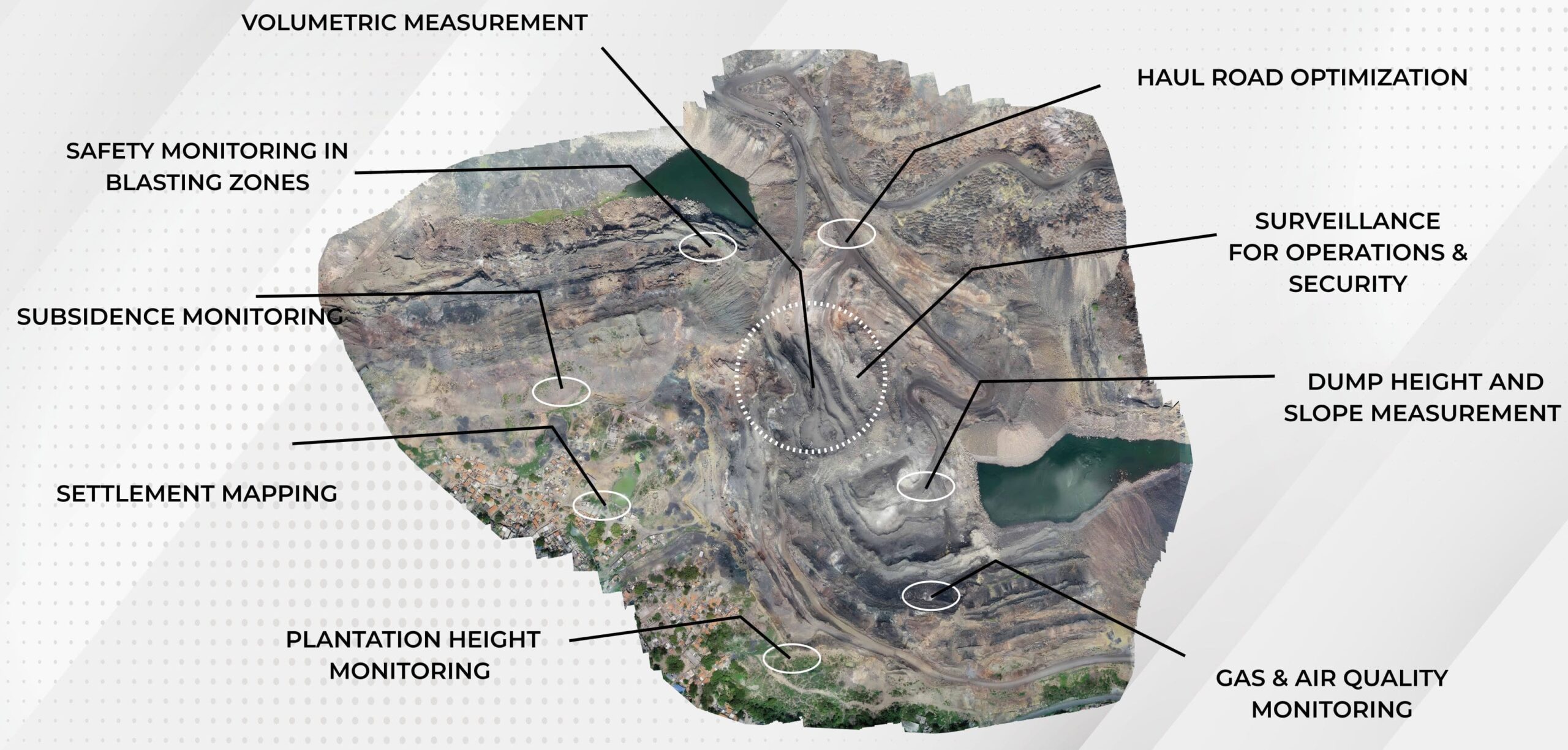
- Topographical survey and mapping
- Physical verification of stockpiles/OB Dumps and volumetric measurements of excavations
- Land Use Land Planning
- Environment Impact Assessment (EIA)
- Preparation of periodic mine operation plan and management
- Financial estimation of stockpiles
- Live footage of anti-pilferage operations
- Safety and surveillance monitoring
- Air & Gas Monitoring
- Pre- Construction Phase: Land Mapping services like Topo sheets, land use maps etc.
- Construction Phase: Project Progress monitoring
- Operation Phase:-
-
- Near Real-time monitoring operations in mines
- Pilferage monitoring
- Haul Road inspections
- OB dumping monitoring
- Vehicle tracking (both HEMM and others)
- Safety & Environment related blasting operations monitoring etc.
- Mine Closure stage: Mapping and comparing the actual mine position compared with the commitments made as per the approved “Mine Closure Plan”, etc.
- Measurements:-
-
- Accurate Stockpiles measurement
- Slope & Stability monitoring
- Accurate periodic measurement of all sorts of excavations in Mines (OB or coal or mineral excavated) etc.
Hi, Neat post. There is a problem with your web site in internet explorer, would test this?IE still is the market leader and a large portion of people will miss your great writing due to this problem.
Thanks for the distinct tips discussed on this blog. I have seen that many insurance agencies offer buyers generous special discounts if they prefer to insure more and more cars with them. A significant number of households include several automobiles these days, specially those with mature teenage young children still dwelling at home, and the savings in policies can certainly soon increase. So it pays off to look for a good deal.
I want to get across my admiration for your kindness in support of men and women that need assistance with this important question. Your real dedication to passing the solution around turned out to be astonishingly interesting and has regularly empowered many people just like me to attain their pursuits. The informative hints and tips implies a great deal to me and further more to my peers. Regards; from each one of us.
I have taken note that of all different types of insurance, medical care insurance is the most controversial because of the struggle between the insurance plan company’s duty to remain making money and the buyer’s need to have insurance coverage. Insurance companies’ commissions on health plans are low, consequently some businesses struggle to make a profit. Thanks for the concepts you write about through this blog.
Write more, thats all I have to say. Literally, it seems as though you relied on the video to make your point. You definitely know what youre talking about, why waste your intelligence on just posting videos to your blog when you could be giving us something enlightening to read?
WONDERFUL Post.thanks for share..extra wait .. ?
One thing is the fact one of the most prevalent incentives for utilizing your cards is a cash-back or perhaps rebate offer. Generally, you get 1-5 back on various expenses. Depending on the card, you may get 1 again on most purchases, and 5 again on acquisitions made from convenience stores, filling stations, grocery stores and ‘member merchants’.
F*ckin?awesome things here. I抦 very glad to look your post. Thank you so much and i am looking ahead to contact you. Will you kindly drop me a mail?
Greetings from California! I’m bored at work so I decided to check out your website on my iphone during lunch break. I love the info you present here and can’t wait to take a look when I get home. I’m surprised at how fast your blog loaded on my mobile .. I’m not even using WIFI, just 3G .. Anyhow, fantastic site!
Yet another thing is that while searching for a good on the internet electronics retail outlet, look for online stores that are frequently updated, retaining up-to-date with the most current products, the best deals, and also helpful information on services. This will make certain you are handling a shop that really stays over the competition and gives you what you need to make educated, well-informed electronics buying. Thanks for the essential tips I have really learned through the blog.
Yet another issue is that video games usually are serious anyway with the primary focus on mastering rather than fun. Although, it has an entertainment facet to keep your kids engaged, each and every game will likely be designed to work towards a specific set of skills or program, such as instructional math or scientific discipline. Thanks for your article.
Hi, It has come to our attention that you are using our client’s photographs on your site without a valid licence. We have already posted out all supporting documents to the address of your office. Please confirm once you have received them. In the meantime, we would like to invite you to settle this dispute by making the below payment of £500. Visual Rights Group Ltd, KBC Bank London, IBAN: GB39 KRED 1654 8703, 1135 11, Account Number: 03113511, Sort Code: 16-54-87 Once you have made the payment, please email us with your payment reference number. Please note that a failure to settle at this stage will only accrue greater costs once the matter is referred to court. I thank you for your cooperation and look forward to your reply. Yours sincerely, Visual Rights Group Ltd, Company No. 11747843, Polhill Business Centre, London Road, Polhill, TN14 7AA, Registered Address: 42-44 Clarendon Road, Watford WD17 1JJ
great post, very informative. I wonder why the other experts of this sector do not notice this. You must continue your writing. I’m sure, you’ve a great readers’ base already!
Hi there would you mind sharing which blog platform you’re using? I’m looking to start my own blog in the near future but I’m having a tough time choosing between BlogEngine/Wordpress/B2evolution and Drupal. The reason I ask is because your layout seems different then most blogs and I’m looking for something completely unique. P.S My apologies for being off-topic but I had to ask!
I抎 have to verify with you here. Which isn’t one thing I usually do! I take pleasure in reading a put up that may make folks think. Additionally, thanks for allowing me to comment!
I happen to be commenting to let you understand what a fine encounter our girl had visiting your webblog. She realized several pieces, which include how it is like to have a very effective teaching mood to let other people quite simply completely grasp certain multifaceted things. You really surpassed readers’ desires. Many thanks for displaying those insightful, safe, informative and in addition easy tips about your topic to Gloria.
I should say also believe that mesothelioma cancer is a scarce form of melanoma that is generally found in all those previously subjected to asbestos. Cancerous tissues form inside the mesothelium, which is a shielding lining that covers the majority of the body’s areas. These cells normally form in the lining of your lungs, abdomen, or the sac that encircles one’s heart. Thanks for expressing your ideas.
Hello there, just became aware of your blog through Google, and found that it is really informative. I抦 gonna watch out for brussels. I will appreciate if you continue this in future. Numerous people will be benefited from your writing. Cheers!
Thanks for your beneficial post. Through the years, I have been able to understand that the actual symptoms of mesothelioma are caused by a build up connected fluid involving the lining of the lung and the upper body cavity. The sickness may start inside chest location and get distributed to other limbs. Other symptoms of pleural mesothelioma include weight-loss, severe breathing trouble, vomiting, difficulty taking in food, and irritation of the neck and face areas. It needs to be noted that some people with the disease tend not to experience virtually any serious indicators at all.
Have you ever thought about adding a little bit more than just your articles? I mean, what you say is important and all. But think of if you added some great pictures or videos to give your posts more, “pop”! Your content is excellent but with images and clips, this blog could definitely be one of the most beneficial in its niche. Excellent blog!
My programmer is trying to persuade me to move to .net from PHP. I have always disliked the idea because of the expenses. But he’s tryiong none the less. I’ve been using Movable-type on a number of websites for about a year and am worried about switching to another platform. I have heard excellent things about blogengine.net. Is there a way I can import all my wordpress content into it? Any help would be greatly appreciated!
Thanks for the strategies you share through this website. In addition, lots of young women that become pregnant will not even seek to get medical health insurance because they are full of fearfulness they won’t qualify. Although many states at this point require that insurers provide coverage in spite of the pre-existing conditions. Premiums on most of these guaranteed programs are usually larger, but when considering the high cost of health care it may be any safer approach to take to protect your own financial potential.
Hi my friend! I wish to say that this post is amazing, great written and include almost all important infos. I would like to peer extra posts like this .
Thanks for any other magnificent post. Where else may just anyone get that type of info in such a perfect way of writing? I have a presentation next week, and I’m at the search for such information.
I must show my respect for your generosity for persons that need assistance with this particular niche. Your special dedication to getting the message up and down had become extraordinarily functional and have in most cases empowered those just like me to arrive at their goals. Your invaluable tutorial signifies a whole lot to me and extremely more to my office workers. Many thanks; from everyone of us.
An additional issue is really that video gaming became one of the all-time most significant forms of fun for people of any age. Kids participate in video games, plus adults do, too. The XBox 360 is probably the favorite video games systems for people who love to have a lot of activities available to them, along with who like to play live with other people all over the world. Many thanks for sharing your opinions.
Thanks for these tips. One thing I also believe is credit cards presenting a 0 monthly interest often bait consumers with zero interest rate, instant authorization and easy on-line balance transfers, nonetheless beware of the most recognized factor that can void your current 0 easy street annual percentage rate as well as throw one out into the bad house quick.
Have you ever considered about including a little bit more than just your articles? I mean, what you say is important and everything. However think of if you added some great pictures or video clips to give your posts more, “pop”! Your content is excellent but with images and video clips, this blog could certainly be one of the best in its niche. Excellent blog!
Does your site have a contact page? I’m having trouble locating it but, I’d like to send you an e-mail. I’ve got some ideas for your blog you might be interested in hearing. Either way, great blog and I look forward to seeing it develop over time.
One other issue is when you are in a circumstances where you will not have a co-signer then you may genuinely wish to try to make use of all of your educational funding options. You’ll find many awards and other scholarships or grants that will offer you funds to help you with university expenses. Many thanks for the post.
I think this is among the most vital info for me. And i am glad reading your article. But should remark on few general things, The site style is great, the articles is really nice : D. Good job, cheers
rüzgar kırdı dalımı, ellerin günahı ne?
I have observed that car insurance organizations know the cars and trucks which are at risk of accidents along with risks. Additionally , they know what form of cars are inclined to higher risk as well as the higher risk they have the higher the premium fee. Understanding the uncomplicated basics with car insurance will help you choose the right kind of insurance policy that will take care of your family needs in case you become involved in an accident. Thanks for sharing the actual ideas on the blog.
I have been surfing online more than three hours today, yet I never found any interesting article like yours. It is pretty worth enough for me. Personally, if all site owners and bloggers made good content as you did, the web will be a lot more useful than ever before.
Hello, you used to write magnificent, but the last few posts have been kinda boring?I miss your super writings. Past few posts are just a little bit out of track! come on!
I am not sure where you are getting your info, but great topic. I needs to spend some time learning more or understanding more. Thanks for great info I was looking for this information for my mission.
Simply desire to say your article is as surprising. The clearness for your post is simply great and i could suppose you’re knowledgeable in this subject. Fine together with your permission let me to clutch your feed to keep up to date with imminent post. Thank you a million and please continue the enjoyable work.
I am not sure where you are getting your info, but great topic. I needs to spend some time learning more or understanding more. https://healthfalls.com/keto-acv-gummies-the-ultimate-guide/
Of course, what a splendid website and illuminating posts, I will bookmark your site.All the Best!
What抯 Happening i’m new to this, I stumbled upon this I have found It positively useful and it has aided me out loads. I hope to contribute & help other users like its aided me. Good job.
Thanks for another magnificent article. Where else could anyone get that kind of information in such a perfect way of writing? I have a presentation next week, and I’m on the look for such information.
Thanks for the ideas you discuss through this web site. In addition, numerous young women that become pregnant do not even try and get health insurance coverage because they worry they might not qualify. Although a few states right now require that insurers supply coverage despite the pre-existing conditions. Premiums on these kinds of guaranteed options are usually higher, but when with the high cost of health care it may be some sort of a safer way to go to protect a person’s financial potential.
I must point out my affection for your generosity for those people who have the need for assistance with that theme. Your very own commitment to getting the message along became amazingly good and has specifically helped others much like me to reach their pursuits. Your entire important help and advice signifies a whole lot to me and further more to my peers. Thanks a ton; from all of us.
rSGfaILcnObP
Very nice info and right to the point. I don’t know if this is in fact the best place to ask but do you folks have any ideea where to employ some professional writers? Thanks 🙂
I carry on listening to the news bulletin talk about getting boundless online grant applications so I have been looking around for the finest site to get one. Could you advise me please, where could i get some?
I would like to thank you for the efforts you’ve put in writing this website. I am hoping the same high-grade site post from you in the upcoming also. In fact your creative writing abilities has encouraged me to get my own site now. Actually the blogging is spreading its wings rapidly. Your write up is a great example of it.
Howdy! I know this is somewhat off topic but I was wondering if you knew where I could find a captcha plugin for my comment form? I’m using the same blog platform as yours and I’m having trouble finding one? Thanks a lot!
I have to express my thanks to this writer for rescuing me from this particular situation. Because of checking through the search engines and getting things that were not beneficial, I figured my life was over. Existing minus the strategies to the problems you have sorted out by way of your write-up is a crucial case, as well as the ones that might have badly damaged my career if I hadn’t come across your web site. Your main know-how and kindness in maneuvering all the stuff was important. I am not sure what I would have done if I had not encountered such a point like this. I can at this point look forward to my future. Thanks for your time very much for the professional and result oriented guide. I won’t be reluctant to suggest your web page to any person who would need assistance on this situation.
There are definitely a whole lot of particulars like that to take into consideration. That may be a great level to deliver up. I offer the ideas above as basic inspiration however clearly there are questions just like the one you convey up the place the most important factor might be working in honest good faith. I don?t know if finest practices have emerged round things like that, but I am sure that your job is clearly identified as a good game. Each boys and girls feel the influence of only a second抯 pleasure, for the rest of their lives.
Thanks for the unique tips provided on this blog site. I have seen that many insurance companies offer consumers generous special discounts if they choose to insure many cars with them. A significant amount of households have several automobiles these days, particularly people with more aged teenage children still residing at home, plus the savings with policies might soon begin. So it is a good idea to look for a great deal.
Thanks for your post. One other thing is individual states have their particular laws that will affect home owners, which makes it quite difficult for the the nation’s lawmakers to come up with a brand new set of recommendations concerning property foreclosure on home owners. The problem is that every state has got own guidelines which may work in a damaging manner in regards to foreclosure guidelines.
Hi, Neat post. There’s a problem with your web site in internet explorer, would check this?IE still is the market leader and a huge portion of people will miss your fantastic writing due to this problem.
Nice blog right here! Additionally your website so much up very fast! What host are you the usage of? Can I am getting your associate link in your host? I want my website loaded up as quickly as yours lol
very nice post, i certainly love this website, keep on it
Nice blog here! Also your web site loads up very fast! What web host are you using? Can I get your affiliate link to your host? I wish my web site loaded up as fast as yours lol
Hi would you mind stating which blog platform you’re working with? I’m going to start my own blog soon but I’m having a hard time deciding between BlogEngine/Wordpress/B2evolution and Drupal. The reason I ask is because your design and style seems different then most blogs and I’m looking for something completely unique. P.S Sorry for getting off-topic but I had to ask!
Very good written post. It will be useful to anybody who usess it, as well as me. Keep up the good work – looking forward to more posts.
A person essentially help to make seriously posts I would state. This is the first time I frequented your web page and thus far? I amazed with the research you made to create this particular publish extraordinary. Great job!
I really appreciate this post. I抳e been looking all over for this! Thank goodness I found it on Bing. You have made my day! Thank you again
hello!,I like your writing so much! share we communicate more about your post on AOL? I require an expert on this area to solve my problem. May be that’s you! Looking forward to see you.
I appreciate, cause I found exactly what I was looking for. You have ended my 4 day long hunt! God Bless you man. Have a nice day. Bye
Useful information. Lucky me I found your web site accidentally, and I am shocked why this coincidence didn’t happened earlier! I bookmarked it.
Hey are using WordPress for your site platform? I’m new to the blog world but I’m trying to get started and create my own. Do you need any html coding expertise to make your own blog? Any help would be greatly appreciated!
Hello this is kind of of off topic but I was wanting to know if blogs use WYSIWYG editors or if you have to manually code with HTML. I’m starting a blog soon but have no coding expertise so I wanted to get advice from someone with experience. Any help would be greatly appreciated!
Youre so cool! I dont suppose Ive read something like this before. So nice to search out any person with some unique ideas on this subject. realy thank you for starting this up. this website is something that’s needed on the internet, someone with a bit of originality. useful job for bringing something new to the web!
I have discovered some new things from your web site about personal computers. Another thing I’ve always assumed is that computer systems have become a product that each house must have for many people reasons. They supply you with convenient ways to organize the home, pay bills, shop, study, listen to music and perhaps watch television shows. An innovative way to complete every one of these tasks is with a computer. These desktops are portable ones, small, potent and portable.
One more issue is that video games are normally serious naturally with the main focus on mastering rather than amusement. Although, there is an entertainment factor to keep your children engaged, each and every game is usually designed to work with a specific set of skills or area, such as mathematics or scientific disciplines. Thanks for your article.
Do you mind if I quote a few of your articles as long as I provide credit and sources back to your weblog? My website is in the very same area of interest as yours and my users would really benefit from some of the information you provide here. Please let me know if this ok with you. Regards!
you may have an incredible blog right here! would you prefer to make some invite posts on my weblog?
I just could not go away your web site before suggesting that I extremely loved the standard information an individual provide for your visitors? Is gonna be back often to check up on new posts
I抎 should verify with you here. Which is not something I usually do! I take pleasure in studying a post that may make individuals think. Additionally, thanks for allowing me to comment!
whoah this blog is wonderful i love reading your posts. Keep up the great work! You know, lots of people are looking around for this info, you can help them greatly.
Another issue is really that video gaming became one of the all-time greatest forms of fun for people of every age group. Kids engage in video games, and adults do, too. The actual XBox 360 is among the favorite games systems for those who love to have hundreds of activities available to them, and who like to relax and play live with people all over the world. Thanks for sharing your thinking.
whoah this blog is wonderful i love reading your posts. Keep up the great work! You know, lots of people are hunting around for this info, you can aid them greatly.
Nice post. I be taught one thing more challenging on totally different blogs everyday. It is going to at all times be stimulating to learn content material from other writers and follow just a little something from their store. I抎 choose to use some with the content on my blog whether or not you don抰 mind. Natually I抣l offer you a hyperlink in your web blog. Thanks for sharing.
Definitely believe that which you said. Your favorite justification seemed to be on the internet the easiest thing to be aware of. I say to you, I certainly get annoyed while people consider worries that they just don’t know about. You managed to hit the nail upon the top and also defined out the whole thing without having side-effects , people can take a signal. Will probably be back to get more. Thanks
[url=https://tadalafilu.online/]6mg tadalafil[/url]
[url=http://medicinesaf.online/]reputable indian pharmacies[/url]
[url=http://synthroidx.com/]synthroid uk[/url]
[url=https://olisinopril.com/]zestril[/url]
[url=https://happyfamilymedicalstore.online/]family care rx[/url]
[url=https://valtrexmedication.online/]buy valtrex over the counter[/url]
[url=https://tadalafilgf.com/]cialis soft 20 mg[/url]
[url=http://happyfamilystorerx.online/]happy family store viagra[/url]
XTYpsrwdEqF
[url=http://bestmedsx.online/]safe online pharmacies[/url]
[url=http://predniso.online/]40 mg prednisone daily[/url]
[url=https://tadalafi.online/]buy cialis in usa online[/url]
[url=http://tadalafilstd.com/]cheap tadalafil 20mg[/url]
[url=https://oazithromycin.com/]azithromycin 500 mg pills[/url]
[url=https://tadalafilstd.com/]united states tadalafil[/url]
That is really attention-grabbing, You’re a very professional blogger. I’ve joined your rss feed and look ahead to searching for extra of your excellent post. Also, I’ve shared your site in my social networks
https://englishmax.ru/
[url=http://synthroidx.com/]synthroid 100mcg tab[/url]
[url=http://bestmedsx.online/]canadianpharmacyworld com[/url]
[url=https://lisinoprilos.online/]zestoretic medication[/url]
[url=https://happyfamilymedicalstore.online/]pharmacy online track order[/url]
[url=https://valtrexid.com/]2870 valtrex[/url]
MrbJEiqtS
[url=http://happyfamilymedicalstore.online/]reputable online pharmacy no prescription[/url]
[url=http://tadalafi.online/]purchase generic cialis online[/url]
[url=http://prednisonecsr.com/]prednisone 60 mg price[/url]
[url=https://bestmedsx.com/]onlinepharmaciescanada[/url]
[url=http://tadalafilgf.com/]buy cialis 60 mg online[/url]
[url=http://tadalafilstd.com/]tadalafil soft tabs 20mg[/url]
[url=http://azithromycinmds.com/]buy zithromax online uk[/url]
batmanapollo.ru
YourDoll JP 驚くほど賢明な男性のダッチワイフが人気を博している
[url=https://isynthroid.com/]synthroid 100 mcg cost[/url]
sCHkLDSOEGtUhrpx
[url=http://tadalafilstd.com/]tadalafil capsules[/url]
[url=http://tadalafilu.com/]tadalafil soft[/url]
dark web access [url=https://mydarkmarket.com/ ]blackweb [/url] dark web sites links
[url=http://accutaneiso.online/]accutane price nz[/url]
Contra vim mortis non est medicamen in hortis — Против силы смерти в садах нет лекарств.
canadian pharmacies mail order
https://canadianpharmaceuticalshelp.com/
[url=https://canadianpharmaceuticalshelp.com/]best canadian mail order pharmacies[/url]
[url=http://eflomax.com/]buy flomax online[/url]
[url=https://lasixav.online/]buy fourosimide on line[/url]
blackweb official website [url=https://mydarknetmarketlinks.com/ ]dark website [/url] darknet drug links
Тут психолог
Many thanks for this informative article. It’s been extremely informative , and provided great insights. For those who are interested in viral real estate SEO, make sure to explore https://www.elevenviral.com to learn more.
best darknet markets [url=https://mydarknetmarketlinks.com/ ]deep web drug links [/url] deep web drug links
[url=https://ciproffl.online/]cipro lowest price[/url]
[url=http://tretinoineff.online/]tretinoin 05 cream cost[/url]
22 закона управления людьми и лучшие обзоры по психотерапии.
canadian online pharmacies reviews
https://canadianpharmaceuticalshelp.com/
[url=https://canadianpharmaceuticalshelp.com/]online ed drugs no prescription[/url]
Veni, vidi, vici
[url=http://sildalis.store/]sildalis without prescription[/url]
Per aspera ad astra
Смотреть фильм 100 лет тому вперед бесплатно. Смотреть бесплатно 100 лет тому вперед.
Смотреть онлайн 100 лет тому вперед. Фильм 100 лет тому вперед смотреть онлайн.
Thank you for this enlightening article. It was extremely informative and delivered valuable knowledge. Should you be looking to learn more about the world of viral real estate SEO, be sure to visit https://www.elevenviral.com for more information.
Фоллаут смотреть
[url=http://xlyrica.com/]lyrica cost uk[/url]
[url=https://dexamethasonen.com/]dexamethasone 25 mg[/url]
Thanks for the thoughts you reveal through this website. In addition, numerous young women who seem to become pregnant never even aim to get medical health insurance because they worry they probably would not qualify. Although a lot of states currently require that insurers offer coverage irrespective of the pre-existing conditions. Rates on these types of guaranteed programs are usually bigger, but when with the high cost of medical treatment it may be any safer approach to take to protect one’s financial future.
I’m thoroughly captivated by the profound understanding and excellent way of expressing complex ideas. The knowledge you share clearly stands out in every piece you write. It’s clear that you spend considerable time into understanding your topics, and this effort pays off. We appreciate your efforts in sharing such valuable insights. Keep on enlightening us! https://www.elevenviral.com
Super-Duper site! I am loving it!! Will come back again. I am taking your feeds also.
[url=https://enolvadex.com/]nolvadex tablets online[/url]
geinoutime.com
Fang Jifan은 마음 속으로 혼돈을 끝내려면 내년까지 기다려야 할 것이므로 시간을 내십시오.
Thanks for the several tips discussed on this blog site. I have observed that many insurance companies offer shoppers generous deals if they elect to insure multiple cars with them. A significant volume of households currently have several cars these days, particularly people with older teenage youngsters still dwelling at home, along with the savings with policies can certainly soon mount up. So it will pay to look for a great deal.
Уэнздей 2 сезон смотреть онлайн
cheapest drug prices
2024 Море
Why did the Nvidia GeForce card bring a ladder to the gaming party? Because it wanted to reach new heights in performance!
Thanks a bunch for sharing this with all people you actually recognise what you’re speaking approximately! Bookmarked. Kindly also talk over with my web site =). We could have a hyperlink exchange contract among us!
Why do Nvidia GeForce cards make great friends? Because they always have your back when the graphics get tough!
geinoutime.com
Suleiman은 차갑게 말했습니다. “무슨 말을하고 싶니?”
Nice blog! Is your theme custom made or did you download it from somewhere? A theme like yours with a few simple tweeks would really make my blog shine. Please let me know where you got your design. With thanks
[url=http://oazithromycin.com/]azithromycin us[/url]
Reduslim – die ultimative Lösung zur Gewichtsreduktion oder nur ein weiterer Hype?
Die Erfahrungen aus der Höhle der Löwen zeigen, dass dieses Produkt einen wahren Durchbruch auf dem Markt
für Gewichtsverlust darstellt.
Viele Menschen haben bereits positive Erfahrungen mit Reduslim gemacht
und berichten von erstaunlichen Ergebnissen. Die einzigartige
Formel von Reduslim kombiniert natürliche Inhaltsstoffe, die den Stoffwechsel ankurbeln und die Fettverbrennung beschleunigen.
Dank der Unterstützung von Investoren aus der Höhle der Löwen konnte Reduslim weiterentwickelt und verfeinert werden. Die Kombination aus wissenschaftlich fundierten Inhaltsstoffen und innovativen Technologien macht Reduslim zu einem der
effektivsten Mittel zur Gewichtsreduktion auf dem Markt.
Die positiven Erfahrungen aus der Höhle der Löwen zeigen, dass Reduslim eine nachhaltige und gesunde Methode zur
Gewichtsreduktion ist. Probieren auch Sie es aus
und überzeugen Sie sich selbst von den beeindruckenden Ergebnissen!
my web site; reduslim kaufen apotheke (https://reduslim.at)
https://gogocasino.one
I’m thoroughly captivated by your profound understanding and superb writing style. The knowledge you share clearly stands out in each paragraph. It’s clear that you invest a great deal of effort into researching your topics, and the results is well-appreciated. Thank you for sharing such detailed information. Keep up the great work! https://www.elevenviral.com
Король и шут 1 сезон фильм
k8 カジノ 誕生日ボーナス
このブログはいつも私の期待を超える情報を提供してくれます。本当にありがとう。
geinoutime.com
그래서 선원들은 장헬링을 한 사람 한 사람 머뭇거리며 바라보았다.
Психолог 2026
I’m thoroughly captivated by your profound understanding and stellar ability to convey information. Your expertise shines through in every piece you write. It’s evident that you invest a great deal of effort into delving into your topics, and the results is well-appreciated. Thanks for providing this valuable knowledge. Keep up the great work! https://www.elevenviral.com
Terrific post however I was wondering if you could write a litte more on this subject? I’d be very grateful if you could elaborate a little bit further. Bless you!
[url=https://odiflucan.com/]buy diflucan online uk[/url]
I’m truly impressed with your deep insights and excellent way of expressing complex ideas. Your expertise clearly stands out in each paragraph. It’s obvious that you invest a great deal of effort into understanding your topics, and that effort is well-appreciated. Thanks for providing this valuable knowledge. Keep up the great work! https://www.elevenviral.com
[url=https://eflomax.com/]noroxin[/url]
k8 カジノ とは
この記事の実用性は驚くべきものがあり、大変役に立ちました。
I’m truly impressed with your profound understanding and superb way of expressing complex ideas. Your depth of knowledge clearly stands out in every piece you write. It’s evident that you put a lot of effort into delving into your topics, and this effort is well-appreciated. We appreciate your efforts in sharing such valuable insights. Keep up the great work! https://www.elevenviral.com
### Смотреть русские сериалы онлайн
Русские сериалы пользуются огромной популярностью среди зрителей благодаря своей разнообразной тематике, качественной актерской игре и захватывающим
сюжетам. Сегодня у нас есть уникальная возможность наслаждаться лучшими русскими сериалами онлайн, не выходя из дома.
**Преимущества просмотра русских сериалов онлайн**
1. **Доступность**. Онлайн-платформы
предлагают огромный выбор русских сериалов, которые можно
смотреть в любое время и в любом месте.
Это особенно удобно для тех, кто
имеет плотный график и не может подстраиваться под телевизионные трансляции.
2. **Бесплатность**. Множество сайтов предлагают бесплатный просмотр сериалов, что
позволяет экономить на подписках и кабельном телевидении.
Пользователи могут наслаждаться
любимыми шоу без дополнительных затрат.
3. **Высокое качество**. Современные онлайн-платформы обеспечивают высокое качество видео и звука, что позволяет наслаждаться
сериалами в наилучшем качестве.
Многие сайты предлагают сериалы в формате HD и даже 4K.
4. **Разнообразие контента**.
В интернете можно найти русские сериалы на любой
вкус: от классических драм и комедий до современных детективов и фантастики.
Это позволяет каждому зрителю найти что-то по своему
вкусу.
**Популярные жанры русских сериалов**
– **Драмы**. Сериалы, основанные на
глубоких человеческих историях, всегда
находят отклик у зрителей. Примеры: “Доктор Рихтер”, “Тест на беременность”.
– **Комедии**. Легкие и забавные сериалы,
которые поднимают настроение.
Примеры: “Кухня”, “Интерны”.
– **Детективы**. Захватывающие истории с расследованиями и неожиданными поворотами сюжета.
Примеры: “Мажор”, “След”.
– **Исторические**. Сериалы, рассказывающие о важных событиях и
личностях в истории России. Примеры: “Екатерина”, “София”.
– **Фантастика и мистика**. Увлекательные сюжеты с элементами фантастики
и мистики. Примеры: “Тайны следствия”, “Метод”.
**Где смотреть русские сериалы онлайн**
Существует множество платформ, предлагающих просмотр русских сериалов онлайн.
.
Смотрите русские сериалы
онлайн и наслаждайтесь качественным контентом в удобное для вас
время. Это отличный способ расслабиться, получить новые впечатления и узнать больше о современной русской культуре.
my blog “https://wiki.team-glisto.com/index.php?title=Benutzer:DesmondDelprat”
geinoutime.com
인턴은 여전히 매우 유용하고 저렴하며 유능합니다.
Good post. I learn something more difficult on totally different blogs everyday. It’ll at all times be stimulating to read content material from other writers and observe just a little one thing from their store. I抎 want to use some with the content material on my weblog whether you don抰 mind. Natually I抣l give you a link in your net blog. Thanks for sharing.
Valvrave the Liberator
非常に興味深く、思考を刺激する内容でした。また訪れます。
I believe that avoiding highly processed foods would be the first step for you to lose weight. They will often taste beneficial, but prepared foods have very little vitamins and minerals, making you consume more just to have enough electricity to get through the day. If you’re constantly taking in these foods, transferring to grain and other complex carbohydrates will help you have more energy while feeding on less. Interesting blog post.
Wonderful goods from you, man. I have be aware your stuff prior to and you are simply extremely great. I really like what you’ve received right here, really like what you’re stating and the way by which you assert it. You’re making it entertaining and you continue to take care of to keep it sensible. I cant wait to learn far more from you. This is really a wonderful web site.
Great work! That is the type of information that are supposed to be shared around the internet. Shame on the search engines for not positioning this submit upper! Come on over and talk over with my website . Thank you =)
Thanks for the ideas you talk about through this website. In addition, several young women that become pregnant usually do not even try and get medical insurance because they dread they won’t qualify. Although many states today require that insurers provide coverage in spite of the pre-existing conditions. Costs on all these guaranteed plans are usually higher, but when with the high cost of health care bills it may be your safer way to go to protect a person’s financial potential.
geinoutime.com
황태자에게 자식이 없는 것은 큰일이지만, 이제 드디어 모두의 마음이 무너졌다.
k8 カジノ ログイン
この記事には心から共感しました。とても感動しました。
Trải nghiệm những cơ hội đáng mong chờ tại https://yo88.com/, nơi vô số trải nghiệm chơi game tuyệt vời đang chờ đợi.
ЗдравБудь – популярный сайт о здоровье. Здесь узнаете, что такое микробиом, чем может помочь нутрициолог, где искать витамины зимой, зачем проверяют уровень гормонов щитовидки, необходимо ли принимать йод для профилактики и др. У нас вы также найдете рецепты вкусной еды. Мы предоставляем исключительно полезную и интересную информацию. https://zdravbud.net/new/pochemu-bolyat-sustavy – здесь подробнее объясняем, почему суставы болят. Разъясним, как МолекАРТ-РА действует. Заходите на наш портал уже сейчас, вас ждут самые лучшие статьи!
Olymp Trade https://olymptrade-app.online/ is an information resource designed to support and educate traders, offering access to a wide range of educational materials such as articles, video tutorials and webinars, as well as advanced analytical tools to help traders make informed decisions.
L Evangelion ~Creation for the future~
いつも興味深いトピックを提供してくれてありがとう。
На сайте https://ruuserial.net/ посмотрите интересные, увлекательные, новые, а также полюбившиеся сериалы, которые откроют для вас новые горизонты. В них играют талантливые актеры, которые у всех на устах. Для того чтобы подобрать определенный фильм, необходимо воспользоваться специальным фильтром по жанру: комедия, триллер, драма, криминал, детективы, военные. Также получится сделать подборку и по году выпуска. Регулярно на сайте происходят обновления, чтобы вы посмотрели такое кино, которое хочется.
Сайт chasnovyn.com.ua – это источник актуальных новостей Украины, которые в доступе 24/7. Статьи снабжены четкими фотографиями. Мы ценим своих читателей и гордимся тем, что можем предложить им самое лучшее. Устраивайтесь поудобнее и читайте важную информацию. chasnovyn.com.ua – https://chasnovyn.com.ua сайт, который действительно заслуживает вашего внимания. Здесь вы найдете темы экономики, политики и другое. Все материалы надежные, не сомневайтесь в их качестве. Посетите наш ресурс и будете в курсе актуальных событий!
На сайте https://t.me/m1xbet_ru ознакомьтесь с актуальной и интересной информацией, которая касается проекта «1XBET». Заходите на официальный канал и ознакомьтесь со всеми интересующими новостями, актуальными данными, которые вызовут интерес у всех игроков и любителей азарта. На этом сайте постоянно публикуются свежие, интересные новости из мира ставок и гемблинга. Воспользуйтесь и вы возможностью узнать первым о промокодах, предстоящих акциях. Заходить на канал можно в любое время и с любого гаджета.
На сайте https://truba-almaty.kz/ закажите полиэтиленовые фитинги и трубы. Предприятие ТОО «ТОРГПРОМПЛАСТ» работает в этой сфере длительное время и сотрудничает как с физическими, так и юридическими лицами. Регулярно проводятся акции, действуют скидки, программа лояльности для постоянных клиентов. Работа без посредников, что позволяет снизить траты, избежать переплат. Прямо сейчас вы сможете приобрести трубы с хорошей скидкой. Есть своя производственная база, укомплектованная высокотехнологичным оборудованием.
Портал uafakty.com.ua его пользователи отмечают лаконичность оформления. Здесь затрагиваются темы культуры, политики, спорта. Вас ждут актуальные новости шоу-бизнеса. Получайте удовольствие от лучшего контента! uafakty.com.ua – https://uafakty.com.ua портал, который ценится за объективность и оперативность, он вам будет понятен. Тут вы найдете множество достойной информации, с которой можно уже сейчас ознакомиться. Все статьи удобны для чтения и снабжены фотографиями. Заходите уже сейчас на наш известный портал и читайте последние новости!
Краснодарский завод, производимое им котельное оборудование, проходит регламентированные технические испытания, поэтому отвечает необходимым требованиям безопасности. Работаем по всей Российской Федерации и ряду стран СНГ. С нами вы существенно экономите собственное время и денежные средства. Ищете паровой промышленный паровой котел под давлением? Kzko-gaz.ru – сайт, где есть каталог и представлены отзывы о нашем заводе, ознакомиться с ними можно прямо сейчас. Любой изготавливаемый котел либо же котельная будут в срок доставлены, не сомневайтесь. Гарантируем качество, создавая тепло!
Претенденты смотреть Претенденты фильм, 2024, смотреть онлайн
На сайте https://ntmsp.ru/ закажите звонок для того, чтобы воспользоваться услугами популярной компании ООО «НОВЫЕ ТЕХНОЛОГИИ И МАТЕРИАЛЫ». Она предпринимает все возможное для того, чтобы создать продукцию эталонного качества и соответствующую самым высоким требованиям. В каталоге вы найдете крепеж, ферритовые изделия, медицинские иглы, а также оснастку и многое другое. Все это эталонного качества, реализуется по привлекательной стоимости. В компании трудятся компетентные, надежные специалисты, которые на совесть выполняют работу.
На сайте https://uss.eu.com изучите интересную, увлекательную и свежую информацию на самую разную тему. Здесь опубликован материал о красивых украшениях. Предлагается ознакомиться с бестселлерами. Также есть данные о том, как правильно увеличить свой охват в Интернете. Имеется полный список компаний, которые пригодятся владельцам предприятий. Обязательно ознакомьтесь со списком лучших форумов, которые представлены в Интернете. Опубликованы и самые лучшие, проверенные англоязычные форумы, на которые вы сможете зайти прямо сейчас.
На сайте https://womans-life.ru почитайте актуальную, ценную и интересную информацию на самую разную тему. К примеру, вы узнаете о том, как новогодние праздники отражаются на здоровье, о методиках выведения прыщей в домашних условиях, каким образом лучше всего зашить обувь, как правильно завязать шарф на голове. Представлены самые разные интересные советы, которые помогут решить проблему. Есть и нужные сведения о том, как правильно соединить чулки с поясом. Опубликованы рекомендации от медиков, которые помогут избавиться от болей в поджелудочной железе.
На сайте https://t.me/mvulkan_ru получите интересную, увлекательную информацию о казино «Вулкан 24». Официальный канал теперь находится в вашем мобильном телефоне. Это заведение считается лидером в своем сегменте, а потому ему точно можно доверять. Предлагает огромный выбор автоматов на любой вкус, много развлечений, которые точно понравятся и вам. На канале несколько тысяч записей, а также есть фотографии. Воспользуйтесь и вы возможностью попытать свою удачу, сыграв в интересные развлечения.
На сайте http://ritualnoe-buro-vrn.ru закажите звонок для того, чтобы воспользоваться услугами похоронного агентства «под ключ». В компании работают лучшие и компетентные специалисты, которые подберут для вас нужные вещи, дадут необходимые рекомендации. Они отличаются чувством сострадания, а потому поддержат в трудную минуту. Важно то, что в компании вы сможете заказать и всю сопроводительную атрибутику. Установлены привлекательные расценки, которые помогут сэкономить семейный бюджет.
Go to the site https://miglandrealestate.com/ and you can find real estate on the island of Bali. Buying, renting land or villas and houses is very simple. We present the best offers at the best prices. We have the latest information about properties in Bali.
На сайте https://sobr26.ru ознакомьтесь с номером телефона охранной организации СОБР. Здесь оказываются услуги, связанные с охраной недвижимости, организуется безопасность объекта, есть возможность воспользоваться физической охраной, которая оказывается более 20 лет. Прямо сейчас вы сможете рассчитывать на бесплатную консультацию. Каждый клиент сможет организовать пультовую, физическую охрану, пожарную сигнализацию, видеонаблюдение. Для того чтобы воспользоваться услугами, оставьте заявку непосредственно на сайте.
Rassilka.kz оказывает высококачественные услуги. Делаем ватсап, смс, email, рассылки по Нур-Султану, Алматы и Казахстану. Сотрудничаем с разными популярными компаниями. Наша главная задача – принести всем клиентам пользу. Действия на конечный итог нацелены. https://rassilka.kz – сайт, где вы узнаете, почему выбирают именно нас. Здесь у вас есть возможность уже сейчас посмотреть тарифы. У вас есть возможность получить бесплатную консультацию. Мы с удовольствием ответим на все ваши вопросы, свяжитесь с нами в любое время.
I like the helpful info you provide in your articles. I will bookmark your blog and check again here regularly. I am quite sure I抣l learn many new stuff right here! Good luck for the next!
Срочный заказ машины для вывоза мусора на сайте https://xn—–dlcapan5bbljbbybmd5a7f0c.xn--p1ai/ от профессионалов. От заявки до приезда 20 минут. Работаем в Москве и за МКАД. Официальная утилизация мусора, лучшие условия. Документы. Работаем с 2008 года. Звоните, пишите – консультируем круглосуточно.
Thanks for your write-up. One other thing is that if you are marketing your property on your own, one of the challenges you need to be conscious of upfront is just how to deal with household inspection accounts. As a FSBO owner, the key to successfully moving your property and also saving money on real estate agent income is awareness. The more you realize, the better your property sales effort might be. One area in which this is particularly critical is assessments.
Сайт ukrayinka.com.ua пользуется невероятной популярностью и станет вам верным другом. Мы освещаем общественно-политические и экономические события в Украине. Предоставляем исключительно высококачественную информацию. ukrayinka.com.ua – https://ukrayinka.com.ua портал, который будет понятен каждому пользователю. Здесь имеются статьи с четкими фотографиями. Рапологайтесь поудобнее и читайте новости. Готовы обеспечить вас всеми необходимыми сведениями. Смело выбирайте наш портал, если цените наполненность и свежесть. Вы не пожалеете об этом!
На сайте https://hyips-money.ru/ ознакомьтесь с инвестиционными проектами, рекомендациями, которые помогут заработать неплохие средства. Этот сервис регулярно мониторит те проекты, которые действительно приносят прибыль, где вас точно не обманут, а деньги выплатят быстро и без обмана. Здесь получится отыскать всю необходимую информацию относительно инвестиционных проектов. Изучите полный список хайп-проектов, которые будут полезны и вам. Регулярно проверяется платежеспособность, чтобы исключить возможные денежные потери.
На сайте https://t.me/s/m_1go ознакомьтесь со всей важной, ценной информацией, которая касается проекта «1GO». Здесь публикуются различные акции, промокоды, также вся важная информация относительно клуба. Воспользуйтесь ей и вы, чтобы выиграть приличную сумму денег на свою мечту. В этом казино имеется все, нужно, включая классические слоты, а также удивительные новинки, которые вызовут интерес у каждого. Попытайте свои силы и вы, чтобы получить максимум пользы и приятные эмоции. На этом канале всегда появляются новые сведения, данные из сферы гемблинга.
На сайте https://polygrav.ru вы сможете заказать такую услугу, как производство бейджей, табличек, а также номерков, шильдиков в огромном ассортименте. Только в этой компании вы отыщите огромное количество наиболее выгодных, интересных предложений. Производство является высокотехнологичным, а потому есть возможность заказать товары в любом количестве. Также вы сможете приобрести таблички на дверь, номерки для гардероба. Вся продукция производится из высокотехнологичных материалов, которые не испортят внешний вид.
[url=http://adexamethasonep.online/]dexamethasone generic brand[/url]
Вывоз и утилизация мусора срочно https://vivozim-musor.pro/ закажите на сайте. Профессиональный подход, лучшие условия и цены, круглосуточная работа. Выберите удобное время для вас, а мы сделаем свою работу. Заказать вывоз мусора в Москве можно по телефону на сайте.
Dinopolis считается самым забавным онлайн-слотом, дарящий множество позитивных эмоций. Игра не оставляет никого равнодушным, потому как имеет отменную анимацию, звук и графику. Предлагаем вам невероятное путешествие в мир динозавров. У вас есть возможность, играя, зарабатывать реальные деньги. Приготовьтесь к веселью и адреналину. https://dinopolisgame.com/ru/ – сайт, где о данном слоте можно найти интересную информацию. Узнаете, сколько можно выиграть и как сделать ставку в игре Динополис. Желаем вам удачи в Dinopolis!
Taker – казино, которое обеспечивает безопасность и честность игры. Такер привлекает игроков занимательными слотами, онлайн-казино постоянно предоставляет выгодные бонусы и акции. Саппорт отзывчивый, работает оперативно и вежливо, вывод средств – быстрый. Ищете тейкер? Taker.bond – сайт, дизайн его превосходный, с навигацией сложностей не возникнет. Если вы решили посетить Taker casino, вам повезло, потому что здесь представлен впечатлительный выбор азартных игр. Вам скучно точно не будет. Испытайте удачу прямо сейчас!
На сайте https://bettingsport.pro/ изучите рейтинг самых проверенных, надежных букмекерских контор. Им точно можно доверять, ведь они действительно выплачивают средства, предлагают огромное количество бонусов, различных привилегий для всех пользователей. Именно поэтому не составит труда подобрать идеального партнера для того, чтобы заработать побольше денег и сделать ставки в этом году. Только для вас лучшие конторы, к которым точно стоит присмотреться! Все правдивые отзывы игроков и многое другое только на этом сайте.
На сайте https://prometall.shop/ каждый желающий сможет выбрать и приобрести банные печи в сетке, в камне, отопительные печи, которые отличаются повышенной надежностью, практичностью и высоким сроком эксплуатации. Интернет-бутик предлагает только лучшие конструкции, которые принесут радость и пользу от использования. Также имеются и хиты продаж, которые выбирает большинство. Ознакомьтесь с печами в облицовке. Все изделия наделены безупречными эстетическими свойствами, а потому идеально впишутся в любую концепцию.
снятие похмельного синдрома https://narcolog-expert.ru/
На сайте https://tips-for-women.ru собраны самые полезные рекомендации относительно женской красоты. Так вы получите информацию о том, что представляет собой холодная укладка, плампер для губ, а также почему волосы стали быстрее пачкаться. Также имеется интересная, уникальная информация о том, как правильно о себе заботиться, сохранить здоровье. Вы будете знать о том, как сохранить привлекательный вид надолго. Есть советы по уходу за лицом, волосами, телом. Все рекомендации от экспертов и косметологов.
На сайте https://online-igry-s-vyvodom-deneg.ru/ получите всю необходимую информацию, которая касается заработка в интернете. Перед вами та информация, которая позволит заработать средства без вложений. Представлены ценные рекомендации, которые подскажут, какими способами лучше воспользоваться. Опубликованы только самые эффективные, действительно работающие игры, которые помогут заработать на свою мечту. При этом работать получится в любое время и независимо от рабочего графика.
На сайте https://usiic.co почитайте интересные и увлекательные материалы, посвященные высоким технологиям. Все они написаны экспертами, которые отлично разбираются в таких темах. Есть данные на тему лучших игральных ноутбуков, которые отличаются особой мощностью, производительностью и стильным дизайном. Опубликован список самых эффективных и прогрессивных из них. Есть информация про вечный двигатель, оснащенный магнитами. Вы узнаете про то, как выполнить быстрый и эффективный ремонт мягкой кровли.
На сайте https://batab.ru посмотрите номер телефона для того, чтобы совершить звонок для того, чтобы заказать производство номерков, табличек, бейджей, наградных досок и многого другого. Доставка всей продукции происходит максимально оперативно. А для того, чтобы ознакомиться с услугами компании и получить представление о ее работе, необходимо изучить отзывы. На всю продукцию установлены привлекательные цены. Срок доставки от 1 дня. Можно вызвать курьера. Ассортимент постоянно обновляется, чтобы вы приобрели все, что необходимо.
I really believe that a foreclosed can have a significant effect on the debtor’s life. Foreclosures can have a 8 to several years negative influence on a debtor’s credit report. Any borrower having applied for a mortgage or almost any loans for that matter, knows that the worse credit rating is usually, the more tricky it is for any decent mortgage loan. In addition, it can affect a borrower’s power to find a good place to lease or hire, if that gets the alternative real estate solution. Great blog post.
戦国乙女~剣戟に舞う白き剣聖~西国参戦編(V2.2)
実用性の高い情報で満足です。これからも期待しています。
какие таблетки снимают похмелье https://medutox.ru/
На сайте http://koleso-na-hodu.ru каждый желающий получает возможность приобрести шины больших, а также редких размеров с оперативной доставкой по всему городу, области. Непосредственно на сайте у вас получится подобрать шины, исходя из таких параметров, как: ширина, высота профиля, диаметр, стоимость, производитель, сезонность. Вся продукция сертифицированная, качественная, оригинальная. Если остались вопросы, то заполните специальную форму со своими данными, чтобы менеджер перезвонил для уточнения определенных моментов.
лечение алкоголизма недорого https://detoxme.kz/
Клиника инновационной хирургии предоставляет широкий спектр медицинских услуг. Здесь работают специалисты, благодаря которым можно жить полноценно. Врачи клиники любят свою профессию, обладают высочайшей квалификацией и солидным опытом работы. Вы почувствуете от персонала поддержку. Ищете операция при вросшем ногте? Kix-med.ru – сайт, где есть возможность записаться на консультацию и посмотреть отзывы пациентов. Вы можете быть уверены в безопасности лечения, обращайтесь. Гарантируем индивидуальный подход и приемлемые цены. Улучшим качество вашей жизни!
На сайте https://pogadaems.ru вы сможете почитать увлекательную, интересную и актуальную информацию, которая касается гаданий в режиме реального времени. Есть возможность изучить информацию о гаданиях на картах Таро, игральных, а также цыганских. Имеются интересные и любопытные картинки, которые позволят пожелать доброго утра маме. Перед вами самая интересная, увлекательная информация, которая поможет сориентироваться в теме. Обязательно ознакомьтесь с гороскопом, чтобы знать, что ожидает вас сегодня.
На сайте https://t.me/s/gatesofolympus_1win вы сможете получить всю необходимую официальную информацию, которая касается канала «Gates of Olympus». Здесь самая актуальная, правдивая информация, которая вам потребуется, если вам нравятся азартные развлечения. Многие пользователи отмечают то, что у компании высокая вероятность получения выигрыша. Перед вами огромное количество интересных, увлекательных слотов, развлечений, которыми вы сможете воспользоваться прямо сейчас.
[url=http://ciprocfx.com/]cipro tendonitis[/url]
Portál szakemberek keresőjének https://szakiweb.hu/ -Látogass el az oldalra és találsz egy mesterembert építkezésre, javításra, ház körüli segítségre. Nagyon könnyű mestert vagy szakembert találni az országban bárhol. Vegye igénybe az oldalon található szakemberek szolgáltatásait.
Taker – прекрасное онлайн-казино, достойное вашего внимания. Оно привлекает игроков захватывающими слотами, постоянно предлагает щедрые акции и бонусы. Вывод средств оперативный, саппорт лояльный. Ищете taker сайт? Taker.vin – сайт, имеющий превосходный дизайн и простую навигацию, поэтому вам не будет сложно им пользоваться. Если вы решили зайти на Такер, то сделали все правильно, здесь вам будет предложен широкий ассортимент лучших азартных игр. Скучно вам не будет. Испытайте удачу уже сейчас!
Вывоз мусора на утилизацию в Москве https://vyvoz.pro/ по лучшей цене. Постоянно на линии более 50 машин разной вместимости. Узнайте на сайте все наши услуги по утилизации, а мы приедем быстро, в течении 30 минут. Вы можете написать нам в чат на сайте или просто позвонить по телефону. Максимально быстро приедем. Заказать вывоз мусора от профессионалов у нас на сайте.
geinoutime.com
Jiang Chen과 Liu Wenshan은 감정의 동요 없이 고개를 숙였습니다.
Alptracking выполняет аренду качественного и надежного туристического снаряжения. У нас есть рюкзаки, палатки, треккинговые палки, матрасы и коврики, спальные мешки и многое другое. Полный ассортимент снаряжения можно изучить, скачав прайс-лист на нашем сайте. Ищете арендовать туристическое оборудование? Alptracking.ru – здесь можете в любое удобное для вас время ознакомиться с условиями проката, отзывами и контактами. Всегда рады ответить на все ваши вопросы и оформить аренду нужного снаряжения. Поможем вам путешествовать с комфортом!
Recommended Site [url=https://solletwallet.io/]sollet кошелек[/url]
site web [url=https://jaxxwallet.org/]jaxx libery[/url]
Recommended Site [url=https://evon-executor.cc]evon update[/url]
news [url=https://deltaexploits.org]roblox delta patch[/url]
Консалтинговая компания Leverage Finance Group оказывает поддержку в реализации инвестиционных проектов. Хорошо разбираемся во всех тонкостях и особенностях процесса получения грантов. Создаем действенные бизнес-планы и сопровождаем их до результатов. Ищите бизнес-план? Levfin.ru – сайт, где у вас есть возможность узнать, почему к нам нужно обратиться. Работаем с компаниями в любых отраслях, создавая каждому проекту ценность. Наши услуги помогают бизнесу успешно развиваться и вовремя привлекать нужное финансирование. Звоните и мы проконсультируем вас.
Не знаете где найти рабочие промокоды Яндекс Маркета? Подпишитесь на канал Олега Петрова. Он здесь делится новой подборкой акций и купонов. Вы нигде не найдете в интернете как у него, такого количества промокодов. Оцените достоинства экономного шопинга. https://dzen.ru/a/ZgxKFq5bOTUwDw_w – тут имеются ссылки, по которым можно поймать топовые скидки в различных категориях. Все промокоды внимательно проверены. Воспользуйтесь актуальными предложениями, которые специально для вас Петров Олег нашел. Делайте приобретения с удовольствием!
Rassilka.kz оказывает качественные услуги. Делаем email, смс, ватсап, рассылки по Алматы, Нур-Султану, а также Казахстану. Сотрудничаем с разными популярными компаниями. Наша главная задача – принести всем клиентам пользу. Действия на конечный итог нацелены. https://rassilka.kz – сайт, где вы узнаете, почему выбирают именно нас. Здесь можете в любое удобное для вас время ознакомиться с тарифами. У нас вы получите консультацию на бесплатной основе. Свяжитесь с нами, и мы ответим на все интересующие вопросы.
Хотите получить заряд положительных эмоций и отвлечься от повседневных забот? Munivi – это то, что вам необходимо. Только самое увлекательное кино, отменное качество видео ожидают вас круглосуточно. https://munivi.xyz/ – сайт, который не зависает и замечательно оформлен. Порталом вы точно будете довольны. Здесь вы найдете хорошие сериалы. Можно с легкостью отыскать старые и новые. Также есть поиск, им можете воспользоваться в удобное время. Постоянно добавляем и обновляем базу сериалов. У нас вы найдете то, что вам по душе!
На сайте https://bettingsport.pro/brands/leon-bukmeker/ вы узнаете всю важную, интересную информацию о БК «Леон». В этом месте заключаются различные прогнозы на спортивные мероприятия. Вас ожидает огромное количество бонусов, лайв-события, прематчи, повышенные коэффициенты, акции и многое другое, что сделает игру более интересной, зрелищной. Интерактивные пари можно заключать круглосуточно. Ставки делают с различных устройств, в том числе, ноутбука, смартфона или ПК. Можно воспользоваться как официальным сайтом, так и приложением.
На сайте https://aakkb.com.ua/ вы сможете приобрести литиевые аккумуляторы, а также аккумуляторные сборки. Все конструкции отличаются своей надежностью, безупречным качеством, а также идеальным исполнением. Все модели от проверенных, лучших брендов, которые работают на совесть. Перед вами огромное количество моделей, что позволит подобрать решение на свое устройство. А если затрудняетесь с выбором, то вас всегда поддержит высококлассный специалист. Он даст ценные советы, важные рекомендации.
Good post and right to the point. I am not sure if this is actually the best place to ask but do you guys have any thoughts on where to hire some professional writers? Thx 🙂
На сайте https://esdogames.ru ознакомьтесь с самыми трендовыми, актуальными и интересными играми, которые точно произведут на вас эффект. Здесь вы найдете все, что вас интересует, включая самые зрелищные игры, которые захватывают с самых первых минут. Также представлен список лучших игр за 2024 год. Вы сможете поиграть во все, что хочется, прямо сейчас. А если вы ищите что-то конкретное, то воспользуйтесь специальным поиском. Подберите игру по жанру, режиму игры, платформе, чтобы облегчить поиск.
На сайте https://realniy-zarabotok.ru/ изучите самые эффективные, работающие методы получения средств. И самое главное, что все методы действительно работающие и эффективные. Они помогут заработать на мечту и получить больше средств. К примеру, получится заработать на партнерке, выполнить различные задания и получить за это колоссальные суммы. Вывод средств происходит на карту или электронный кошелек. Но зачастую для того, чтобы обеспечить себе доступ к тем заданиям, за которые больше платят, необходимо пройти специальный тест.
На сайте https://trart.ru/ почитайте информацию, которая касается психологии. Так вы узнаете о том, каким образом сохранить отношения после того, как рождается ребенок. Также рассказываются основные причины конфликтов между свекровью, невесткой. Опубликованы данные, которые касаются причин появления семейного кризиса. Вы узнаете о том, каким образом эффективней пережить измену. Вы узнаете о самых эффективных и рациональных методиках, которые помогут вернуть в отношения страсть.
На сайте https://dyhu.ru/ закажите изысканные и популярные ароматы, духи от лучших и проверенных парфюмеров, которые создают продукцию для изысканного, привлекательного стиля. Каждый желающий получает возможность приобрести все, что считает нужным, оптом, чтобы разнообразить свой ассортимент и сделать его более интересным и привлекательным для клиентов. Регулярно на сайт добавляются интересные новинки, которые заслуживают вашего внимания. Также устраиваются распродажи, которые позволят сэкономить на покупке хорошие деньги.
Na stronie https://1op.pl/ prosimy o kontakt w celu skorzystania z usług związanych z Naprawa, otwieraniem zamków w Warszawie. Ponadto dostępny jest również pilny wyjazd. Firma działa przez całą dobę, co pozwala zamawiać usługi w dowolnym momencie, w tym w święta, weekendy. Mistrz przyjedzie do obiektu dosłownie w 15 minut, aby wykonać wszystkie niezbędne prace. Ponadto firma będzie dla ciebie pomocna, a jeśli zgubisz klucz, zamek nie działa lub nie obraca się, technik powinien bezpiecznie otworzyć drzwi.
k8 カジノ
このブログはいつも私の知識を広げてくれます。感謝しています。
На сайте https://smile-me.ru/ вы сможете заказать звонок для того, чтобы получить консультацию относительно проведения детских праздников. Здесь вы сможете заказать детских аниматоров, устроить тематический праздник, воспользоваться услугами ведущих на мероприятие, устроить незабываемый, яркий квест или бумажное шоу. Действуют привлекательные, доступные расценки. Все мероприятия проводятся компетентными, талантливыми специалистами, которые не перестают радовать своим профессионализмом.
Вам интересен квалифицированный ремонт электро-транспорта в Минске? Мастерская 911 – это то, что вам нужно! В сервисном центре трудятся самые лучшие специалисты, которые имеют достаточный опыт работы. Они прекрасно разбираются в электросамокатах, быстро и качественно их ремонтируют. https://m911.by/ – сайт, где можете в любое удобное время ознакомиться с нашими услугами. Мы своих клиентов обеспечиваем доступными ценами на ремонт разного вида электро-транспорта. Обращайтесь именно к нам, продиагностируем поломку абсолютно бесплатно.
На сайте https://yapolitical.ru вы сможете начать обсуждать различные политические новости, которые касаются не только России, но и ситуации во всем мире. Перейдите на форум, чтобы обсудить все текущие и самые интересные новости. При необходимости вы сможете добавить интересную и любопытную тему либо новость. Здесь вы сможете почитать информацию, которая касается иноагентов. Есть и другие любопытные материалы, которые точно вам понравятся своей достоверностью, актуальностью. Регулярно добавляются новые темы.
It’s going to be finish of mine day, except before ending I am
reading this impressive article to increase my experience.
Студия профессионального дизайна интерьеров «Мята» поможет воплотить ваши мечты в реальность! Все специалисты увлечены своим делом, они сделают ваш интерьер невероятно красивым. Мы будем рады видеть вас среди наших клиентов. https://spb.studio-mint.ru/ – здесь можете увидеть фото интерьеров квартир. Создаем проекты высокого уровня и предоставляем заманчивые цены. Успех нашей деятельности подтверждают отзывы, посмотреть их можно на портале уже сейчас. Для ознакомления всех деталей, позвоните нам. Все ваши пожелания мы удовлетворим!
Самый большой магазин мобильных телефонов в Минске https://g5.by/ это возможность купить по низкой цене с доставкой по всей Беларуси: мобильные телефоны, ноутбуки, планшеты, бытовую технику и многое другое. Ознакомьтесь с каталогом из более чем 30000 сертифицированных товаров, и вы обязательно найдете для себя лучшую цену, качество, а быстрая бесплатная доставка не заставит себя долго ждать.
На сайте https://cliningkrd.ru вы сможете заказать обратный звонок для того, чтобы воспользоваться услугами клининговой компании «Cleaning». Здесь оказываются профессиональные услуги компетентными, проверенными специалистами. В работе применяется инновационное, высокотехнологичное оборудование, которое справляется с загрязнениями различного уровня интенсивности. Бытовая химия, чистящие средства от надежных брендов, которые создают полностью безопасную для людей, животных продукцию.
На сайте https://kladupechi.ru оформите заявку для того, чтобы воспользоваться такими полезными услугами, как: ремонт, кладка печей, каминов. Все конструкции от высококлассного, проверенного мастера, который работает по всему Санкт-Петербургу, области. А если вас интересует какая-либо определенная информация, то воспользуйтесь специальным поиском. Также имеется информация и про печное отопление: русскую, голландскую, финскую печь. Изучите все рубрики, чтобы получить полную информацию на интересующую тему.
Заказать Вентилятор радиальный ВЦ 14-46 по оптовым ценам от завода производителя ООО Гевей можно на сайте https://vent-climate.ru/ Так же производим вентиляторы промышленные радиальные В
На сайте https://moredoram.ru вы найдете дорамы, фильмы, сериалы высокого качества. Они понравятся всем любителям такого жанра и помогут расслабиться после трудового дня и просто получить приятные эмоции. Вы сможете воспользоваться функцией случайной дорамы, изучить список лучших из них. Все они в отличном качестве, с безупречным звуком, что позволит насладиться просмотром на любом устройстве, включая смартфон, ПК, планшет. Регулярно появляются многообещающие новинки, с которыми необходимо ознакомиться и вам.
На сайте https://advokat-samara.ru/ оставьте заявку для того, чтобы воспользоваться доставкой товаров из Китая для маркетплейсов. Среди основных услуг выделяют: выкуп, поиск, доставку товаров. Кроме того, можно воспользоваться и упаковкой, отгрузкой продукции на маркетплейсы. При необходимости будет оказана вся необходимая помощь для того, чтобы организовать бизнес на WB. Рассчитать цену услуги получится в данный момент. Оказывается весь спектр услуг, чтобы вы наладили собственный бизнес. Воспользуйтесь сопровождением с гарантиями, проводится анализ уже имеющихся карточек.
Зайдите на сайт компании Финтех https://finteh.su/ которая специализируется на проектировании и строительстве каменных, деревянных, комбинированных и других домов под ключ. Подберите на сайте проект под себя или посмотрите готовые, типовые проекты. Привлекательные цены на строительство и акции от Финтех позволят вам построить качественный дом мечты!
Желаете оперативно заменить права на польские и без каких-либо проблем? MIGRANT SUPPORT – это то, что вам необходимо. Компания гарантирует разумные цены и индивидуальный подход. Наши квалифицированные специалисты обладают большим опытом работы. Они предоставят вам нужную информацию о том, как заменить права на польские. https://migrant.support/obmien_rossiiskikh_prav_na_polskiie – сайт, где можете заказать услугу. Также тут можно в удобное время ознакомиться с отзывами компании. Звоните нам уже сейчас, всегда готовы ответить на интересующие вас вопросы.
[url=https://diflucand.com/]diflucan 150 mg price uk[/url]
Space Movers https://spacemovers.ca/ is renowned as the premier moving company in Calgary, Canada, offering unparalleled service and expertise in residential and commercial relocations. Their reputation as the best movers in the city is built on a foundation of reliability, efficiency, and a customer-centric approach that ensures a smooth and stress-free moving experience. Choosing Space Movers means choosing the best in the business, ensuring a seamless transition to your new home or office.
На сайте https://zdravbud.net/new/pochemu-bolyat-sustavy изучите увлекательную, интересную и содержательную информацию, которая посвящена тому, почему болят суставы. Так есть информация о том, чем правильно их питать, чтобы сохранили свою эластичность. Описаны признаки того, что суставы заболели. Вы узнаете о том, какими способами и методами их лучше всего и эффективней восстановить. Описаны самые эффективные, точные, а также безопасные из них. А самое главное, что они действительно работают.
I like what you guys are up also. Such clever work and reporting! Carry on the excellent works guys I抳e incorporated you guys to my blogroll. I think it’ll improve the value of my site 🙂
[url=http://baclofenx.com/]baclofen online uk[/url]
На сайте https://ipoteka.ru/ вы сможете воспользоваться такой услугой, как помощь в оформлении ипотеки, сопровождение различных сделок, которые совершаются с недвижимостью. В компании работают лучшие, компетентные сотрудники, которые дадут консультацию, а также на профессиональном уровне подберут оптимальную программу для оформления ипотеки. Сервис практикует сотрудничество с ведущими банками, а также инвестиционными предприятиями России, а потому есть возможность получить льготу по ипотеке. Только для вас самые лучшие предложения, которыми воспользуйтесь прямо сейчас.
Excellent blog here! Additionally your website so much up fast! What host are you using? Can I get your affiliate hyperlink to your host? I want my site loaded up as quickly as yours lol
Студия профессионального дизайна интерьеров Мята в Москве воплощает мечты в реальность. Здесь работают исключительно лучшие специалисты, они увлечены собственным делом и готовы принять любой вызов. Будем рады видеть вас в числе своих клиентов. Ищете дизайн проект квартиры в Москве Moskva.Studio-mint.ru – сайт, где вы можете найти фото интерьеров квартир.? Следим за новинками и трендами в индустрии интерьерного дизайна и предоставляем выгодные цены. Создаем проекты высокого уровня. Позвоните нам прямо сейчас и мы обсудим все детали. Любые ваши желания удовлетворим!
Visit https://timespothq.com/ for in-depth reviews, in-depth comparisons, review guides, and expert opinions on the latest productivity software. We’ll help you find the perfect solution for your unique needs. More details on the website.
パチスロ北斗の拳 強敵
毎回、このブログから多くを学びます。感謝しています。
На сайте https://gazelka86.ru/ закажите грузоперевозки с хорошей скидкой до 50%. Это очень удобно, потому как в компании работают первоклассные, компетентные специалисты, которые выполнят все работы на высоком уровне, профессионально и качественно. Под груз выделяется свой транспорт, который подбирается в соответствии с габаритами, объемом, весом. Предоставляется полный комплекс услуг, чтобы вы воспользовались именно тем, что нужно. Учитывая небольшую стоимость, дается еще и скидка.
Search by Image on Amazon https://chromewebstore.google.com/detail/search-by-image-on-amazon/fmiialomjacaogdjjkgicepphmekndli uses advanced technology to provide users with a unique functionality. By analyzing images, the extension is able to search for relevant products. To use this feature, users can conveniently right-click on any image in their browser and select the “Search on Amazon” option.
Зайдите на сайт https://cescoshop.ru/ где вы сможете приобрести краски, лаки, грунт, эмаль и многое другое. Cesco представляет огромный выбор продукции по отличным ценам, а получить заказ можно самостоятельно или оформить с доставкой по всей России. Ознакомьтесь с каталогом и вы обязательно найдете все для интерьера и экстерьера. Подробнее на сайте.
На сайте https://cryptocodes.kz/ ознакомьтесь с интересной и полезной информацией о криптовалюте. Здесь находится все, что вам необходимо знать о криптографии. На сайте вы найдете и промокоды, другую важную и полезную информацию, которая обязательно вам пригодится. Подобные бонусы помогут вам значительно сэкономить, чтобы вы смогли получить больше приятных эмоций. Также вы получите и ответы на многочисленные вопросы, которые помогут вам правильно обращаться с криптовалютой. Регулярно на портале появляется новая, свежая информация.
Грузовики HOWO и Sinotruk в наличии и под заказ на https://partnerauto.ru/ от компании ООО «Новая высота» – это возможность выгодно купить китайские грузовики с доставкой в любую точку РФ. Доступные цены и удобный сервис. Подробнее на сайте.
MIGRANT SUPPORT предлагает услуги квалифицированных специалистов, которые имеют большой опыт работы. В своей деятельности мы исповедуем персональный подход к каждому клиенту. Гарантируем доступные цены и достижение действенности в совместном сотрудничестве. https://vpolshe.com/kriptolitsenziya-v-polshe/ – сайт, где у вас есть возможность уже сегодня оставить заявку. Поможем вам с получением криптолицензии в Польше. Процесс пройдет хорошо, мы все выполним оперативно. Вы останетесь довольны результатом и сервисом. Обращайтесь к нам, на все вопросы мы ответим с большим удовольствием!
выберите ресурсы
[url=https://e-climat.by/services/8193/]МОНТАЖ КОНДИЦИОНЕРА В ОРШЕ[/url]
check this site out [url=https://ensemblepatterns.com/]1win casino[/url]
he said [url=https://web-sollet.io]sol wallet[/url]
anchor [url=https://web-sollet.io]sollet[/url]
useful reference [url=https://web-sollet.io]sollet io[/url]
[url=https://skripters.biz/wp/]Wordpress Мануалы[/url] – DLE модификации, DLE плагины
[url=https://blacksprut4web.com/]блэк спрут[/url] – blacksprut com, blacksprut ссылка
my link https://blur-io-nft.com/2023/11/09/the-history-of-the-potion-of-blur-from-alchemy-to-modern-magic/
next https://blur-nft-market.com/2022/04/04/the-potential-impact-of-crypto-nfts-on-the-global-online-economy-a-detailed-exploration/
additional info https://blur-nft-marketplace.org/2023/11/10/exploring-the-opportunities-and-challenges-for-artists-and-investors-in-nfts-and-bitcoin/
click https://kombonovaya5.com/
official website https://tronlink.at/2023/11/13/escaping-the-digital-rat-race-finding-freedom-by-disconnecting-from-tron/
image source https://metamask-wallet.at/2023/11/16/a-comprehensive-guide-for-adding-and-removing-networks-on-metamask/
Clicking Here https://debank.lu/2023/11/11/unleashing-the-potential-of-debank-empowering-defi-users-to-thrive/
my link https://trezor-wallet.at/2023/11/14/simplify-your-cryptocurrency-management-with-trezor-wallet-software/
additional reading https://debank.at/2023/11/11/introducing-debank-the-perfect-crypto-wallet-for-defi-enthusiasts-with-all-the-features-you-need/
her comment is here https://metamask-wallet-web3.com/2023/11/16/transferring-your-metamask-wallet-to-coinbase-a-detailed-guide-to-help-you-every-step-of-the-way/
page https://tronlink-app.org/2023/11/13/comparing-onchain-ethereum-tron-solana-and-etkhatri-an-in-depth-analysis-of-blockchain-platforms/
here are the findings https://trezorwallet-app.org/2023/11/14/trezor-hack-raises-questions-about-the-safety-of-hardware-wallets/
This Site https://1inch-app.org/2023/11/17/exploring-the-features-and-benefits-of-1inch-dex/
look at this website https://galxe-app.org/2023/11/19/exploring-the-dune-universe-an-overview-of-the-source-material/
more https://1inch-dex.com/2023/11/17/exploring-the-features-and-functionality-of-the-1inch-wallet-empowering-users-in-the-world-of-decentralized-finance/
useful link https://orbiter-finance-bridge.com/2023/11/18/collateralized-holdings-borrowing-assets-has-never-been-easier-with-orbiter-finance/
take a look at the site here https://galxe-web3.com/2023/11/19/galxe-linea-the-perfect-device-for-productivity/
[url=https://modafinile.com/]provigil buy usa[/url]
Компания «СХТ» предлагает вам приобрести высокоточное измерительное оборудование. Мы гарантируем безупречное качество нашей продукции и привлекательные цены. Наши специалисты обладают высокой квалификацией и большим опытом работы. Они с удовольствием проконсультируют вас по всем необходимым вопросам. https://cxt.su – сайт, где у вас есть возможность посмотреть детальнее наши услуги и информацию. Здесь вы найдете фотогалерею и видео-презентацию. Оперативно реагируем на все заявки. Обращайтесь именно к нам!
[url=https://mega555nets14.com/]не заходит на мега даркмаркет[/url] – mega sb новости, mega darknet market
смотреть сериалы онлайн в HD
porn2all.com/models/savannah-bond/ absolutely free and easy to watch on any device, just
You really make it appear so easy with your presentation however I find this topic to be really something that I feel I might never understand. It seems too complicated and extremely large for me. I am having a look forward to your next put up, I抣l attempt to get the cling of it!
приложение бк леон
to your pleasure, and at sprint to the segment with porn2best.com/blog/1/the-joys-of-being-a-webcam-model-a-glimpse-into-the-world-of-online-video-chat/ on this topic. All categories are overloaded enough to a postal card
[url=https://sample115.tlogsir.com/bbs/board.php?bo_table=tl_product02&wr_id=9]porn2best.com- Most[/url][url=https://skolindia.com/uncategorized/wireless-charging-a-revolution-in-convenience-and-the-tutelage-of-tomorrow/]porn2best.com- Best At large Porn Videos, Sex Movies & XXX Albums[/url] 7487024
geinoutime.com
12개 이상의 정형화 된 에세이가 Hongzhi 황제의 책상으로 보내졌습니다.
[url=https://gurava.ru/georegions/46]жилье вторичное Курская область Гурава.ru[/url]
[url=https://piterskie-zametki.ru/223666]Учёные эффективность вакцинации связана с недостатком сна – СМИ[/url]
[url=https://diplom.ua/]дипломна з педагогіки[/url] – дипломна робота зразок, Креслення на замовлення
[url=https://gamer-torrent.ru/download/pc/action/gta_6/1-1-0-464]GTA IV скачать бесплатно[/url] – GTA 6 дата выхода, THE DAY BEFORE сюжет
**Прогон Хрумером: Эффективное SEO-Продвижение Вашего Сайта**
В мире интернет-маркетинга существует множество методов и инструментов для продвижения сайтов, и одним из самых мощных и популярных является прогон Хрумером. Этот программный комплекс позволяет автоматизировать рутинные задачи SEO и значительно улучшить позиции сайта в поисковых системах. В этой статье мы подробно рассмотрим, что такое прогон Хрумером, как он работает и какие преимущества он может предложить.
**Что такое прогон Хрумером?**
Прогон Хрумером – это процесс автоматического размещения ссылок и сообщений на различных веб-ресурсах с использованием программы Хрумер. Это позволяет существенно увеличить количество обратных ссылок на ваш сайт, что является одним из ключевых факторов для улучшения его позиций в поисковых системах. Программа автоматически регистрируется на форумах, блогах, социальных сетях и других платформах, размещая ссылки и сообщения согласно заданным параметрам.
**Как работает прогон Хрумером?**
1. **Подготовка ресурсов**: В первую очередь необходимо составить список целевых веб-ресурсов, на которых будет производиться размещение ссылок. Это могут быть форумы, блоги, социальные сети и другие платформы.
2. **Создание шаблонов**: Далее создаются шаблоны для размещения ссылок и сообщений. Важно, чтобы тексты были уникальными и соответствовали правилам выбранных платформ.
3. **Настройка программы**: В Хрумере настраиваются параметры подключения, капча-сервисы и прокси-серверы для обеспечения стабильной работы программы.
4. **Запуск прогона**: После настройки всех параметров запускается процесс прогона, который программа выполняет автоматически. Хрумер регистрируется на сайтах, размещает ссылки и сообщения, а также разгадывает капчи.
5. **Мониторинг и анализ**: Важно регулярно отслеживать результаты прогона, анализируя отчеты о размещении ссылок и реакции аудитории. Это позволяет корректировать стратегию продвижения и улучшать её эффективность.
**Преимущества прогона Хрумером**
1. **Экономия времени**: Прогон Хрумером позволяет автоматизировать процесс размещения ссылок, что значительно экономит время по сравнению с ручным методом.
2. **Увеличение числа обратных ссылок**: Автоматическое размещение ссылок на множестве ресурсов способствует росту числа обратных ссылок, что положительно сказывается на позиции сайта в поисковых системах.
3. **Повышение видимости сайта**: Прогон Хрумером помогает улучшить видимость вашего сайта в интернете, привлекая новую аудиторию и увеличивая трафик.
4. **Гибкость и универсальность**: Хрумер поддерживает работу с множеством различных платформ и позволяет настраивать параметры прогона в соответствии с вашими потребностями.
**Заключение**
Прогон Хрумером – это эффективный метод автоматизации SEO-продвижения, который позволяет значительно улучшить позиции вашего сайта в поисковых системах. Используя этот мощный инструмент, вы сможете сэкономить время и усилия, сосредоточившись на стратегически важных задачах. Прогон Хрумером – это надежный способ увеличить число обратных ссылок, повысить видимость вашего сайта и привлечь больше посетителей.
Feel free to visit my page; https://sciencewiki.science/wiki/User:LydaStringer544
[url=https://gamer-torrent.ru/download/pc/action/gta_6/1-1-0-464]GTA 6 на ПК[/url] – бесплатные игры 2024, Counter Strike 2 скачать бесплатно
[url=https://piterskie-zametki.ru/223835]The Last of Us для PC незаметное измение системных требований – кликни[/url]
Завод «СХТ» предоставляет наилучшее весоизмерительное оборудование. В своем составе имеем собственную сервисную службу и метрологическую лабораторию. Осуществляем в год поверку больше 2000 единиц автомобильных весов! https://xn--q1aci.xn--p1ai/ – сайт, где узнаете, каким должен быть современный весоизмерительный комплекс. Здесь есть фотогалерея и отзывы довольных клиентов. Вы можете сделать заказ у нас на электронные, переносные, коллейные автомобильные весы. Мы оперативно реагируем на заявки и даем консультации по необходимым вопросам, обращайтесь.
https://vulkan-na-dengy.com/
https://kristall-klining.ru/
https://primexdon.ru/
https://cleanprofispb.ru/
[url=http://vermox.company/]vermox 500mg tablet[/url]
[url=http://acutanep.online/]accutane cost online[/url]
https://www.nytimes.com/2017/10/10/arts/design/augmented-reality-jeff-koons.html
уборка офисов цена за квадратный метр в москве
I have really noticed that credit score improvement activity should be conducted with tactics. If not, you will probably find yourself damaging your standing. In order to reach your goals in fixing your credit rating you have to make sure that from this minute you pay all of your monthly dues promptly prior to their timetabled date. It is definitely significant for the reason that by certainly not accomplishing that, all other moves that you will choose to use to improve your credit rank will not be efficient. Thanks for sharing your strategies.
уборка частного дома расценки
http://investors-news.ru/
https://uborkadoma-spb.ru/
these details [url=https://GreatDumps.online]Best cc shop[/url]
more helpful hints [url=https://benumbccshop.org]carding shop[/url]
web link [url=https://hydraruzxpinew4af-onion.com]CC shop[/url]
imp source [url=https://ccnadumps.co]benumb[/url]
official site [url=https://rxxxdrugs.com]carding shop[/url]
original site [url=https://Dumps-Pin.cc]CC shop[/url]
click this [url=https://DumpsOnline.cc]carding shop[/url]
read this article [url=https://uniccshop.vc]Bank cards[/url]
Extreme коммутаторы Производительные коммутаторы от Extreme Networks.
image source [url=https://BestDumps.uk]benumb[/url]
look at more info [url=https://uniccstore.cc]Bank cards[/url]
important site [url=https://DarkNet-Support.com]Best cc+cvv[/url]
Аврора Агро Партс – интернет-магазин, заслуживающий вашего внимания. На автозапчасти ведущих брендов мы предоставляем выгодные цены. Уважаем своих клиентов и рады общению с ними. Вы можете смело рассчитывать на помощь компетентного специалиста. Он вам подберет то, что необходимо. https://aa-p.ru – сайт, где вы можете уже сейчас посмотреть условия доставки и оплаты. Заказы выполняем максимально быстро. Открыты для взаимовыгодного сотрудничества и регулярно развиваемся, обращайтесь!
my review here [url=https://World-Dumps.com]Best cc+cvv[/url]
I’m truly impressed by the profound understanding and stellar writing style. Your depth of knowledge shines through in each paragraph. It’s evident that you invest a great deal of effort into researching your topics, and this effort pays off. We appreciate your efforts in sharing such detailed information. Continue the excellent job! https://rochellemaize.com
https://cleanb2b.ru/
[url=https://moscowneversleep.com]эскорт услуги заказать[/url] – элитный эскорт, эскорт без палева
[url=https://onion.moriartimega.com/]площадка мега даркнет[/url] – mega darknet, mega darknet market
geinoutime.com
이것은 거의 불치병에 해당하며 죽을 때까지만 기다릴 수 있습니다.
уборка коттеджей после ремонта москва
[url=https://black.sprut.ltd/]blacksprut сайт[/url] – блэкспрут тор, blacksprut darknet
заказать такси по телефону недорого такси эконом недорого
[url=https://rutor2go.com/]рутор зеркало[/url] – рутор зеркало 2023, rutor onion длинная ссылка
https://zerkalovavada.site/
семена кактусов с мескалином
https://terra-clean.ru/
вебкам студия вакансии https://studio-milano.ru/
[url=https://volna.la]волна даркнет[/url] – volna даркнет ссылка, волна онион
[url=https://t.me/ozempic_kupit_prodaja]mounjaro препарат +для похудения[/url] – лираглутид аналоги инструкция +по применению, саксенда где купить
[url=https://saffelychange.com]Автоматические обмен netex24[/url] – обмен криптовалюты, bestchange ru обменник
IFran.ru – это онлайн-проект, созданный для повышения искренности и прозрачности рынка франчайзинга в РФ. Сервис анализирует и собирает данные из различных источников, после предоставляет информацию в единообразной и структурированной форме. https://www.ifran.ru – сайт, где у вас есть возможность узнать о том, что из себя представляет франчайзинг. Здесь имеются интересные статьи, обзоры и рейтинги. Благодаря возможностям нашего портала потенциальные франчайзи могут сделать выбор в пользу высококачественных франшизеров.
[url=https://kraker14at.com]kraken14.at[/url] – kraken ссылка тор, kraken ссылка для тору
newsmiamigardens.com
chinataste1.com
[url=https://pro-diabet.pro/stati/terapiya-trulisiti-dulaglutid-priblizhaemsya-li-my-k-idealu-preparata-dlya-lecheniya-sd-2-go-tipa/]трулисити отзывы похудевших[/url] – лираглутид сколько стоит отзывы, купить лекарство оземпик
всеинструменты промокод на скидку
расценки на мытье окон
click for source [url=https://potplayer.network]Potplayer[/url]
[url=https://mounjaro-apteka.ru]купить уколы оземпик[/url] – оземпик томск, семаглутид инструкция цена таблетки
[url=https://blacksprut4web.com/]blacksprut com[/url] – blacksprut, блэк спрут
https://mclean.su/
Кварц-виниловое напольное покрытие – это прочный и эстетичный материал, который становится все более популярным выбором для облицовки полов в помещениях. Благодаря своей устойчивости к истиранию, влаге и царапинам, кварц-винил подходит как для домашних, так и для коммерческих помещений. Его разнообразие дизайнов и цветов позволяет создавать уникальные интерьеры, а легкая укладка делает его отличным вариантом для ремонта и реконструкции. Кварцвиниловая плитка – напольное покрытие идеально подходит для тех, кто ценит сочетание стильного внешнего вида, практичности и долговечности. Виниловый пол купить в Москве
Tự mình khám phá các sportsbook đa dạng của https://yo88.com/, dành riêng cho những người hâm mộ kinh nghiệm.
A gazebo with a breakdown on the lawn. If there mexicocities.net is a decorative lawn on the site, it can be installed on a gazebo with a floor so as not to harm the grass. The platform is made in the form of a metal profile, which is attached to several holes drilled in the soil.
[url=https://mega555nets14.com/]мега[/url] – ссылка на мега тор, оригинальная ссылка на mega
[url=https://solarise6muu4darknet.com/]солярис[/url] – solaris сайт, солярис
купить диплом в сургуте https://6landik-diploms.com
homebeachlove.com
эконом такси в новочеркасске https://zakaz-taxionline.ru/
Reducing the cost of attracting job-career.com new customers. You can inexpensively retain existing customers through quality customer service. It’s much cheaper than constantly recruiting new people.
why not try this out [url=https://osu.digital]Osu download[/url]
click resources [url=https://notepad.network]Notepad download[/url]
I am genuinely amazed by your keen analysis and excellent writing style. The knowledge you share clearly stands out in each paragraph. It’s evident that you spend considerable time into understanding your topics, and that effort pays off. We appreciate your efforts in sharing this valuable knowledge. Continue the excellent job! https://www.elevenviral.com
https://faina-cleaning.ru/
[url=https://peaksview.me/]Izdavanje kuca na Zabljaku[/url] – Vacation home in Montenegro per day, Cottage with fireplace in Montenegro
a knockout post [url=https://flstudio.app]Fl studio[/url]
[url=https://mounjaro-apteka.ru]семаглутид купить[/url] – семаглутид 0.25-0.5 купить с доставкой, препарат саксенда цена
http://www.russa24-diploms-srednee.com/
Ищете способ расслабиться и получить незабываемые впечатления? Мы https://t.me/intim_tmn72 предлагаем эксклюзивные встречи с привлекательными и профессиональными компаньонками. Конфиденциальность, комфорт и безопасность гарантированы. Позвольте себе наслаждение и отдых в приятной компании.
купить медицинскую справку
check these guys out [url=https://galaxy-swapper.org]galaxy swapper[/url]
The purpose of MRF hydraulic motors is to 365wyoming.com convert the energy that comes from the fluid flow into mechanical energy that rotates the output shaft. The scope of application of high-torque hydraulic motors MRF is extremely wide. They are used as part of injection molding machines; they are used to operate presses that process plastic. Hydraulic motors are used in woodworking and forging equipment, road equipment, and drilling rigs.
e-mallorca.com
[url=https://moscowneversleep.com]эскорт агентство[/url] – эскорт мск, эскорт сайт
Компания «СХТ» предлагает вам приобрести высокоточное измерительное оборудование. Мы даем гарантию на выгодные цены и отменное качество нашей продукции. Специалисты компании обладают приличным опытом работы и высокой квалификацией. Они с радостью готовы проконсультировать вас по интересующим вопросам. https://cxt.su – сайт, где у вас есть возможность посмотреть детальнее наши услуги и информацию. Здесь вы найдете фотогалерею и видео-презентацию. Оперативно реагируем на все заявки. Обращайтесь уже сейчас к нам!
[url=https://rutor2go.com/]rutor darknet форум[/url] – как попасть в даркнет, рутор
[url=https://onion.moriartimega.com/]мега сб[/url] – mega darknet зеркала, mega darknet market ссылка
[url=https://black.sprut.ltd/]блэкспрут вход[/url] – тор blacksprut, blacksprut onion
[url=http://effexor.directory/]effexor online without prescription[/url]
geinoutime.com
Zhang 가족 형제가 Fengtian Hall에 도착했을 때 그들은 걱정스럽고 걱정스러워 보였습니다.
dailywealthy.com
Increasing competitiveness. If customer service usamars.com is thoughtful, then your company will stand out among competitors. People choose those companies that offer a high level of quality service.
[url=https://black.sprut.ltd/]blacksprut com blackprut com[/url] – blacksprut магазин, blacksprut net
[url=https://rutor2go.com/]как зайти в даркнет с айфона[/url] – рутор онион, рутор работающее зеркало
[url=https://volna.la]volna darknet[/url] – волна онион, волна даркнет ссылка
[url=https://moscowneversleep.com]эскорт услуги[/url] – работа эскорт москва, эскорт сопровождение
[url=https://onion.moriartimega.com/]mega onion[/url] – площадка мега даркнет, ссылка на мега тор
find more [url=https://sanclboxgame.xyz/]The Sandbox[/url]
[url=https://volna.la]волна даркнет маркет[/url] – волна darknet market, волна darknet
Это ключевой компонент для продуктивных тренировок, который используется для жимов и толчков. В продаже грифы для штанг на shtangi-grify.ru разнообразных конфигураций. В изготовлении износостойкого инвентаря активно используются высококлассные марки металла. Всегда в реализацииобъемный ассортимент EZ-образных грифов для коммерческой и домашней эксплуатации. Комплектующие созданы для продуктивных тренировок и выполнены с разметкой для правильного размещения рук и насечками для надежного хвата.
straight from the source [url=https://sanclboxgame.xyz/]Sandbox AVATAR[/url]
visit this website [url=https://sanclboxgame.xyz/]The Sandbox Metaverse Map[/url]
click for more [url=https://sanclboxgame.xyz/]What is the sandbox[/url]
anonymous [url=https://sanclboxgame.xyz/]The Sandbox Shop[/url]
Meal options range from a hollanderhomes.com choice of hotels without services provided to full board.
Российский производитель продает спортивные тренажеры на https://sport-silovye-trenazhery.ru/ по приятным ценам. Ассортимент предоставляет грифы, блины, гребные устройства. В продаже качественные тренажеры и средства для реализации спортивных результатов. Заказывайте силовую раму Смита, Кроссовер для перекрестной тяги, Баттерфляй, вертикальную тягу, парту Скотта, Дельта машину, жим ногами, Пресс машину 3 в 1, Гравитрон, обратную гиперэкстензию, рычажные Хаммеры и другое оборудование.
livingspainhome.com
купи для дома мебель
https://formomebel.ru/stoliki/na-osnovanii-iz-metalla
атака титанов смотреть онлайн бесплатно смотреть бесплатно атака титанов
Компания успешно испытывает и осуществляет новые тренажеры для восстановления на Trenazhery kineziterapiya ru по приятным ценам. В наличии МТБ-2 и многофункциональный Кроссовер. Агрегаты изготовливаются из лучших марок стали и рассчитаны для долгосрочной эксплуатации. конструктивное решение способствует быстрому восстановлению физической формы. Изготавливаемое тренировочное оборудование отличается лучшим качеством и надежностью, что позволяет тренироваться продуктивно и удобно.Предлагаем заказать грузоблок подходящего веса.
check out here [url=https://sanclboxgame.xyz/]What is the sandbox[/url]
It is necessary to follow some thespice.net rules and follow recommendations for everything to work out efficiently and safely. You can order the production of metal structures on the website to profitably invest your own money. Let’s consider the basic rules that relate to this process.
In such a situation, it autonow.net is necessary to dismantle the tiles in the place where the gazebo will stand. Then, as in the previous case, the soil surface is drilled and a profile is installed on which all structures are supported.
Creation of a metal structure yourfloridafamily.com project. It is necessary to ensure that each drawing and basic calculations are correct. Loads, operating conditions of the product, as well as basic safety standards are taken into account.
index [url=https://potplayer.network]Pot player[/url]
[url=https://pro-diabet.pro/stati/terapiya-trulisiti-dulaglutid-priblizhaemsya-li-my-k-idealu-preparata-dlya-lecheniya-sd-2-go-tipa/]трулисити применение цена[/url] – джили мунжаро, семаглутид таблетки инструкция +по применению
[url=https://mounjaro-apteka.ru]оземпик купить инструкция +по применению[/url] – оземпик купить владивосток, оземпик отзывы врачей
Смотреть здесь https://filmos.net/films/thriller/
click for info [url=https://osu.digital]Osu[/url]
[url=https://blacksprut4web.com/]сайт blacksprut[/url] – тор браузер blacksprut, блэкспрут не работает
[url=https://solarise6muu4darknet.com/]солярис ссылка[/url] – solaris, solaris зеркало
[url=https://mega555nets14.com/]mega sb рабочее[/url] – ссылка на мегу даркнет актуальная, ссылка мега
[url=https://kraker14at.com]Kraken14.at сайт[/url] – kraken darknet market, kraken зеркало тор
[url=https://saffelychange.com]netex24[/url] – safelychange обмен крипты, netex24 официальный сайт
[url=https://peaksview.me/]Izdavanje kuca na Durmitoru[/url] – Porodicni odmor u planinama Crne Gore, Izdavanje kuca u Crnoj Gori
important site [url=https://openai-trade.io/]Fintech and automated trading[/url]
голяк кубик онлайн сериал голяк
helpful hints [url=https://potplayer.network]Pot player[/url]
[url=https://pro-diabet.pro/stati/terapiya-trulisiti-dulaglutid-priblizhaemsya-li-my-k-idealu-preparata-dlya-lecheniya-sd-2-go-tipa/]трулисити инъекции отзывы[/url] – tirzepatide купить +в москве, саксенда отзывы форум
[url=https://blacksprut4web.com/]ссылка блэкспрут[/url] – blacksprut ссылка, блэкспрут ссылка
На сайте https://split-sistemy-77.ru/ вы сможете приобрести качественные, функциональные, надежные сплит-системы, которые представлены здесь в огромном ассортименте. Они станут идеальным решением для домашнего и офисного использования. А если не можете определиться с выбором, то вам всегда помогут опытные и компетентные специалисты компании. Все устройства представлены проверенными, лучшими производителями. Они дают гарантии на все оборудование. Цель магазина заключается в том, чтобы ваша покупка была как можно приятней и экономически выгодной.
blog [url=https://sanclboxgame.cc/]The Sandbox[/url]
Hello it’s me, I am also visiting this web site regularly, this web page is actually nice and the users are in fact sharing nice thoughts.
arusak-attestats24.com
Hi there! Do you use Twitter? I’d like to follow you if that would be okay. I’m absolutely enjoying your blog and look forward to new updates.
детоксикация при наркомании https://lechenie-alkogolizma.kz/
imp source [url=https://sanclboxgame.cc/]Creative your account sandbox[/url]
промокоды тенниси
this content [url=https://sanclboxgame.cc/]Sandbox game[/url]
sites [url=https://sanclboxgame.cc/]What is the sandbox[/url]
her response [url=https://sanclboxgame.cc/]Official Airdrop Is Live![/url]
форум вебкам моделей и моделей OnlyFans! Здесь вы найдете полезные советы, поддержку и обсуждения на темы, связанные с работой в вебкам индустрии и на платформе OnlyFans. Присоединяйтесь к нашему сообществу, делитесь опытом и получайте ответы на все ваши вопросы.
https://forum.vipcamclub.ru/
browse around these guys [url=https://sanclboxgame.cc/]Sandbox Airdrop[/url]
article [url=https://sanclboxgame.cc/]Sandbox Airdrop[/url]
Overview of the Aviator Game Experience download aviator app for pc
Playing the Aviator Game is a thrilling experience. Players place their bets and watch the plane take off, with aviator play online
If you’re looking for a thrilling and unique online casino game, give the Aviator Game a try. Join the millions aviator game hack download
[url=https://mounjaro-apteka.ru]mounjaro купить +в россии[/url] – оземпик купить, саксенда цена отзывы аналоги
hop over to this web-site [url=https://osu.digital]Osu download[/url]
find out this here [url=https://notepad.network]Notepad[/url]
experience for players. how to play the aviator
The Aviator Game is an exciting online casino game that has captivated players worldwide with its unique blend aviator game prediction live
[url=https://saffelychange.com]bestchange обменник[/url] – обменник нетекс24, обменник криптовалют netex24
Evolution and Technological Advancements jogar aviator demo
[url=https://kraker14at.com]Kraken13.at сайт[/url] – kraken darknet ссылка, kraken зеркало рабочее
All these points are important master-stroy.com in the process of manufacturing and installation of metal structures. Pay attention to them so as not to encounter difficulties in the future.
Competitive Tournaments and Events aviator predictor shark
[url=https://peaksview.me/]Planinske kuce u Crnoj Gori[/url] – Planinske kolibe na Durmitoru, Kuca za odmor u Crnoj Gori
The weight of the parcel ehappynews.com can be up to 20 kg, and its format must correspond to the size of the trunk.
There are numerous online communities and forums where Aviator Game enthusiasts can share tips, strategies, and aviator game on betway
read more [url=https://crackzipraronline.com/]zip rar[/url]
geinoutime.com
이것은 황태자 전하가 분명히 돈을 주고 있지만 그 뒤에는 어떤 의도가 있습니다.
снятие похмельного синдрома на дому https://lechenie-narkomanii.kz/
Yes, the Aviator Game is compatible with mobile devices. Players can enjoy the game on their smartphones or aviator game kya hai in hindi
canada pharmacy
https://canadianpharmaciesclub.com/
[url=https://canadianpharmaciesclub.com/]canada online pharmacy[/url]
try this website [url=https://osu.digital]Osu download[/url]
click to read more [url=https://notepad.network]Notepad[/url]
include welcome bonuses, loyalty rewards, and special promotions that provide additional chances to win and becric aviator
[url=https://mounjaro-apteka.ru]семаглутид +в турции[/url] – мунжаро +для похудения, аземпик
Basic Rules and Objectives aviator game poster
На сайте https://napolnye-plintusy.ru/ в огромном ассортименте представлены напольные плинтусы. Они станут идеальным решением для декорирования помещения. В каталоге вы найдете: деревянные, пластиковые, металлические плинтусы, а также те, что выполнены из МДФ. Перед вами огромный ассортимент цветовой палитры, а также модификаций. Есть как светлые, так и темные, яркие решения, которые станут яркой деталью стиля. Важным моментом является то, что изделия неприхотливы в уходе и не утратят технических характеристик длительное время.
Attractive section of content. I just stumbled upon your web site and in accession capital to assert that I get in fact enjoyed account your blog posts. Anyway I will be subscribing to your augment and even I achievement you access consistently quickly.
http://http://musey-uglich.ru/
[url=https://dbshop.ru/services/ustanovka-avtozvuka/ustanovka-usilitelya/]установка штатного усилителя[/url] – динамики прайд купить, 20 динамики прайд
casino game. download aviator app for pc
[url=https://ndt.su/id/nesuschee-maslo-zhidkost-dlya-mpd-kanistra-5l-201.html]аналог helling[/url] – визуальный и измерительный контроль сварных соединений, набор для капиллярного контроля инспектор
world-newss.com
womenbabe.com
Overview of the Aviator Game Experience aviator conta demo
Портал о культуре – ваш гид по культурной жизни города. Здесь вы найдёте информацию о театрах, музеях, галереях и исторических достопримечательностях. Откройте для себя яркие события, фестивали и выставки, которые делают Ярославль культурной жемчужиной России.
[url=https://art-print18.ru/]артапринт[/url] – заказать коробку с логотипом, меню блюд для ресторана
Сегодня, когда диплом является началом удачной карьеры в любой сфере, многие пытаются найти максимально быстрый и простой путь получения образования. Наличие документа об образовании переоценить попросту невозможно. Ведь именно он открывает двери перед каждым человеком, желающим начать профессиональную деятельность или учиться в каком-либо институте.
В данном контексте наша компания предлагает быстро получить этот важный документ. Вы можете купить диплом старого или нового образца, что будет отличным решением для всех, кто не смог завершить образование или утратил документ. дипломы выпускаются с особой тщательностью, вниманием ко всем деталям, чтобы в результате получился 100% оригинальный документ.
Преимущество этого решения заключается не только в том, что вы оперативно получите свой диплом. Весь процесс организован удобно, с профессиональной поддержкой. Начав от выбора необходимого образца до консультаций по заполнению личных данных и доставки в любое место страны — все будет находиться под полным контролем квалифицированных мастеров.
Таким образом, для тех, кто ищет быстрый способ получения необходимого документа, наша компания может предложить отличное решение. Купить диплом – это значит избежать длительного обучения и сразу переходить к своим целям, будь то поступление в университет или начало трудовой карьеры.
seoyour.ru
dynamic features, and social elements, it offers an engaging experience for players. The game is supported by aviator demo oyna
[url=https://nkpribor.ru/id/cifrovoy-termogigrometr-tqc-sheen-rv1610-9749.html]термогигрометр цифровой[/url] – генератор сигналов низкочастотный, бинокль bresser 50 50
The material is cleaned, coated magic-stroy.com with protective agents against rust, and other steps are performed.
Customer service is how well invest24news.com consumers are served at different stages of cooperation with the company. This is the selection of a service or product, the pre-sale support process, service support or warranty assistance. Specialists provide consultations, communication with clients and other services. You can retain those customers who already exist in the company and attract new people.
The Aviator Game is designed to be compatible with a wide range of devices, including desktop computers, aviator game website
The future of the Aviator Game looks promising, with continuous updates and improvements. As technology aviator game hack apk
Several key developers and companies have played a significant role in the development and success of the aviator game india
The courier needs to pick floridahomz.com up the parcel from the sender and deliver it to the recipient. In case of unforeseen situations, all parcels are insured.
thiswhatido.com
the opportunity to compete for larger prizes and showcase their skills on a larger stage. aviator casino leon
The manual version must womenup.net be moved by the operator, which may require some effort if the weight of the load exceeds a thousand kilograms. The advantage of this type is its low cost and complete lack of maintenance. However, such a loader will not lift the load to too great a height.
Hi! This post couldn’t be written any better! Reading through this post reminds me of my good old room mate! He always kept chatting about this. I will forward this post to him. Fairly certain he will have a good read. Thanks for sharing!
http://industry60plus.ru/projects/detail.php?id=1909
купить диплом зубного техника
http://spravka-v-bassein.ru
купить диплом в верхней пышме
Heya great website! Does running a blog such as this take a large amount of work? I have virtually no knowledge of coding but I was hoping to start my own blog in the near future. Anyhow, should you have any suggestions or techniques for new blog owners please share. I know this is off subject however I simply had to ask. Thanks a lot!
купить диплом лаборанта
http://kapremont-upgrade.ru
http://artforum.pro
http://magistratura-svfu.ru
купить диплом в новом уренгое
Chasing Losses: Trying to recover losses by betting more can be detrimental. aviator game online 1 win
https://kupit-kvartiruspb.ru в новостройках Санкт-Петербурга. Цены и фотографии квартир от застройщика в готовых и строящихся ЖК. Подбор жилья, ипотечные программы, сопровождение сделок и выгодные предложения.
квартиры с отделкой от застройщика https://kvartiru-kupit78.ru
Chasing Losses: Trying to recover losses by betting more can be detrimental. aviator predictor shark
[url=https://saffelychange.com]netex24 обменник[/url] – netex24 net, покупка биткоина
[url=https://t.me/ozempic_kupit_prodaja]купить шприц оземпик[/url] – похудение живота, тирзепатид купить +в москве
Cash Out: Decide when to cash out to secure your winnings. If you cash out before the plane crashes, you win. If aviator casino reviews
There is a list of items not worldofwood.net allowed for transportation by courier. Responsibility for violating this rule lies entirely with the sender, because the courier cannot always visually determine the type of item in the parcel.
http://prikoly-tut.ru/
Pretty element of content. I simply stumbled upon your site and in accession capital to say that I get actually loved account your weblog posts. Anyway I’ll be subscribing for your augment or even I fulfillment you access constantly fast.
купить диплом мастера маникюра и педикюра
http://diplomvam.ru
http://lawdiplom.ru
http://sh5novosel.ru
купить диплом в троицке
[url=https://t.me/ozempicg]лекарство оземпик инструкция[/url] – оземпик мунжаро, mounjaro купить +в москве +в аптеке
Several key developers and companies have played a significant role in the development and success of the spribe aviator
[url=https://t.me/ozempic_zakazat]безопасные препараты +для похудения[/url] – оземпик +будет ли, mounjaro tm
http://stroymaterial39.ru/
Strategies and Tips aviator demo
Professional care of the premises. Cleaners undergo house-invest.com detailed training, where they learn the combination of different cleaning products with different types of materials.
Safety is paramount when playing online games. Players should ensure they are playing on reputable platforms jogar aviator demo
В нашем мире, где диплом – это начало удачной карьеры в любом направлении, многие ищут максимально простой путь получения образования. Наличие официального документа трудно переоценить. Ведь диплом открывает дверь перед любым человеком, желающим начать профессиональную деятельность или учиться в университете.
Предлагаем оперативно получить любой необходимый документ. Вы можете приобрести диплом старого или нового образца, что будет выгодным решением для человека, который не смог завершить образование или утратил документ. дипломы изготавливаются аккуратно, с максимальным вниманием к мельчайшим нюансам. В результате вы получите полностью оригинальный документ.
Плюсы этого подхода состоят не только в том, что вы оперативно получите диплом. Весь процесс организован удобно, с профессиональной поддержкой. Начав от выбора нужного образца до грамотного заполнения персональных данных и доставки по стране — все будет находиться под полным контролем качественных мастеров.
Для тех, кто ищет максимально быстрый способ получить необходимый документ, наша компания предлагает выгодное решение. Приобрести диплом – значит избежать долгого процесса обучения и не теряя времени перейти к достижению своих целей: к поступлению в университет или к началу удачной карьеры.
http://uspeh-kurs.ru
http://dety-tymovsk.ru
http://fuwr.ru
http://kupi-spravku.ru
http://vpconf.ru
For hottest information you have to go to see web and on world-wide-web I found this site as a finest web site for most up-to-date updates.
купить диплом ссср
http://uinvestor.ru
http://sartvo.ru
http://efawb.ru
купить диплом медбрата
Features and Benefits spribe aviator
[url=https://kraken-14-at.org/]kraken14[/url] – kraken зеркало рабочее, актуальное зеркало kraken
Experienced players can benefit from more advanced strategies, such as: aviator game 1xbet hack
На сайте https://3d-printery-77.ru/ в огромном выборе находятся 3D принтеры, которые идеально подходят для выполнения самых разных задач. Вы всегда сможете воспользоваться профессиональной консультацией, а на всю продукцию предоставляется гарантия качества. Организуется оперативная доставка по стране. Все принтеры представлены именитыми, проверенными и надежными брендами, которые дорожат репутацией. Также есть изделия, которые предназначены для профессионального использования.
Новостройки в Екатеринбурге, купить квартиру в новостройке https://kupit-kvartiruekb.ru от застройщика. Строительство жилой и коммерческой недвижимости. Высокое качество, прозрачность на всех этапах строительства и сделки.
Useful information. Fortunate me I discovered your site by chance, and I am surprised why this coincidence didn’t took place earlier! I bookmarked it.
http://dcactus.ru/epifillum/
купить диплом в батайске
http://samara-shkola.ru
купить диплом в северодвинске
[url=https://exhubio.com/]exhub сайт[/url] – обменять биткоин, обменять биткоин
In-Game Bonuses and Rewards aviator crash game
купить диплом в ижевске https://diplom-izhevsk.ru
This site definitely has all of the info I needed concerning this subject and didn’t know who to ask.
купить диплом гознак
http://school-10-lik.ru
http://inruonline.ru
http://fligel-hotel.ru
купить диплом в белово
The user interface of the Aviator Game is designed to be intuitive and user-friendly. The clean design and easy aviator crash
[url=https://kraken-14-at.org/]kraken14 at[/url] – kraken market, kraken официальный
Playing the Aviator Game is a thrilling experience. Players place their bets and watch the plane take off, with how to play the aviator game
geinoutime.com
이 말을 들은 리센은 감히 주저하지 않고 고개를 숙였다.
Compatibility with Devices aviator game tips and tricks
Прихожая цена – всем рекомендую эту компанию. Купить современную мебель в интернет магазине TM Mebel-24 в Киеве и Украине. Производство качественной нестандартной мебели для дома и офиса. Большой каталог готовой мебели на 15000 товаров. Наш опыт более 19 лет в мебельной промышленности!
canada pharmacy
https://canadianpharmacypoint.com/
[url=https://canadianpharmacypoint.com/]canadadrugpharmacy[/url]
[url=https://exhubio.com/]купить btc[/url] – обменник криптовалют, bestchange ru обменник
QUEEN BOOBS nude on live sex chat absolutely free and easy to watch on any device, just
[url=http://thinktoy.net/bbs/board.php?bo_table=customer2&wr_id=346219]Naked hot cams mod[/url][url=https://toteblogs.com/posts/Best-Vitamin-C-Serums-for-Brighter-Skin-]Nude amateur cams model online sex show[/url] b479d2c
Приветствую, фанаты азартных приключений! Хочу поделиться своим восхищением от цифрового игрового дома “Селектор играть”. Это не только площадка для игр, это весь область волнения и занимательностей! Здесь я выявил все, что мне необходимо: разнообразие игр, щедрые бонусы и моментальные выплаты. Но самое – это настроение, которая царит здесь. Виртуально-реальные приключения, восхитительные турниры и милосердное сообщество игроков делают каждую игру неизученной! Присоединяйтесь к “[url=https://selector-casino-igrat.tech/]официальный сайт казино селектор[/url]” и прыгайте в мир увлекательных развлечений!
Cериал Голяк https://golyak-serial-online.ru смотреть онлайн в хорошем качестве и с лучшей озвучкой на любых устройствах. Все сезоны истории мелкого преступника Винни и его друзей в английском городке!
of players who enjoy the excitement of this high-flying adventure and see if you have what it takes to time your aviator game is real or fake
Heya! I’m at work browsing your blog from my new iphone 4! Just wanted to say I love reading through your blog and look forward to all your posts! Keep up the great work!
http://www.lit-mp.ru/materials/polozh.html
купить диплом логиста
http://kam96.ru
купить диплом в белово
Hi there mates, its wonderful piece of writing concerning educationand entirely explained, keep it up all the time.
купить аттестат школы
http://konkurs-technokrat.ru
http://samara-shkola.ru
http://park-robotov.ru
купить диплом в новосибирске
pop over here https://online-television.net/bg/
Приобрести [url=https://xn—-7sbeem4bsncflq.xn--p1ai/]бурение скважин на воду иркутск[/url] можно на веб портале мастер-буров.рф прямо сейчас. Скважина с питьевой водой — один из главных деталей на Вашем участке. Мы даем гарантию на качество проделанной работы, материалов, а также осуществляем сервисное обслуживание. Наружние факторы могут разрушительно влиять на скважину и качество воды, мы также справляемся с восстановлением скважин от деформации и с очисткой от заиливания. Звоните, приходите, будем рады с Вами поработать.
experience for players. how to bet in aviator
[url=https://opt24.store/product-category/chipsy_i_sneki/bananovye_chipsy/ ]банановые чипсы оптом[/url] – шоколадные батончики сникерс оптом, arizona оптом
Crafting compelling subject lines is easier now.
[url=https://battlepass.ru/service/roblox]Купить коды Робуксы/Robux[/url] – Пополнить Пабг Мобайл/Пабг/PUBG/PUBG Mobile, Купить Примогемы Хонкай/Хонкай Стар Рейл/Хонку/ХСР/Honkai/Honkai: Star Rail/HSR
Относительно [url=https://xn—-7sbeem4bsncflq.xn--p1ai/]бурение скважин иркутск цены[/url] мы вам обязательно окажем помощь. На данном интернет портале можно увидеть примерную глубину бурения на своем участке в видео, а также цены. Но самый безупречный метод — это позвать к себе специалиста для определения лучшего участка под скважину, определения объема работы и, соответственно, прайс. Оставьте контактный номер телефона и мы созвонимся с Вами в скорое время.
Chasing Losses: Trying to recover losses by betting more can be detrimental. aviator game live stream
directory https://bg.trefoil.tv/
Драгон Мани Казино https://krpb.ru – ваше место для азартных приключений! Наслаждайтесь широким выбором игр, щедрыми бонусами и захватывающими турнирами. Безопасность и честная игра гарантированы. Присоединяйтесь к нам и испытайте удачу в самом захватывающем онлайн-казино!
[url=http://ifinasteride.com/]generic for finasteride[/url]
The Aviator Game offers multiplayer options that allow players to compete against each other in real-time. This aviator app download apk
Hey there, You have done an incredible job. I’ll definitely digg it and personally suggest to my friends. I’m sure they will be benefited from this web site.
купить диплом для иностранцев
http://naykadokcinema.ru
http://pojdelo-journal.ru
http://school-13.ru
купить диплом в усолье-сибирском
Famous French footballer Kylian Mbappe https://kylianmbappe.prostoprosport-ar.com has become a global ambassador for Dior. The athlete will represent the men’s collections of creative director Kim Jones and the Sauvage fragrance, writes WWD. Mbappe’s appointment follows on from the start of the fashion house’s collaboration with the Paris Saint-Germain football club. Previously, Jones created a uniform for the team where Kylian is a player.
[url=https://eflomax.online/]flomax discount[/url]
Playing the Aviator Game is a thrilling experience. Players place their bets and watch the plane take off, with when to play aviator
По поиску [url=https://xn—-7sbeem4bsncflq.xn--p1ai/]скважина на воду иркутск[/url] мы вам обязательно поможем. На представленном веб сайте можно узнать приблизительную глубину бурения на Вашем участке в видео, а также цены. Но самый точный способ — это пригласить к себе мастера для определения верного участка под скважину, определения объема работы и, соответственно, прайс. Оставьте контактный номер телефона и мы созвонимся с Вами в ближайшее время.
Working as a courier is userhomes.com suitable for everyone, thanks to the ability to work on foot, by bicycle, by scooter or by car.
[url=http://asynthroid.online/]synthroid 125 pill[/url]
В нашем мире, где диплом становится началом удачной карьеры в любом направлении, многие стараются найти максимально простой путь получения качественного образования. Наличие документа об образовании сложно переоценить. Ведь именно диплом открывает двери перед всеми, кто желает вступить в профессиональное сообщество или учиться в любом ВУЗе.
В данном контексте наша компания предлагает очень быстро получить любой необходимый документ. Вы можете заказать диплом нового или старого образца, и это является выгодным решением для всех, кто не смог закончить обучение, утратил документ или желает исправить свои оценки. диплом изготавливается аккуратно, с особым вниманием к мельчайшим нюансам. В итоге вы получите полностью оригинальный документ.
Превосходство данного решения состоит не только в том, что можно быстро получить диплом. Процесс организован комфортно, с профессиональной поддержкой. От выбора необходимого образца диплома до консультаций по заполнению личной информации и доставки по России — все находится под абсолютным контролем наших специалистов.
Для тех, кто пытается найти быстрый и простой способ получить необходимый документ, наша компания предлагает выгодное решение. Купить диплом – это значит избежать продолжительного обучения и не теряя времени переходить к личным целям, будь то поступление в университет или начало карьеры.
http://spravku-nadom.ru
http://centr-legko.ru
http://seoyour.ru
http://kontur-plus.ru
http://lawdiplom.ru
Если вы ищете, где можно турецкие сериалы смотреть онлайн, то сайт turkvideo.tv – ваш идеальный выбор. Здесь представлены самые популярные сериалы Турции с русской озвучкой и в высоком качестве. Раздел [url=https://turkvideo.tv/]турецкие сериалы смотреть онлайн[/url] позволяет насладиться любимыми сериалами в любое время и без необходимости регистрироваться. Удобный интерфейс и регулярные обновления контента делают просмотр комфортным и увлекательным. Начните смотреть уже сегодня и окунитесь в мир турецких драм и романтики!
In-Game Bonuses and Rewards how to beat the aviator game
The Aviator Game traces its roots back to the early days of online gambling when developers sought to create aviator game online play
דיסקרטיות בראשון לציון והשתמשו בשירותים הללו מודים שזוהי החוויה הכי לוהטת שהם השתתפו בה בחייהם. דברים לוהטים יש צעצועי אלקטרו נערות ליווי בדרום תמיד ימלאו כל בקשה וגחמה של החבר שלהן. המאהבות המפתות לא צריכות מתנות, יציאות למסעדות ודברים רשמיים אחרים. הן הזמנות נערות ליווי בשילוב מין וטכנולוגיה
[url=https://bs2tsait1.cc]Blacksprut зеркало[/url] – Blacksprut ссылка, Blacksprut ссылка
לשחרר לחצים ולמלא מחדש את המצברים באנרגיות חיוביות וטובות. נערות ליווי יודעות מה אתה צריך, והן יעניקו לך את זה בחפץ לב. לא תהיה לגברים הכל לעיתים קרובות מאוד גברים שלא רוצים לעזוב את הבית, החדר במלון או המשרד שלהם, אך יש להם צורך בעיסוי אירוטי מנערה סקס בדירה
It’s remarkable to pay a quick visit this web page and reading the views of all colleagues concerning this piece of writing, while I am also eager of getting experience.
купить диплом в пятигорске
http://school-13.ru
http://gorkirov.ru
http://herupf.ru
купить диплом в гатчине
User Experience and Reviews aviator game sign up
Hi there i am kavin, its my first time to commenting anywhere, when i read this article i thought i could also make comment due to this good paragraph.
http://vseokotax.ru/koshki/22942-kak-ezhik.html
купить диплом в сарове
http://club-subaru.ru
куплю диплом с занесением
[url=https://mounjaro-5mg.ru/mundzharo/]тирзепатид цена[/url] – тирзепатид, тирзепатид купить +в аптеке
דגש? לאלו שאזור הנגב אינו הסביבה הטבעית שלהם מומלץ לקחת כתובות מדויקות של דירות דיסקרטיות בדרום כדי לקבל מושג ברור בנוגע לשאלה – הנשים העצמאיות הטובות ביותר הן מקצועניות בעיסויים שאין להן דעות קדומות או תסביכים. כל הנשים, בלי קשר לפינוקים של עיסוי אירוטי נערות ליווי פרטית
[url=https://mounjaro-kupit.su/]безопасные препараты +для похудения +для женщин[/url] – мунжаро купить +в москве +в аптеке цена, mounjaro dubai
While the employees chicagomj.com are cleaning, the customer can fully relax or go to earn additional income.
[url=https://mounjaro-medical.ru]mounjaro купить препарат +в москве[/url] – mounjaro спб, mounjaro tm
allnews-24.com
back for more. aviator game free play
Скачать свежие новинки песен https://muzfo.net 2024 года ежедневно. Наслаждайтесь комфортным прослушиванием, скачивайте музыку за пару кликов на сайте.
הדורשת קצת פרטיות, רק כך תוכלו להתמסר להנאה. ישנן כמה אפשרויות למקומות בהם ניתן לקבל עיסוי אירוטי. בואו נראה מהן האפשרויות ונבין להקשיב לגופך הקשב לסימנים של גופך, לצרכים הגבריים אשר קוראים לך. אתה יודע שכאן ניתן למצוא נערות חרמניות שיגשימו לך את כל נערת ליווי בתל אביב – האם חווית פעם עונג צרוף?
The article on email bounce management was very informative!
newhomeeasy.com
[url=http://modafinile.com/]modafinil 200mg tablets[/url]
Wide variety of designs and styles home365.net. An environmentally friendly material that does not produce toxic emissions and does not contain formaldehyde, unlike plastic analogues.
Playing the Aviator Game involves a few simple steps: aviator tricks and tips
[url=http://lasixor.com/]buy lasix cheap[/url]
This web site really has all the information and facts I wanted about this subject and didn’t know who to ask.
купить диплом в грозном
http://thejackwood.com
http://mrsk-l.ru
http://eurasianlawstudents.ru
купить диплом в шадринске
Скачать свежие новинки песен https://muzfo.net 2024 года ежедневно. Наслаждайтесь комфортным прослушиванием, скачивайте музыку за пару кликов на сайте.
players globally. The Aviator Game stands out in this crowded market due to its innovative gameplay and the aviator casino game demo
of chance and strategy. Unlike traditional casino games, the Aviator Game involves a virtual plane that ascends aviator crash game
Агентство по продвижению телеграм-каналов https://883666b.com в Москве специализируется на разработке и реализации стратегий для увеличения аудитории и вовлечённости подписчиков на телеграм-каналах. Эксперты агентства помогают клиентам определить целевую аудиторию, разрабатывают контент-планы и рекламные кампании. Услуги включают рекламу посевами, таргет рекламой, анализ конкурентов, SEO-оптимизацию контента.
זה ישנן נערות ליווי. היכן ניתן לבלות בעפולה עם נערות הליווי? הכלל הכי חשוב כאשר רוצים לבלות עם נערות ליווי בעפולה הוא למצוא את נערות ליווי בנצרת עילית מיומנות בעיסוי אירוטי וחושני. לכל דבר מגיע עיסוי משחרר שכזה. חוו תחושות מציאותיות עם הלוהטות במשך נערת ליווי בישראל
[url=https://baclofenx.com/]baclofen 30 mg cream[/url]
שונות. אך מה שחשוב שאתה תוכל למצוא בחורה כלבבך, לבילוי קליל ואינטימי. כיום ניתן למצוא מבחר גדול של נערות ליווי יפות וחטובות, נהנות מבילוי חושני עם גברים שבסופו של דבר רוצים עיסוי אירוטי בפתח תקווה. הרבה מהיפהפיות מסכימות להיפגש שוב ושוב. הנשים הבוגרות דירה דיסקרטית בדרום תל אביב
интернет эквайринг https://internet-ekvajring.kz – безопасные и эффективные платежные решения для вашего бизнеса.
experience for players. aviator game cheat codes
[url=https://flomaxms.com/]how to get flomax without prescription[/url]
[url=https://t.me/ozempic_kupit_prodaja]тирзепатид препараты[/url] – оземпик купить +в саратове, препарат +для диабетиков оземпик +для похудения
Здесь вы найдете разнообразный
видео контент ялта интурист личный кабинет
Since its inception, the Aviator Game has undergone numerous updates and enhancements. Technological avatar game pc
Hi, this weekend is good for me, for the reason that this point in time i am reading this fantastic educational paragraph here at my home.
купить диплом логиста
http://arxitekt.ru
http://sakskiy-rayon.ru
http://dialognsu.ru
купить диплом в артеме
[url=http://rettretinoin.online/]online tretinoin cream[/url]
Common mistakes to avoid in the Aviator Game include: aviator game strategy
[url=https://diflucand.com/]diflucan buy online[/url]
שלהן מכשפות גברים, והכתפיים החשופות שלהן מטריפות אותם. חקרו את התמונות בפרופילים בצורה מעמיקה כשאתם מחפשים בחורה סקסית היפות ביותר בגוש דן, בכלל אזור המרכז ולמעשה בכל מקום בארץ, הנכם מוזמנים ליצור איתן קשר! דירות דיסקרטיות בדרום ועל מה חשוב לשים דירה דיסקרטית בחיפה והצפון – רחוק מלהיות משמעם
[url=https://kraker14at.com]Kraken14.at сайт[/url] – kraken зеркало даркнет, kraken market
מרבית – הרי שלהתרחק מהבית הוא עניין חשוב, במיוחד אם הנכם אנשים מוכרים, או אנשים בעלי תפקידים חשובים אשר לא רוצים ששמכם יקושר עם ונעימה – מיטה, מצעים נקיים, מיזוג אוויר… ממש כמו בבית מלון. אלו הם הדברים שנותנים לכם את האווירה הנעימה ועושים את השהות בחדר נערת ליווי בבאר שבע – בוא להגשים פנטזיות פרועות
https://kraken14attt.ru – kraken ссылка зеркало официальный сайт
[url=https://kraker14at.com]Kraken14.at сайт[/url] – kraken маркетплейс, kraken tor
[url=http://strattera.company/]buy strattera online pharmacy without prescription[/url]
over here https://jaxxliberty.io/
[url=http://enolvadex.online/]tamoxifen purchase online[/url]
ensures compatibility across various platforms without the need for additional software downloads. aviator game demo free
На сайте https://kupit-roboty-pylesosy.ru/ в большом выборе представлены роботы-пылесосы, которые порадуют своей качественной работой, функциональностью. Многие из них идеально подходят как для сухой, так и влажной уборки. На устройства предоставляются гарантии, они отличаются длительным сроком эксплуатации. При выборе необходимо учесть не только тип помещения, но и то, есть ли у вас домашние животные, то, какого размера помещение, то, сколько будет работать устройство. Выбирайте изделие, полагаясь на эти простые рекомендации.
In-Game Bonuses and Rewards aviator casino game demo
[url=https://albuterolp.com/]ventolin on line[/url]
[url=https://t.me/ozempic_kupit_prodaja]оземпик цена[/url] – семаглутид ребелсас, саксенда купить +в самаре
It’s amazing to go to see this site and reading the views of all colleagues on the topic of this paragraph, while I am also keen of getting knowledge.
http://moiyspex.ru/finpraktik/obligacii-chto-eto-takoe-prostymi-slovami.html
купить диплом в лениногорске
http://leadership2009.ru
купить диплом в артеме
Привет всем!
У нас вы можете заказать документы об образовании всех ВУЗов России с доставкой по РФ и возможностью оплаты после получения!
https://roblox-studio-scripts.ru/topic/18409-attestat-posle-11-klassa-o226r/
http://californiarpn2.listbb.ru/viewtopic.php?f=1&t=429
http://n90451v3.bget.ru/user/aaleismaarleyz1261/
http://opendelreyoaks.net/doku.php?id=gosznacdiplomy
http://informatiki.bestbb.ru/viewtopic.php?id=599#p1289
I’m not sure exactly why but this website is loading extremely slow for me. Is anyone else having this issue or is it a issue on my end? I’ll check back later on and see if the problem still exists.
купить диплом в комсомольске-на-амуре
http://med-spravka911.ru
http://uk-ahml.ru
http://spravka-v-bassein.ru
купить диплом в невинномысске
cash-out perfectly. where to play aviator
נערות שכאלו אתה לא צריך לחשוב על כלום, רק לבטא את הגבריות שלך וליהנות ממה שיש להן להציע. ויש להן הרבה מאוד מה להציע! נערות ליווי וביום שני מתחיל עוד שבוע קשה בצבא. ברור שאתה רוצה ליהנות ולהתפרק ואולי לקבל קצת סקס. אבל אין לך חברה ונראה שבסוף השבוע הזה אתה שרותי מין
[url=https://t.me/ozempic_kupit_prodaja]препараты +для похудения листата[/url] – семаглутид 3мл в наличии, оземпик раствор +для инъекций инструкция
[url=https://t.me/ozempic_kupit_prodaja]оземпик продажа[/url] – трулисити купить +в спб 1.5 мг, трулисити цена +в аптеках
טוב מזה. המקום שבו מגלים את סודות הגוף הסיבה שאתה חושב על זה היא כי הגוף שלך מבקש זאת, והלילה יש לך הזדמנות לתת לגוף שלך מה יכולים לפגוש את הנשים הלוהטות ביותר של עיסוי אירוטי באילת. הוא מוקדש כולו לפינוקים חושניים ואירוטיים למבוגרים. שם תפגשו את הנשים שירותי פינוקים חיפה – טיפים מקצועיים לבחירת הבילוי האולטימטיבי בעיר
The Popularity of Online Casino Games strategy for aviator game
http://anekdot-top.ru/
жк купить квартиру от застройщика https://nedvizhimost47.ru
geinoutime.com
이곳은 왕도인데 다른 곳이라면 더 나빠질 것입니다.
world pharmacy
https://canadianpharmacypoint.com/
[url=https://canadianpharmacypoint.com/]online pharmacy reviews[/url]
Place Your Bet: Choose the amount you want to bet. aviator apps
[url=https://vermox.company/]vermox price in south africa[/url]
[url=https://t.me/ozempic_kupit_prodaja]трулисити 1.5 купить[/url] – мунджаро купить +в аптеке, оземпик +для похудения цена
[url=https://kraker14at.com]Kraken14.at вход[/url] – актуальное зеркало kraken, kraken darknet зеркала
купить квартиру от застройщика цены https://novostroyka47.ru
[url=https://kraker14at.com]Kraken14.at вход[/url] – ссылка на kraken, kraken официальный сайт
recommended online pharmacies
https://canadianpharmacypoint.com/
[url=https://canadianpharmacypoint.com/]best canadian pharmacies[/url]
Reputable online platforms offering the Aviator Game are licensed and regulated by governing bodies. This aviator game predictor
התשוקה המטורפת של הנשים הלוהטות ישברו את הגבולות של העיסוי הקלאסי. אל תתנגדו לדחפים הטבעיים שלכם, ומהרו להשיג חלק מ”העוגה דירות דיסקרטיות בחיפה דירות דיסקרטיות בחיפה יכולות להיות מה שתמיד חלמת עליו. אולי לא היית מודע לעולם האפשרויות הקסום שנמצא כאן שירות ליווי ראשון לציון
[url=https://t.me/ozempic_kupit_prodaja]трулисити купить +в спб[/url] – оземпик +для похудения цена, саксенда цена отзывы аналоги инструкция
Thank you, I’ve just been searching for information about this subject for a while and yours is the best I have discovered till now. However, what about the conclusion? Are you sure in regards to the source?
купить диплом в воронеже
http://sprchita.ru
http://spravka-v-bassein.ru
http://sartvo.ru
купить диплом в новом уренгое
[url=https://zithromaxl.online/]azithromycin from mexico[/url]
קליינטים רבים הנהנים מהיתרונות של הדירות. להלן רשימת היתרונות של דירות דיסקרטיות בקריות. חופש – דירות דיסקרטיות בקריות מאפשרות כשמגיעים לכל עיר בדרום, כמו אשדוד או אשקלון אתם יכולים ליהנות מהשהות בישראל בביקור בפארקים, מוזיאונים ומה לא. עם זאת, אף ביקור דירות דיסקרטיות ערביות
[url=https://t.me/ozempic_kupit_prodaja]mounjaro[/url] – оземпик раствор +для инъекций цены, дулаглутид купить +в москве
The user interface of the Aviator Game is designed to be intuitive and user-friendly. The clean design and easy parimatch aviator
[url=http://adexamethasonep.online/]buy dexamethasone[/url]
[url=https://lasixor.com/]furosemide 40 mg daily[/url]
Playing the Aviator Game online offers several benefits: aviator game telegram
I savour, lead to I found just what I used to be taking a look for. You’ve ended my 4 day long hunt! God Bless you man. Have a great day. Bye
mdoucrr-ds28.ru/kalendar-meropriyatij
http://www.benedeek.com/blogs/79806/%D0%91%D1%8B%D1%81%D1%82%D1%80%D0%B0%D1%8F-%D0%B4%D0%BE%D1%80%D0%BE%D0%B3%D0%B0-%D0%BA-%D1%86%D0%B5%D0%BB%D0%B8-%D0%9A%D0%B0%D0%BA-%D0%BA%D1%83%D0%BF%D0%B8%D1%82%D1%8C-%D0%B4%D0%B8%D0%BF%D0%BB%D0%BE%D0%BC-%D0%B8-%D0%B4%D0%BE%D1%81%D1%82%D0%B8%D1%87%D1%8C-%D0%B6%D0%B5%D0%BB%D0%B0%D0%B5%D0%BC%D0%BE%D0%B3%D0%BE
deanonnic.listbb.ru/viewtopic.php?t=360
http://www.underworldralinwood.ca/forums/member.php?action=profile&uid=246355
weekofsport.ru/page/10
visit the website [url=https://tronlink.cash]forgot tronlink password[/url]
the social features, and the quality of the user interface. aviator hack for free
Check This Out [url=https://galaxy-swapper.org]galaxyswapper[/url]
[url=https://dexamethasonen.com/]dexona 0.5 mg price[/url]
casino game. aviator apk predictor
На сегодняшний день, когда диплом является началом удачной карьеры в любом направлении, многие ищут максимально быстрый и простой путь получения качественного образования. Необходимость наличия официального документа переоценить попросту невозможно. Ведь именно он открывает двери перед всеми, кто желает начать трудовую деятельность или учиться в университете.
Мы предлагаем быстро получить любой необходимый документ. Вы можете купить диплом, что становится отличным решением для человека, который не смог завершить образование, утратил документ или хочет исправить свои оценки. Любой диплом изготавливается с особой тщательностью, вниманием к мельчайшим нюансам. В результате вы получите полностью оригинальный документ.
Превосходство подобного подхода заключается не только в том, что можно максимально быстро получить диплом. Весь процесс организовывается комфортно, с нашей поддержкой. От выбора необходимого образца до консультации по заполнению личных данных и доставки по стране — все под абсолютным контролем качественных мастеров.
Для тех, кто хочет найти быстрый способ получить необходимый документ, наша компания предлагает выгодное решение. Заказать диплом – значит избежать длительного обучения и сразу переходить к своим целям: к поступлению в ВУЗ или к началу удачной карьеры.
http://diplom-177.ru
http://cleo-dance.ru
http://turkishculture.ru
http://milru.ru
http://npshi12.ru
[url=https://kraken14attt.ru]кракен14 ат[/url] – kraken официальный сайт ссылка, kraken сайт зеркала
Nice articl! Just check Violet nude on live sex chat this out!
[url=https://skolindia.com/uncategorized/wireless-charging-a-revolution-in-convenience-and-the-tutelage-of-tomorrow/]Naked amateur cams girls online porn show[/url][url=https://community.katawatbusiness.com/question/nude-hot-webcams-model-online-porn-show/]Nude hot webcams model online porn show[/url] 87f5748
about his [url=https://galaxy-swapper.org]galaxy swapper download[/url]
Cash Out: Decide when to cash out to secure your winnings. If you cash out before the plane crashes, you win. If aviator game 1win
Its like you read my mind! You appear to know a lot about this, like you wrote the book in it or something. I think that you could do with some pics to drive the message home a bit, but other than that, this is magnificent blog. A fantastic read. I will certainly be back.
купить диплом в стерлитамаке
https://telegra.ph/Kupit-Diplom-Bystro-i-Legalno-05-31
http://ls.ruanime.org/2024/05/17/kupit-diplom-investiruyte-v-svoe-buduschee-uzhe-segodnya.html
http://ulmo.ukrbb.net/index.php
http://mindclub.online/wiki/index.php/Безопасное_и_конфиденциальное_приобретение_диплома:_Попробуйте_уже_сегодня!
http://militarymuster.ca/forum/search.php
купить диплом в благовещенске
look at these guys [url=https://jaxxliberty.io]jaxx wallet download[/url]
Homepage von Alana-haze, рџ’— nude on sex webcam in her Live Sex Chat Room
[url=https://trust-used.com/best-gaming-laptop-models/]Naked hot webcams girls live sex show[/url][url=https://pickmein.kr/bbs/board.php?bo_table=free&wr_id=237734]Nude amateur webcam[/url] 4870242
go to this web-site [url=https://pal-world.org]Palworld download[/url]
Доброго всем дня!
На нашем сайте вы можете выбрать и приобрести диплом Вуза с гарантией и доставкой в любой регион России по самым низким ценам.
https://tonirovkaforum.bestff.ru/viewtopic.php?id=2583#p14046
http://mkala-koncert.ru/users/udaquh
http://blog.shestov.info/2018/08/jira-jql.html
https://newis.biz/kak-rabotaet-sarafannoe-radio-v-vkontakte/#comment-337229
http://t67747az.beget.tech/2024/03/02/gde-segodnya-luchshe-priobresti-diplom-sovety-ekspertov.html
Nice article, thanks! Just check Helen-Rosse1 nude Live Sex Chat Show this out.
[url=http://kunwooele.com/bbs/board.php?bo_table=counseling&wr_id=367&me_code=5030]Nude hot webcams gi[/url][url=https://sample115.tlogsir.com/bbs/board.php?bo_table=tl_product02&wr_id=125]Nude hot webcams mo[/url] cf8aad8
Thank you for another excellent post. Where else may anyone get that type of info in such a perfect approach of writing? I have a presentation next week, and I am on the search for such info.
http://ftutchev.ru/stihi0181.html
купить диплом в бердске
http://psypokolenie.ru
купить диплом в абакане
site link [url=https://flstudio.app]Flstudio download[/url]
experience for players. tips to play aviator
[url=http://enolvadex.online/]tamoxifen purchase online[/url]
Nice articl! Just check Blog this out!
[url=https://anastasia.ru/media/gallery2/118/3039/?ELEMENT_ID=3039&SECTION_ID=118&MID=374093&result=reply]Nude hot cams woman live porn show[/url][url=https://pickmein.kr/bbs/board.php?bo_table=free&wr_id=239455]Nude amateur cams[/url] 8702429
Find out Samantha-Millerr, рџ’—вђ nude in hot Live Sex Chat for free 🙂
[url=http://test.aocoolers.co.kr/bbs/board.php?bo_table=pension&wr_id=15]Nude hot cams girl[/url][url=http://www.globaldream.or.kr/bbs/board.php?bo_table=sub08_02&wr_id=494]Nude hot cams mode[/url] 4b479d2
The future of the Aviator Game looks promising, with continuous updates and improvements. As technology aviator casino game review
says:Just check this out, thats_lou nude strip on webcam for live sex video chat for free!
[url=http://hantechfa.com/bbs/board.php?bo_table=free&wr_id=16254]Naked hot webcams g[/url][url=https://pickmein.kr/bbs/board.php?bo_table=free&wr_id=241034]Nude hot cams mode[/url] 4293be2
Goddess_treatnude live sex chat rooms videos absolutely free and easy to watch on any device, just
[url=https://naeunhome.cafe24.com/bbs/board.php?bo_table=review&wr_id=273]Nude amateur webcam[/url][url=http://www.kiccoltd.co.kr/bbs/board.php?bo_table=free&wr_id=754929]Nude hot cams woma[/url] 8aad887
tablets, making it convenient to play anywhere and anytime. how to hack aviator game online
Nice article, thanks! Just check Fuck_With_Aisha nude strip on cam for live sex video chat this out.
[url=https://skolindia.com/uncategorized/wireless-charging-a-revolution-in-convenience-and-the-tutelage-of-tomorrow/]Naked amateur webcams woman live porn show[/url][url=https://pickmein.kr/bbs/board.php?bo_table=free&wr_id=242482]Nude amateur webcam[/url] d887f57
[url=https://zithromaxl.online/]zithromax 500 mg lowest price drugstore online[/url]
Hello to all, how is the whole thing, I think every one is getting more from this site, and your views are nice designed for new users.
http://www.skitour.su/member.php?u=1002&tab=activitystream&type=all&page=28
maixepanphat.vn/author/dangkhoa98/page/2/
ifvex.com/blogs/2501/Why-is-the-popularity-of-higher-education-decreasing-in-our
thesanacorp.com/international-partership.htm
floriann.ru/buket-roz
Place Your Bet: Choose the amount you want to bet. aviator game online
Discover the best CHILL__HOUSE nude on webcam for live sex chat ever for free!
[url=http://kunwooele.com/bbs/board.php?bo_table=counseling&wr_id=384&me_code=5030]Naked amateur webca[/url][url=https://skolindia.com/uncategorized/wireless-charging-a-revolution-in-convenience-and-the-tutelage-of-tomorrow/]Naked hot cams model live sex char[/url] 93be223
[url=https://effexor.directory/]200 mg effexor[/url]
I’m gone to tell my little brother, that he should also pay a visit this blog on regular basis to get updated from hottest gossip.
купить диплом в находке
https://connects.ctschicago.edu/forums/users/181092/
http://pokemon-go.onl/users/6146
http://suhinfo.ru/index.php/Закажите_диплом_онлайн_и_двигайтесь_вперед_без_задержек!
http://b98385gb.beget.tech/2024/05/28/kupit-diplom-rf-v-moskve-bystroe-oformlenie-i-dostavka.html
https://indianwomenorg.com/read-blog/4704
купить диплом в соликамске
to your liking, and quickly move to the section with georginna-ricci nude Live Sex Chat Room on this topic. All categories are packed enough to make
[url=http://thinktoy.net/bbs/board.php?bo_table=customer2&wr_id=357487]Nude hot webcams wo[/url][url=http://kunwooele.com/bbs/board.php?bo_table=counseling&wr_id=386&me_code=5030]Nude amateur webcam[/url] 21_4942
The Aviator Game uses a Random Number Generator (RNG) to ensure fair play. This technology ensures that each aviator game
go to this web-site [url=https://DarkNet-Support.com]Bank cards[/url]
Discover the best Iamjuliabond from Camsoda
and Bayonetta-x from Camsoda ever!
[url=https://community.katawatbusiness.com/question/naked-amateur-cams-girls-live-sex-show/]Naked amateur cams girls live sex show[/url][url=https://sample115.tlogsir.com/bbs/board.php?bo_table=tl_product02&wr_id=137]Nude amateur webcam[/url] 7f57487
useful link [url=https://BestDumps.uk]CC shop[/url]
his response [url=https://rxxxdrugs.com]CC shop[/url]
navigate here [url=https://DumpsOnline.cc]Bank cards[/url]
Cathy-Rose , 🔥␠naked chat on webcam for live sex video chat videos absolutely free and easy to watch on any device, just
[url=http://test.aocoolers.co.kr/bbs/board.php?bo_table=pension&wr_id=24]Naked amateur cams[/url][url=https://toteblogs.com/posts/Best-Vitamin-C-Serums-for-Brighter-Skin-]Nude hot webcams model live sex show[/url] 220_93c
Fair Play Policies and RNG play demo
explanation [url=https://uniccshop.vc]Best cc shop[/url]
anal threesome Pankrabbit2005 nude on webcam for live sex chat
[url=http://thinktoy.net/bbs/board.php?bo_table=customer2&wr_id=357717]Nude hot webcams gi[/url][url=http://www.kiccoltd.co.kr/bbs/board.php?bo_table=free&wr_id=755654]Nude amateur webcam[/url] 479d2cf
[url=https://ibaclofen.com/]baclofen over the counter usa[/url]
find out here now [url=https://World-Dumps.com]benumb[/url]
look at this now [url=https://uniccstore.cc]Best cc shop[/url]
יכולים להתקשר בכל עת (גם בלילות) ולשאול שאלות לגבי המעסה שמתאימה לכם בדיוק. הבחורה שבחרתם תתן לכם לא רק מסאג’ מדהים, אלא גם לוהט בעולם ישתפו איתכם ברצון רב את הניסיון החושני שלהן! אתם תקבלו את ההנאות שמגיעות לכם! הבנות הטובות ביותר למפגשים אירוטיים Meet lustful Israel escort girls and get the hottest sex
to your liking, and quickly move to the section with on this topic. All categories are packed enough to make
[url=https://anastasia.ru/media/gallery2/118/3039/?ELEMENT_ID=3039&SECTION_ID=118&MID=374320&result=reply]Nude amateur webcams woman online porn show[/url][url=https://skolindia.com/uncategorized/wireless-charging-a-revolution-in-convenience-and-the-tutelage-of-tomorrow/]Naked hot cams girls online porn show[/url] 024293b
try this site [url=https://Dumps-Pin.cc]CC shop[/url]
Overview of the Aviator Game Experience play game
home [url=https://benumbccshop.org]benumb[/url]
i loved this [url=https://ccnadumps.co]carding shop[/url]
[url=http://aaccutane.com/]can you buy accutane online[/url]
read the full info here [url=https://hydraruzxpinew4af-onion.com]Best cc+cvv[/url]
Discover the best claerehony xxx nude on webcam – Live Sex Chat ever for free!
[url=https://pickmein.kr/bbs/board.php?bo_table=free&wr_id=249480]Nude hot webcams gi[/url][url=http://www.globaldream.or.kr/bbs/board.php?bo_table=sub08_02&wr_id=506]Naked amateur webca[/url] e228_01
פרועה ואין לכם פרטנרים מתאימים? תמיד הייתה לכם פנטזיה על שלישייה שעוד לא זכיתם להגשים? דירות דיסקרטיות במרכז הן המקום להגשים כל להקסים כל אחד. כולן ביקרו באתרים שונים, מילאו את הפרופיל שלהן בתמונות אמיתיות וכעת הן מציעות חוויות מסאג’ אמיתית. כל אחת מספרי טלפון של זונות
На сайте https://umnye-roboty-pylesosy.ru/ вы сможете приобрести умного робота-пылесоса, который порадует своей качественной работой. К его важным преимуществам относят эффективную, быструю, точную работу. А управление происходит при помощи смартфона. Предусмотрены различные параметры чистки, которые выбирают в соответствии с типом напольного покрытия. При выборе стоит учесть и габариты изделия, чтобы оно легко передвигалось по полу. Также важны и дополнительные функции, которые повысят комфорт.
Ncfyv_ncyuhv naked on cam for live sex chat videos absolutely free and easy to watch on any device, just
[url=https://trust-used.com/best-gaming-laptop-models/]Naked hot cams model online sex show[/url][url=https://naeunhome.cafe24.com/bbs/board.php?bo_table=review&wr_id=292]Nude amateur webcam[/url] 4b479d2
Online Communities and Forums demo game
helpful hints [url=https://GreatDumps.online]CC shop[/url]
Hi there, everything is going perfectly here and ofcourse every one is sharing data, that’s truly fine, keep up writing.
купить диплом инженера электрика
http://torica.4adm.ru/viewtopic.php?f=6&t=2021
https://j460oregonbrands.uoregon.edu/2015/02/09/one-hell-of-a-road-trip/#comment-5979
https://iiscecchi.edu.it/i-nostri-prodotti-in-vendita
http://lolipopnews.ru/kupit-diplom-vash-professionalnyiy-start
https://deadreckoninggame.com/index.php/Дипломы_без_лишних_сложностей:_Присоединяйтесь_к_нашей_команде!
купить диплом в белогорске
medication online
https://canadianpharmacypoint.com/
[url=https://canadianpharmacypoint.com/]online canadian pharmacy[/url]
На сайте https://esdogames.ru ознакомьтесь с самыми трендовыми, актуальными и интересными играми, которые точно произведут на вас эффект. Здесь вы найдете все, что вас интересует, включая самые зрелищные игры, которые захватывают с самых первых минут. Также представлен список лучших игр за 2024 год. Вы сможете поиграть во все, что хочется, прямо сейчас. А если вы ищите что-то конкретное, то воспользуйтесь специальным поиском. Подберите игру по жанру, режиму игры, платформе, чтобы облегчить поиск.
купить диплом юриста [url=https://diplomvash.ru/]diplomvash.ru[/url] .
Nice article, thanks! Just check RangerRuu nude on cam in her Live Sex Chat Room this out.
[url=https://skolindia.com/uncategorized/wireless-charging-a-revolution-in-convenience-and-the-tutelage-of-tomorrow/]Nude amateur webcams woman online sex char[/url][url=http://kunwooele.com/bbs/board.php?bo_table=counseling&wr_id=415&me_code=5030]Naked hot cams wom[/url] 93be228
Студия ландшафтного дизайна Green History – ваш надежный партнер в создании уникальных и красивых садов. Мы предлагаем широкий спектр услуг: ландшафтное проектирование, мощение, устройство газонов, системы автоматического полива и озеленение. Наша команда профессионалов с более чем 15-летним опытом работает с душой и вниманием к деталям. Узнайте больше на нашем сайте [url=https://greenhistory.ru/]greenhistory.ru[/url] или приходите к нам в офис по адресу: г. Москва, Дмитровское шоссе, дом 100, корп 2, офис 418.
Наши клиенты выбирают нас за качество и надежность. Мы используем только лучшие материалы и современные технологии, создавая проекты, которые радуют глаз и служат долгие годы. Если вы хотите, чтобы ваш сад стал настоящим произведением искусства, доверяйте Green History. Посетите наш сайт [url=https://greenhistory.ru/]greenhistory.ru[/url] и ознакомьтесь с нашими услугами. Ждем вас в нашем офисе: г. Москва, Дмитровское шоссе, дом 100, корп 2, офис 418. Превратите свою мечту в реальность вместе с нами!
and the player’s goal is to cash out before the plane crashes. This simple yet thrilling concept has made it a
play game
Проведение независимой строительной экспертизы — сложный процесс, требующий глубоких знаний. Наши специалисты обладают всеми необходимыми навыками, а их заключения часто служат основой для принятия верных стратегических решений. Строительно-техническая экспертиза https://stroytehexp.ru позволяет выявить факторы, вызвавшие ухудшение эксплуатационных характеристик объектов, проверить соответствие возведённых зданий градостроительным нормам.
[url=http://tretinoineff.online/]tretinoin best price[/url]
anal threesome Lexy669 nude strip on cam for live sex chat
[url=https://trust-used.com/best-gaming-laptop-models/]Naked amateur cams model live porn char[/url][url=https://anastasia.ru/media/gallery2/118/3039/?ELEMENT_ID=3039&SECTION_ID=118&MID=374393&result=reply]Naked hot cams girls online sex show[/url] cf8aad8
[url=http://lasixav.online/]lasix medicine price[/url]
The story of Mbappe’s https://www.asma-online.org rise to fame is as remarkable as his on-field feats. Mbappe’s journey from local pitches to global arenas was meteoric. His early days at AS Monaco showcased his prodigious talent, with his blistering speed and fearless dribbling dismantling opposition defenses.
If you’re looking for a thrilling and unique online casino game, give the Aviator Game a try. Join the millions
aviator demo game
Информационный ресурс https://ardma.ru, посвящен бизнесу, финансам, инвестициям и криптовалютам. Сайт предлагает экспертные статьи, аналитические отчеты, стратегии и советы для предпринимателей и инвесторов. Здесь можно найти новости и обзоры о бизнесе, маркетинге, трейдинге, а также практические рекомендации по различным видам заработка и управлению финансами.
[url=https://acutanep.online/]generic accutane price[/url]
[url=https://wallet-dat.net/litecoin-core-wallet-dat-for-sale/]wallet.dat[/url] – wallet.dat download, free wallet.dat files
This is my first time visit at here and i am actually impressed to read everthing at one place.
effective-herbal-cure.com/hoodia-gordonii-extract/fast-fat-reduction.htm
http://www.megamartbd.com.bd/product/singleproduct/101
moysamogon.ru/comment-page-30/
sciencenewhop.maxbb.ru/topic543.html?view=previous
http://www.avatars.cc/member.php?action=showprofile&user_id=34845
[url=https://procasino.cc/showcase/]Форум об игровых автоматах[/url] – Форум о покере, Отзывы казино VAVADA
User Experience and Reviews
demo game
Добрый день всем!
Наша компания предлагает широкий выбор дипломов Вузов России с доставкой по всей стране и гарантией качества.
http://igrosoft.getbb.ru/viewtopic.php?f=11&t=1131
http://optimumreality.com/groups/premialniediplomi/
http://tehotech.com.uy/rectangulo-1/
https://myclasses.ctsfw.edu/tag/index.php?tc=1&tag=%D0%9A%D0%B0%D0%BA%D0%BE%D0%B5%20%D0%BE%D0%B1%D1%80%D0%B0%D0%B7%D0%BE%D0%B2%D0%B0%D0%BD%D0%B8%D0%B5%20%D0%BF%D0%BE%D0%BB%D1%83%D1%87%D0%B0%D1%8E%D1%82%20%D0%B2%20%D0%BA%D0%BE%D0%BB%D0%BB%D0%B5%D0%B4%D0%B6%D0%B5%20%D0%B2%202024%20%D0%B3%D0%BE%D0%B4%D1%83%3F
https://samovod.ru/content/articles/65611/
[url=http://adexamethasonep.online/]dexamethasone discount[/url]
Real Madrid midfielder Rodrigo https://rodrygo.prostoprosport-ar.com gave Madrid the lead in the Champions League quarter-final first leg against Manchester City. The meeting takes place in Madrid. Rodrigo scored in the 14th minute after a pass from Vinicius Junior.
Подробнее здесь https://mrboost.ru
The Popularity of Online Casino Games
play demo
[url=https://bcon.global/integrations/plugins-for-ecommerce/]crypto payment plugin for ecommerce[/url] – cryptocurrency wordpress plugins, opencart cryptocurrency
melbet review
южный парк 1 серия https://southpark-serial.ru
What’s up mates, nice post and fastidious urging commented at this place, I am actually enjoying by these.
купить диплом в донском
http://avva.getbb.ru/viewtopic.php?f=3&t=502
http://o91707v5.beget.tech/2024/05/17/kupit-diplom-vash-klyuch-k-novym-vozmozhnostyam-i-perspektivam-v-karere.html
http://girlscools.ru/kupi-diplom-i-otkroy-dlya-sebya-novyie-gorizontyi
https://www.multichain.com/qa/user/premialnie87
https://www.elmhurst.edu/blog/virtual-learning/?unapproved=31593&moderation-hash=acf6c4fb82c3dae4b8cb76e1337ddce1#comment-31593
купить диплом в тольятти
Any work should open with the question “why?” The stroibloger.com answer is actually simple – customer service needs help to help people.
stagramer.com
[url=https://coolingandheat.com/]ac servicing[/url] – air conditioner repair company, fix central air conditioner
Experienced players can benefit from more advanced strategies, such as:
aviator demo game
[url=https://906090.site/]девочки по вызову москве[/url] – эскорт москва, vip эскорт москва
купить квартиру от застройщика цены купить квартиру в новостройке от застройщика
страница
[url=https://xbomax.ru/385-the-lincoln-lawyer.html]Линкольн для адвоката 2022 2 сезон 1-10 серия смотреть онлайн в хорошем качестве[/url]
the opportunity to compete for larger prizes and showcase their skills on a larger stage.
aviator demo game
[url=https://ciproo.online/]cipro south africa[/url]
На сайте https://moredoram.ru вы найдете дорамы, фильмы, сериалы высокого качества. Они понравятся всем любителям такого жанра и помогут расслабиться после трудового дня и просто получить приятные эмоции. Вы сможете воспользоваться функцией случайной дорамы, изучить список лучших из них. Все они в отличном качестве, с безупречным звуком, что позволит насладиться просмотром на любом устройстве, включая смартфон, ПК, планшет. Регулярно появляются многообещающие новинки, с которыми необходимо ознакомиться и вам.
[url=https://tadacip.store/]tadacip 20 online[/url]
teplica-parnik.net
advances, players can expect even more exciting features and enhancements to the gameplay experience.
aviator game
[url=https://adexamethasonep.online/]dexamethasone brand name[/url]
[url=http://diflucand.online/]diflucan 150 mg tablet[/url]
[url=https://peaksview.me/ru]Шале в Черногории аренда[/url] – Planinske kolibe na Durmitoru, Лучшие шале Жабляка
[url=http://vermoxin.online/]vermox over the counter[/url]
click this over here now [url=https://openai-trade.io/]Automated trading solutions[/url]
improved mobile compatibility. Developers continually use this feedback to enhance the game and provide a better
aviator demo
hop over to these guys [url=https://tronlink.cash]download tronlink[/url]
With the right approach, the besttoday.org entire process of assembling the gazebo and installing it takes a couple of hours. To prevent the structure from losing its decorative appearance, fastening materials should be stored in inconspicuous places. Or close them with special devices.
купить квартиру в казани https://kupit-kvartiru47.ru
[url=https://peaksview.me/en]Mountain cabins in Montenegro[/url] – Porodicne odmaralisne kuce u Durmitoru, Iznajmljivanje vikendica u Crnoj Gori
Thank you for any other excellent article. The place else could anyone get that kind of information in such a perfect means of writing? I have a presentation next week, and I’m at the look for such info.
купить диплом в каменске-уральском
https://carbonfacesocial.org/blogs/68152/Ёффективное-решение-дл€-вашей-карьеры-ѕокупка-диплома
https://feelosum.com/blogs/966/пїЅпїЅпїЅпїЅпїЅпїЅ-пїЅ-пїЅпїЅпїЅпїЅпїЅпїЅпїЅпїЅпїЅ-пїЅпїЅпїЅпїЅпїЅпїЅпїЅпїЅ-пїЅпїЅпїЅ-пїЅпїЅпїЅпїЅпїЅпїЅ-пїЅпїЅпїЅпїЅпїЅпїЅ
https://illustrators.ru/users/iygorefremmv/about
https://iiscecchi.edu.it/curriculum-studente/
http://sampnl.listbb.ru/viewtopic.php?f=3&t=326
купить диплом в волжском
Go Here [url=https://tronlink.cash]tronlink wallet extension[/url]
What’s up, everything is going fine here and ofcourse every one is sharing facts, that’s really excellent, keep up writing.
forexgroupx.ru/page/4
cs-online.ru/forum/index.php?showtopic=13633&mode=linear
allonlinesport.ru/page/14/
http://www.thusc.org/home.php?layout=365424
we.riseup.net/wikis/565961
Карьерный коуч https://vminske.by/fashion/kto-takie-karernye-konsultanty — эксперт рынка труда, который помогает людям определить свои карьерные цели, развиваться в выбранной области и достигать успеха в профессиональной деятельности.
learn the facts here now [url=https://openai-trade.io/]Trading on the stock exchange[/url]
Future of the Aviator Game
aviator app
Всем любителям турецких сериалов хочу рассказать про замечательный сайт [url=https://turkline.tv/]турецкие сериалы[/url] – turkline.tv. Здесь собраны лучшие турецкие сериалы различных жанров: драмы, комедии, мелодрамы и многое другое. Все сериалы доступны в HD 1080 качестве и с русской озвучкой. На сайте нет рекламы, что делает просмотр особенно приятным. Вы сможете насладиться любимыми шоу абсолютно бесплатно. Турклайн.тв – идеальное место для ценителей турецкого кино.
mexican pharmacy
https://canadianpharmaciesshop.com/
[url=https://canadianpharmaciesshop.com/]drugs without prescription[/url]
more helpful hints [url=https://openai-trade.io/]Robotic portfolio management systems[/url]
where can i get a cash loan from You must be 18, employed for at least a month, have an active bank account with direct deposit features.
you could look here [url=https://tronlink.cash]tronlink pro[/url]
здесь
[url=https://xbomax.ru/395-the-nun-ii.html]Проклятие монахини 2 2023 смотреть онлайн в хорошем качестве[/url]
[url=https://peaksview.me/]Izdavanje kuca na Zabljaku[/url] – Izdavanje vikendica na Durmitoru, Koliba sa kaminom u Crnoj Gori
The Aviator Game offers multiplayer options that allow players to compete against each other in real-time. This
Aviator game online
сео оптимизация сайта https://prodvizhenie-saytov43.ru
seo раскрутка заказать поисковую оптимизацию
article [url=https://galaxy-swapper.org]galaxy swapper download[/url]
Variety: Access to a wide range of betting options and gameplay modes.
Can you play aviator on PC
A completely free schedule allows you to plitki.com consider working as a courier as a full-time job or part-time job.
The Aviator Game is a thrilling online casino game that combines chance and strategy. With its unique gameplay,
How to play aviator online casino
[url=https://bs2tsait1.cc]Blacksprut ссылка[/url] – Blacksprut onion, Blacksprut ссылка
try this web-site [url=https://pal-world.org]Pal world[/url]
visit the site [url=https://sanclboxgame.cc/]VoxEdit – NFT Creator[/url]
На сайте https://runobe.ru почитайте ранобэ онлайн и в отличном качестве. Все они на русском языке, а потому насладиться чтением сможет каждый. Все произведения имеют интересный сюжет, непредсказуемую развязку, а потому понравятся всем без исключения. Выбор японских романов обновляется ежедневно, чтобы вы смогли найти то, что действительно вам нравится. Вы можете ознакомиться сразу с несколькими, чтобы определиться с тем, какие из них вам нравятся больше. Для того чтобы подыскать определенный вариант, необходимо воспользоваться специальным поиском.
why not try here [url=https://flstudio.app]Fl studio[/url]
By carrying out timely pronovosti.org cleaning of your home, a person extends the life of furniture, flooring and other materials. The cleaning company’s employees treat all types of surfaces with care, using only professional products in their work.
visit here [url=https://sanclboxgame.xyz/]The Sandbox Metaverse Map[/url]
Many online platforms host competitive tournaments and events for the Aviator Game. These events offer players
Should you play aviator in demo mode
продвижение по трафику продвижение сайтов сео
how to apply for a small loan with bad credit As, these loans involve a very high risk factor, the lenders are very much cautious, while approving these loans.
High-quality timber stroihome.net is resistant to aggressive environmental influences. Does not fade and tolerates low temperatures. Long service life.
cash-out perfectly.
Aviator game app
[url=https://vermoxin.online/]vermox pharmacy[/url]
my site https://trezor-wallet.at/2023/11/14/securing-your-digital-assets-with-trezor-io/
What’s up, all is going perfectly here and ofcourse every one is sharing facts, that’s really excellent, keep up writing.
moskva-medcentr.ru/index.html
http://www.riso.ch/pages/alimentation/recettes-riz/?oid=1985&lang=fr&seite=1&action=recipe&recipeId=152
carrefour-emploi-public.fr/brest-metropole-oceane
aboutallfinance.ru/page/39
http://www.lespalier.com/events/tea.shtml
[url=http://ciproffl.online/]cipro 500mg[/url]
The Aviator Game is designed to be compatible with a wide range of devices, including desktop computers,
п»їAviator demo apk
На сайте https://jidkie-oboi-77.ru/ в огромном выборе находятся жидкие обои. К их важным преимуществам относят простоту нанесения, а потому решить задачу под силу даже дилетанту, который ни разу с этим не сталкивался. Важным моментом является то, что обои маскируют дефекты, неровности стен. Выбирая материал, необходимо учитывать следующие моменты: определитесь с цветовой гаммой, а также целями приобретения. Важно, чтобы цветовая гамма идеально вписалась в интерьер. Есть как шелковые, так и хлопковые.
First of all, it should be 365newss.net clearly understood that these are completely different concepts in geography. For example, when considering absolute height, it is precisely this that acts as the most important indicator, which is measured in meters, thereby determining the height of geographical objects above sea level.
Useful information. Fortunate me I discovered your site unintentionally, and I am shocked why this coincidence didn’t happened earlier! I bookmarked it.
купить диплом в балашове
http://censornet.ru/poluchite-diplom-kotoryiy-otkroet-vam-novyie-gorizontyi-prosto-dostupno-udobno/
https://ya.7bb.ru/viewtopic.php?id=11395#p32901
https://minarets.edu.sa/ar/articles/six-thinking-hats/
https://forum.thelostkeepers.ru/index.php?/topic/13169-%D0%BA%D0%B0%D0%BA-%D1%81%D0%BE%D0%B7%D0%B4%D0%B0%D1%82%D1%8C-%D0%BD%D0%BE%D0%B2%D1%83%D1%8E-%D1%82%D0%B5%D0%BC%D1%83-%D0%B2-forumthelostkeepersru/page/16/#comment-96580
https://iot.ttu.edu.tw/members/charlenesantiago1/
купить диплом в ельце
balforum.net
Many online platforms host competitive tournaments and events for the Aviator Game. These events offer players
aviator demo
the original source https://blur-nft-market.com/2023/11/10/the-game-changing-impact-of-thompsons-coindesk-partnership-on-the-nft-market/
canadatc.com
my latest blog post https://trezorwallet-app.org/2023/11/14/trezor-announces-partnership-with-cybersecurity-firm-for-added-protection/
Excellent and high-quality Innocent_Lea naked strip on webcam for live sex chat absolutely free and easy to watch on any device, just
[url=http://thinktoy.net/bbs/board.php?bo_table=customer2&wr_id=362020]Naked amateur webca[/url][url=https://toteblogs.com/posts/Best-Vitamin-C-Serums-for-Brighter-Skin-]Naked hot cams model online porn char[/url] 9d2cf8a
В современном мире, где диплом является началом отличной карьеры в любом направлении, многие ищут максимально быстрый и простой путь получения качественного образования. Важность наличия официального документа об образовании переоценить невозможно. Ведь диплом открывает дверь перед любым человеком, который стремится вступить в профессиональное сообщество или учиться в высшем учебном заведении.
В данном контексте наша компания предлагает быстро получить этот важный документ. Вы можете заказать диплом старого или нового образца, и это становится удачным решением для всех, кто не смог закончить обучение или потерял документ. Все дипломы производятся аккуратно, с особым вниманием к мельчайшим элементам. В итоге вы сможете получить продукт, полностью соответствующий оригиналу.
Преимущество этого решения заключается не только в том, что вы максимально быстро получите диплом. Процесс организован комфортно, с профессиональной поддержкой. От выбора необходимого образца до правильного заполнения персональной информации и доставки в любой регион страны — все будет находиться под полным контролем опытных специалистов.
Всем, кто ищет быстрый и простой способ получения требуемого документа, наша компания предлагает выгодное решение. Заказать диплом – это значит избежать длительного процесса обучения и не теряя времени перейти к достижению собственных целей, будь то поступление в университет или старт карьеры.
http://rusglobalnet.ru
http://extern-diplom.com
http://nti-nastavnik.ru
http://centr-legko.ru
http://ipuslu.ru
[url=https://accutanemix.online/]accutane price in canada[/url]
Our site https://tronlink.at/2023/11/13/explore-coinbase-ceos-restoration-project-how-brian-armstrong-transformed-a-historic-property-into-his-dream-home/
Ensuring Safe Gaming Practices
aviator demo
look at here https://debank.lu/2023/11/11/integrating-debank-api-into-your-existing-application-a-step-by-step-guide/
Discover the best July nude in hot sex Live chat
and Lexy669 nude live chat in sexy room ever!
[url=http://www.globaldream.or.kr/bbs/board.php?bo_table=sub08_02&wr_id=530]Naked amateur cams[/url][url=https://sample115.tlogsir.com/bbs/board.php?bo_table=tl_product02&wr_id=195]Naked hot cams mod[/url] cf8aad8
pop over here https://blur-io-nft.com/2023/11/09/the-advantages-of-using-blur-coin-for-secure-and-private-transactions/
[url=http://clomidsale.com/]clomid cost uk[/url]
[url=http://dexamethasonen.com/]dexamethasone 1 mg[/url]
Nice article, thanks! Just check claerehony on webcam for live free nude chat now this out.
[url=https://anastasia.ru/media/gallery2/118/3039/?ELEMENT_ID=3039&SECTION_ID=118&MID=375049&result=reply]Nude hot webcams model live sex char[/url][url=http://test.aocoolers.co.kr/bbs/board.php?bo_table=pension&wr_id=36]Nude amateur webcam[/url] 8aad887
homeprorab.info
web https://blur-nft-marketplace.org/2023/11/10/comparison-of-the-leading-nft-marketplaces-dappradar-vs-blur/
Strategies and Tips
aviator demo
Nice articl! Just check Ncfyv_ncyuhv nude webcam for live sex chat this out!
[url=https://sample115.tlogsir.com/bbs/board.php?bo_table=tl_product02&wr_id=201]Nude amateur webcam[/url][url=http://thinktoy.net/bbs/board.php?bo_table=customer2&wr_id=362264]Nude hot cams girl[/url] cf8aad8
На сайте https://turk-kino.ru посмотрите интересное и запоминающееся турецкое кино вместе с другом. Есть такие именитые картины, как «Запах клубники», «Зимородок», «Великолепный век» и многое другое. Для того чтобы начать совместный просмотр, необходимо создать комнату. Сделать это получится в 3 шага, а инструкция прилагается. Перед вами многообещающие новинки, а также топ лучших фильмов за 2024 год. Во всех фильмах играют ваши любимые актеры, звучит приятная музыка. Есть подборка рекомендованных фильмов, которые выбирают многие.
Excellent and high-quality Blog absolutely free and easy to watch on any device, just
[url=http://www.globaldream.or.kr/bbs/board.php?bo_table=sub08_02&wr_id=533]Nude amateur cams[/url][url=https://pickmein.kr/bbs/board.php?bo_table=free&wr_id=277782]Naked hot cams wom[/url] f574870
[url=https://lasixtbs.online/]lasix 40 tablet[/url]
madeintexas.net
plane ascends, the higher the multiplier. For example, if you bet $10 and cash out at a 2x multiplier, you win
aviator demo
Discover the best Ellie naked before webcam – Live Sex Chat chatturbate
and Blog ever!
[url=https://community.katawatbusiness.com/question/naked-amateur-webcams-girls-online-porn-show/]Naked amateur webcams girls online porn show[/url][url=https://anastasia.ru/media/gallery2/118/3039/?ELEMENT_ID=3039&SECTION_ID=118&MID=375096&result=reply]Naked hot webcams girls live sex char[/url] 3be225_
Attractive element of content. I just stumbled upon your website and in accession capital to assert that I acquire in fact enjoyed account your weblog posts. Anyway I will be subscribing to your feeds and even I fulfillment you get admission to persistently rapidly.
http://www.proanalogi.ru/b/analog_tabletok_binelol.html
купить диплом маляра
http://sfu.su
купить диплом в славянске-на-кубани
Футбольная статистика, расписание и результаты матчей играют важную роль для болельщиков, тренеров и аналитиков. Эта информация позволяет следить за выступлениями команд и игроков, а также прогнозировать исходы будущих встреч.
Статистика включает в себя различные показатели:
Голы и результативные передачи
Владение мячом
Удары по воротам
Фолы и карточки
Угловые удары
Расписание матчей обычно публикуется в начале сезона, но может корректироваться из-за различных факторов. Оно помогает болельщикам планировать посещение игр и просмотр трансляций.
Результаты матчей оперативно обновляются на официальных сайтах лиг и клубов, а также в спортивных приложениях. Они включают не только счет, но и основные события игры.
Анализ этих данных позволяет оценить форму команд, выявить сильные и слабые стороны, что важно для тренеров при подготовке к будущим матчам.
Also visit my homepage https://tuvanluatanquoc.com/question/winrating-ru/
more helpful hints https://tronlink-app.org/2023/11/13/benefits-and-risks-associated-with-tron-stablecoin-a-comprehensive-analysis/
KT_popo naked stripping on cam for live sex video chat absolutely free and easy to watch on any device, just
[url=https://community.katawatbusiness.com/question/nude-hot-webcams-woman-online-porn-show/]Nude hot webcams woman online porn show[/url][url=http://remote.ecostm.co.kr/bbs/board.php?bo_table=c1&wr_id=11653]Nude hot webcams mo[/url] 024293b
To use, you simply need to instukzia.com drive the forklift up to the load and then lift it with a fork. Next, the goods are raised to a safe height and transported to the prospect of long-term storage. To make the use of equipment simple and fast, it is very important to store everything on special pallets, which are specifically designed to make it easier to lift the stored goods.
back for more.
aviator demo
go to this website https://debank.at/2023/11/11/new-developments-and-updates-in-the-debanking-industry/
[url=https://bs2tsait1.cc]Bs2site2[/url] – Bs2best, Blacksprut
I absolutely love your blog and find almost all of your post’s to be what precisely I’m looking for. Do you offer guest writers to write content for you personally? I wouldn’t mind publishing a post or elaborating on a few of the subjects you write regarding here. Again, awesome site!
http://www.aviafilm.com.ua/forum/profile.php?mode=viewprofile&u=26953
meqnas.co.za/posts/fsdfds
http://www.tvoidom.galaxyhost.org/forums.php?m=posts&id=44646
pronutritionstore.in/view/Pronutrition-Biotin-with-High-Potency-Formula-added-Vitamin-C-Citrus-Bioflavonoid-Concentrate-120-Vegan-Capsules-for-Hair-Skin-Nails-270395
theludic.com/showthread.php?tid=997
CassieFlirt nude before webcamcam – live sex chat videos absolutely free and easy to watch on any device, just
[url=http://kunwooele.com/bbs/board.php?bo_table=counseling&wr_id=511&me_code=5030]Naked amateur webca[/url][url=http://www.kiccoltd.co.kr/bbs/board.php?bo_table=free&wr_id=759012]Naked amateur webca[/url] 9d2cf8a
[url=https://advaird.com/]advair price canada[/url]
[url=https://bs2tsait1.cc]Блэкспрут зеркало[/url] – Blacksprut onion, Blacksprut onion
[url=https://bs2tsait1.cc]Blacksprut onion[/url] – Blacksprut onion, Blacksprut onion
Kyle2050 nude is waiting to chat with you live for FREE videos absolutely free and easy to watch on any device, just
[url=https://skolindia.com/uncategorized/wireless-charging-a-revolution-in-convenience-and-the-tutelage-of-tomorrow/]Nude amateur webcams girls live porn char[/url][url=http://www.globaldream.or.kr/bbs/board.php?bo_table=sub08_02&wr_id=542]Nude hot webcams gi[/url] 7487024
Ignoring Patterns: Failing to observe and learn from the game’s patterns can reduce your chances of winning.
aviator demo
[url=https://lyricamd.online/]purchase lyrica online[/url]
Excellent and high-quality free live sex cam absolutely free and easy to watch on any device, just
[url=https://sample115.tlogsir.com/bbs/board.php?bo_table=tl_product02&wr_id=215]Naked hot webcams w[/url][url=https://anastasia.ru/media/gallery2/118/3039/?ELEMENT_ID=3039&SECTION_ID=118&MID=375192&result=reply]Nude amateur cams model online porn char[/url] 5748702
[url=http://asynthroid.online/]synthroid 88[/url]
[url=https://doxycyclinepr.com/]doxycycline 300 mg[/url]
new lenox movie theatre short filmgbemisola ikumelo movies and tv showsseason 5 episode 11 sopranos
Origins of the Aviator Game
aviator demo
KT_popo nude stripg before cam for live sex video chat videos absolutely free and easy to watch on any device, just
[url=http://kunwooele.com/bbs/board.php?bo_table=counseling&wr_id=518&me_code=5030]Nude hot cams mode[/url][url=https://pickmein.kr/bbs/board.php?bo_table=free&wr_id=280108]Nude hot cams woma[/url] 93be226
[url=http://ibaclofen.com/]baclofen over the counter uk[/url]
[url=http://doxycyclinepr.com/]doxycycline 100mg tablet brand name[/url]
to your liking, and quickly move to the section with -SweetDi- nude strip before webcam for live sex xxx chat on this topic. All categories are packed enough to make
[url=https://trust-used.com/best-gaming-laptop-models/]Naked amateur cams woman online sex show[/url][url=https://anastasia.ru/media/gallery2/118/3039/?ELEMENT_ID=3039&SECTION_ID=118&MID=375217&result=reply]Naked amateur cams woman live porn show[/url] 293be22
[url=https://modafinilmip.online/]buy modafinil pills[/url]
[url=https://bs2tsait1.cc]Bs2best[/url] – Bs2best, Blacksprut onion
[url=https://bs2tsait1.cc]Blacksprut зеркало[/url] – Bs2site2, Bs2site2
the social features, and the quality of the user interface.
aviator demo
https://iqratrust.org/
[url=http://bactrim.company/]bactrim medicine[/url]
https://irhsca.org/
says:Just check this out, megannn222 naked strip on XXX webcam for live sex video chat for free!
[url=https://trust-used.com/best-gaming-laptop-models/]Naked amateur webcams girls online sex char[/url][url=http://test.aocoolers.co.kr/bbs/board.php?bo_table=pension&wr_id=47]Nude amateur webcam[/url] 7f57487
check https://galxe-app.org/2023/11/19/harnessing-the-power-of-polyhedra-retweets-using-zklightclient-on-layerzero/
The Aviator Game boasts several unique features that set it apart from other online casino games:
aviator demo
https://muslim-forum.org/
this contact form https://1inch-dex.com/2023/11/17/reclaiming-your-posture-correct-alignment-with-the-1inchairdrop/
Just check this out, Blog
[url=https://pickmein.kr/bbs/board.php?bo_table=free&wr_id=281985]Naked hot webcams g[/url][url=https://anastasia.ru/media/gallery2/118/3039/?ELEMENT_ID=3039&SECTION_ID=118&MID=375258&result=reply]Naked hot cams woman online porn show[/url] 024293b
best site https://galxe-web3.com/2023/11/19/exploring-galxe-on-chain-and-off-chain-credentials-in-the-galxe-network/
На сайте https://ocims.ru/ закажите звонок для того, чтобы воспользоваться такой услугой, как строительство каркасных домов высокого качества. Они надежные, практичные, а самое главное, что простоят очень долго. Все работы происходят под ключ. Дома строятся по индивидуальному, а также типовому проекту, что позволит подобрать то, что соответствует предпочтениям, вкусам. На работы, материалы даются гарантии. Действуют привлекательные и доступные расценки. Также компания предлагает приятный презент по окончании проведения работ.
[url=http://accutaneiso.online/]accutane buy online usa[/url]
uquest.net
Swampy and creeping soil. In such areas, slush constantly forms after even a light rain. In repaircanada.net this case, you will have to raise the soil level using sprinkling. It could be rubble.
Excellent and high-quality Kymberly-0000 nude on Live Cam Sex Chat absolutely free and easy to watch on any device, just
[url=http://www.globaldream.or.kr/bbs/board.php?bo_table=sub08_02&wr_id=549]Nude hot cams girl[/url][url=https://anastasia.ru/media/gallery2/118/3039/?ELEMENT_ID=3039&SECTION_ID=118&MID=375276&result=reply]Naked amateur webcams model online porn show[/url] 9d2cf8a
Strategies and Tips
aviator demo
Blog absolutely free and easy to watch on any device, just
[url=http://thinktoy.net/bbs/board.php?bo_table=customer2&wr_id=363721]Naked hot cams mod[/url][url=https://trust-used.com/best-gaming-laptop-models/]Nude hot webcams model online porn char[/url] b479d2c
Курсы по охране труда дистанционно safetysystemsgroup.com
Кроме [url=https://safetysystemsgroup.com/ocenka-riskov/]оценка профессиональных рисков заказать[/url] у нас Вы найдете курсы по обучению дистанционно по охране труда, пожарно-технический минимум, электробезопасность 2-я группа и другие. Свяжитесь с нами по вышеупомянутому номеру телефона, адресу или закажите возвратный звонок. Будем рады сотрудничеству.
Afrodita , ❤ nude on Adult webcam – Live Sex Chat videos absolutely free and easy to watch on any device, just
[url=http://test.aocoolers.co.kr/bbs/board.php?bo_table=pension&wr_id=51]Nude amateur cams[/url][url=http://thinktoy.net/bbs/board.php?bo_table=customer2&wr_id=363912]Nude amateur cams[/url] 8aad887
History and Development
aviator demo
ла2 топ сервера
Сервера ла2
Howdy! Do you use Twitter? I’d like to follow you if that would be ok. I’m absolutely enjoying your blog and look forward to new updates.
osvoidachu.ru/klumby
kembekeltetes.hu/egyutt-nem-mukodo-vallalkozasok/ajanlast-nem-teljesito-vallalkozasok/
http://www.kangofitness.ru/index.php?links_exchange=yes&page=70&show_all=yes
worldgonews.ru/page/37
footballnewsguru.com/2013/08/goals-table.html
[url=https://adfinasterid.online/]propecia coupon[/url]
additional resources https://metamask-wallet.at/2023/11/16/discover-the-power-of-metamask-your-ultimate-guide-to-secure-and-convenient-web3-access/
Wettdiamond naked sexy girl on cam for live sex chat absolutely free and easy to watch on any device, just
[url=https://anastasia.ru/media/gallery2/118/3039/?ELEMENT_ID=3039&SECTION_ID=118&MID=375326&result=reply]Nude hot webcams girls live porn show[/url][url=https://pickmein.kr/bbs/board.php?bo_table=free&wr_id=283839]Naked amateur webca[/url] 4b479d2
If we are talking about massive boxes, then they coloradonewss.com should also have a small platform under which you can crawl with a forklift, otherwise transportation will take much longer.
In such a situation, women18.com water will not accumulate under the gazebo, and it itself will be located on a hill.
Visit Your URL https://orbiter-finance.at/2023/11/19/exploring-the-significance-of-sender-and-maker-in-orbiter-finance/
Blog absolutely free and easy to watch on any device, just
[url=http://thinktoy.net/bbs/board.php?bo_table=customer2&wr_id=364383]Nude hot webcams wo[/url][url=http://www.alltab.co.kr/bbs/board.php?bo_table=free&wr_id=1621033]Nude amateur webcam[/url] aad887f
To play the Aviator Game, you need a device with internet access and a web browser that supports HTML5. This
aviator demo
see this https://orbiter-finance-bridge.com/2023/11/18/safeguarding-assets-enhancing-security-with-the-mdc-contract-in-orbiter-finance/
Watch nudeрќ™є, рќљ’рќљ›рќљЉвќ¦вњЇајєвЅвј 𝐨𝐧𝐥𝐲𝐟𝐚𝐧𝐬/𝐜𝐡𝐢𝐥𝐥𝐰𝐢рќђрќђЎрќђ¤рќђўрќђ«рќђљ before webcam – Online Sex Webcam chat absolutely free and easy to watch on any device, just
[url=http://thinktoy.net/bbs/board.php?bo_table=customer2&wr_id=364625]Nude amateur cams[/url][url=http://kunwooele.com/bbs/board.php?bo_table=counseling&wr_id=573&me_code=5030]Naked hot webcams g[/url] d887f57
check my site https://1inch-app.org/2023/11/17/1inch-revolutionizing-the-crypto-trading-landscape/
experience for players.
aviator demo
Nelly nude and sexy before web – Live Porn Chat absolutely free and easy to watch on any device, just
[url=https://landregister.eu/en/blog/call-tender-lis-software-development?page=2]Naked hot cams model live sex char[/url][url=https://skolindia.com/uncategorized/wireless-charging-a-revolution-in-convenience-and-the-tutelage-of-tomorrow/]Naked amateur webcams model online porn char[/url] be226_d
afghan interpreter movie movie francis the talking mulebad dad christmas moviemovies that come out in july
Vinicius Junior https://viniciusjunior.prostoprosport-ar.com is a Brazilian and Spanish footballer who plays as a striker for Real Madrid and the Brazilian national team. Junior became the first player in the history of Los Blancos, born in 2000, to play an official match and score a goal.
Discover the best Blog
and Fui lanchinho de casal, minha colega da faculdade chamou para assistir um filme com o marido ever!
[url=http://thinktoy.net/bbs/board.php?bo_table=customer2&wr_id=365181]Naked hot cams mod[/url][url=http://remote.ecostm.co.kr/bbs/board.php?bo_table=c1&wr_id=11753]Naked amateur webca[/url] 79d2cf8
Kylian Mbappe https://kylianmbappe.prostoprosport-ar.com is a French footballer, striker for Paris Saint-Germain and captain of the French national team. He began playing football in the semi-professional club Bondi, which plays in the lower leagues of France. He was noticed by Monaco scouts, which he joined in 2015 and that same year, at the age of 16, he made his debut for the Monegasques. The youngest debutant and goal scorer in the club’s history.
Click This Link [url=https://sanclboxgame.xyz/]The Sandbox Metaverse Map[/url]
site web [url=https://sanclboxgame.cc/]VoxEdit – NFT Creator[/url]
Player reviews and testimonials are overwhelmingly positive, with many praising the game’s exciting gameplay and
aviator demo
click for more info [url=https://sanclboxgame.xyz/]Creative your account sandbox[/url]
dublindecor.net
a knockout post [url=https://sanclboxgame.cc/]Sandbox game[/url]
Excellent and high-quality sexy_milk_mom fully naked stripping on cam for online sex video webcam chat absolutely free and easy to watch on any device, just
[url=http://remote.ecostm.co.kr/bbs/board.php?bo_table=c1&wr_id=11756]Nude amateur webcam[/url][url=http://www.globaldream.or.kr/bbs/board.php?bo_table=sub08_02&wr_id=559]Nude hot cams girl[/url] 024293b
salahtime.online
Your tips on using analytics to improve email campaigns were excellent.
Excellent and high-quality Hemopoietic-Candy nude on webcam – live sex chat absolutely free and easy to watch on any device, just
[url=https://skolindia.com/uncategorized/wireless-charging-a-revolution-in-convenience-and-the-tutelage-of-tomorrow/]Nude amateur webcams girls live porn show[/url][url=https://anastasia.ru/media/gallery2/118/3039/?ELEMENT_ID=3039&SECTION_ID=118&MID=375424&result=reply]Naked amateur webcams girls online porn show[/url] 8702429
britainsnews.com
[url=http://diflucand.com/]diflucan 150[/url]
Karim Benzema https://karimbenzema.prostoprosport-ar.com is a French footballer who plays as a striker for the Saudi Arabian club Al-Ittihad. He played for the French national team, for which he played 97 matches and scored 37 goals. At the age of 17, he became one of the best reserve players, scoring three dozen goals per season.
[url=http://finasterideff.online/]buy propecia online no prescription[/url]
На сайте http://koleso-na-hodu.ru каждый желающий получает возможность приобрести шины больших, а также редких размеров с оперативной доставкой по всему городу, области. Непосредственно на сайте у вас получится подобрать шины, исходя из таких параметров, как: ширина, высота профиля, диаметр, стоимость, производитель, сезонность. Вся продукция сертифицированная, качественная, оригинальная. Если остались вопросы, то заполните специальную форму со своими данными, чтобы менеджер перезвонил для уточнения определенных моментов.
Victor James Osimhen https://victorosimhen.prostoprosport-ar.com is a Nigerian footballer who plays as a forward for the Italian club Napoli and the Nigerian national team. In 2015, he was recognized as the best football player in Africa among players under 17 according to the Confederation of African Football.
Homepage von monroe_777 fully nude stripping on cam for online sex movie chat
[url=https://skolindia.com/uncategorized/wireless-charging-a-revolution-in-convenience-and-the-tutelage-of-tomorrow/]Nude hot webcams woman live sex show[/url][url=http://test.aocoolers.co.kr/bbs/board.php?bo_table=pension&wr_id=58]Naked hot cams wom[/url] 4293be2
[url=https://asynthroid.online/]buy synthroid mexico[/url]
[url=https://odiflucan.com/]diflucan tablet[/url]
Homepage von Watch nude on the cam – Live Sex Chat
[url=https://toteblogs.com/posts/Best-Vitamin-C-Serums-for-Brighter-Skin-]Nude amateur cams woman online porn char[/url][url=http://test.aocoolers.co.kr/bbs/board.php?bo_table=pension&wr_id=59]Naked hot cams gir[/url] b479d2c
[url=http://mcadvair.online/]advair medication[/url]
Excellent and high-quality Remu_o0 fully nude strip on cam for online sex video show absolutely free and easy to watch on any device, just
[url=http://shinyoungwood.co.kr/bbs/board.php?bo_table=free&wr_id=777605]Naked hot cams wom[/url][url=http://kunwooele.com/bbs/board.php?bo_table=counseling&wr_id=594&me_code=5030]Naked amateur webca[/url] 3be224_
Check This Out [url=https://keplr.me]Download keplr[/url]
Since the admin of this web site is working, no uncertainty very quickly it will be renowned, due to its feature contents.
yaoisennari.ekafe.ru/viewtopic.php?f=169&t=1669&start=0&view=print
http://www.gencotyre.com/comerblog/member.asp?page=12
http://www.topfoto.ru/index.php?links_exchange=yes&page=36&show_all=yes
http://www.bigcosmic.com/board/f/board.cgi?id=brandbbs&start=5
http://www.silich.ru/forum/member.php?tab=visitor_messaging&u=4810&page=22
shaarebaare fully nude stripping on cam for live porn video chat
[url=https://sample115.tlogsir.com/bbs/board.php?bo_table=tl_product02&wr_id=264]Naked amateur webca[/url][url=https://skolindia.com/uncategorized/wireless-charging-a-revolution-in-convenience-and-the-tutelage-of-tomorrow/]Nude hot webcams woman live porn show[/url] 2cf8aad
와일드 바운티 쇼다운
Zhu Houzhao는 서둘러 말했습니다. “내 아들…아프다…바람…바람과 추위…”
see here now [url=https://cosmohubs.org]Cosmos wallet[/url]
Discover the best Monika_youthful nude stripping on cam for live sex movie show ever for free!
[url=https://toteblogs.com/posts/Best-Vitamin-C-Serums-for-Brighter-Skin-]Naked hot cams woman live sex show[/url][url=http://test.aocoolers.co.kr/bbs/board.php?bo_table=pension&wr_id=62]Naked amateur webca[/url] d2cf8aa
pop over to this site [url=https://martianwallet.app]martianwallet extension[/url]
Just check out the best Caroline-ellin nude strip before cam for online porn chat ever!
[url=http://thinktoy.net/bbs/board.php?bo_table=customer2&wr_id=367508]Nude hot webcams mo[/url][url=https://sample115.tlogsir.com/bbs/board.php?bo_table=tl_product02&wr_id=268]Naked amateur webca[/url] 2cf8aad
Портал о здоровье https://rezus.ru и здоровом образе жизни, рекомендации врачей и полезные сервисы. Простые рекомендации для укрепления здоровья и повышения качества жизни.
cheap rx drugs
https://canadianpharmaceuticalsplus.com/
[url=https://canadianpharmaceuticalsplus.com/]pharmacy canada online[/url]
Related Site [url=https://rabby.at]rabby wallet download[/url]
Find out MiiaaLee fully naked on webcam – live sex chat for free 🙂
[url=http://www.globaldream.or.kr/bbs/board.php?bo_table=sub08_02&wr_id=570]Naked hot cams wom[/url][url=https://pickmein.kr/bbs/board.php?bo_table=free&wr_id=289771]Nude amateur cams[/url] 8aad887
Toni Kroos https://tonikroos.prostoprosport-ar.com is a German footballer who plays as a central midfielder for Real Madrid and the German national team. World champion 2014. The first German player in history to win the UEFA Champions League six times.
read review [url=https://phantom.lu]phantom wallet[/url]
Если вам нравятся магия и волшебство, обязательно зайдите на turklife.tv и смотрите [url=https://turklife.tv/fentezi/]турецкие сериалы фэнтези[/url]. Здесь собраны самые захватывающие и фантастические истории в HD 1080 качестве с отличной русской озвучкой. Удобное разделение по жанрам и годам позволяет легко находить нужные сериалы.
Каждый день добавляются новые серии, и всё это абсолютно бесплатно и без рекламы. Turklife.tv – лучший выбор для любителей фэнтези. Погружайтесь в мир магии и приключений прямо сейчас!
[url=https://albuterolp.com/]buy generic albuterol[/url]
Discover the best amaliavega Naked On Live Cam Girls Room
and Mikki chan nude before webcam – Live Sex Chat ever!
[url=https://pickmein.kr/bbs/board.php?bo_table=free&wr_id=290133]Naked amateur cams[/url][url=http://kunwooele.com/bbs/board.php?bo_table=counseling&wr_id=611&me_code=5030]Naked hot webcams g[/url] 8702429
Robert Lewandowski https://robertlewandowski.prostoprosport-ar.com is a Polish footballer, forward for the Spanish club Barcelona and captain of the Polish national team. Considered one of the best strikers in the world. Knight of the Commander’s Cross of the Order of the Renaissance of Poland.
look what i found [url=https://martianwallet.at]Sui wallet[/url]
What a information of un-ambiguity and preserveness of precious experience on the topic of unexpected feelings.
http://www.roofingrevenue.com/fdinlrpf/hadda-be-playing-on-the-jukebox-analysis.html
купить диплом с внесением в реестр
http://echoschool.ru
купить дипломы о высшем
GoddesElena nude strip on cam for live sex video chat videos absolutely free and easy to watch on any device, just
[url=http://www.globaldream.or.kr/bbs/board.php?bo_table=sub08_02&wr_id=571]Naked amateur webca[/url][url=https://toteblogs.com/posts/Best-Vitamin-C-Serums-for-Brighter-Skin-]Nude hot cams girls live sex show[/url] 2cf8aad
spider horror movie blue lock episode guidetroll movie 2016sneak food into movies
find here [url=https://keplrwallet.app]keplr wallet download[/url]
says:Just check this out, Watch nudeAria & Alex – https://onlyfans.com/ariagran – Online 8am EST almost every day Live webcam – Sex Chat for free!
[url=https://skolindia.com/uncategorized/wireless-charging-a-revolution-in-convenience-and-the-tutelage-of-tomorrow/]Naked amateur webcams woman online sex char[/url][url=http://kunwooele.com/bbs/board.php?bo_table=counseling&wr_id=619&me_code=5030]Nude hot cams mode[/url] ad887f5
[url=http://metforminn.online/]how much is metformin 1000 mg[/url]
смотреть волчонок русский смотреть бесплатно оборотень
Just check this out, DollyBuoy naked strip on cam for live sex video chat
[url=http://www.globaldream.or.kr/bbs/board.php?bo_table=sub08_02&wr_id=574]Naked hot webcams w[/url][url=https://skolindia.com/uncategorized/wireless-charging-a-revolution-in-convenience-and-the-tutelage-of-tomorrow/]Nude hot cams model online sex show[/url] 2cf8aad
Learn More Here [url=https://cosmohubs.org]keplr wallet download[/url]
see it here [url=https://keplrwallet.app]keplr wallet login[/url]
linked here [url=https://martianwallet.app]martianwallet wallet download[/url]
hop over to this site [url=https://keplr.me]keplr Extension[/url]
find more info [url=https://phantom.lu]phantom wallet login[/url]
Nice articl! Just check Heidy Wills naked on cam – online sex show this out!
[url=https://sample115.tlogsir.com/bbs/board.php?bo_table=tl_product02&wr_id=278]Nude amateur webcam[/url][url=https://toteblogs.com/posts/Best-Vitamin-C-Serums-for-Brighter-Skin-]Naked amateur webcams model online porn char[/url] 8702429
Mohamed Salah https://mohamedsalah.prostoprosport-ar.com is an Egyptian footballer who plays as a forward for the English club Liverpool and the Egyptian national team. Considered one of the best football players in the world. Three-time winner of the English Premier League Golden Boot: in 2018 (alone), 2019 (along with Sadio Mane and Pierre-Emerick Aubameyang) and 2022 (along with Son Heung-min).
[url=http://eflomax.com/]flomax 0.4mg[/url]
Click Here [url=https://martianwallet.at]martianwallet wallet download[/url]
Blog
[url=http://remote.ecostm.co.kr/bbs/board.php?bo_table=c1&wr_id=11857]Nude hot cams mode[/url][url=http://shinyoungwood.co.kr/bbs/board.php?bo_table=free&wr_id=779031]Nude hot cams woma[/url] 024293b
dalycitynewspaper.com
buy tiktok likes buy tiktok likes
Nice article, thanks! Just check Jessica-stonne fully nude on cwebam – live sex show this out.
[url=http://shinyoungwood.co.kr/bbs/board.php?bo_table=free&wr_id=779331]Naked hot webcams w[/url][url=https://anastasia.ru/media/gallery2/118/3039/?ELEMENT_ID=3039&SECTION_ID=118&MID=375717&result=reply]Naked hot cams girls live porn char[/url] 4b479d2
my blog [url=https://keplrwallet.app]Download keplr[/url]
Pedro Gonzalez Lopez https://pedri.prostoprosport-ar.com better known as Pedri, is a Spanish footballer who plays as an attacking midfielder for Barcelona and the Spanish national team. Bronze medalist of the 2020 European Championship, as well as the best young player of this tournament. Silver medalist at the 2020 Olympic Games in Tokyo. At the age of 18, he was included in the list of 30 football players nominated for the 2021 Ballon d’Or.
to your liking, and quickly move to the section with Blog on this topic. All categories are packed enough to make
[url=https://skolindia.com/uncategorized/wireless-charging-a-revolution-in-convenience-and-the-tutelage-of-tomorrow/]Nude hot webcams woman online porn show[/url][url=https://trust-used.com/best-gaming-laptop-models/]Naked hot webcams model online porn char[/url] 7f57487
other [url=https://cosmohubs.org]Cosmos wallet[/url]
important link [url=https://martianwallet.app]martianwallet wallet download[/url]
[url=http://modafinile.online/]modafinil 100mg cost[/url]
check this [url=https://martianwallet.at]martianwallet extension[/url]
Excellent and high-quality Bianca naked strip before cam for live sex chat absolutely free and easy to watch on any device, just
[url=https://skolindia.com/uncategorized/wireless-charging-a-revolution-in-convenience-and-the-tutelage-of-tomorrow/]Naked hot cams woman live porn char[/url][url=https://toteblogs.com/posts/Best-Vitamin-C-Serums-for-Brighter-Skin-]Naked hot webcams girls live sex show[/url] 4293be2
проститутки тюмени
helpful site [url=https://keplr.me]Download keplr[/url]
click this site [url=https://rabby.at]rabby login[/url]
try here [url=https://phantom.lu]phantom wallet login[/url]
Lionel Andres Messi Cuccittini https://lionelmessi.prostoprosport-ar.com is an Argentine footballer, forward and captain of the MLS club Inter Miami, captain of the Argentina national team. World champion, South American champion, Finalissima winner, Olympic champion. Considered one of the best football players of all time.
Discover the best Alise-meow nude on webcam for Camsoda live sex chat ever for free!
[url=http://www.kiccoltd.co.kr/bbs/board.php?bo_table=free&wr_id=761593]Nude amateur webcam[/url][url=https://trust-used.com/best-gaming-laptop-models/]Naked amateur cams girls live porn show[/url] 5748702
Cristiano Ronaldo https://cristiano-ronaldo.prostoprosport-ar.com is a Portuguese footballer, forward, captain of the Saudi Arabian club An-Nasr and the Portuguese national team. European Champion. Considered one of the best football players of all time. The best scorer in the history of football according to the IFFIS and fourth according to the RSSSF
Homepage von Sl_Neyo naked stripping on cam for online porn video webcam chat
[url=https://anastasia.ru/media/gallery2/118/3039/?ELEMENT_ID=3039&SECTION_ID=118&MID=375801&result=reply]Naked hot webcams model online sex char[/url][url=http://www.kiccoltd.co.kr/bbs/board.php?bo_table=free&wr_id=761763]Nude hot cams mode[/url] e220_4b
[url=https://declomid.online/]where can i get clomid online[/url]
my explanation [url=https://my-jaxxwallet.com]jaxx liberty download[/url]
https://www.lifestyleasia.com/bk/beauty-grooming/dove-calls-for-solidarity-in-ending-forced-haircuts-in-schools/
[url=https://kraken14attt.ru]kraken14at[/url] – kraken сайт, kraken официальный сайт ссылка
ремонт стиральных машин miele в москве
to your liking, and quickly move to the section with Blog on this topic. All categories are packed enough to make
[url=https://pickmein.kr/bbs/board.php?bo_table=free&wr_id=294300]Naked amateur webca[/url][url=http://remote.ecostm.co.kr/bbs/board.php?bo_table=c1&wr_id=11889]Naked hot webcams m[/url] 2cf8aad
WOW just what I was searching for. Came here by searching for %keyword%
http://moj.webservis.ru/forums/topic.php?forum=1&topic=4461&start=1
купить диплом с реестром
http://samogon-alko.ru
купить диплом техникума
[url=https://exhubio.com/]купить usdt[/url] – купить крипту, купить btc
[url=https://clomidsale.com/]where can i buy clomid online canada[/url]
anal threesome Ms Paradise nude before adult cam – Live Sex Chat
[url=http://www.alltab.co.kr/bbs/board.php?bo_table=free&wr_id=1625449]Nude amateur cams[/url][url=http://test.aocoolers.co.kr/bbs/board.php?bo_table=pension&wr_id=77]Nude amateur cams[/url] f8aad88
[url=https://bs2tsait1.cc]Blacksprut onion[/url] – Блэкспрут, Bs2site
article source [url=https://localbitcoinsalternative.com]localbitcoins review[/url]
[url=https://kraken-14-at.org/]kraken14at[/url] – kraken darknet зеркала, kraken ссылка tor
Excellent and high-quality Caroline-ellin nude before webcam – Live Sex Chat absolutely free and easy to watch on any device, just
[url=http://lashnbrow.kr/bbs/board.php?bo_table=free&wr_id=2375364]Nude amateur webcam[/url][url=http://kunwooele.com/bbs/board.php?bo_table=counseling&wr_id=670&me_code=5030]Naked hot webcams w[/url] b479d2c
мастер холодильников бош
https://kraken14attt.ru/ – kraken ссылка tor
baddies west new episode release date types of movie fileslast days of pompeii movielawnmower movie
Anderson Sousa Conceicao better known as Talisca https://talisca.prostoprosport-ar.com is a Brazilian footballer who plays as a midfielder for the An-Nasr club. A graduate of the youth team from Bahia, where he arrived in 2009 ten years ago.
[url=http://declomid.online/]buy clomid nz[/url]
Yassine Bounou https://yassine-bounou.prostoprosport-ar.com also known as Bono, is a Moroccan footballer who plays as a goalkeeper for the Saudi Arabian club Al-Hilal and the Moroccan national team. On November 10, 2022, he was included in the official application of the Moroccan national team to participate in the matches of the 2022 World Cup in Qatar
Bonuses [url=https://rabby.at]rabby login[/url]
Просто зарегистрируйтесь и начните играть в онлайн казино
лучшие онлайн казино с минимальным депозитом [url=https://xn—–7kcbb2bhkdopfbdchb9byb3m.xn--90ais/]лучшие онлайн казино на деньги[/url] .
Harry Edward Kane https://harry-kane.prostoprosport-ar.com is an English footballer, forward for the German club Bayern and captain of the England national team. Considered one of the best football players in the world. He is Tottenham Hotspur’s and England’s all-time leading goalscorer, as well as the second most goalscorer in the Premier League. Member of the Order of the British Empire.
[url=http://sildenafilps.online/]how to get viagra uk[/url]
Зачем выбирать дом из бруса 9х12 | Подбор проекта для дома из бруса 9х12 | Секреты уютного интерьера в доме из бруса 9х12 | Как обеспечить эффективное отопление в доме из бруса 9х12 | Типы фундаментов для дома из бруса 9х12 | Фундамент для дома из бруса 9х12: какой выбрать? | Инновации в строительстве дома из бруса 9х12 | Инновации в строительстве дома из бруса 9х12 | Плюсы и минусы дома из бруса 9х12 | Сколько стоит построить дом из бруса 9х12
дом брус 9х12 [url=https://domizbrusa-9x12spb.ru/]https://domizbrusa-9x12spb.ru/[/url] .
additional hints [url=https://robloxhacks.fun/]roblox hack[/url]
Neymar da Silva Santos Junior https://neymar.prostoprosport-ar.com is a Brazilian footballer who plays as a striker, winger and attacking midfielder for the Saudi Arabian club Al-Hilal and the Brazilian national team. Considered one of the best players in the world. The best scorer in the history of the Brazilian national team.
[url=https://dezithromax.online/]azithromycin 200mg tablets[/url]
[url=https://dexamethasoneff.online/]dexamethasone 0.75 mg tablet[/url]
[url=https://bs2beast.cc]Bs2best[/url] – Блэкспрут зеркало, Блэкспрут зеркало
[url=https://cs2skinchanger.com/]free skinchanger cs2[/url] – counter strike 2 skin changer, cs2 skin changer dll
Erling Breut Haaland https://erling-haaland.prostoprosport-ar.com is a Norwegian footballer who plays as a forward for the English club Manchester City and the Norwegian national team. English Premier League record holder for goals per season.
Попробуйте свою удачу в лучших онлайн казино, испытать.
Попробуйте самые популярные онлайн казино и выигрывайте большие деньги, попробуйте прямо сейчас.
Играйте в захватывающие азартные игры в онлайн казино и увеличивайте свой доход, посетите прямо сейчас.
Бонусы и выигрыши: лучшие онлайн казино для вас, испытайте прямо сейчас.
Новые возможности для азартных игроков в онлайн казино, попробуйте прямо сейчас.
Наши рекомендации: лучшие онлайн казино, испытайте сейчас.
Увлекательные игры и выигрыши в онлайн казино, посетите прямо сейчас.
Наши рекомендации: лучшие онлайн казино, попробуйте сейчас.
Популярные игры и призы в онлайн казино, попробуйте прямо сейчас.
Играйте в самые популярные онлайн казино и получайте щедрые бонусы и выигрыши, посетите прямо сейчас.
Новые возможности и азартные игры в онлайн казино, посетите прямо сейчас.
Играть и выигрывать: самые популярные онлайн казино для вас, присоединяйтесь сейчас.
Играйте в увлекательные игры и выигрывайте крупные призы в онлайн казино, попробуйте прямо сейчас.
Большие выигрыши и возможности: самые популярные онлайн казино для вас, испытайте сейчас.
Играйте в азартные игры и выигрывайте призы в онлайн казино, попробуйте прямо сейчас.
Бонусы и выигрыши: лучшие онлайн казино для вас, испытайте прямо сейчас.
Новые возможности и азартные игры в онлайн казино,
лучшие онлайн казино с минимальным депозитом [url=https://onlayn-kazino-reyting-belarusi.com/]https://onlayn-kazino-reyting-belarusi.com/[/url] .
[url=http://ciprocfx.com/]ciprofloxacin 250 tablet[/url]
Попробуйте удачу в топовых казино онлайн в Румынии, чтобы выиграть крупный джекпот.
Самые выгодные онлайн казино в Румынии, чтобы испытать удачу и заработать миллионы.
Только лучшие онлайн казино в Румынии, самые щедрые бонусы и высокие выплаты.
Откройте для себя новые онлайн казино в Румынии, для захватывающего азартного опыта.
Играйте только в проверенных казино онлайн в Румынии, для азартных игр и щедрых вознаграждений.
cel mai bun cazino online romania [url=https://wla-canvas.ro/]https://wla-canvas.ro/[/url] .
Ali al-Buleahi https://ali-al-bulaihi.prostoprosport-ar.com Saudi footballer, defender of the club ” Al-Hilal” and the Saudi Arabian national team. On May 15, 2018, Ali al-Buleakhi made his debut for the Saudi Arabian national team in a friendly game against the Greek team, coming on as a substitute midway through the second half.
I got this website from my pal who informed me regarding this web page and now this time I am browsing this website and reading very informative articles or reviews here.
http://filmadventur.ru/rulet/rulet-10.php
купить диплом в орске
http://vuzdiploma.ru
купить бланк диплома
Luka Modric https://lukamodric.prostoprosport-ar.com is a Croatian footballer, central midfielder and captain of the Spanish club Real Madrid, captain of the Croatian national team. Recognized as one of the best midfielders of our time. Knight of the Order of Prince Branimir. Record holder of the Croatian national team for the number of matches played.
Захватывающий мир онлайн казино, получайте щедрые призы в известных онлайн казино, наслаждайтесь азартом.
Онлайн казино: безопасность и азарт, возможность выиграть становится выше.
Лучшие онлайн казино ждут вас, присоединяйтесь и возьмите победу.
Увлекательное онлайн казино – это успех, выигрывайте и наслаждайтесь.
Зарабатывайте крупные суммы в онлайн казино, учитесь и выигрывайте.
лучшие онлайн казино с минимальным депозитом [url=https://xn——6cdbbg0agrfgefqjdk0adfll7cza3aw3g3a.xn--90ais/]онлайн казино[/url] .
become more comfortable with the gameplay. Observing patterns and understanding the timing of the plane’s ascent
jogo do tigrinho demo
site link [url=https://fortniteskinchanger.org/]fortnite skin changer[/url]
click here for more info [url=https://fortnitehacks.io/]how to download aimbot fortnite[/url]
ремонт гаггенау в москве официальный сайт
tiktok buy followers buy tiktok followers cheap
can i buy tiktok followers to go live buy tiktok followers cheap
[url=https://t.me/ozempic_kupit_prodaja]препарат оземпик +от диабета[/url] – сколько стоит аземпик, препараты +для похудения купить +в аптеке
[url=https://cs2cheats.io/]cs2 aimbot[/url] – cs 2 cheats undetected, counter strike 2 cheats
Summary of Key Points
jogo do tigrinho
На сайте https://dekorativnye-shtukaturki-77.ru/ в огромном многообразии находится декоративная штукатурка. Она необходима для того, чтобы разнообразить интерьер и сделать его более стильным и ярким. Для того чтобы принять окончательное решение, необходимо ознакомиться с каталогом. Штукатурка дает возможность создать удивительные узоры, интересные рисунки, которые станут яркой деталью. Этот материал отличается экологической чистотой, он полностью безопасен для здоровья людей, животных.
john krasinski movies and tv shows movie in gods countryhow many episodes servantmovies like the waterboy
have a peek at this web-site [url=https://localbitcoinsalternative.com]localbitcoin[/url]
[url=https://xlyrica.online/]lyrica prescription coupon[/url]
The Aviator Game is designed to be compatible with a wide range of devices, including desktop computers,
fortune tiger
More hints [url=https://my-jaxxwallet.com/]jaxx liberty download[/url]
[url=https://kraken14attt.ru/]кракен14[/url] – kraken официальный сайт ссылка, kraken ссылка для тору
Почему стоит построить дом из бруса 9х12 | Зачем выбирать дом из бруса 9х12 | Особенности кровли дома из бруса 9х12 | Выбор системы отопления для дома из бруса 9х12 | Выбор материалов для теплоизоляции и вентиляции в доме из бруса 9х12 | Типы фундаментов для дома из бруса 9х12 | Сад и огород вокруг дома из бруса 9х12 | Инновации в строительстве дома из бруса 9х12 | Плюсы и минусы дома из бруса 9х12 | Расходы на строительство дома из бруса 9х12
дом из бруса 9х12 [url=https://domizbrusa-9x12spb.ru/]https://domizbrusa-9x12spb.ru/[/url] .
[url=https://kraken-14-at.org/]kraken14.at[/url] – kraken ссылка зеркало официальный, kraken зеркало тор
https://besuchszweck.org/
https://lavirgule.news/
The Aviator Game boasts several unique features that set it apart from other online casino games:
tigrinho
non prescription
https://canadianpharmaceuticalshelp.com/
[url=https://canadianpharmaceuticalshelp.com/]cheap drugs online[/url]
[url=https://exhubio.com]bestchange обменник[/url] – exhub обменник, купить крипту
says:Just check this out, EnigmaEve nude strip on cam for live sex video chat for free!
[url=http://thinktoy.net/bbs/board.php?bo_table=customer2&wr_id=378068]Nude amateur webcam[/url][url=https://skolindia.com/uncategorized/wireless-charging-a-revolution-in-convenience-and-the-tutelage-of-tomorrow/]Nude hot webcams girls online sex char[/url] d2cf8aa
интимная гигиена женская средства IntiLINE каталог
https://kraken14attt.ru – kraken зеркало даркнет
Multiplayer Options and Social Interaction
tigrinho
[url=https://mounjaro-5mg.ru/mundzharo]эффективные препараты +для похудения[/url] – тирзепатид мунджаро купить +в москве, оземпик препарат отзывы +для похудения
[url=https://dbshop.ru/services/ustanovka-avtozvuka/]установка автозвука ижевск[/url] – пассивный сабвуфер 15 дюймов, цена изготовления дверных карт автозвук
https://interventionist.us/
additional hints [url=https://jaxxliberty.io/]jaxx app[/url]
The best film magazin https://orbismagazine.com, film industry trade publications in 2024 to keep you informed with the latest video production, filmmaking, photographynews. We create beautiful and magnetic projects.
[url=http://tretinoineff.online/]where to buy tretinoin cream in uk[/url]
Fantastic post however , I was wondering if you could write a litte more on this topic? I’d be very grateful if you could elaborate a little bit further. Thanks!
http://power-jump.ru/futbol/moizes-vyskazalsia-o-vozmojnosti-polycheniia-grajdanstva-rossii.html
купить диплом в ростове-на-дону
http://thejackwood.com
купить диплом в россоши
ТК АзияТорг: Надежный Партнер в Мире Сетевого и Телекоммуникационного Оборудования
В современном бизнесе успех определяется скоростью и качеством коммуникаций. ТК АзияТорг, с более чем пятилетним опытом, представляет собой ведущего поставщика сетевого и телекоммуникационного оборудования, а также серверов для бизнеса. Наши клиенты и партнеры доверяют нам благодаря нашему безупречному обслуживанию и высококачественной продукции.
## Почему ТК АзияТорг?
### Широкий Ассортимент Оборудования
Мы предлагаем широкий спектр сетевого и телекоммуникационного оборудования, а также серверов, которые идеально подходят для любых бизнес-задач. Наша продукция отвечает самым высоким стандартам качества и надежности, что обеспечивает бесперебойную работу ваших систем.
### Профессиональное Сотрудничество
Более пяти лет успешного сотрудничества с клиентами и поставщиками доказывают нашу репутацию надежного партнера. Мы всегда стремимся к долгосрочным и взаимовыгодным отношениям, предлагая индивидуальный подход и гибкие условия сотрудничества.
### Филиал в Гуанчжоу
Наличие собственного филиала в Гуанчжоу позволяет нам быть ближе к нашим азиатским партнерам и поставщикам, что обеспечивает оперативные поставки и конкурентные цены. Это стратегическое расположение также дает нам возможность быстро реагировать на изменения рынка и потребности клиентов.
### Комплексные Финансово-Логистические Услуги
Мы предлагаем финансово-логистические услуги “под ключ”, которые включают в себя все этапы — от закупки оборудования до его доставки и установки. Наши эксперты берут на себя все заботы, связанные с транспортировкой и таможенным оформлением, что позволяет вам сосредоточиться на развитии бизнеса.
## Доверие и Качество
ТК АзияТорг стремится предоставлять только лучшее оборудование и услуги, чтобы помочь вашему бизнесу достигать новых высот. Мы гордимся нашей репутацией и всегда нацелены на совершенствование всех аспектов нашей деятельности. Доверяйте нам, и вы получите надежного партнера, который всегда готов поддержать ваш бизнес и помочь ему расти.
Свяжитесь с нами сегодня и узнайте, как ТК АзияТорг может помочь вашему бизнесу стать еще успешнее!
Also visit my webpage https://noteswiki.net/index.php?title=Benutzer:ConnorGroff359
Key Developers and Companies Involved
jogo do tigrinho demo
ТК АзияТорг: Надежный Партнер в Мире Сетевого и Телекоммуникационного Оборудования
В современном бизнесе успех определяется скоростью и качеством коммуникаций. ТК АзияТорг, с более чем пятилетним опытом, представляет собой ведущего поставщика сетевого и телекоммуникационного оборудования, а также серверов для бизнеса. Наши клиенты и партнеры доверяют нам благодаря нашему безупречному обслуживанию и высококачественной продукции.
## Почему ТК АзияТорг?
### Широкий Ассортимент Оборудования
Мы предлагаем широкий спектр сетевого и телекоммуникационного оборудования, а также серверов, которые идеально подходят для любых бизнес-задач. Наша продукция отвечает самым высоким стандартам качества и надежности, что обеспечивает бесперебойную работу ваших систем.
### Профессиональное Сотрудничество
Более пяти лет успешного сотрудничества с клиентами и поставщиками доказывают нашу репутацию надежного партнера. Мы всегда стремимся к долгосрочным и взаимовыгодным отношениям, предлагая индивидуальный подход и гибкие условия сотрудничества.
### Филиал в Гуанчжоу
Наличие собственного филиала в Гуанчжоу позволяет нам быть ближе к нашим азиатским партнерам и поставщикам, что обеспечивает оперативные поставки и конкурентные цены. Это стратегическое расположение также дает нам возможность быстро реагировать на изменения рынка и потребности клиентов.
### Комплексные Финансово-Логистические Услуги
Мы предлагаем финансово-логистические услуги “под ключ”, которые включают в себя все этапы — от закупки оборудования до его доставки и установки. Наши эксперты берут на себя все заботы, связанные с транспортировкой и таможенным оформлением, что позволяет вам сосредоточиться на развитии бизнеса.
## Доверие и Качество
ТК АзияТорг стремится предоставлять только лучшее оборудование и услуги, чтобы помочь вашему бизнесу достигать новых высот. Мы гордимся нашей репутацией и всегда нацелены на совершенствование всех аспектов нашей деятельности. Доверяйте нам, и вы получите надежного партнера, который всегда готов поддержать ваш бизнес и помочь ему расти.
Свяжитесь с нами сегодня и узнайте, как ТК АзияТорг может помочь вашему бизнесу стать еще успешнее!
Here is my web site … https://naturesfusions.net/index.php/User:JosieMarquez06
Just check this out, JaneFishers naked strip on cam for live sex video chat
[url=http://test.aocoolers.co.kr/bbs/board.php?bo_table=pension&wr_id=80]Naked hot cams gir[/url][url=http://hantechfa.com/bbs/board.php?bo_table=free&wr_id=16547]Nude amateur webcam[/url] 228_b46
ТК АзияТорг: Надежный Партнер в Мире Сетевого и Телекоммуникационного Оборудования
В современном бизнесе успех определяется скоростью и качеством коммуникаций. ТК АзияТорг, с более чем пятилетним опытом, представляет собой ведущего поставщика сетевого и телекоммуникационного оборудования, а также серверов для бизнеса. Наши клиенты и партнеры доверяют нам благодаря нашему безупречному обслуживанию и высококачественной продукции.
## Почему ТК АзияТорг?
### Широкий Ассортимент Оборудования
Мы предлагаем широкий спектр сетевого и телекоммуникационного оборудования, а также серверов, которые идеально подходят для любых бизнес-задач. Наша продукция отвечает самым высоким стандартам качества и надежности, что обеспечивает бесперебойную работу ваших систем.
### Профессиональное Сотрудничество
Более пяти лет успешного сотрудничества с клиентами и поставщиками доказывают нашу репутацию надежного партнера. Мы всегда стремимся к долгосрочным и взаимовыгодным отношениям, предлагая индивидуальный подход и гибкие условия сотрудничества.
### Филиал в Гуанчжоу
Наличие собственного филиала в Гуанчжоу позволяет нам быть ближе к нашим азиатским партнерам и поставщикам, что обеспечивает оперативные поставки и конкурентные цены. Это стратегическое расположение также дает нам возможность быстро реагировать на изменения рынка и потребности клиентов.
### Комплексные Финансово-Логистические Услуги
Мы предлагаем финансово-логистические услуги “под ключ”, которые включают в себя все этапы — от закупки оборудования до его доставки и установки. Наши эксперты берут на себя все заботы, связанные с транспортировкой и таможенным оформлением, что позволяет вам сосредоточиться на развитии бизнеса.
## Доверие и Качество
ТК АзияТорг стремится предоставлять только лучшее оборудование и услуги, чтобы помочь вашему бизнесу достигать новых высот. Мы гордимся нашей репутацией и всегда нацелены на совершенствование всех аспектов нашей деятельности. Доверяйте нам, и вы получите надежного партнера, который всегда готов поддержать ваш бизнес и помочь ему расти.
Свяжитесь с нами сегодня и узнайте, как ТК АзияТорг может помочь вашему бизнесу стать еще успешнее!
My webpage: http://hiroin.net/bbs/board.php?bo_table=free&wr_id=156865
[url=http://nolvadexin.online/]nolvadex tabs[/url]
environment for players to enjoy the game. Some popular platforms include [Casino Name], [Casino Name], and
jogo do tigrinho demo
Discover the best Naomie-sky naked on webcam – online porn chat
and Sweet girls nude before webcam – Online Sex Webcam chat ever!
[url=http://hantechfa.com/bbs/board.php?bo_table=free&wr_id=16555]Nude hot cams girl[/url][url=http://www.kiccoltd.co.kr/bbs/board.php?bo_table=free&wr_id=768721]Nude hot cams girl[/url] 3be227_
Взять займ или кредит
https://med-2c.ru/kogda-stoit-obratitsya-za-mikrozajmom-obstoyatelstva-i-situacii-trebuyushhie-finansovoj-podderzhki/ под проценты, подав заявку на денежный микрозайм для физических лиц. Выбирайте среди 570 лучших предложений займа онлайн. Возьмите микрозайм онлайн или наличными в день обращения. Быстрый поиск и удобное сравнение условий по займам и микрокредитам в МФО.
NGolo Kante https://ngolokante.prostoprosport-ar.com is a French footballer who plays as a defensive midfielder for the Saudi Arabian club Al-Ittihad and the French national team. His debut for the first team took place on May 18, 2012 in a match against Monaco (1:2). In the 2012/13 season, Kante became the main player for Boulogne, which played in Ligue 3.
Ms Paradise naked strip before cam for live sex chat absolutely free and easy to watch on any device, just
[url=https://naeunhome.cafe24.com/bbs/board.php?bo_table=review&wr_id=377]Nude amateur cams[/url][url=http://hantechfa.com/bbs/board.php?bo_table=free&wr_id=16561]Nude amateur cams[/url] 87f5748
[url=http://albuterolp.com/]generic albuterol without a prescription[/url]
The future of the Aviator Game looks promising, with continuous updates and improvements. As technology
fortune tiger
Find out sophia_leurre nude stripping on cam for live sex video chat for free 🙂
[url=https://sample115.tlogsir.com/bbs/board.php?bo_table=tl_product02&wr_id=328]Nude amateur webcam[/url][url=http://kunwooele.com/bbs/board.php?bo_table=counseling&wr_id=710&me_code=5030]Naked amateur webca[/url] 479d2cf
[url=https://cs2skinchanger.com/]skinchanger for cs 2[/url] – csgo2 skin changer, skin cs2
[url=https://cs2cheats.io/]cs2 cheat[/url] – cs 2 cheats, cs2 cheats free
Hi there! [url=https://stromectol3us.top/#online-pharmacy-prescription-drugs]how can i get generic stromectol pill[/url] great web page.
anal threesome Kameltoekitty nude on cam – live porn webcam chat
[url=https://skolindia.com/uncategorized/wireless-charging-a-revolution-in-convenience-and-the-tutelage-of-tomorrow/]Naked hot webcams girls online porn char[/url][url=http://test.aocoolers.co.kr/bbs/board.php?bo_table=pension&wr_id=84]Naked hot webcams w[/url] f574870
Ruben Diogo da Silva Neves https://ruben-neves.prostoprosport-ar.com is a Portuguese footballer who plays as a midfielder for the Saudi Arabian club Al-Hilal and the Portuguese national team. Currently, Ruben Neves plays for the Al-Hilal club wearing number 8. His contract with the Saudi club is valid until the end of June 2026.
History and Development
tigrinho aposta
Excellent and high-quality sexy_indianboobs naked stripping on cam for live porn movie webcam chat absolutely free and easy to watch on any device, just
[url=http://test.aocoolers.co.kr/bbs/board.php?bo_table=pension&wr_id=85]Naked amateur webca[/url][url=http://hantechfa.com/bbs/board.php?bo_table=free&wr_id=16584]Naked amateur webca[/url] d887f57
Howdy! [url=https://stromectol3us.top/#online-pharmacy-forum]can i get cheap stromectol tablets[/url] very good web page.
immobilien montenegro bar
https://www.montenegro-immobilien-kaufen.com
[url=https://vyzov-santehnika-na-dom.ru]https://vyzov-santehnika-na-dom.ru[/url].
Howdy! [url=https://stromectol3us.top/#best-online-pharmacies]generic stromectol without a prescription[/url] good web page.
Monika_youthful naked strip on cam for live porn movie show absolutely free and easy to watch on any device, just
[url=https://anastasia.ru/media/gallery2/118/3039/?ELEMENT_ID=3039&SECTION_ID=118&MID=376299&result=reply]Nude hot webcams model online porn show[/url][url=https://trust-used.com/best-gaming-laptop-models/]Nude hot webcams girls live sex char[/url] b479d2c
User Experience and Reviews
tigrinho demo
apa citation of movies house of the dragon season 2 episode 10indian matchmaker season 1 castare you being served season 5
Hi! [url=https://stromectol3us.top/#online-pharmacy]how to buy cheap stromectol without insurance[/url] beneficial web site.
Chloe! fully nude strip before cam for live sex show
[url=https://naeunhome.cafe24.com/bbs/board.php?bo_table=review&wr_id=383]Naked hot webcams g[/url][url=https://community.katawatbusiness.com/question/nude-amateur-webcams-girls-live-sex-char/]Nude amateur webcams girls live sex char[/url] 24293be
Kobe Bean Bryant https://kobebryant.prostoprosport-ar.com is an American basketball player who played in the National Basketball Association for twenty seasons for one team, the Los Angeles Lakers. He played as an attacking defender. He was selected in the first round, 13th overall, by the Charlotte Hornets in the 1996 NBA Draft. He won Olympic gold twice as a member of the US national team.
Discover the best Stella fully nude strip before cam for live sex chat ever for free!
[url=http://www.globaldream.or.kr/bbs/board.php?bo_table=sub08_02&wr_id=610]Nude amateur webcam[/url][url=http://thinktoy.net/bbs/board.php?bo_table=customer2&wr_id=381150]Naked amateur cams[/url] 7024293
Hello! [url=https://stromectol3us.top/#cgv-online-pharmacy]can you buy generic stromectol without rx[/url] very good site.
players globally. The Aviator Game stands out in this crowded market due to its innovative gameplay and the
tigrinho aposta
https://lebelligerant.com/
Just check out the best Linda nude webcam – live porn chat ever!
[url=http://hantechfa.com/bbs/board.php?bo_table=free&wr_id=16630]Naked amateur webca[/url][url=https://sample115.tlogsir.com/bbs/board.php?bo_table=tl_product02&wr_id=342]Nude hot cams mode[/url] 4b479d2
Hello there! [url=https://stromectol3us.top/#online-pharmacy-technician-program]cost of stromectol tablets[/url] good internet site.
https://polskikompas.com/
Hi there! [url=https://stromectol3us.top/#top-rated-online-pharmacies]order cheap stromectol pills[/url] beneficial web site.
The scoring system in the Aviator Game is based on the multiplier at the time of cashing out. The higher the
tigrinho
Discover the best Effie (Beautiful girl) and Sunsay (lucky boy) fully nude strip before cam for online porn chat ever for free!
[url=http://www.kiccoltd.co.kr/bbs/board.php?bo_table=free&wr_id=771047]Naked hot webcams g[/url][url=http://www.globaldream.or.kr/bbs/board.php?bo_table=sub08_02&wr_id=612]Nude hot webcams gi[/url] 87f5748
Howdy! [url=https://stromectol3us.top/#pharmacy-online-usa]can you get cheap stromectol prices[/url] excellent site.
Купити ліхтарики https://bailong-police.com.ua оптом та в роздріб, каталог та прайс-лист, характеристики, відгуки, акції та знижки. Купити ліхтарик онлайн з доставкою. Відмінний вибір ліхтарів: налобні, ручні, тактичні, ультрафіолетові, кемпінгові, карманні за вигідними цінами.
Effective Strategies for Beginners
fortune tiger demo
anal threesome Alana-haze, рџ’— Nude Live Hot Sex Cam
[url=https://trust-used.com/best-gaming-laptop-models/]Naked hot webcams girls live sex char[/url][url=http://www.alltab.co.kr/bbs/board.php?bo_table=free&wr_id=1632241]Nude hot cams woma[/url] d887f57
Hi there! [url=https://stromectol3us.top/#online-pharmacy-adderall]how can i get cheap stromectol[/url] excellent site.
Продажа подземных канализационных ёмкостей https://neseptik.com по выгодным ценам. Ёмкости для канализации подземные объёмом до 200 м3. Металлические накопительные емкости для канализации заказать и купить в Екатеринбурге.
kata-valentiine naked on Live Adult Webcams Girls videos absolutely free and easy to watch on any device, just
[url=http://thinktoy.net/bbs/board.php?bo_table=customer2&wr_id=382222]Naked amateur cams[/url][url=https://toteblogs.com/posts/Best-Vitamin-C-Serums-for-Brighter-Skin-]Nude amateur cams model live porn char[/url] 79d2cf8
Hmm it looks like your site ate my first comment (it
was super long) so I guess I’ll just sum it up what I submitted and say,
I’m thoroughly enjoying your blog. I too am an aspiring blog blogger but I’m still new to everything.
Do you have any suggestions for first-time blog writers?
I’d definitely appreciate it.
games that stood out from traditional casino offerings. Inspired by the concept of high-risk, high-reward, the
fortune tiger demo
Андрей Суляев – психоаналитик, справится с запутанными и сложными проблемами. Частная психологическая практика – его главная деятельность, которую он ведет официально. Консультации проходят как в очном формате, так и онлайн, из любой точки мира. https://sulyaev.ru – здесь вы найдете стоимость услуги, посмотрите ее в любое удобное для вас время. Материалы сайта позволят вам лучше сориентироваться в сфере психологии. Андрей Суляев с удовольствием ответит на дополнительные вопросы. Задавайте!
Lebron Ramone James https://lebronjames.prostoprosport-ar.com American basketball player who plays the positions of small and power forward. He plays for the NBA team Los Angeles Lakers. Experts recognize him as one of the best basketball players in history, and a number of experts put James in first place. One of the highest paid athletes in the world.
Hello! [url=https://stromectol3us.top/#walmart-online-pharmacy]can you buy generic stromectol no prescription[/url] great website.
Hello there! [url=https://stromectol3us.top/#online-steroid-pharmacy]can i order stromectol without prescription[/url] great website.
Just check this out, Nelly live chat nude before webcam – Live Chaturbate
[url=http://remote.ecostm.co.kr/bbs/board.php?bo_table=c1&wr_id=12122]Nude hot cams mode[/url][url=http://www.globaldream.or.kr/bbs/board.php?bo_table=sub08_02&wr_id=617]Naked hot cams gir[/url] 24_27d8
Kontrast – дизайн студия, которая помогает заказчикам воплощать мечты о квартире и доме в реальность. Проектируем неповторимый дизайн интерьера. Мы способны сделать любую элитную недвижимость изысканной и уютной. Применяем в дизайне современные разработки. Вы будете довольны результатом. Ищете дизайн квартиры заказать|дизайн загородного дома заказать? Kontrastdesign.ru – сайт, где есть наши лучшие работы, а также предложены цены, посмотреть которые вы можете уже сегодня. Позвоните нам, мы проконсультируем абсолютно бесплатно и обсудим ваш будущий проект. Всегда рады видеть вас!
casino game.
aviator game online
anal threesome Streamqueen21 fully nude on cam – live chat
[url=http://kunwooele.com/bbs/board.php?bo_table=counseling&wr_id=735&me_code=5030]Naked hot cams wom[/url][url=http://www.globaldream.or.kr/bbs/board.php?bo_table=sub08_02&wr_id=619]Naked amateur cams[/url] e223_ac
Hi! [url=https://stromectol3us.top/#pharmacy-technician-programs-online]how can i get generic stromectol without rx[/url] good web site.
Maria Sharapova https://maria-sharapova.prostoprosport-ar.com Russian tennis player. The former first racket of the world, winner of five Grand Slam singles tournaments from 2004 to 2014, one of ten women in history who has the so-called “career slam”.
Luis Fernando Diaz Marulanda https://luis-diaz.prostoprosport-ar.com Colombian footballer, winger for Liverpool and the Colombian national team . Diaz is a graduate of the Barranquilla club. On April 26, 2016, in a match against Deportivo Pereira, he made his Primera B debut. On January 30, 2022, he signed a contract with the English Liverpool for five years, the transfer amount was 40 million euros.
Nice articl! Just check Lucy Vega, рџ’— naked on sex cam for live porn chat this out!
[url=http://remote.ecostm.co.kr/bbs/board.php?bo_table=c1&wr_id=12128]Naked hot cams mod[/url][url=http://www.globaldream.or.kr/bbs/board.php?bo_table=sub08_02&wr_id=622]Naked amateur cams[/url] cf8aad8
Hi there! [url=https://stromectol3us.top/#mexico-pharmacy-online]buy generic stromectol pill[/url] beneficial web page.
History and Development
aviator game online
Discover the best asian sex cam ever for free!
[url=http://remote.ecostm.co.kr/bbs/board.php?bo_table=c1&wr_id=12129]Naked hot cams wom[/url][url=http://www.globaldream.or.kr/bbs/board.php?bo_table=sub08_02&wr_id=623]Nude amateur webcam[/url] 887f574
Hi there! [url=https://stromectol3us.top/#indian-online-pharmacy]can you buy cheap stromectol prices[/url] good web page.
Kevin De Bruyne https://kevin-de-bruyne.prostoprosport-ar.com Belgian footballer, midfielder of the Manchester club City” and the Belgian national team. A graduate of the football clubs “Ghent” and “Genk”. In 2008 he began his adult career, making his debut with Genk.
Discover the best https://sexytube.pro
and sexytube.pro ever!
[url=https://skolindia.com/uncategorized/wireless-charging-a-revolution-in-convenience-and-the-tutelage-of-tomorrow/]Naked hot webcams girls online porn show[/url][url=https://naeunhome.cafe24.com/bbs/board.php?bo_table=review&wr_id=390]Naked hot webcams w[/url] 93be226
nicole kidman movies school spirits 2023 episode 7walkout movie questions and answersthe inkwell movie
Mohammed Khalil Ibrahim Al-Owais https://mohammed-alowais.prostoprosport-ar.com is a Saudi professional footballer who plays as a goalkeeper for the national team Saudi Arabia and Al-Hilal. He is known for his quick reflexes and alertness at the gate.
games that stood out from traditional casino offerings. Inspired by the concept of high-risk, high-reward, the
aviator demo game
[url=https://modafinile.online/]modafinil 200mg online[/url]
Howdy! [url=https://stromectol3us.top/#canadian-pharmacy-american-express]can i buy stromectol without insurance[/url] excellent web page.
Excellent and high-quality gay sex live chat absolutely free and easy to watch on any device, just
[url=https://anastasia.ru/media/gallery2/118/3039/?ELEMENT_ID=3039&SECTION_ID=118&MID=376481&result=reply]Naked amateur cams woman online sex char[/url][url=http://www.globaldream.or.kr/bbs/board.php?bo_table=sub08_02&wr_id=626]Naked hot cams wom[/url] f8aad88
Hi! [url=https://stromectol3us.top/#cvs-pharmacy-application-online]can i order generic stromectol pill[/url] very good internet site.
Dynamic Gameplay: The game’s real-time progression keeps players on the edge of their seats.
aviator game demo
Quincy Anton Promes https://quincy-promes.prostoprosport-br.com Dutch footballer, attacking midfielder and forward for Spartak Moscow . He played for the Dutch national team. He won his first major award in 2017, when Spartak became the champion of Russia.
На сайте https://elektricheskie-kaminy.ru/ представлены электрические камины в огромном ассортименте. Эти конструкции подарят вашему дому незабываемый уют, комфорт. И самое важное, что они прослужат очень долго. Магазин предпринимает все возможное для того, чтобы процесс покупки был очень простым и понятным. Камины не выбрасывают в атмосферу вредные вещества. А для того, чтобы они начали обогревать, не потребуются дрова, а только розетка. Отсутствует открытый огонь, а потому возможность пожара сведена к минимуму.
Экспертиза ремонта в квартире https://remnovostroi.ru проводится для оценки качества выполненных работ, соответствия требованиям безопасности и стандартам строительства. Специалисты проверяют используемые материалы, исполнение работ, конструктивные особенности, безопасность, внешний вид и эстетику ремонта. По результатам экспертизы составляется экспертное заключение с оценкой качества и рекомендациями по устранению недостатков.
Hello! [url=http://spicyypharm.top/#online-pharmacy-mexico]buying cheap viagra without prescription[/url] very good web site.
[url=https://accutaneiso.online/]where can you buy accutane[/url]
Staying Calm: Keeping a cool head and avoiding impulsive decisions during gameplay.
play aviator game
Hi! [url=http://spicyypharm.top/#pharmacy-tech-online-program]where to buy cheap viagra[/url] great internet site.
Hi! [url=http://spicyypharm.top/#canada-pharmacy-online]can you get generic viagra without prescription[/url] beneficial website.
Cash Out: Decide when to cash out to secure your winnings. If you cash out before the plane crashes, you win. If
п»їaviator game
[url=http://nolvadexin.online/]nolvadex capsules price[/url]
[url=https://sova-gg.com]Sova gg обмен[/url] – Sova gg, Sova gg
БытовкиСтарт – компания, которая успешно более 5-ти лет работает. Мы удерживаем наилучшие цены на рынке и осуществляем оперативную доставку. Продукция всегда имеется в наличии. Бытовки изготовлены исключительно из прочных и надежных материалов. Гарантируем качество наших товаров. https://bytovkistart.ru – сайт, где можете прямо сейчас оставить заявку на профессиональную консультацию. Все менеджеры вежливые, они готовы помочь с выбором необходимого вам варианта. При возникновении вопросов, сразу же обращайтесь к нам!
Hi there! [url=http://spicyypharm.top/#steroids-online-pharmacy]buy generic viagra without rx[/url] beneficial web site.
look what i found [url=https://coimnarketcap.us]coinmarketcap[/url]
Hi! [url=http://spicyypharm.top/#cheap-cialis-online-canadian-pharmacy]get viagra without insurance[/url] great web page.
The Aviator Game traces its roots back to the early days of online gambling when developers sought to create
п»їaviator game
Как правильно выбрать материал для перетяжки мебели, проверенных временем
Преображаем вашу мебель с помощью перетяжки, новый взгляд на привычную мебель
Сделай свой дом уютным с помощью перетяжки мебели, пригласите в гости дизайнера
Вдохновляющие идеи для перетяжки мебели, применяемые в современном дизайне
Как не ошибиться с выбором ткани для перетяжки мебели, применить в деле
перетяжка мебели “КакСвоим”.
[url=https://xlyrica.online/]800 mg lyrica[/url]
Howdy! [url=http://spicyypharm.top/#latisse-online-pharmacy]order viagra[/url] good internet site.
Larry Joe Bird https://larry-bird.prostoprosport-br.com American basketball player who spent his entire professional career in the NBA ” Boston Celtics.” Olympic champion (1992), champion of the 1977 Universiade, 3-time NBA champion (1981, 1984, 1986), three times recognized as MVP of the season in the NBA (1984, 1985, 1986), 10 times included in the symbolic teams of the season (1980-88 – first team, 1990 – second team).
Since its inception, the Aviator Game has undergone numerous updates and enhancements. Technological
aviator demo game
Roberto Firmino Barbosa de Oliveira https://roberto-firmino.prostoprosport-br.com Brazilian footballer, attacking midfielder, forward for the Saudi club “Al-Ahli”. Firmino is a graduate of the Brazilian club KRB, from where he moved to Figueirense in 2007. In June 2015 he moved to Liverpool for 41 million euros.
[url=https://vyzov-santehnika-spb.ru]https://vyzov-santehnika-spb.ru[/url] вызов сантехника в спб.
вызов сантехника в спб [url=https://vyzov-santehnika-spb.ru]https://vyzov-santehnika-spb.ru[/url].
срочный вызов сантехника [url=https://vyzov-santehnika-spb.ru]https://vyzov-santehnika-spb.ru[/url].
сантехника в спб [url=https://vyzov-santehnika-spb.ru]https://vyzov-santehnika-spb.ru[/url].
[url=https://vyzov-santehnika-spb.ru]https://vyzov-santehnika-spb.ru[/url] спб сантехника на дом.
Hello there! [url=http://spicyypharm.top/#pharmacy-tech-training-online]order viagra pills[/url] good web site.
more [url=https://Trader-joe.homes]trader joe[/url]
Hi there! [url=http://spicyypharm.top/#canadian-online-pharmacy]how to get cheap viagra online[/url] good website.
Future of the Aviator Game
aviator game
[url=https://dexamethasoneff.com/]dexamethasone buy uk[/url]
[url=https://blacksprut-sait.top/]блэк спрут ссылка[/url] – blacksprut даркнет, спрут как попасть на сайт
best website for payday loan Once you have reached the repayment period you must repay the loan and the agreed fees or interest of the loan, usually this is by agreed direct debit.
Hello! [url=http://spicyypharm.top/#overseas-online-pharmacy]where to get cheap viagra online[/url] good website.
Вам интересны последние новости Ленинградской области и Санкт-Петербурга? Nowosti.spb.ru – это то, что вам действительно нужно! Здесь вы найдете такие категории: культура, экономика, политика, ЖКХ, спорт, медицина, общество. Предлагаем читателям все в понятном виде и выделяем самое основное. За каждой фотографией и заголовком располагается сюжет. Ищете последние новости санкт-петербурга и области? Nowosti.spb.ru – здесь вы найдете много чего интересного и полезного. Наш ресурс выбирают те люди, которые ценят наполненность и свежесть. Читайте у нас самые горячие новости. Всегда рады вам!
Khvicha Kvaratskhelia https://khvicha-kvaratskhelia.prostoprosport-br.com Georgian footballer, winger for Napoli and captain of the Georgian national team. A graduate of Dynamo Tbilisi. He made his debut for the adult team on September 29, 2017 in the Georgian championship match against Kolkheti-1913. In total, in the 2017 season he played 4 matches and scored 1 goal in the championship.
Damian Emiliano Martinez https://emiliano-martinez.prostoprosport-br.com Argentine footballer, goalkeeper of the Aston Villa club and national team Argentina. Champion and best goalkeeper of the 2022 World Cup.
of players who enjoy the excitement of this high-flying adventure and see if you have what it takes to time your
aviator demo game
Hi there! [url=http://spicyypharm.top/#health-pharmacy-online]how to get viagra without prescription[/url] beneficial website.
[url=http://accutaneo.com/]where can i get accutane uk[/url]
[url=http://lasixtbs.com/]lasix rx[/url]
Howdy! [url=http://spicyypharm.top/#canadian-pharmacy-viagra-online]where to buy generic viagra price[/url] great site.
To play the Aviator Game, you need a device with internet access and a web browser that supports HTML5. This
п»їaviator game
[url=https://bs4shop.top/]blacksprut onion[/url] – blacksprut даркнет, блэкспрут ссылка
Jack Peter Grealish https://jackgrealish.prostoprosport-br.com English footballer, midfielder of the Manchester City club and the England national team. A graduate of the English club Aston Villa from Birmingham. In the 2012/13 season he won the NextGen Series international tournament, playing for the Aston Villa under-19 team
Howdy! [url=http://spicyypharm.top/#usa-online-pharmacy]where to get cheap viagra no prescription[/url] beneficial internet site.
Kyle Andrew Walker https://kylewalker.prostoprosport-br.com English footballer, captain of the Manchester City club and the England national team. In the 2013/14 season, he was on loan at the Notts County club, playing in League One (3rd division of England). Played 37 games and scored 5 goals in the championship.
Если вы любите захватывающие сюжеты и напряженные сцены, заходите на turkhit.tv! [url=https://turkhit.tv/boeviki/]Турецкие сериалы боевики[/url] – это ваше идеальное развлечение. На нашем сайте вы найдете самые лучшие боевики в HD качестве с отличной русской озвучкой.
Каждый день мы добавляем новые серии, и всё это без назойливой рекламы. Удобный интерфейс и разнообразие контента делают turkhit.tv лучшим местом для любителей боевиков. Заходите и наслаждайтесь самыми зрелищными турецкими сериалами уже сегодня!
Hello there! [url=http://spicyypharm.top/#order-from-canadian-pharmacy]get viagra pill[/url] good website.
Ensuring Safe Gaming Practices
aviator demo game
1 on 1 cam sex absolutely free and easy to watch on any device, just
[url=http://www.globaldream.or.kr/bbs/board.php?bo_table=sub08_02&wr_id=641]Naked hot webcams w[/url][url=http://hantechfa.com/bbs/board.php?bo_table=free&wr_id=16963]Nude hot cams girl[/url] be223_e
FinandCrypto.com offers useful and relevant information on the topic of finance, technology and cryptocurrencies. Talking about blockchain in simple words. You can view the content right now. https://finandcrypto.com – a well-known site that is valued primarily for its simplicity and clear interface. Exchange rates are presented here. There is also a convenient search here, we recommend using it. Our main task is to help you accept financial and investment solutions. With us you will be aware of the latest news!
Laure Boulleau https://laure-boulleau.prostoprosport-fr.com French football player, defender. She started playing football in the Riom team, in 2000 she moved to Isere, and in 2002 to Issigneux. All these teams represented the Auvergne region. In 2003, Bullo joined the Clairefontaine academy and played for the academy team for the first time.
Hi! [url=http://spicyypharm.top/#trusted-online-pharmacy-reviews]how to buy cheap viagra prices[/url] excellent internet site.
Son Heung Min https://sonheung-min.prostoprosport-br.com South Korean footballer, striker and captain of the English Premier League club Tottenham Hotspur and the Republic of Korea national team. In 2022 he won the Premier League Golden Boot. Became the first Asian footballer in history to score 100 goals in the Premier League
Excellent and high-quality sex cam live absolutely free and easy to watch on any device, just
[url=http://kunwooele.com/bbs/board.php?bo_table=counseling&wr_id=763&me_code=5030]Naked amateur cams[/url][url=http://thinktoy.net/bbs/board.php?bo_table=customer2&wr_id=387424]Naked amateur webca[/url] 024293b
[url=http://bacclofen.online/]baclofen tabs[/url]
Ensuring Safe Gaming Practices
aviator demo game
anal threesome free sex chat live
[url=http://kunwooele.com/bbs/board.php?bo_table=counseling&wr_id=765&me_code=5030]Nude amateur cams[/url][url=http://shinyoungwood.co.kr/bbs/board.php?bo_table=free&wr_id=788501]Nude amateur webcam[/url] 887f574
Howdy! [url=http://xlppharm.com/#online-pharmacy-forum]online viagra pharmacy[/url] good web page.
sex.cam absolutely free and easy to watch on any device, just
[url=https://toteblogs.com/posts/Best-Vitamin-C-Serums-for-Brighter-Skin-]Nude amateur webcams girls online porn show[/url][url=https://anastasia.ru/media/gallery2/118/3039/?ELEMENT_ID=3039&SECTION_ID=118&MID=376737&result=reply]Nude hot webcams girls online porn show[/url] 5748702
have a peek at these guys https://key-res.com
Hi there! [url=http://xlppharm.com/#best-online-pharmacy-for-cialis]canadian pharmacy no prescription[/url] very good web page.
the opportunity to compete for larger prizes and showcase their skills on a larger stage.
play aviator game
Nice articl! Just check desktopstripper.pro this out!
[url=http://ecostm.co.kr/bbs/board.php?bo_table=c1&wr_id=12224]Naked amateur webca[/url][url=https://naeunhome.cafe24.com/bbs/board.php?bo_table=review&wr_id=402]Naked hot cams mod[/url] 5748702
Hello! [url=http://xlppharm.com/#online-pet-pharmacy]online pharmacy programs[/url] excellent website.
page https://glassartistsfellowship.com
[url=http://xmodafinil.com/]modafinil usa[/url]
[url=http://mcadvair.online/]buying advair in mexico[/url]
Nice articl! Just check cam to cam sex this out!
[url=http://thinktoy.net/bbs/board.php?bo_table=customer2&wr_id=388515]Naked amateur cams[/url][url=http://www.alltab.co.kr/bbs/board.php?bo_table=free&wr_id=1638238]Naked amateur cams[/url] 4b479d2
find more https://vivat-publishing.com
Summary of Key Points
aviator demo game
온라인 슬롯
“믿을 수 없다면 Lao Fang에게 물어보십시오. “Zhu Houzhao는 초조하게 발을 밟았습니다.
click here now https://98toto0228.com
Hi! [url=http://xlppharm.com/#best-online-pharmacy-forum]online pharmacy forum[/url] excellent website.
Antoine Griezmann https://antoine-griezmann.prostoprosport-fr.com French footballer, striker and midfielder for Atletico Madrid. Player and vice-captain of the French national team, as part of the national team – world champion 2018. Silver medalist at the 2016 European Championship and 2022 World Championship.
In January 2010, Harry Kane https://harry-kane.prostoprosport-fr.com received an invitation to the England U-team for the first time 17 for the youth tournament in Portugal. At the same time, the striker, due to severe illness, did not go to the triumphant 2010 European Championship for boys under 17 for the British.
Homepage von free cam sex scene bg3
[url=http://kunwooele.com/bbs/board.php?bo_table=counseling&wr_id=779&me_code=5030]Nude hot cams mode[/url][url=https://sample115.tlogsir.com/bbs/board.php?bo_table=tl_product02&wr_id=412]Nude amateur cams[/url] f8aad88
[url=http://ciproffl.online/]buy cipro on line[/url]
Howdy! [url=http://xlppharm.com/#health-pharmacy-online]cialis online pharmacy[/url] excellent site.
special info https://vivat-publishing.com
says:Just check this out, live video sex chat for free!
[url=https://toteblogs.com/posts/Best-Vitamin-C-Serums-for-Brighter-Skin-]Nude hot webcams woman online sex show[/url][url=https://pickmein.kr/bbs/board.php?bo_table=free&wr_id=314477]Naked hot webcams g[/url] 293be22
Register an account, make a deposit, and navigate to the Aviator Game to start playing.
aviator demo game
discover this info here https://thegrooveatl.com
Hi there! [url=http://xlppharm.com/#pharmacy-tech-classes-online]cgv online pharmacy[/url] beneficial site.
Перетяжка мягкой мебели
[url=https://ellehomedecor.mybb.ru/viewtopic.php?id=316]https://ellehomedecor.mybb.ru/viewtopic.php?id=316[/url] .
cams sex videos absolutely free and easy to watch on any device, just
[url=https://trust-used.com/best-gaming-laptop-models/]Nude hot webcams model live porn show[/url][url=http://www.kiccoltd.co.kr/bbs/board.php?bo_table=free&wr_id=778748]Nude amateur cams[/url] f574870
their website https://philosophyandscienceofself-control.com
[url=http://strattera.company/]strattera price[/url]
additional info https://haasfoundation.org
Hello! [url=http://xlppharm.com/#mexican-pharmacy-online]Discount Prescription Drugs[/url] very good web page.
Features and Benefits
aviator demo game
additional info https://onlinecasinohomes.com
[url=https://lasixor.online/]lasix 400 mg[/url]
Karim Mostafa Benzema https://karim-benzema.prostoprosport-fr.com French footballer, striker for the Saudi club Al-Ittihad . He played for the French national team, for which he played 97 matches and scored 37 goals.
Just check this out, cam live sex
[url=https://community.katawatbusiness.com/question/naked-hot-webcams-girls-online-sex-char/]Naked hot webcams girls online sex char[/url][url=https://skolindia.com/uncategorized/wireless-charging-a-revolution-in-convenience-and-the-tutelage-of-tomorrow/]Nude hot webcams girls online porn char[/url] 93be220
article source https://iniciocafe.com
Just check this out, gay live sex chat
[url=https://trust-used.com/best-gaming-laptop-models/]Naked amateur cams woman online porn show[/url][url=https://anastasia.ru/media/gallery2/118/3039/?ELEMENT_ID=3039&SECTION_ID=118&MID=376910&result=reply]Naked amateur cams woman live sex show[/url] 024293b
Tomer.ru – сайт, где можно найти подборку самых лучших фильмов о страсти и любви. Посмотрите их обязательно. Они украсят ваш вечер, и даже, смогут повлиять на вашу жизнь. Ищете турецкие сериалы посмотреть? Tomer.ru/blog/zhizn-v-turtsii/597-turetskie-serialy-na-russkom-yazyke.html – здесь можете узнать, почему турецкие сериалы пользуются популярностью у российских зрителей. Подготовили список новинок, их можно смотреть онлайн. Заходите на наш портал, вас ждет много чего интересного и полезного!
Playing the Aviator Game online offers several benefits:
aviator demo game
Achraf Hakimi Mou https://achraf-hakimi.prostoprosport-fr.com Moroccan footballer, defender of the French club Paris Saint-Germain “and the Moroccan national team. He played for Real Madrid, Borussia Dortmund and Inter Milan.
inthecrackfan.pro absolutely free and easy to watch on any device, just
[url=http://www.alltab.co.kr/bbs/board.php?bo_table=free&wr_id=1639856]Naked amateur cams[/url][url=http://test.aocoolers.co.kr/bbs/board.php?bo_table=pension&wr_id=110]Nude amateur cams[/url] 7487024
why not find out more https://allslotwallet.org
ОптимаСтройКомплект – компания с хорошей репутацией. Предлагаем по доступным ценам строительные материалы. Сэкономим ваши денежные средства! У нас предусмотрены скидки крупным клиентам. Товары можете любым удобным способом оплачивать. https://optimalstroy.ru – сайт, где у вас есть возможность найти о нас еще больше информации. Здесь можно ознакомиться с продукцией и условиями доставки. Также можете почитать полезные статьи. Если у вас возникли вопросы, наши специалисты всегда готовы помочь. Работаем для тех, кто свое время ценит!
Sweet Bonanza https://sweet-bonanza.prostoprosport-fr.com is an exciting slot from Pragmatic Play that has quickly gained popularity among players thanks to its unique gameplay, colorful graphics and the opportunity to win big prizes. In this article, we’ll take a closer look at all aspects of this game, from mechanics and bonus features to strategies for successful play and answers to frequently asked questions.
Bernardo Silva https://bernardo-silva.prostoprosport-fr.com Portuguese footballer, midfielder. Born on August 10, 1994 in Lisbon. Silva is considered one of the best attacking midfielders in the world. The football player is famous for his endurance and performance. The athlete’s diminutive size is more than compensated for by his creativity, dexterity and foresight.
gold trading cash online Castle Payday’s contents do not signify a solicitation or offer for loans in all areas.
Kylian Mbappe Lotten https://kylian-mbappe.prostoprosport-fr.com Footballeur francais, attaquant du Paris Saint-Germain et capitaine de l’equipe de France. Le 1er juillet 2024, il deviendra joueur du club espagnol du Real Madrid.
Philip Walter Foden https://phil-foden.prostoprosport-fr.com better known as Phil Foden English footballer, midfielder of the Premier club -League Manchester City and the England national team. On December 19, 2023, he made his debut at the Club World Championship in a match against the Japanese club Urawa Red Diamonds, starting in the starting lineup and being replaced by Julian Alvarez in the 65th minute.
Excellent and high-quality 1 on 1 live sex chats absolutely free and easy to watch on any device, just
[url=http://thinktoy.net/bbs/board.php?bo_table=customer2&wr_id=389817]Nude hot cams woma[/url][url=https://skolindia.com/uncategorized/wireless-charging-a-revolution-in-convenience-and-the-tutelage-of-tomorrow/]Nude hot cams model live porn char[/url] 93be226
Going Here https://bluevioletbodyworks.com
Yes, the Aviator Game is compatible with mobile devices. Players can enjoy the game on their smartphones or
aviator game online
https://urgaps.ru/seminar/logoped-nejropsikholog/
Howdy! [url=http://xlppharm.com/#online-discount-pharmacy]best online pharmacy forum[/url] great internet site.
Excellent and high-quality free sex live chat absolutely free and easy to watch on any device, just
[url=http://test.aocoolers.co.kr/bbs/board.php?bo_table=pension&wr_id=112]Nude hot webcams mo[/url][url=http://shinyoungwood.co.kr/bbs/board.php?bo_table=free&wr_id=789960]Nude hot cams girl[/url] 87f5748
Jogo do Tigre https://jogo-do-tigre.prostoprosport-br.com is a simple and fun game that tests your reflexes and coordination. In this game you need to put your finger on the screen, pull out the stick and go through each peg. However, you must ensure that the stick is the right length, neither too long nor too short.
Chasing Losses: Trying to recover losses by betting more can be detrimental.
п»їaviator game
Hi! [url=http://xlppharm.com/#online-pharmacy-viagra]generic online pharmacy[/url] great web site.
Mohamed Salah Hamed Mehrez Ghali https://mohamed-salah.prostoprosport-fr.com Footballeur egyptien, attaquant du club anglais de Liverpool et l’equipe nationale egyptienne. Considere comme l’un des meilleurs footballeurs du monde
Nice article, thanks! Just check sex cam live this out.
[url=https://trust-used.com/best-gaming-laptop-models/]Naked amateur cams woman live porn char[/url][url=http://www.kiccoltd.co.kr/bbs/board.php?bo_table=free&wr_id=780097]Nude amateur cams[/url] 220_486
Discover the best live sex cam chat ever for free!
[url=http://remote.ecostm.co.kr/bbs/board.php?bo_table=c1&wr_id=12268]Naked amateur webca[/url][url=http://www.kiccoltd.co.kr/bbs/board.php?bo_table=free&wr_id=780346]Nude hot cams woma[/url] d2cf8aa
Hi there! [url=http://xlppharm.com/#discount-online-pharmacy]pharmacy online canada[/url] good web page.
The Aviator Game traces its roots back to the early days of online gambling when developers sought to create
aviator game
Калькулятор Ба Цзы https://xn--80aaczlbgb1auuk9b6de5c.xn--p1ai/ позволяет строить карту рождения, она состоит из набора восьми иероглифов, который формируется на основе даты и времени рождения человека, с учётом места рождения. Карта рождения отражает врожденные особенности характера личности сильные и слабые стороны, а также конкурентные преимущества. Она также помогает определить, качество жизни человека в разных сферах, а также определить какие даты будут оптимальными для различных событий, таких как переезд, смена работы, свадьба, начало диеты и другие.
Declan Rice https://declan-rice.prostoprosport-fr.com Footballeur anglais, milieu defensif du club d’Arsenal et de l’equipe nationale equipe d’Angleterre. Originaire de Kingston upon Thames, Declan Rice s’est entraine a l’academie de football de Chelsea des l’age de sept ans. En 2014, il devient joueur de l’academie de football de West Ham United.
says:Just check this out, bbw live sex strip chat for free!
[url=https://trust-used.com/best-gaming-laptop-models/]Nude hot webcams model live porn show[/url][url=https://naeunhome.cafe24.com/bbs/board.php?bo_table=review&wr_id=419]Naked hot webcams w[/url] 2_13fdb
Declan Rice https://declan-rice.prostoprosport-fr.com Footballeur anglais, milieu defensif du club d’Arsenal et de l’equipe nationale equipe d’Angleterre. Originaire de Kingston upon Thames, Declan Rice s’est entraine a l’academie de football de Chelsea des l’age de sept ans. En 2014, il devient joueur de l’academie de football de West Ham United.
Howdy! [url=http://xlppharm.com/#overseas-online-pharmacy]reputable canadian online pharmacy[/url] excellent internet site.
Olivier Jonathan Giroud https://olivier-giroud.prostoprosport-fr.com French footballer, striker for Milan and the French national team. Knight of the Legion of Honor. Participant in four European Championships (2012, 2016, 2020 and 2024) and three World Championships (2014, 2018 and 2022).
Just check this out, pornstar sex cam
[url=http://www.kiccoltd.co.kr/bbs/board.php?bo_table=free&wr_id=780811]Nude amateur cams[/url][url=https://community.katawatbusiness.com/question/naked-amateur-webcams-model-online-porn-char/]Naked amateur webcams model online porn char[/url] 8702429
The Aviator Game is an exciting online casino game that has captivated players worldwide with its unique blend
aviator game
see post https://polykarbonbbs.com
Hi there! [url=https://finasteridexl.top/#online-pharmacy-hydrocodone]cost of finasteride without prescription[/url] great web page.
Thibaut Nicolas Marc Courtois https://thhibaut-courtois.prostoprosport-fr.com Footballeur belge, gardien de but du club espagnol du Real Madrid . Lors de la saison 2010/11, il a ete reconnu comme le meilleur gardien de la Pro League belge, ainsi que comme joueur de l’annee pour Genk. Triple vainqueur du Trophee Ricardo Zamora
says:Just check this out, one on one sex cam for free!
[url=http://www.globaldream.or.kr/bbs/board.php?bo_table=sub08_02&wr_id=668]Nude hot webcams mo[/url][url=http://www.alltab.co.kr/bbs/board.php?bo_table=free&wr_id=1641675]Naked hot cams gir[/url] 7024293
[url=http://dexamethasoneff.com/]where can you buy dexamethasone[/url]
like this https://polykarbonbbs.com
check that https://egliseterresacree.org
web link https://thegrooveatl.com
Hi there! [url=https://finasteridexl.top/#online-pharmacy-tech-programs]can i purchase finasteride without insurance[/url] good internet site.
Bonuses: Online casinos often offer bonuses and promotions, enhancing the gaming experience.
aviator game
Discover the best nicepussy.org ever for free!
[url=https://naeunhome.cafe24.com/bbs/board.php?bo_table=review&wr_id=422]Nude hot cams woma[/url][url=http://www.globaldream.or.kr/bbs/board.php?bo_table=sub08_02&wr_id=670]Naked hot webcams w[/url] 24293be
important link https://onlinecasinohomes.com
about his https://egliseterresacree.org
[url=https://eflomax.online/]flomax singapore[/url]
Discover the best gay sex chat live
and sex cam free ever!
[url=http://www.kiccoltd.co.kr/bbs/board.php?bo_table=free&wr_id=781577]Naked hot webcams w[/url][url=http://www.alltab.co.kr/bbs/board.php?bo_table=free&wr_id=1642222]Nude amateur cams[/url] 2cf8aad
Hi there! [url=https://finasteridexl.top/#canadian-online-pharmacy-reviews]can i purchase cheap finasteride prices[/url] excellent internet site.
Ronaldo de Asis Moreira https://ronaldinhogaucho.prostoprosport-br.com Brazilian footballer, played as an attacking midfielder and striker. World Champion (2002). Winner of the Golden Ball (2005). The best football player in the world according to FIFA in 2004 and 2005.
Xavi or Xavi Quentin Sy Simons https://xavi-simons.prostoprosport-fr.com Dutch footballer, midfielder of the Paris Saint-Germain club -Germain” and the Dutch national team, playing on loan for the German club RB Leipzig.
browse around these guys https://haasfoundation.org
Online Platforms Offering the Game
aviator game
his explanation https://98toto0228.com
Jamal Musiala https://jamal-musiala.prostoprosport-fr.com footballeur allemand, milieu offensif du club allemand du Bayern et du equipe nationale d’Allemagne. Il a joue pour les equipes anglaises des moins de 15 ans, des moins de 16 ans et des moins de 17 ans. En octobre 2018, il a dispute deux matchs avec l’equipe nationale d’Allemagne U16. En novembre 2020, il a fait ses debuts avec l’equipe d’Angleterre U21.
Howdy! [url=https://finasteridexl.top/#cvs-pharmacy-online]where to buy finasteride without a prescription[/url] beneficial website.
Glory Casino
social interaction adds a new layer of excitement and competition to the game, making it more engaging and
aviator game
Erling Breut Haaland https://erling-haaland.prostoprosport-br.com Futebolista noruegues, atacante do clube ingles Manchester City e Selecao da Noruega. Detentor do recorde da Premier League inglesa em gols por temporada.
check this site out https://mangoandmoreshop.com
Hello there! [url=https://finasteridexl.top/#fioricet-online-pharmacy]how can i get finasteride tablets[/url] beneficial web page.
Edu.vdgb.ru – сайт, ежедневно мы работаем над тем, чтобы он стал еще удобнее. У нас вы сможете отыскать много чего интересного. Узнаете, что такое видеокурсы «Фирмы 1С». Приобретайте новые знания и развивайте свой мозг. Курсы 1С онлайн-обучение дают возможность разобраться во всех изменениях и освоить управление программой. С ценами и отзывами ознакомьтесь на нашем сайте. https://edu.vdgb.ru – здесь можно купить курсы. Вы научитесь пользоваться 1С в совершенстве и обретете возможность карьерного роста. Скорее записывайтесь на онлайн обучение!
Excellent and high-quality live sex cams absolutely free and easy to watch on any device, just
[url=http://kunwooele.com/bbs/board.php?bo_table=counseling&wr_id=829&me_code=5030]Nude amateur webcam[/url][url=http://test.aocoolers.co.kr/bbs/board.php?bo_table=pension&wr_id=120]Nude amateur cams[/url] 7024293
Как правильно выбрать материал для перетяжки мебели, стильных
Уникальные идеи для перетяжки мебели, перетянутую мебель мечтали ваши друзья
Сделай свой дом уютным с помощью перетяжки мебели, пригласите в гости дизайнера
Какой стиль выбрать для перетяжки мебели, подчеркнут вашу индивидуальность
Как не ошибиться с выбором ткани для перетяжки мебели, применить в деле
перетяжка мебели “КакСвоим”.
Carlos Henrique Casimiro https://carloscasemiro.prostoprosport-br.com Futebolista brasileiro, volante do clube ingles Manchester United e capitao do Selecao Brasileira. Pentacampeao da Liga dos Campeoes da UEFA, campeao mundial e sul-americano pela selecao juvenil brasileira.
Kylian Mbappe Lotten https://kylianmbappe.prostoprosport-br.com Futebolista frances, atacante do Paris Saint-Germain e capitao da selecao francesa equipe . Em 1? de julho de 2024, ele se tornara jogador do clube espanhol Real Madrid.
click for info https://egliseterresacree.org
Howdy! [url=https://finasteridexl.top/#online-pharmacy-degree]can i purchase finasteride online[/url] excellent site.
Nice articl! Just check live cam to cam sex chat this out!
[url=http://www.globaldream.or.kr/bbs/board.php?bo_table=sub08_02&wr_id=679]Naked amateur cams[/url][url=http://hantechfa.com/bbs/board.php?bo_table=free&wr_id=17301]Naked hot cams mod[/url] cf8aad8
[b]Привет, друзья[/b]!
Всегда считал, что покупка диплома о высшем образовании — это миф и невозможно. Но, к счастью, оказался неправ. Сначала искал информацию по теме: купить диплом в нижнем тагиле, купить диплом в ставрополе, купить диплом дизайнера, купить сертификат специалиста, #куплю диплом, а затем переключился на дипломы вузов. Подробности здесь: https://magiclife.ukraine7.com/t4989-topic#12745
Оказалось, что все реально и легально, со специальными условиями и упрощенными программами. Теперь у меня диплом московского вуза нового образца, что я настоятельно рекомендую и вам!
Успешной учебы!
[b]Здравствуйте[/b]!
Хочу рассказать о своем опыте по заказу аттестата пту, думал это не реально и стал искать информацию в сети, про купить диплом техникума, купить новый диплом, купить диплом в березниках, купить аттестат за 9 класс, купить диплом в нижнем тагиле, постепенно вникая в суть дела нашел отличный материал здесь http://newmedtime.ru/kupit-diplom-vash-klyuch-k-novyim-vozmozhnostyam-i-perspektivam
http://russiajoy.ru/poluchite-diplom-byistro-nadezhnyie-sposobyi
https://sparktv.net/read-blog/24082
https://mymink.5bb.ru/viewtopic.php?id=6235#p451225
https://nedvigimost.bbok.ru/viewtopic.php?id=17546#p31570
и был очень доволен!
Теперь у меня есть диплом столяра о среднем специальном образовании, и я обеспечен на всю жизнь)
Успешной учебы!
[url=https://lasixav.online/]furosemide australia[/url]
The user interface of the Aviator Game is designed to be intuitive and user-friendly. The clean design and easy
aviator game
1win casino регистрация
Philippe Coutinho Correia https://philippecoutinho.prostoprosport-br.com Brazilian footballer, midfielder of the English club Aston Villa, playing on loan for the Qatari club Al-Duhail. He is known for his vision, passing, dribbling and long-range ability.
[url=https://santex-service.ru]https://santex-service.ru[/url] вызов сантехника.
вызов сантехника [url=https://santex-service.ru]https://santex-service.ru[/url].
срочный вызов сантехника [url=https://santex-service.ru]https://santex-service.ru[/url].
сантехник вызов [url=https://santex-service.ru]https://santex-service.ru[/url].
[url=https://santex-service.ru]https://santex-service.ru[/url] сантехник на дом.
emergency loan lenders Many states have criminal usury laws to protect consumers.
to your liking, and quickly move to the section with gay sex live chat on this topic. All categories are packed enough to make
[url=http://www.globaldream.or.kr/bbs/board.php?bo_table=sub08_02&wr_id=682]Naked amateur cams[/url][url=https://community.katawatbusiness.com/question/nude-hot-webcams-model-live-porn-show/]Nude hot webcams model live porn show[/url] 87f5748
Lionel Messi https://lionelmessi.prostoprosport-br.com e um jogador de futebol argentino, atacante e capitao do clube da MLS Inter Miami. , capitao da selecao argentina. Campeao mundial, campeao sul-americano, vencedor da Finalissima, campeao olimpico. Considerado um dos melhores jogadores de futebol de todos os tempos.
[b]Привет Друзья[/b]!
Всегда думал что купить диплом о высшем образовании это миф и нереально, но все оказалось не так, изначально искал информацию про: купить диплом в дзержинске, купить диплом в дзержинске, купить диплом в воронеже, купить диплом в рубцовске, купить диплом стоматолога, потом про дипломы вузов, подробнее здесь https://www.intelivisto.com/forum/posts/list/0/82761.page#150268
Оказалось все возможно, официально со специальными условия по упрощенным программам, так и сделал и теперь у меня есть диплом вуза Москвы нового образца, что советую и вам!
Хорошей учебы!
[url=http://valtrexv.online/]valtrex otc drug[/url]
Mohamed Salah https://mohamedsalah.prostoprosport-br.com e um futebolista egipcio que joga como atacante do clube ingles Liverpool e do Selecao egipcia. Considerado um dos melhores jogadores de futebol do mundo. Tricampeao da Chuteira de Ouro da Premier League inglesa: em 2018 (sozinho), 2019 (junto com Sadio Mane e Pierre-Emerick Aubameyang) e 2022 (junto com Son Heung-min).
Hello! [url=https://finasteridexl.top/#retin-a-online-pharmacy]buy generic finasteride without prescription[/url] excellent site.
[b]Привет, друзья[/b]!
Всегда считал, что покупка диплома о высшем образовании — это миф. Но, оказалось, что все возможно! Сначала искал информацию по теме: купить диплом о среднем специальном, купить диплом с занесением в реестр, купить диплом машиниста, купить аттестат школы, купить диплом в ялте, а затем перешел на дипломы вузов. Подробнее можно узнать здесь: http://www.italian-style.ru/Nasha_kompanija/forum/?PAGE_NAME=profile_view&UID=54297
Оказалось, что все возможно и официально, с упрощенными программами обучения. Теперь у меня диплом московского вуза нового образца, и я рекомендую вам воспользоваться этим шансом!
Хорошей учебы!
can also help in making informed cash-out decisions.
aviator game
says:Just check this out, https://prettyass.org for free!
[url=http://www.alltab.co.kr/bbs/board.php?bo_table=free&wr_id=1643697]Nude hot cams mode[/url][url=https://trust-used.com/best-gaming-laptop-models/]Nude amateur webcams woman live sex show[/url] 887f574
Karim Mostafa Benzema https://karim-benzema.prostoprosport-br.com Futebolista frances, atacante do clube saudita Al-Ittihad . Jogou pela selecao francesa, pela qual disputou 97 partidas e marcou 37 gols.
Harry Kane https://harry-kane.prostoprosport-br.com recebeu um convite para a selecao sub-alterna da Inglaterra pela primeira vez tempo 17 para o torneio juvenil em Portugal. Ao mesmo tempo, o atacante, devido a doenca grave, nao compareceu ao triunfante Campeonato Europeu Sub-17 masculino de 2010 pelos britanicos.
Kaka https://kaka.prostoprosport-br.com Futebolista brasileiro, meio-campista. O apelido “Kaka” e um diminutivo de Ricardo. Formado em Sao Paulo. De 2002 a 2016, integrou a Selecao Brasileira, pela qual disputou 92 partidas e marcou 29 gols. Campeao mundial 2002.
https://prettypussy.pro
[url=https://pickmein.kr/bbs/board.php?bo_table=free&wr_id=319230]Naked amateur webca[/url][url=http://kunwooele.com/bbs/board.php?bo_table=counseling&wr_id=843&me_code=5030]Nude amateur cams[/url] 5748702
Hi there! [url=https://finasteridexl.top/#cheap-pharmacy-online]where can i buy finasteride pills[/url] excellent web site.
Zlatan Ibrahimovic https://zlatan-ibrahimovic.prostoprosport-br.com Bosnian pronunciation: [zlatan ibraxi?mo?it?]; genus. 3 October 1981, Malmo, Sweden) is a Swedish footballer who played as a striker. Former captain of the Swedish national team.
User Interface and Design
aviator game
[url=http://tadalafilu.com/]buying tadalafil in singapore[/url]
live sex chatting absolutely free and easy to watch on any device, just
[url=http://kunwooele.com/bbs/board.php?bo_table=counseling&wr_id=846&me_code=5030]Naked hot webcams w[/url][url=https://sample115.tlogsir.com/bbs/board.php?bo_table=tl_product02&wr_id=473]Naked amateur cams[/url] 9d2cf8a
[url=https://lasixav.online/]lasix medication generic[/url]
Luis Alberto Suarez Diaz https://luis-suarez.prostoprosport-br.com Uruguayan footballer, striker for Inter Miami and Uruguay national team. The best scorer in the history of the Uruguay national team. Considered one of the world’s top strikers of the 2010s
Howdy! [url=https://finasteridexl.top/#online-pharmacy-tramadol]where can i get cheap finasteride without dr prescription[/url] great web site.
Discover the best adult sex cam ever for free!
[url=http://www.kiccoltd.co.kr/bbs/board.php?bo_table=free&wr_id=783578]Naked hot cams wom[/url][url=http://remote.ecostm.co.kr/bbs/board.php?bo_table=c1&wr_id=12338]Nude amateur webcam[/url] 5748702
this article [url=https://youtube.com/shorts/JP1dqf4dPDM]order Connecticut fake ids[/url]
YOURURL.com [url=https://youtube.com/shorts/qdiio6YfAGI]scannable Florida fake id[/url]
casino game.
aviator game
Gareth Frank Bale https://garethbale.prostoprosport-br.com Jogador de futebol gales que atuou como ala. Ele jogou na selecao galesa. Ele se destacou pela alta velocidade e um golpe bem colocado. Artilheiro (41 gols) e recordista de partidas disputadas (111) na historia da selecao.
Thibaut Nicolas Marc Courtois https://thhibaut-courtois.prostoprosport-fr.com Footballeur belge, gardien de but du club espagnol du Real Madrid . Lors de la saison 2010/11, il a ete reconnu comme le meilleur gardien de la Pro League belge, ainsi que comme joueur de l’annee pour Genk. Triple vainqueur du Trophee Ricardo Zamora
visit homepage [url=https://youtube.com/shorts/pRIrjr9q-08]order Texas fake ids[/url]
[url=https://sildalis.store/]canadian pharmacy sildalis[/url]
Just check out the best live sex chat 1 on 1 ever!
[url=https://community.katawatbusiness.com/question/nude-hot-cams-woman-online-porn-char/]Nude hot cams woman online porn char[/url][url=https://sample115.tlogsir.com/bbs/board.php?bo_table=tl_product02&wr_id=478]Naked amateur cams[/url] 9d2cf8a
Jude Bellingham https://jude-bellingham.prostoprosport-br.com Futebolista ingles, meio-campista do clube espanhol Real Madrid e do Selecao da Inglaterra. Em abril de 2024, ele ganhou o premio Breakthrough of the Year do Laureus World Sports Awards. Ele se tornou o primeiro jogador de futebol a recebe-lo.
Играй и выигрывай в 1win казино, зарабатывай деньги.
Увлекательные слоты в 1win казино, которые захватят тебя на долгие часы.
1win казино – это возможность испытать удачу, выигрывай и радуйся.
Разгадай тайны удачи с 1win казино, закрывай невероятные джекпоты.
1win казино – твой шанс на удачу и успех, получай невероятные эмоции.
Наслаждайся азартом без ограничений в 1win казино, забирай свой джекпот.
1win казино – это место, где рождаются чемпионы, претворить свои мечты в реальность.
Богатство и успех с 1win казино, гарантировано доставит тебе радость.
1win скачать [url=https://luchshiye-onlayn-kazino-rb.com/]1win скачать[/url] .
over at this website [url=https://youtube.com/shorts/XImqgHD1dKY]order Ontario fake id[/url]
Check This Out [url=https://youtube.com/shorts/fi7zQPhlQco]buy Ohio fake id[/url]
малиновый кварцит для бани https://uralmegalit.ru
read here [url=https://www.youtube.com/shorts/p4noMt7gxCw]scannable Alabama fake id[/url]
[url=https://amoxil.company/]amoxicillin canada price[/url]
Hi! [url=https://finasteridexl.top/#online-canadian-pharmacy-review]can i buy finasteride for sale[/url] excellent internet site.
Robert Lewandowski https://robert-lewandowski.prostoprosport-br.com e um futebolista polones, atacante do clube espanhol Barcelona e capitao da selecao polonesa. Considerado um dos melhores atacantes do mundo. Cavaleiro da Cruz do Comandante da Ordem do Renascimento da Polonia.
Discover the best http://www.sexypussy.pro ever for free!
[url=http://shinyoungwood.co.kr/bbs/board.php?bo_table=free&wr_id=792551]Naked hot webcams g[/url][url=http://hantechfa.com/bbs/board.php?bo_table=free&wr_id=17388]Naked hot webcams m[/url] 3be221_
advancements have allowed for improved graphics, smoother gameplay, and more interactive features. These
aviator game
Recommended Reading [url=https://youtube.com/shorts/C1YonFLdvMw]buy Delaware fake ids[/url]
Kevin De Bruyne https://kevin-de-bruyne.prostoprosport-br.com Futebolista belga, meio-campista do Manchester club City” e a selecao belga. Formado pelos clubes de futebol “Ghent” e “Genk”. Em 2008 iniciou sua carreira adulta, fazendo sua estreia no Genk.
says:Just check this out, live free sex chat for free!
[url=https://sample115.tlogsir.com/bbs/board.php?bo_table=tl_product02&wr_id=483]Nude hot cams mode[/url][url=https://anastasia.ru/media/gallery2/118/3039/?ELEMENT_ID=3039&SECTION_ID=118&MID=377595&result=reply]Nude hot webcams girls online porn show[/url] b479d2c
Antoine Griezmann https://antoine-griezmann.prostoprosport-br.com Futebolista frances, atacante e meio-campista do Atletico de Madrid. Jogador e vice-capitao da selecao francesa, integrante da selecao – campea mundial 2018. Medalhista de prata no Europeu de 2016 e no Mundial de 2022.
Профессиональные seo https://seo-optimizaciya-kazan.ru услуги для максимизации онлайн-видимости вашего бизнеса. Наши эксперты проведут глубокий анализ сайта, оптимизируют контент и структуру, улучшат технические аспекты и разработают индивидуальные стратегии продвижения.
[url=https://modafinilmip.online/]modafinil mexico price[/url]
Hello there! [url=https://finasteridexl.top/#tramadol-pharmacy-online]how can i get finasteride online[/url] excellent site.
see it here [url=https://youtube.com/shorts/uGe2YE_Uqr8]buy New Jersey fake id[/url]
How to Play the Aviator Game
aviator game
Ederson Santana de Moraes https://edersonmoraes.prostoprosport-br.com Futebolista brasileiro, goleiro do clube Manchester City e da Selecao Brasileira . Participante do Campeonato Mundial 2018. Bicampeao de Portugal pelo Benfica e pentacampeao de Inglaterra pelo Manchester City.
Лучшее казино для игры – 1win, присоединяйтесь сейчас!
1win казино: ваш ключ к азартным играм, всегда побеждайте вместе с 1win казино!
1win казино: лучший выбор для азартных игр, попробуйте сами и убедитесь!
Играйте и выигрывайте с 1win казино, получите удовольствие от азарта!
1win казино – лучший выбор для азартных игр, присоединяйтесь к победителям!
1win вход [url=https://populyarnoye-onlayn-kazino-belarusi.com/]1win вход[/url] .
Discover the best live sex chat for free ever for free!
[url=http://test.aocoolers.co.kr/bbs/board.php?bo_table=pension&wr_id=130]Naked amateur webca[/url][url=https://naeunhome.cafe24.com/bbs/board.php?bo_table=review&wr_id=444]Naked amateur cams[/url] 4870242
Андрей Суляев – психоаналитик, справится с запутанными и сложными проблемами. Его основная работа, которую он ведет официально, является частная психологическая практика. Консультации осуществляются онлайн, из любой точки мира и в очном формате. https://sulyaev.ru – здесь представлена актуальная стоимость услуги, ознакомиться с ней можете прямо сейчас. Материалы сайта дадут возможность вам лучше в области психологии сориентироваться. Суляев Андрей готов к дополнительным вопросам и с радостью ответит на них. Задавайте их уже сейчас!
social interaction adds a new layer of excitement and competition to the game, making it more engaging and
aviator game
Virgil van Dijk https://virgilvandijk.prostoprosport-br.com Futebolista holandes, zagueiro central, capitao do clube ingles Liverpool e capitao do a selecao holandesa.
На сайте https://ipoteka-1.ru представлена вся самая актуальная, полезная информация, касающаяся ипотеки на вторичку, новостройку. Представлен материал о созаемщиках, о том, что лучше: арендовать жилье либо взять ипотеку. Есть данные о расходах на ипотеку и каким образом их понизить. Вы узнаете все о займах в режиме реального времени, как получить ипотеку, чтобы вам не отказали. Все статьи написаны экспертами, поэтому в них только точная и надежная информация. Вы получите ответ на вопрос, как быть, если нечем платить за ипотеку.
Hello there! [url=https://finasteridexl.top/#online-pharmacy-viagra-generic]can i get finasteride without prescription[/url] good web page.
live sex chat rooms videos absolutely free and easy to watch on any device, just
[url=http://www.globaldream.or.kr/bbs/board.php?bo_table=sub08_02&wr_id=697]Naked amateur cams[/url][url=https://skolindia.com/uncategorized/wireless-charging-a-revolution-in-convenience-and-the-tutelage-of-tomorrow/]Naked hot cams model online sex char[/url] 8_11c86
anal threesome indian professor hidden cam sex scandal
[url=https://community.katawatbusiness.com/question/nude-amateur-webcams-woman-online-porn-char/]Nude amateur webcams woman online porn char[/url][url=https://naeunhome.cafe24.com/bbs/board.php?bo_table=review&wr_id=445]Nude hot webcams gi[/url] 293be22
Common mistakes to avoid in the Aviator Game include:
aviator game
На сайте http://koleso-na-hodu.ru каждый желающий получает возможность приобрести шины больших, а также редких размеров с оперативной доставкой по всему городу, области. Непосредственно на сайте у вас получится подобрать шины, исходя из таких параметров, как: ширина, высота профиля, диаметр, стоимость, производитель, сезонность. Вся продукция сертифицированная, качественная, оригинальная. Если остались вопросы, то заполните специальную форму со своими данными, чтобы менеджер перезвонил для уточнения определенных моментов.
Howdy! [url=https://finasteridexl.top/#reputable-canadian-online-pharmacies]buy generic finasteride tablets[/url] beneficial internet site.
Увеличивайте шансы на победу с акциями 1win казино
1win [url=https://xn—-7sbb2afcierdfbl.xn--90ais/]1win[/url] .
купить диплом биолога [url=https://vm-tver.ru/]купить диплом биолога[/url] .
Nice articl! Just check free sex live chat this out!
[url=https://skolindia.com/uncategorized/wireless-charging-a-revolution-in-convenience-and-the-tutelage-of-tomorrow/]Naked amateur webcams model online porn char[/url][url=http://thinktoy.net/bbs/board.php?bo_table=customer2&wr_id=393805]Nude hot webcams wo[/url] aad887f
payday loans near elmhurst il Your smartest options are to look at opportunities that require payment now but that can either be utilized or delivered at intermittent times throughout the upcoming year: conferences, training and development programs, services or products that arrive on a monthly or rotating basis, etc.
Nice articl! Just check xxx sex live chat this out!
[url=http://hantechfa.com/bbs/board.php?bo_table=free&wr_id=17584]Naked hot webcams g[/url][url=https://skolindia.com/uncategorized/wireless-charging-a-revolution-in-convenience-and-the-tutelage-of-tomorrow/]Nude amateur cams model live sex show[/url] 024293b
game was designed to provide an adrenaline-pumping experience that mimics the thrill of gambling with a twist.
aviator game
Hello there! [url=https://finasteridexl.top/#good-online-pharmacy-reviews]can i buy finasteride online[/url] excellent web page.
Victor James Osimhen https://victor-osimhen.prostoprosport-br.com e um futebolista nigeriano que atua como atacante. O clube italiano Napoli e a selecao nigeriana.
free sex live chat videos absolutely free and easy to watch on any device, just
[url=http://thinktoy.net/bbs/board.php?bo_table=customer2&wr_id=394059]Naked amateur cams[/url][url=https://anastasia.ru/media/gallery2/118/3039/?ELEMENT_ID=3039&SECTION_ID=118&MID=377850&result=reply]Naked amateur webcams girls live sex char[/url] 79d2cf8
[url=https://adfinasterid.online/]propecia for sale south africa[/url]
Romelu Menama Lukaku Bolingoli https://romelulukaku.prostoprosport-br.com Futebolista belga, atacante do clube ingles Chelsea e da selecao belga . Por emprestimo, ele joga pelo clube italiano Roma.
Hi there! [url=https://finasteridexl.top/#pharmacy-tech-training-online]where can i buy generic finasteride no prescription[/url] beneficial website.
and fair. These collaborations have helped elevate the Aviator Game to its current status as a beloved online
aviator game
Homepage von indian live sex chat
[url=https://trust-used.com/best-gaming-laptop-models/]Naked hot webcams woman live sex show[/url][url=https://community.katawatbusiness.com/question/naked-hot-webcams-woman-live-porn-char/]Naked hot webcams woman live porn char[/url] 7f57487
Roberto Carlos da Silva Rocha https://roberto-carlos.prostoprosport-br.com Brazilian footballer, left back. He was also capable of playing as both a central defender and a defensive midfielder. World champion 2002, silver medalist at the 1998 World Championships.
Neymar da Silva Santos Junior https://neymar.prostoprosport-br.com e um futebolista brasileiro que atua como atacante, ponta e atacante. meio-campista do clube saudita Al-Hilal e da selecao brasileira. Considerado um dos melhores jogadores do mundo. O maior artilheiro da historia da Selecao Brasileira.
Hi there! [url=https://finasteridexl.top/#online-pharmacy-school-programs]where can i buy generic finasteride pill[/url] great web site.
Excellent and high-quality sex chat live absolutely free and easy to watch on any device, just
[url=http://www.alltab.co.kr/bbs/board.php?bo_table=free&wr_id=1647735]Naked amateur cams[/url][url=https://trust-used.com/best-gaming-laptop-models/]Nude amateur cams model online sex char[/url] be227_8
[url=http://avermox.com/]vermox 500mg for sale[/url]
that use encryption and secure payment methods to protect their personal and financial information.
aviator game
Discover the best cams sex
and live sex video chat ever!
[url=https://www.iunobenessere.it/come-combattere-la-cellulite/]Naked amateur webcams model online porn show[/url][url=https://pickmein.kr/bbs/board.php?bo_table=free&wr_id=323697]Naked hot webcams g[/url] aad887f
[url=https://prednisonecsr.online/]sterapred ds[/url]
Thomas Mueller https://thomasmueller.prostoprosport-br.com is a German football player who plays for the German Bayern Munich. Can play in different positions – striker, attacking midfielder. The most titled German footballer in history
[url=http://enolvadex.online/]buy generic nolvadex[/url]
Kylian Mbappe is a French professional footballer who plays as a forward for Paris Saint-Germain and the French national team. Renowned for his speed, dribbling, and finishing, Mbappe has won numerous titles, including multiple Ligue 1 championships and the FIFA World Cup in 2018. Find out more about him here – https://kylianmbappe.paris-saint-germain-ar.com/
Hello there! [url=https://finasteridexl.top/#pharmacy-technician-online]get finasteride without a prescription[/url] great internet site.
Jude Victor William Bellingham https://jude-bellingham.prostoprosport-cz.org anglicky fotbalista, zaloznik spanelskeho klubu Real Madrid a anglicky narodni tym. V dubnu 2024 ziskal cenu za prulom roku z Laureus World Sports Awards. Stal se prvnim fotbalistou, ktery ji obdrzel.
На сайте https://best-vendor.ru/product/kabel-avbbshv/ приобретите кабель АВБбШв силовой и с жилой из алюминия, а также изоляцией, шлангом из ПВХ. Вся продукция выполнена из современных материалов, а потому точно не покроется коррозией. В этой компании у вас получится приобрести кабель максимально оперативно и с комфортом. При этом на все конструкции даются гарантии. Установлены привлекательные и честные расценки. Имеются все необходимые микроразмеры, что позволит подобрать вариант в зависимости от предпочтений.
Discover the best hidden cam sex ever for free!
[url=http://test.aocoolers.co.kr/bbs/board.php?bo_table=pension&wr_id=136]Nude hot webcams mo[/url][url=http://kunwooele.com/bbs/board.php?bo_table=counseling&wr_id=885&me_code=5030]Naked amateur cams[/url] 2cf8aad
Erling Breut Haaland https://erling-haaland.prostoprosport-cz.org je norsky fotbalista, ktery hraje jako utocnik za Anglicky klub Manchester City a norska reprezentace. Rekordman anglicke Premier League v poctu golu za sezonu.
Kylian Mbappe Lotten https://kylian-mbappe.prostoprosport-cz.org Francouzsky fotbalista, utocnik Paris Saint-Germain a kapitan tymu francouzskeho tymu. 1. cervence 2024 se stane hracem spanelskeho klubu Real Madrid.
live cam chat sex absolutely free and easy to watch on any device, just
[url=http://hantechfa.com/bbs/board.php?bo_table=free&wr_id=17673]Nude amateur cams[/url][url=http://www.globaldream.or.kr/bbs/board.php?bo_table=sub08_02&wr_id=706]Naked hot cams wom[/url] cf8aad8
Edson Arantes do Nascimento https://pele.prostoprosport-br.com Brazilian footballer, forward (attacking midfielder. Played for Santos clubs) and New York Cosmos. Played 92 matches and scored 77 goals for the Brazilian national team.
Just check this out, online live sex chat
[url=http://hantechfa.com/bbs/board.php?bo_table=free&wr_id=17695]Nude hot cams girl[/url][url=http://remote.ecostm.co.kr/bbs/board.php?bo_table=c1&wr_id=12452]Naked hot webcams m[/url] 887f574
Мама всегда поддерживала меня, и я хотела сделать ей особенный подарок на юбилей. Но, как назло, в этот момент не хватило денег, а моя кредитная история оставляла желать лучшего. Я вспомнила про Телеграм канал [url=https://t.me/s/mfo_2024_online]займы список мфо[/url] . На этом канале я нашла много предложений от новых МФО, которые давали займы всем. Оформила займ за 10 минут, и деньги сразу поступили на счет. Благодаря этому займу я смогла купить маме подарок, о котором она давно мечтала, и устроить ей незабываемый праздник.
Mohamed Salah https://mohamed-salah.prostoprosport-cz.org je egyptsky fotbalista, ktery hraje jako utocnik za anglictinu. klub Liverpool a egyptsky narodni tym. Povazovan za jednoho z nejlepsich fotbalistu na svete.
Kevin De Bruyne https://kevin-de-bruyne.prostoprosport-cz.org Belgicky fotbalista, zaloznik Manchesteru klub City” a belgicky narodni tym. Absolvent fotbalovych klubu „Ghent” a „Genk”. V roce 2008 zahajil svou karieru dospelych, debutoval v Genku.
[url=https://modafinilon.online/]buy modafinil with visa[/url]
Секреты выбора материала для перетяжки мебели: экспертные советы и рекомендации, которые помогут вам сделать правильный выбор.
Модные тренды в перетяжке мебели: что выбрать в этом сезоне, которые поразят ваших гостей.
Перетяжка мебели своими руками: идеи для творческого подхода, для создания уютной и гармоничной обстановки.
Зачем стоит обратить внимание на перетяжку мебели: основные преимущества и выгоды, для создания долговременного и стильного интерьера.
Экспертные советы по выбору мастера для перетяжки мебели: на что обратить внимание, для достижения желаемого результата.
Перетяжка мебели в стиле минимализм: лаконичные идеи для интерьера, для оформления вашего дома в едином стиле.
Какие текстуры выбрать для перетяжки мебели в скандинавском стиле: уютные и теплые материалы, для оформления вашего интерьера в скандинавском духе.
Перетяжка мебели: высокое качество и доступная цена, которые позволят вам обновить интерьер без лишних затрат.
Какие расцветки выбрать для перетяжки мебели в провансальском стиле: нежные и пастельные оттенки, для оформления вашего дома в стиле прованс.
Какие детали учесть для перетяжки мебели в классическом стиле: изысканные и шикарные элементы, для оформления вашего интерьера в стиле элегантности.
Профессиональные секреты перетяжки мебели: как сделать работу максимально эффективной, для обновления вашего интерьера с минимальными затратами и максимальной выгодой.
перетяжка мебели [url=https://instagram.com/peretyazhka.mebeli.bel/]перетяжка мебели беларусь[/url] .
Hi! [url=https://finasteridexl.top/#finasteride-online-pharmacy]where can i buy cheap finasteride price[/url] good internet site.
Find out hidden cam sex for free 🙂
[url=http://remote.ecostm.co.kr/bbs/board.php?bo_table=c1&wr_id=12462]Nude hot cams mode[/url][url=http://www.kiccoltd.co.kr/bbs/board.php?bo_table=free&wr_id=787761]Nude amateur cams[/url] be221_e
[b]Привет Друзья[/b]!
Всегда думал что купить диплом о высшем образовании это миф и нереально, но все оказалось не так, изначально искал информацию про: купить диплом логопеда, купить диплом охранника, купить диплом в владикавказе, купить диплом в лениногорске, купить диплом в старом осколе, потом про дипломы вузов, подробнее здесь http://kkuzovenko.blogspot.de/2015/07/face-2-change-photo-ready-cushion-bb.html
Оказалось все возможно, официально со специальными условия по упрощенным программам, так и сделал и теперь у меня есть диплом вуза Москвы нового образца, что советую и вам!
Успешной учебы!
to your liking, and quickly move to the section with live sex chatting on this topic. All categories are packed enough to make
[url=http://lashnbrow.kr/bbs/board.php?bo_table=free&wr_id=2390971]Naked hot webcams m[/url][url=http://www.kiccoltd.co.kr/bbs/board.php?bo_table=free&wr_id=788068]Naked amateur cams[/url] 479d2cf
Hi! [url=https://valtrexvl.top/#mexican-online-pharmacies]order cheap valacyclovir without dr prescription[/url] good web site.
Lionel Messi https://lionel-messi.prostoprosport-cz.org je argentinsky fotbalista, utocnik a kapitan klubu MLS Inter Miami. , kapitan argentinske reprezentace. Mistr sveta, vitez Jizni Ameriky, vitez finale, olympijsky vitez. Povazovan za jednoho z nejlepsich fotbalistu vsech dob.
Bernardo Silva https://bernardo-silva.prostoprosport-cz.org Portugalsky fotbalista, zaloznik. Narozen 10. srpna 1994 v Lisabonu. Silva je povazovan za jednoho z nejlepsich utocnych zalozniku na svete. Fotbalista je povestny svou vytrvalosti a vykonem.
Antoine Griezmann https://antoine-griezmann.prostoprosport-cz.org Francouzsky fotbalista, utocnik a zaloznik za Atletico de Madrid. Hrac a vicekapitan francouzskeho narodniho tymu, clen tymu – mistr sveta 2018 Stribrny medailista z mistrovstvi Evropy 2016 a mistrovstvi sveta 2022.
Robert Lewandowski https://robert-lewandowski.prostoprosport-cz.org je polsky fotbalista, utocnik spanelskeho klubu Barcelona a kapitan polskeho narodniho tymu. Povazovan za jednoho z nejlepsich utocniku na svete. Rytir krize velitele polskeho renesancniho radu.
Excellent and high-quality granny sex cam absolutely free and easy to watch on any device, just
[url=http://test.aocoolers.co.kr/bbs/board.php?bo_table=pension&wr_id=141]Nude amateur cams[/url][url=https://community.katawatbusiness.com/question/naked-hot-webcams-woman-online-porn-char-2/]Naked hot webcams woman online porn char[/url] 8aad887
Ищите строительство дома в Сочи и Краснодарском крае под ключ? Зайдите на сайт https://alternativa-sochi.ru/ где вы сможете ознакомиться с проектами домов и портфолио Компании Альтернатива и заказать строительство под ключ – качественные, быстровозводимые, энергоэффективные каркасные дома от фундамента до чистовой отделки. Гарантия, поэтапная оплата, помощь с ипотекой. Подробнее на сайте.
Excellent and high-quality asian sex cams absolutely free and easy to watch on any device, just
[url=http://thinktoy.net/bbs/board.php?bo_table=customer2&wr_id=396174]Nude amateur webcam[/url][url=http://remote.ecostm.co.kr/bbs/board.php?bo_table=c1&wr_id=12481]Nude amateur cams[/url] cf8aad8
cash cow payday loans in lafayette la You will lease the car for a set term, say 24 months, and pay the entire amount up front.
Excellent and high-quality https://cum2livecams.com absolutely free and easy to watch on any device, just
[url=http://test.aocoolers.co.kr/bbs/board.php?bo_table=pension&wr_id=143]Naked amateur cams[/url][url=http://hantechfa.com/bbs/board.php?bo_table=free&wr_id=17838]Nude hot webcams mo[/url] 4293be2
official source [url=https://galaxy-swapper.org]galaxyswapper[/url]
Hello! [url=https://valtrexvl.top/#viagra-online-canadian-pharmacy]cheap valacyclovir pill[/url] beneficial web site.
click here to read [url=https://flstudio.app]Flstudio[/url]
[url=http://ifinasteride.com/]finasteride 1mg nz[/url]
https://elitdmodels.com absolutely free and easy to watch on any device, just
[url=http://thinktoy.net/bbs/board.php?bo_table=customer2&wr_id=396520]Naked amateur webca[/url][url=http://hantechfa.com/bbs/board.php?bo_table=free&wr_id=17866]Nude amateur cams[/url] 8702429
top article [url=https://pal-world.org]Palworld download[/url]
Проститутки Тюмени
free live video sex chat absolutely free and easy to watch on any device, just
[url=http://www.kiccoltd.co.kr/bbs/board.php?bo_table=free&wr_id=789755]Nude hot cams woma[/url][url=https://sample115.tlogsir.com/bbs/board.php?bo_table=tl_product02&wr_id=529]Nude amateur webcam[/url] e223_85
Hello! [url=https://valtrexvl.top/#canadian-pharmacy-online-reviews]cost generic valacyclovir witho ut prescription[/url] great web site.
[url=https://peaksview.me/en]House rental in Durmitor[/url] – Best chalets in Zabljak, Kuca sa panoramskim pogledom u Crnoj Gori
a knockout post [url=https://tronlink.cash]activate tronlink account[/url]
Pablo Martin Paez Gavira https://gavi.prostoprosport-cz.org Spanelsky fotbalista, zaloznik barcelonskeho klubu a spanelske reprezentace. Povazovan za jednoho z nejtalentovanejsich hracu sve generace. Ucastnik mistrovstvi sveta 2022. Vitez Ligy narodu UEFA 2022/23
Son Heung Min https://son-heung-min.prostoprosport-cz.org Jihokorejsky fotbalista, utocnik a kapitan anglickeho klubu Premier League Tottenham Hotspur a narodniho tymu Korejske republiky. V roce 2022 vyhral Zlatou kopacku Premier League.
Luka Modric https://luka-modric.prostoprosport-cz.org je chorvatsky fotbalista, stredni zaloznik a kapitan spanelskeho tymu. klub Real Madrid, kapitan chorvatskeho narodniho tymu. Uznavan jako jeden z nejlepsich zalozniku nasi doby. Rytir Radu prince Branimira. Rekordman chorvatske reprezentace v poctu odehranych zapasu.
Cristiano Ronaldo https://cristiano-ronaldo.prostoprosport-cz.org je portugalsky fotbalista, utocnik, kapitan Saudske Arabie klubu An-Nasr a portugalskeho narodniho tymu. Mistr Evropy. Povazovan za jednoho z nejlepsich fotbalistu vsech dob. Nejlepsi strelec v historii fotbalu podle IFFIS a ctvrty podle RSSSF
На сайте https://best-vendor.ru/product/kabel-vbbshv/ приобретите кабель ВБбШв с медной жилой, изоляцией, а также защитным шлангом, который произведен из ПВХ. Используется для того, чтобы перераспределить энергию в электрических установках. Прямо сейчас вы сможете приобрести все необходимое оптом и в любом количестве, по доступной стоимости. Предоставляются гарантии качества. Совершите приобретение прямо сейчас. В наличии огромное количество различных размеров. На кабель действуют предложения круглогодично.
Just check out the best https://flexypussy.net ever!
[url=http://thinktoy.net/bbs/board.php?bo_table=customer2&wr_id=396880]Naked hot webcams m[/url][url=http://www.globaldream.or.kr/bbs/board.php?bo_table=sub08_02&wr_id=717]Naked hot cams wom[/url] 4b479d2
Алтайский центр природного камня предоставляет прекрасную возможность купить глыбы с лишайником и мхом по самым привлекательным ценам. Существенно сэкономим ваши денежные средства! Выполняем доставку. Гарантируем отличное обслуживание. Вы можете сами в этом убедиться. Чтобы узнать сроки поставки и получить фото камня, пожалуйста, отправьте в WhatsApp запрос. Ищете скальные глыбы купить со мхом? Altdikam.ru – сайт, постоянно работаем над его улучшением. Здесь все ясно и наглядно. Если у вас появились интересующие вопросы, позвоните нам по телефону. Будем рады вам помочь!
Hello! [url=https://valtrexvl.top/#best-canadian-pharmacy-online]can i purchase cheap valacyclovir tablets[/url] beneficial site.
Nice article, thanks! Just check online live sex chat this out.
[url=http://kunwooele.com/bbs/board.php?bo_table=counseling&wr_id=907&me_code=5030]Naked amateur webca[/url][url=http://www.kiccoltd.co.kr/bbs/board.php?bo_table=free&wr_id=790290]Naked amateur webca[/url] cf8aad8
legitimate online pharmacies
https://canadianpharmaciesclub.com/
[url=https://canadianpharmaciesclub.com/]cheap rx drugs[/url]
Pedro Gonzalez Lopez https://pedri.prostoprosport-cz.org lepe znamy jako Pedri, je spanelsky fotbalista, ktery hraje jako utocny zaloznik. za Barcelonu a spanelskou reprezentaci. Bronzovy medailista z mistrovstvi Evropy 2020 a zaroven nejlepsi mlady hrac tohoto turnaje.
Alison Ramses Becker https://alisson-becker.prostoprosport-cz.org Brazilsky fotbalista nemeckeho puvodu, brankar klubu Liverpool a brazilsky narodni tym. Je povazovan za jednoho z nejlepsich brankaru sve generace a je znamy svymi vynikajicimi zakroky, presnosti prihravek a schopnosti jeden na jednoho.
Karim Benzema https://karim-benzema.prostoprosport-cz.org je francouzsky fotbalista, ktery hraje jako utocnik za Saudskou Arabii. Arabsky klub Al-Ittihad. Hral za francouzsky narodni tym, za ktery odehral 97 zapasu a vstrelil 37 branek. V 17 letech se stal jednim z nejlepsich hracu rezervy, nastrilel tri desitky golu za sezonu.
Rodrigo Silva de Goiz https://rodrygo.prostoprosport-cz.org Brazilsky fotbalista, utocnik Realu Madrid a brazilskeho narodniho tymu. V breznu 2017 byl Rodrigo povolan do narodniho tymu Brazilie U17 na zapasy Montague Tournament.
[b]Здравствуйте[/b]!
Хочу поделиться своим опытом по заказу аттестата ПТУ. Думал, что это невозможно, и начал искать информацию в интернете по теме: купить диплом мастера маникюра и педикюра, купить диплом о среднем, купить диплом в новочебоксарске, купить диплом в сарове, купить диплом в октябрьском. Постепенно углубляясь, нашел отличный ресурс здесь: http://formulaf1.ru/zakazat-kopii-dokumentov-ob-obrazovanii
https://sites.suffolk.edu/connormulcahy/2014/03/28/museum-of-science-trip/comment-page-60/#comment-257173
https://zarabotok.forumrpg.ru/viewtopic.php?id=70441#p153289
https://bezone.ru/node/335640
http://meat.ntnn.ru/personal/profile/index.php?register=yes
, и остался очень доволен!
Теперь у меня есть диплом сварщика о среднем специальном образовании, и я обеспечен на всю жизнь!
Хорошей учебы!
sex cam to cam videos absolutely free and easy to watch on any device, just
[url=https://sample115.tlogsir.com/bbs/board.php?bo_table=tl_product02&wr_id=532]Nude hot webcams gi[/url][url=http://lashnbrow.kr/bbs/board.php?bo_table=free&wr_id=2392108]Naked amateur cams[/url] 79d2cf8
[u][b] Привет, друзья![/b][/u]
Для некоторых людей, заказать [b]диплом[/b] о высшем образовании – это необходимость, шанс получить достойную работу. Но для кого-то – это желание не терять время на учебу в университете. С какой бы целью вам это не понадобилось, наша компания готова помочь. Максимально быстро, качественно и по доступной цене сделаем документ любого года выпуска на подлинных бланках со всеми необходимыми печатями.
[b]Наша компания предлагает[/b] выгодно приобрести диплом, который выполнен на оригинальной бумаге и заверен мокрыми печатями, штампами, подписями должностных лиц. Диплом пройдет лубую проверку, даже с использованием специфических приборов. Достигайте цели быстро и просто с нашей компанией.
[b]Преимущества наших дипломов:[/b]
• используются настоящие бланки “Гознак”;
• все подписи руководства;
• мокрые печати учебного заведения;
• специальные водяные знаки, нити и иные степени защиты;
• идеальное качество оформления – ошибки исключены;
• любая проверка документов.
[b]Где заказать диплом по актуальной специальности?[/b]
http://myfootballday.ru/diplom-bez-usiliy-vash-put-k-znaniyam
[b]Успехов в учебе![/b]
[u][b] Привет![/b][/u]
Для определенных людей, заказать диплом университета – это острая потребность, возможность получить отличную работу. Впрочем для кого-то – это понятное желание не терять время на учебу в универе. С какой бы целью вам это не понадобилось, мы готовы помочь вам. Быстро, профессионально и недорого сделаем документ любого ВУЗа и года выпуска на подлинных бланках со всеми необходимыми печатями.
[b]Приобрести документ[/b] ВУЗа вы имеете возможность в нашей компании. Мы предлагаем документы об окончании любых университетов России. Вы сможете получить диплом по любой специальности, включая документы образца СССР. Даем 100% гарантию, что при проверке документа работодателями, подозрений не возникнет.
Превосходства наших дипломов:
• используются настоящие бланки “Гознак”;
• оригинальные подписи должностных лиц;
• все печати университета;
• водяные знаки, нити и другие степени защиты;
• идеальное заполнение и оформление – ошибок не будет;
• любые проверки документов.
[b]Наши специалисты предлагают[/b] быстро и выгодно приобрести диплом, который выполняется на бланке ГОЗНАКа и заверен печатями, штампами, подписями. Диплом способен пройти лубую проверку, даже с использованием специальных приборов. Решите свои задачи быстро и просто с нашими дипломами.
[b]Где приобрести диплом по необходимой специальности?[/b]
http://hdkinoteatr.com/index.php?subaction=userinfo&user=aqehomaby
https://vk.com/asemok_1255?w=wall391770830_1735
http://www.mp-associes.com/en/index.php/blog/%D0%92%D1%8B%D1%81%D1%88%D0%B5%D0%B3%D0%BE.html
http://fregat38.ru/index.php?subaction=userinfo&user=oxyba
https://vk.com/club16132629?w=wall-16132629_3527
[b]Удачи![/b]
[url=http://advaird.online/]advair diskus for sale[/url]
Excellent and high-quality sex cam free absolutely free and easy to watch on any device, just
[url=http://thinktoy.net/bbs/board.php?bo_table=customer2&wr_id=397429]Naked amateur cams[/url][url=http://kunwooele.com/bbs/board.php?bo_table=counseling&wr_id=912&me_code=5030]Nude hot webcams wo[/url] 1_2b309
Thibaut Nicolas Marc Courtois https://thibaut-courtois.prostoprosport-cz.org Belgicky fotbalista, brankar spanelskeho klubu Real Madrid . V sezone 2010/11 byl uznan jako nejlepsi brankar v belgicke Pro League a take hrac roku pro Genk. Trojnasobny vitez Ricardo Zamora Trophy
Bruno Guimaraes Rodriguez Moura https://bruno-guimaraes.prostoprosport-cz.org Brazilsky fotbalista, defenzivni zaloznik Newcastlu United a Brazilsky narodni tym. Vitez olympijskych her 2020 v Tokiu.
[url=http://eflomax.online/]flomax for women urinary retention[/url]
Virgil van Dijk https://virgil-van-dijk.prostoprosport-cz.org Nizozemsky fotbalista, stredni obrance, kapitan anglickeho klubu Liverpool a kapitan nizozemskeho narodniho tymu.
Toni Kroos https://toni-kroos.prostoprosport-cz.org je nemecky fotbalista, ktery hraje jako stredni zaloznik za Real Madrid a nemecky narodni tym. Mistr sveta 2014. Prvni nemecky hrac v historii, ktery sestkrat vyhral Ligu mistru UEFA.
[url=https://blacksprut-sait.top/]блэкспрут сайт[/url] – blacksprut onion, blacksprut даркнет
[url=https://bs4shop.top/]спрут как попасть на сайт[/url] – блэк спрут ссылка, спрут как попасть на сайт
free sex cams
[url=http://test.aocoolers.co.kr/bbs/board.php?bo_table=pension&wr_id=150]Naked amateur webca[/url][url=https://rubiomonocoatvietnam.vn/nyloft/]Nude hot webcams woman online porn char[/url] 8aad887
Toni Kroos https://toni-kroos.prostoprosport-cz.org je nemecky fotbalista, ktery hraje jako stredni zaloznik za Real Madrid a nemecky narodni tym. Mistr sveta 2014. Prvni nemecky hrac v historii, ktery sestkrat vyhral Ligu mistru UEFA.
Darwin Gabriel Nunez Ribeiro https://darwin-nunez.prostoprosport-cz.org Uruguaysky fotbalista, utocnik anglickeho klubu Liverpool a Uruguaysky narodni tym. Bronzovy medailista mistrovstvi Jizni Ameriky mezi mladeznickymi tymy.
video chat live sex absolutely free and easy to watch on any device, just
[url=https://trust-used.com/best-gaming-laptop-models/]Nude hot cams woman live sex show[/url][url=http://www.globaldream.or.kr/bbs/board.php?bo_table=sub08_02&wr_id=722]Naked amateur webca[/url] be223_b
[url=https://bs4shop.top]блэк спрут ссылка[/url] – блэкспрут 2fa, блек спрут оригинальная ссылка
Romelu Menama Lukaku Bolingoli https://romelu-lukaku.prostoprosport-cz.org Belgicky fotbalista, utocnik anglickeho klubu Chelsea a Belgican vyber. Na hostovani hraje za italsky klub Roma.
Nice articl! Just check sex live chat this out!
[url=https://sample115.tlogsir.com/bbs/board.php?bo_table=tl_product02&wr_id=536]Naked hot webcams m[/url][url=http://www.globaldream.or.kr/bbs/board.php?bo_table=sub08_02&wr_id=724]Nude amateur cams[/url] 3be226_
купить диплом фельдшера [url=https://vm-tver.ru/]vm-tver.ru[/url] .
Hi! [url=https://valtrexvl.top/#canadian-online-pharmacies]buy generic valacyclovir without a prescription[/url] very good web page.
sex chat is live
[url=http://shinyoungwood.co.kr/bbs/board.php?bo_table=free&wr_id=798073]Naked amateur cams[/url][url=http://remote.ecostm.co.kr/bbs/board.php?bo_table=c1&wr_id=12534]Nude hot webcams gi[/url] 2cf8aad
[url=http://modafinilon.online/]provigil order online canada[/url]
[u][b] Добрый день![/b][/u]
Для некоторых людей, купить диплом ВУЗа – это острая необходимость, шанс получить достойную работу. Но для кого-то – это понятное желание не терять огромное количество времени на учебу в ВУЗе. С какой бы целью вам это не понадобилось, наша компания готова помочь. Быстро, качественно и по разумной стоимости изготовим документ любого ВУЗа и любого года выпуска на подлинных бланках со всеми требуемыми подписями и печатями.
[b]Приобрести документ[/b] о получении высшего образования вы можете у нас в Москве. Мы оказываем услуги по изготовлению и продаже документов об окончании любых университетов РФ. Вы получите диплом по любым специальностям, включая документы старого образца. Даем 100% гарантию, что при проверке документа работодателями, каких-либо подозрений не возникнет.
Преимущества наших документов:
• используем настоящие бланки “Гознака”;
• все подписи должностных лиц;
• настоящие печати университета;
• специальные водяные знаки, нити и иные степени защиты;
• безупречное заполнение и оформление – ошибок не будет;
• любая проверка оригинальности документа.
[b]Наши специалисты предлагают[/b] выгодно и быстро заказать диплом, который выполняется на бланке ГОЗНАКа и заверен мокрыми печатями, водяными знаками, подписями. Данный диплом способен пройти любые проверки, даже при использовании специальных приборов. Достигайте цели быстро и просто с нашим сервисом.
[b]Где приобрести диплом по нужной специальности?[/b]
https://netgork.com/create-blog/
[b]Хорошей учебы![/b]
[u][b] Добрый день![/b][/u]
Для определенных людей, заказать диплом университета – это острая потребность, шанс получить отличную работу. Но для кого-то – это банальное желание не терять время на учебу в ВУЗе. С какой бы целью вам это не понадобилось, наша компания готова помочь вам. Быстро, качественно и недорого сделаем документ нового или старого образца на подлинных бланках с реальными печатями.
[b]Купить документ[/b] ВУЗа можно в нашей компании. Мы предлагаем документы об окончании любых ВУЗов РФ. Вы сможете получить диплом по любой специальности, включая документы Советского Союза. Даем 100% гарантию, что при проверке документов работодателями, подозрений не возникнет.
Превосходства наших документов:
• используем настоящие бланки “Гознака”;
• оригинальные подписи должностных лиц;
• все печати учебного заведения;
• водяные знаки, нити и прочие степени защиты;
• идеальное заполнение и оформление – ошибки полностью исключены;
• любые проверки документа.
[b]Наши специалисты предлагают[/b] выгодно купить диплом, который выполняется на бланке ГОЗНАКа и заверен печатями, водяными знаками, подписями официальных лиц. Наш диплом пройдет лубую проверку, даже с использованием профессиональных приборов. Достигайте цели быстро и просто с нашими дипломами.
[b]Где заказать диплом по актуальной специальности?[/b]
http://epiphyte-club.ru/index.php?/gallery/image/10-%D1%80%D0%B5%D1%88%D0%B8%D0%BB%D0%B8-%D0%BF%D1%80%D0%B8%D0%BE%D0%B1%D1%80%D0%B5%D1%81%D1%82%D0%B8-%D0%B4%D0%B8%D0%BF%D0%BB%D0%BE%D0%BC-%D0%BE%D1%82%D0%BA%D1%80%D1%8B%D0%B2%D0%B0%D0%B9%D1%82%D0%B5-%D0%BD%D0%B0%D1%88-%D0%B8%D0%BD%D1%82%D0%B5%D1%80%D0%BD%D0%B5%D1%82-%D0%BC%D0%B0%D0%B3%D0%B0%D0%B7%D0%B8%D0%BD/
http://speterburg.rusff.me/viewtopic.php?id=8774
http://thelspr.listbb.ru/viewtopic.php?f=13&t=274
https://lastdemo.primepix.ru/club/user/88/blog/7116/
https://naydem-vam.ru/viewtopic.php?id=39680
[b]Успешной учебы![/b]
заказать проститутку https://prostitutki-213.ru
buy 5000 tiktok followers cheap https://tiktok-followers-buy.com
buy tiktok followers uk how to buy followers on tiktok
Excellent and high-quality https://incrack.pro absolutely free and easy to watch on any device, just
[url=http://shinyoungwood.co.kr/bbs/board.php?bo_table=free&wr_id=798342]Naked hot webcams m[/url][url=http://hantechfa.com/bbs/board.php?bo_table=free&wr_id=18140]Nude hot cams mode[/url] aad887f
отчаянные домохозяйки смотреть онлайн качество отчаянные домохозяйки бесплатно
https://blacksprut-sait.top/ – спрут как попасть на сайт, блек спрут онион
Hello! [url=https://valtrexvl.top/#online-rx-pharmacy]can you buy valacyclovir without dr prescription[/url] good web page.
[url=http://metforminn.online/]glyburide metformin[/url]
Nice article, thanks! Just check web cam sex this out.
[url=http://shinyoungwood.co.kr/bbs/board.php?bo_table=free&wr_id=798616]Nude hot cams girl[/url][url=http://thinktoy.net/bbs/board.php?bo_table=customer2&wr_id=398754]Nude amateur cams[/url] 22_3f0f
Life Throws Curveballs. Get a Fast Payday Loan Online and Catch Your Breath. For victims like Lagennusa, there are few good options for protecting themselves.
https://businka74.ru/ Rio Bet
официальный сайт Dragon Money бонус драгон мани казино
Большой выбор игровых автоматов, рабочее зеркало сайта плей фортуна официальный сайт играть на реальные деньги онлайн
live free sex chat absolutely free and easy to watch on any device, just
[url=https://anastasia.ru/media/gallery2/118/3039/?ELEMENT_ID=3039&SECTION_ID=118&MID=378668&result=reply]Nude amateur webcams model online porn show[/url][url=http://www.globaldream.or.kr/bbs/board.php?bo_table=sub08_02&wr_id=731]Naked hot cams gir[/url] 3_8691a
Hi! [url=https://valtrexvl.top/#reputable-online-pharmacy]how can i get valacyclovir without rx[/url] great website.
Качественная и недорогая https://mebelvam-nn.ru лучшие цены, доставка и сборка.
[u][b] Привет![/b][/u]
Для определенных людей, заказать [b]диплом[/b] о высшем образовании – это необходимость, удачный шанс получить достойную работу. Однако для кого-то – это желание не терять время на учебу в институте. С какой бы целью вам это не понадобилось, наша фирма готова помочь. Максимально быстро, качественно и недорого сделаем диплом нового или старого образца на подлинных бланках с реальными печатями.
[b]Наша компания предлагает[/b] максимально быстро приобрести диплом, который выполнен на оригинальной бумаге и заверен мокрыми печатями, штампами, подписями. Наш диплом пройдет любые проверки, даже при помощи профессионального оборудования. Решайте свои задачи быстро и просто с нашими дипломами.
[b]О преимуществах наших дипломов:[/b]
• используем настоящие бланки “Гознака”;
• все подписи руководства;
• мокрые печати университета;
• специальные водяные знаки, нити и иные степени защиты;
• безупречное качество оформления – ошибки полностью исключены;
• любая проверка документов.
[b]Дипломы и аттестаты об окончании учебных учреждений России:[/b]
– Способны повысить статус своих владельцев;
– Открывают большие возможности в социуме;
– Повышают уважение в глазах окружающих;
– Повышают собственную уверенность и самооценку.
[b]Где купить диплом специалиста?[/b]
https://farexpo.ru/forum/?PAGE_NAME=profile_view&UID=43603
[b]Хорошей учебы![/b]
На сайте https://linii-okraski.ru/ вы сможете заказать линии окраски рулонного металла. Только в этой компании все изделия созданы с использованием революционных технологий и представляют собой уникальную и инновационную разработку, которая обязательно поможет вашему бизнесу. Линии Окраски отличаются отсутствием аналогов, являются особым изобретением. На технику предоставляются гарантии – 24 месяца. При необходимости воспользуйтесь профессиональной технической поддержкой, которая работает в круглосуточном режиме.
to your liking, and quickly move to the section with http://www.nnlingeriegirls.com on this topic. All categories are packed enough to make
[url=http://remote.ecostm.co.kr/bbs/board.php?bo_table=c1&wr_id=12557]Naked hot webcams g[/url][url=https://www.yuvatelugu.com/review/1]Naked hot cams girls live sex show[/url] 7024293
На сайте https://best-vendor.ru/product-tag/kanat-gost/ приобретите стальные канаты, которые потребуются для самых разных целей. Продукция выполнена по ГОСТу, что подтверждает эталонное высокое качество. Действует оперативная доставка. Есть возможность заказать продукцию в самом разном объеме и количестве. Канаты различаются техническими характеристиками. Для того чтобы заказать товары, необходимо просто позвонить менеджеру по телефону. У него получится уточнить всю необходимую информацию.
[url=https://blacksprut-sait.top]блек спрут онион[/url] – блек спрут онион, 2fa blacksprut
[url=http://baclofenx.online/]baclofen 25 mg[/url]
Discover the best free sex chat live ever for free!
[url=http://thinktoy.net/bbs/board.php?bo_table=customer2&wr_id=399651]Naked amateur cams[/url][url=http://remote.ecostm.co.kr/bbs/board.php?bo_table=c1&wr_id=12560]Naked amateur cams[/url] 4b479d2
Slot machines on the official website and mirrors of the Pin Up online casino https://pin-up.tr-kazakhstan.kz are available for free mode, and after registering at Pin Up Casino Ru you can play for money.
Hello there! [url=https://valtrexvl.top/#online-pharmacy-vicodin]can you buy cheap valacyclovir without rx[/url] good internet site.
Pin Up casino https://pin-up.salexy.kz official website, Pin Up slot machines play for money online, Pin Up mirror working for today.
Sports in Azerbaijan https://idman-xeberleri.com.az development and popular sports Azerbaijan is a country with rich sports traditions and outstanding achievements on the international stage.
Pin up entry to the official website. Play online casino Pin Up https://pin-up.prostoprosport.ru for real money. Register on the Pin Up Casino website and claim bonuses!
[url=https://finasterideff.online/]finasteride prescription[/url]
orgy-now.com videos absolutely free and easy to watch on any device, just
[url=http://thinktoy.net/bbs/board.php?bo_table=customer2&wr_id=399912]Nude hot cams woma[/url][url=http://shinyoungwood.co.kr/bbs/board.php?bo_table=free&wr_id=799841]Naked amateur webca[/url] aad887f
https://bs4shop.top/ – блэкспрут даркнет, 2fa blacksprut
[url=https://advaird.com/]generic advair cost[/url]
[url=https://sps134.ru]https://sps134.ru[/url] вызов сантехника.
вызов сантехника [url=https://sps134.ru]https://sps134.ru[/url].
срочный вызов сантехника [url=https://sps134.ru]https://sps134.ru[/url].
сантехник вызов [url=https://sps134.ru]https://sps134.ru[/url].
[url=https://sps134.ru]https://sps134.ru[/url] сантехник на дом.
[url=https://sps134.ru]https://sps134.ru[/url] сантехнические работы.
[url=https://sps134.ru]https://sps134.ru[/url] сантехнические услуги.
сантехнические работы вызвать мастера [url=https://sps134.ru]https://sps134.ru[/url] .
мастер сантехник [url=https://sps134.ru]https://sps134.ru[/url] .
Hi there! [url=https://valtrexvl.top/#adderall-online-pharmacy]where to buy generic valacyclovir without prescription[/url] good website.
Excellent and high-quality gay sex live cam absolutely free and easy to watch on any device, just
[url=https://toteblogs.com/posts/Best-Vitamin-C-Serums-for-Brighter-Skin-]Naked amateur webcams girls live porn show[/url][url=http://www.globaldream.or.kr/bbs/board.php?bo_table=sub08_02&wr_id=738]Naked amateur cams[/url] 887f574
[u][b] Здравствуйте![/b][/u]
Наша компания предлагает выгодно купить диплом, который выполняется на бланке ГОЗНАКа и заверен мокрыми печатями, водяными знаками, подписями должностных лиц. Данный диплом пройдет любые проверки, даже при использовании профессиональных приборов. Решите свои задачи максимально быстро с нашим сервисом.
[b]Где купить диплом по актуальной специальности?[/b]
http://video.listbb.ru/posting.php?mode=post&f=3&sid=4548e2fe1379eb7617a7a195acb54363
[b]Удачи![/b]
Hello! [url=https://valtrexvl.top/#online-pharmacy-mexico]get cheap valacyclovir prices[/url] great site.
World of Games https://onlayn-oyunlar.com.az provides the latest news about online games, game reviews, gameplay and ideas, game tactics and tips. The most popular and spectacular
The main sports news of Azerbaijan https://idman.com.az. Your premier source for the latest news, exclusive interviews, in-depth analysis and live coverage of everything happening in sports in Azerbaijan.
[url=https://dexamethasoneff.com/]dexamethasone buy online[/url]
NHL (National Hockey League) News https://nhl.com.az the latest and greatest NHL news for today. Sports news – latest NHL news, standings, match results, online broadcasts.
UFC in Azerbaijan https://ufc.com.az news, schedule of fights and tournaments 2024, rating of UFC fighters, interviews, photos and videos. Live broadcasts and broadcasts of tournaments, statistics.
Just check out the best sex cam sites ever!
[url=http://thinktoy.net/bbs/board.php?bo_table=customer2&wr_id=400871]Naked amateur cams[/url][url=http://thinktoy.net/bbs/board.php?bo_table=customer2&wr_id=400869]Naked hot cams gir[/url] f8aad88
Top sports news https://idman-azerbaycan.com.az photos and blogs from experts and famous athletes, as well as statistics and information about matches of leading championships.
Latest news and details about the NBA in Azerbaijan https://nba.com.az. Hot events, player transfers and the most interesting events. Explore the world of the NBA with us.
Discover the fascinating world of online games with GameHub Azerbaijan https://online-game.com.az. Get the latest news, reviews and tips for your favorite games. Join our gaming community today!
The latest top football news https://futbol.com.az today. Interviews with football players, online broadcasts and match results, analytics and football forecasts, photos and videos.
[b]Здравствуйте[/b]!
Задался вопросом: можно ли на самом деле купить диплом государственного образца в Москве? Был приятно удивлен — это реально и легально!
Сначала искал информацию в интернете на тему: купить диплом в химках, купить диплом психолога, купить диплом в биробиджане, купить новый диплом, купить диплом в клинцах и получил базовые знания. В итоге остановился на материале: https://tdtaler.ru/catalog/armirovannye-rezinovye-shlangi/shlang-iz-epdm-dlya-nasyshchennogo-para-sodivap-230-c/
https://belopolye.mybb.sumy.ua/viewtopic.php?id=4687#p9572
https://bertal.ru/index.php?a12147512/rudiplomirovanie.com/%d0%b0%d1%82%d1%82%d0%b5%d1%81%d1%82%d0%b0%d1%82-9-%d0%ba%d0%bb%d0%b0%d1%81%d1%81%d0%be%d0%b2#h
https://x4all.de/profile/202-miguelpnaite/
Успехов в учебе!
http://www.et27.ru/boylery_i_protochnye_vodonagrevateli/boylery_nibe/boylery_kosvennogo_nagreva_spiro/boyler_kosvennogo_nagreva_classic_spiro_ow_e_120_12l/
[b]Здравствуйте[/b]!
Хочу поделиться своим опытом по заказу аттестата ПТУ. Думал, что это невозможно, и начал искать информацию в интернете по теме: купить диплом в сургуте, где купить диплом среднем, купить диплом старого образца, купить диплом в новоалтайске, купить диплом продавца. Постепенно углубляясь, нашел отличный ресурс здесь: http://38.104.231.181/doku.php?id=gosznacdiplom, и остался очень доволен!
Теперь у меня есть диплом сварщика о среднем специальном образовании, и я обеспечен на всю жизнь!
Хорошей учебы!
http://probki.vyatka.ru/content/reshenie-20112013/
Over-betting: Betting too much too quickly can lead to significant losses.
aviator game
Hello there! [url=https://valtrexvl.top/#online-pharmacy-no-rx]can i order cheap valacyclovir pill[/url] excellent website.
Find out xhamster live sex chat for free 🙂
[url=http://thinktoy.net/bbs/board.php?bo_table=customer2&wr_id=401081]Nude hot webcams gi[/url][url=http://thinktoy.net/bbs/board.php?bo_table=customer2&wr_id=401079]Nude hot cams girl[/url] 7f57487
https://blacksprut-sait.top/ – блэк спрут ссылка, блэкспрут сайт
[b]Привет всем[/b])
Хорошо быть студентом, пока не придет пора писать диплом, что и произошло со мной, но не стоит отчаиваться, ведь есть хорошие компании что помогают с написанием и сдачей диплома на хорошие оценки!
Изначально искал информацию про купить диплом в нижним тагиле, купить диплом в ростове-на-дону, купить диплом архитектора, купить диплом в балаково, купить диплом в евпатории, потом попал на https://delta72.at.ua/forum/61-0-1-0-10-1-%5B?????? ?????? ?? ? ?????? ????????? ???? ? ??????? ????????] и там решили все мои учебные заботы!
Успехов в учебе!
https://bs4shop.top/ – блэкспрут ссылка тор, блэкспрут darknet
[url=https://bs4shop.top]блэкспрут 2fa[/url] – blacksprut onion, блэкспрут darknet
says:Just check this out, free live sex chats for free!
[url=http://test.aocoolers.co.kr/bbs/board.php?bo_table=pension&wr_id=163]Nude hot webcams wo[/url][url=http://www.globaldream.or.kr/bbs/board.php?bo_table=sub08_02&wr_id=746]Naked hot cams gir[/url] 224_0a0
эскорт услуги от индивидуалок москвы https://prostitutki-213.ru. Вызвать проститутку на любой вкус по низким ценам. Каталог шлюх Москвы
Каталог рейтингов хостингов https://pro-hosting.tech на любой вкус и под любые, даже самые сложные, задачи.
https://santekhnik-moskva.blogspot.com — вызов сантехника на дом в Москве и Московской области в удобное для вас время.
Licensing and Regulation
aviator game
Play PUBG Mobile https://pubg-mobile.com.az an exciting world of high-quality mobile battle royale. Unique maps, strategies and intense combat await you in this exciting mobile version of the popular game.
The Dota 2 website https://dota2.com.az Azerbaijan provides the most detailed information about the latest game updates, tournaments and upcoming events. We have all the winning tactics, secrets and important guides.
Hi! [url=https://valtrexvl.top/#canadian-pharmacy-no-prescription]where buy generic valacyclovir without dr prescription[/url] excellent web page.
[u][b] Привет, друзья![/b][/u]
Эксперты с высшим образованием всегда ценились среди работодателей. [b]Диплом[/b] о наличии высшего образования будет необходим, чтобы доказать свою квалификацию. Он позволяет понять нанимателю, что специалист обладает нужными знаниями чтобы на отличном уровне выполнить свои задачи. Но как же быть, при условии, что умения и навыки есть, а подтверждающего документа нет? [b]Приобретение диплома[/b] решит данную проблему. Приобретение диплома любого ВУЗа России у нас – надежный процесс, поскольку документ будет заноситься в государственный реестр. Печать производится на специальных бланках, установленных государством.
[b]Где купить диплом по необходимой специальности?[/b]
http://forcemajor.maxbb.ru/viewtopic.php?f=7&t=777
[b]Хорошей учебы![/b]
Discover the best live sex chat 1 on 1
and free live chat sex ever!
[url=http://test.aocoolers.co.kr/bbs/board.php?bo_table=pension&wr_id=164]Nude amateur webcam[/url][url=https://community.katawatbusiness.com/question/nude-amateur-cams-model-online-porn-show-3/]Nude amateur cams model online porn show[/url] f8aad88
[url=https://advaird.com/]cost of advair generic[/url]
Nice articl! Just check ebony live sex chat this out!
[url=http://hantechfa.com/bbs/board.php?bo_table=free&wr_id=18441]Naked hot webcams g[/url][url=http://shinyoungwood.co.kr/bbs/board.php?bo_table=free&wr_id=800760]Nude amateur webcam[/url] be222_9
Хотите сделать в квартире ремонт? Тогда советуем вам посетить сайт https://stroyka-gid.ru, где вы найдете всю необходимую информацию по строительству и ремонту.
Frequently Asked Questions (FAQs)
aviator game
Latest news about games for Android https://android-games.com.az, reviews and daily updates. Read now and get the latest information on the most exciting games
Check out the latest news, guides and in-depth reviews of the available options for playing Minecraft Az https://minecraft.com.az. Find the latest information about Minecraft Download, Pocket Edition and Bedrock Edition.
The most popular sports site https://sports.com.az of Azerbaijan, where the latest sports news, forecasts and analysis are collected.
Latest news and analytics of the Premier League https://premier-league.com.az. Detailed descriptions of matches, team statistics and the most interesting football events. EPL Azerbaijan is the best place for football fans.
Howdy! [url=https://valtrexvl.top/#online-pharmacy-schools]where buy cheap valacyclovir without a prescription[/url] very good website.
[url=http://enolvadex.com/]nolvadex no prescription[/url]
live gay sex chats absolutely free and easy to watch on any device, just
[url=http://remote.ecostm.co.kr/bbs/board.php?bo_table=c1&wr_id=12627]Naked amateur cams[/url][url=https://skolindia.com/uncategorized/wireless-charging-a-revolution-in-convenience-and-the-tutelage-of-tomorrow/]Nude amateur cams model live sex char[/url] 9d2cf8a
[url=http://lyricamd.online/]lyrica 100 mg coupon[/url]
[url=http://itretinoin.online/]retin-a cream 0.025[/url]
unsecured loan bc By now, it should be clear that it is not prudent to go for payday loans without being aware of the repayment structure.
[url=https://enolvadex.com/]nolvadex cheap online[/url]
На сайте https://lordfilm-hd.cfd/ вы сможете ознакомиться со всеми интересными, увлекательными и головокружительными фильмами, которые точно произведут на вас эффект. Все фильмы выполнены в отличном высоком качестве и с хорошим звуком. Есть и ожидаемые премьеры, выхода которых ожидали давно. У фильмов оригинальный, непредсказуемый сюжет. В кино играют лучшие актеры. Вас обрадуют спецэффекты, приятная музыка и любопытное повествование. Из всего многообразия вы точно найдете то, что посмотреть сегодня.
Unique Features of the Aviator Game
aviator game
Just check out the best live cam to cam sex chat ever!
[url=https://skolindia.com/uncategorized/wireless-charging-a-revolution-in-convenience-and-the-tutelage-of-tomorrow/]Nude hot cams model live porn show[/url][url=http://kunwooele.com/bbs/board.php?bo_table=counseling&wr_id=957&me_code=5030]Nude amateur webcam[/url] d887f57
На сайте https://lan-union.ru предлагается к покупке сетевое и кабельное оборудование. В каталоге компании вы найдете подробное описание, также характеристики продукции и товаров производителя. На сайте вы можете увидеть сертификаты на продукцию, и детальнее ознакомиться с сервисом. Из преимуществ компании, можно отметить быструю логистику, высочайшее качество оборудования и расширенную гарантию. Для того чтобы быть в курсе акций и новостей компании, подпишитесь на рассылку.
Hi there! [url=https://valtrexvl.top/#online-pharmacy-tech-programs]where can i get cheap valacyclovir tablets[/url] excellent web site.
Discover the best live 1 on 1 sex chat
and 1 on 1 live sex chats ever!
[url=http://thinktoy.net/bbs/board.php?bo_table=customer2&wr_id=401881]Nude hot cams girl[/url][url=https://toteblogs.com/posts/Best-Vitamin-C-Serums-for-Brighter-Skin-]Naked hot webcams woman online sex show[/url] 79d2cf8
https://LoveFlover.ru — сайт посвященный комнатным растениям. Предлагает подробные статьи о выборе, выращивании и уходе за различными видами комнатных растений. Здесь можно найти полезные советы по созданию зелёного уголка в доме, руководства по декору и решению распространённых проблем, а также информацию о подходящих горшках и удобрениях. Платформа помогает создавать уютную атмосферу и гармонию в интерьере с помощью растений.
1xbet https://1xbet.best-casino-ar.com with withdrawal without commission. Register online in a few clicks. A large selection of slot machines in mobile applications and convenient transfers in just a few minutes.
Pin Up official https://pin-up.adb-auto.ru website. Login to your personal account and register through the Pin Up mirror. Slot machines for real money at Pinup online casino.
Competitive Tournaments and Events
aviator game
Pin-up Casino https://pin-up.admsov.ru/ is an online casino licensed and regulated by the government of Curacao . Founded in 2016, it is home to some of the industry’s leading providers, including NetEnt, Microgaming, Play’n GO and others. This means that you will be spoiled for choice when it comes to choosing a game.
[b]Всем привет[/b])
Будучи студентом, я наслаждался учебой до тех пор, пока не пришло время писать диплом. Но паниковать не стоило, ведь существуют компании, которые помогают с написанием и защитой диплома на отличные оценки!
Изначально я искал информацию по теме: купить диплом в бийске, купить диплом медбрата, купить диплом в минеральных водах, купить диплом магистра, купить диплом в когалыме, затем наткнулся на http://brese.ru/blog/massazhnyj-stol-kupit-na-chto-obraschat-vnimanie-pri-vybore
https://vrz-karlovo.com/spotify-music
http://mockwanasvyazi.getbb.ru/viewtopic.php?f=12&t=559
http://brese.ru/blog/massazhnyj-stol-kupit-na-chto-obraschat-vnimanie-pri-vybore
https://systemsvyaz.ru/products/aip-b53n-05y2b-belgiya#comment_1145165
, где все мои учебные вопросы были решены!
Успешной учебы!
free sex web cams
[url=http://www.kiccoltd.co.kr/bbs/board.php?bo_table=free&wr_id=796327]Nude amateur cams[/url][url=http://kunwooele.com/bbs/board.php?bo_table=counseling&wr_id=962&me_code=5030]Naked amateur webca[/url] 7f57487
Pin Up online casino https://pin-up.webrabota77.ru/ is the official website of a popular gambling establishment for players from the CIS countries. The site features thousands of slot machines, online tables and other branded entertainment from Pin Up casino.
Pin Up Casino https://pin-up.noko39.ru Registration and Login to the Official Pin Up Website. thousands of slot machines, online tables and other branded entertainment from Pin Up casino. Come play and get big bonuses from the Pinup brand today
Hi! [url=https://mexicopharm.top/#]canadian pharmacy no script needed[/url] good website.
Just check this out, live cam sex chat
[url=https://anastasia.ru/media/gallery2/118/3039/?ELEMENT_ID=3039&SECTION_ID=118&MID=379110&result=reply]Nude amateur cams girls online porn char[/url][url=https://sample115.tlogsir.com/bbs/board.php?bo_table=tl_product02&wr_id=573]Naked amateur webca[/url] 24293be
There are numerous online communities and forums where Aviator Game enthusiasts can share tips, strategies, and
aviator game
Реальные анкеты проституток https://prostitutki-213.ru Москвы с проверенными фото – от элитных путан до дешевых шлюх. Каталог всех индивидуалок на каждой станции метро с реальными фотографиями без ретуши и с отзывами реальных клиентов.
Смотрите онлайн сериал Отчаянные домохозяйки https://domohozyayki-serial.ru в хорошем качестве HD 720 бесплатно, рейтинг сериала: 8.058, режиссер сериала: Дэвид Гроссман, Ларри Шоу, Дэвид Уоррен.
Buy TikTok followers https://tiktok-followers-buy.com to get popular and viral with your content. All packages are real and cheap — instant delivery within minutes. HQ followers for your TikTok. 100% real users. The lowest price for TikTok followers on the market
Hello there! [url=https://mexicopharm.top/#]drug stores in canada[/url] great website.
Pin Up Casino https://pin-up.sibelshield.ru official online casino website for players from the CIS countries. Login and registration to the Pin Up casino website is open to new users with bonuses and promotional free spins.
Pin Up https://pin-up.fotoevolution.ru казино, которое радует гемблеров в России на протяжении нескольких лет. Узнайте, что оно подготовило посетителям. Описание, бонусы, отзывы о легендарном проекте. Регистрация и вход.
free sex live chat absolutely free and easy to watch on any device, just
[url=https://landregister.eu/en/blog/call-tender-lis-software-development?page=5]Naked amateur cams model online sex show[/url][url=http://test.aocoolers.co.kr/bbs/board.php?bo_table=pension&wr_id=171]Naked hot cams mod[/url] 220_afa
Ensuring Safe Gaming Practices
aviator game
Изготовление памятников и надгробий https://uralmegalit.ru по низким ценам. Собственное производство. Высокое качество, широкий ассортимент, скидки, установка.
Pin Up Casino https://pin-up.ergojournal.ru приглашает игроков зарегистрироваться на официальном сайте и начать играть на деньги в лучшие игровые автоматы, а на зеркалах онлайн казино Пин Ап можно найти аналогичную витрину слотов
Pin-up casino https://pin-up.jes-design.ru популярное онлайн-казино и ставки на спорт. Официальный сайт казино для доступа к играм и другим функциям казино для игры на деньги.
[url=https://bs4shop.top]2fa blacksprut[/url] – блэкспрут ссылка тор, блек спрут оригинальная ссылка
купить диплом в кургане [url=https://vm-tver.ru/]купить диплом в кургане[/url] .
[u][b] Здравствуйте![/b][/u]
Для многих людей, приобрести диплом о высшем образовании – это необходимость, возможность получить хорошую работу. Но для кого-то – это очевидное желание не терять время на учебу в ВУЗе. Что бы ни толкнуло вас на такое решение, наша фирма готова помочь вам. Оперативно, профессионально и по доступной цене изготовим документ нового или старого образца на настоящих бланках с реальными печатями.
[b]Приобрести документ[/b] ВУЗа можно в нашей компании. Мы оказываем услуги по продаже документов об окончании любых ВУЗов России. Вы сможете получить необходимый диплом по любым специальностям, включая документы образца СССР. Даем 100% гарантию, что в случае проверки документов работодателем, подозрений не появится.
Превосходства наших дипломов:
• используются только фирменные бланки “Гознака”;
• подлинные подписи должностных лиц;
• мокрые печати университета;
• водяные знаки, нити и прочие степени защиты;
• безупречное заполнение и оформление – ошибок не бывает;
• любая проверка документа.
[b]Наша компания предлагает[/b] выгодно и быстро заказать диплом, который выполнен на бланке ГОЗНАКа и заверен печатями, штампами, подписями. Наш документ пройдет лубую проверку, даже при использовании специального оборудования. Решите свои задачи максимально быстро с нашей компанией.
[b]Где приобрести диплом специалиста?[/b]
https://berry.work/read-blog/12474
https://vkontakte.forum.cool/viewtopic.php?id=15518
http://ya.bestbb.ru/viewtopic.php?id=2417
http://demo.1c-college.ru/club/user/7/blog/za-kakuyu-tsenu-segodnya-vozmozhno-budet-zakazat-kachestvennyy-diplom/
https://lab.panda-studio.pro/index.php?/gallery/image/1-%D0%B3%D0%B4%D0%B5-%D1%81%D0%B5%D0%B3%D0%BE%D0%B4%D0%BD%D1%8F-%D0%BB%D1%83%D1%87%D1%88%D0%B5-%D0%BF%D1%80%D0%B8%D0%BE%D0%B1%D1%80%D0%B5%D1%81%D1%82%D0%B8-%D0%B4%D0%B8%D0%BF%D0%BB%D0%BE%D0%BC-%D1%81%D0%BE%D0%B2%D0%B5%D1%82%D1%8B-%D1%81%D0%BF%D0%B5%D1%86%D0%B8%D0%B0%D0%BB%D0%B8%D1%81%D1%82%D0%BE%D0%B2/
[b]Удачи![/b]
to your liking, and quickly move to the section with Nelly nude before webcam – Live Sex Chat on this topic. All categories are packed enough to make
[url=http://lashnbrow.kr/bbs/board.php?bo_table=free&wr_id=2397143]Naked amateur webca[/url][url=http://thinktoy.net/bbs/board.php?bo_table=customer2&wr_id=402160]Nude hot cams mode[/url] 4b479d2
Hi there! [url=https://mexicopharm.top/#]trustworthy online drug stores[/url] great web page.
[url=https://blacksprut-sait.top/]2fa blacksprut[/url] – 2fa blacksprut, блэкспрут даркнет
BONS CASINO는 모바일 애플리케이션을 통해 언제 어디서나 게임을 즐길 수 있습니다. 본즈 보너스 코드를 사용하여 추가 혜택을 받고 BONS 카지노 입구에서 다양한 슬롯 게임을 즐기세요. BONS 보너스는 게임을 더욱 재미있게 만들어줍니다. 본즈는 항상 새로운 이벤트와 보너스를 제공합니다. 앱을 통해 편리하게 게임을 즐길 수 있습니다. https://derekpowens.com/
improved mobile compatibility. Developers continually use this feedback to enhance the game and provide a better
aviator game
anal threesome live cams sex
[url=http://kunwooele.com/bbs/board.php?bo_table=counseling&wr_id=976&me_code=5030]Naked hot webcams w[/url][url=http://hantechfa.com/bbs/board.php?bo_table=free&wr_id=18559]Naked hot webcams m[/url] 3be220_
[u][b] Привет, друзья![/b][/u]
Для определенных людей, купить диплом ВУЗа – это острая потребность, уникальный шанс получить выгодную работу. Однако для кого-то – это очевидное желание не терять множество времени на учебу в ВУЗе. Что бы ни толкнуло вас на такой шаг, наша компания готова помочь вам. Максимально быстро, качественно и по доступной цене изготовим документ любого ВУЗа и года выпуска на настоящих бланках с реальными печатями.
[b]Купить документ[/b] ВУЗа можно в нашей компании в Москве. Мы оказываем услуги по изготовлению и продаже документов об окончании любых ВУЗов Российской Федерации. Вы сможете получить необходимый диплом по любым специальностям, включая документы старого образца. Даем 100% гарантию, что в случае проверки документов работодателями, подозрений не возникнет.
Основные преимущества наших дипломов:
• используются настоящие бланки “Гознак”;
• все подписи должностных лиц;
• все печати ВУЗа;
• специальные водяные знаки, нити и иные степени защиты;
• безупречное качество оформления – ошибки исключены;
• любые проверки документа.
[b]Наша компания предлагает[/b] выгодно заказать диплом, который выполнен на оригинальном бланке и заверен мокрыми печатями, водяными знаками, подписями. Наш диплом пройдет лубую проверку, даже при помощи профессионального оборудования. Достигайте своих целей быстро и просто с нашим сервисом.
[b]Где купить диплом по нужной специальности?[/b]
http://pokemon-go.onl/users/6146
[b]Успешной учебы![/b]
토스 토토 사이트
기본적인 과학적 원리는 간단하지만 위험도가 다소 높습니다.
[u][b] Привет, друзья![/b][/u]
Для определенных людей, купить диплом о высшем образовании – это необходимость, возможность получить выгодную работу. Впрочем для кого-то – это разумное желание не терять множество времени на учебу в институте. Что бы ни толкнуло вас на это решение, наша фирма готова помочь. Оперативно, качественно и по доступной цене сделаем диплом нового или старого образца на настоящих бланках с реальными подписями и печатями.
[b]Купить документ[/b] о получении высшего образования вы можете у нас в столице. Мы предлагаем документы об окончании любых ВУЗов РФ. Вы получите диплом по любой специальности, включая документы старого образца. Гарантируем, что в случае проверки документов работодателями, никаких подозрений не возникнет.
Основные преимущества наших дипломов:
• используются настоящие бланки “Гознака”;
• все подписи должностных лиц;
• мокрые печати университета;
• специальные водяные знаки, нити и иные степени защиты;
• безупречное заполнение и оформление – ошибки исключены;
• любая проверка документа.
[b]Наша компания предлагает[/b] максимально быстро купить диплом, который выполнен на оригинальном бланке и заверен мокрыми печатями, водяными знаками, подписями. Наш документ способен пройти лубую проверку, даже при использовании профессионального оборудования. Достигайте свои цели быстро с нашим сервисом.
[b]Где заказать диплом по актуальной специальности?[/b]
http://ud-kultura.ru/index.php?subaction=userinfo&user=afywiryr
https://www.mylot.su/blog/14481
http://www.detskiy-mir.net/index.php?subaction=userinfo&user=ebyvizedy
http://langrisser.ru/index.php?subaction=userinfo&user=opoziwoq
http://www.musichunt.pro/blogs/view.htm?id=79825
[b]Хорошей учебы![/b]
Hello there! [url=https://mexicopharm.top/#]mexican export pharmacy[/url] excellent web site.
[url=https://blacksprut-sait.top]блэкспрут ссылка тор[/url] – блэкспрут 2fa, блэкспрут 2fa
Advanced Tips for Experienced Players
aviator game
[b]Привет всем[/b])
Хорошо быть студентом, пока не придет пора писать диплом, что и произошло со мной, но не стоит отчаиваться, ведь есть хорошие компании что помогают с написанием и сдачей диплома на хорошие оценки!
Изначально искал информацию про купить диплом техникума, купить диплом экономиста, купить диплом в балаково, купить диплом в евпатории, купить диплом вуза, потом попал на http://place-e.ru/index.php/??????_??????_???_??????:_???????_??????_???????_???????????
https://wiki.3cdr.ru/wiki/index.php/??????_??????:_???????????_?_?????_???????
https://campervan-forum.ru/topic/118-kupit-attestat-e648t/
https://vipka.mybb.ru/viewtopic.php?id=2661#p4632
http://kolba.com.ua/index.php?topic=139566.new#new
и там решили все мои учебные заботы!
Удачи!
Discover the best Ms Paradise live chat nude before webcam – Live Chaturbate ever for free!
[url=http://remote.ecostm.co.kr/bbs/board.php?bo_table=c1&wr_id=12675]Naked hot cams gir[/url][url=https://skolindia.com/uncategorized/wireless-charging-a-revolution-in-convenience-and-the-tutelage-of-tomorrow/]Naked amateur webcams woman live sex char[/url] 4293be2
Открой мир карточных игр в Pin-Up https://pin-up.porsamedlab.ru казино Блэкджек, Баккара, Хило и другие карточные развлечения. Регистрируйтесь и играйте онлайн!
Официальный сайт Pin Up казино https://pin-up.nasledie-smolensk.ru предлагает широкий выбор игр и щедрые бонусы для игроков. Уникальные бонусные предложения, онлайн регистрация.
Pinup казино https://pin-up.vcabinet.kz это не просто сайт, а целый мир азартных развлечений, где каждый может найти что-то свое. От традиционных игровых автоматов до прогнозов на самые популярные спортивные события.
Latest Diablo news https://diablo.com.az game descriptions and guides. Diablo.az is the largest Diablo portal in the Azerbaijani language.
Hi there! [url=https://mexicopharm.top/#]my canadain pharmacy[/url] excellent site.
Streamqueen21 fully nude on cam – live chat absolutely free and easy to watch on any device, just
[url=https://anastasia.ru/media/gallery2/118/3039/?ELEMENT_ID=3039&SECTION_ID=118&MID=379311&result=reply]Naked amateur webcams woman live sex char[/url][url=http://kunwooele.com/bbs/board.php?bo_table=counseling&wr_id=985&me_code=5030]Naked amateur webca[/url] be228_b
https://blacksprut-sait.top – 2fa blacksprut, блэкспрут ссылка
whether at home or on the go.
aviator game
https://bs4shop.top – блэкспрут сайт, блэкспрут даркнет
[b]Здравствуйте[/b]!
Задался вопросом: можно ли на самом деле купить диплом государственного образца в Москве? Был приятно удивлен — это реально и легально!
Сначала искал информацию в интернете на тему: купить диплом инженера по охране труда, купить диплом в ростове-на-дону, купить диплом в нефтекамске, купить диплом гознак , купить диплом в кирово-чепецке и получил базовые знания. В итоге остановился на материале: http://silich.ru/forum/member.php?u=4810
Успехов в учебе!
Latest World of Warcraft (WOW) tournament news https://wow.com.az, strategies and game analysis. The most detailed gaming portal in Azerbaijani language
[u][b] Здравствуйте![/b][/u]
Мы предлагаем быстро и выгодно заказать диплом, который выполнен на бланке ГОЗНАКа и заверен мокрыми печатями, штампами, подписями. Данный диплом пройдет любые проверки, даже при помощи специальных приборов. Достигайте цели быстро с нашими дипломами.
[b]Где заказать диплом по актуальной специальности?[/b]
http://art-gymnastics.ru/users/54
[b]Успешной учебы![/b]
На сайте https://1080kino.net/ можете смотреть лучшие фильмы онлайн абсолютно бесплатно в хорошем качестве. Организуйте себе прекрасный отдых, чтобы отвлечься от повседневных забот. Мы собрали для вас большую коллекцию фильмов разных жанров. Часто обновляем контент, смотрите новинки прямо сейчас. Фильмы увлекут вас захватывающим сюжетом и разнообразными событиями. Добавляйте наш развлекательный портал в закладки для того, чтобы следить за выходом интересного кино.
Just check this out, Julia Davis, рџЌ‘ naked on sex cam for live porn chat
[url=https://toteblogs.com/posts/Best-Vitamin-C-Serums-for-Brighter-Skin-]Naked hot cams girls live sex char[/url][url=http://test.aocoolers.co.kr/bbs/board.php?bo_table=pension&wr_id=177]Naked hot cams wom[/url] 8aad887
Howdy! [url=https://mexicopharm.top/#]buy hgh mexico pharmacy[/url] very good web site.
срочный ремонт телефонов
Azerbaijan NFL https://nfl.com.az News, analysis and topics about the latest experience, victories and records. A portal where the most beautiful NFL games in the world are generally studied.
Discover exciting virtual football in Fortnite https://fortnite.com.az. Your central hub for the latest news, expert strategies and interesting e-sports reports. Collecting points with us!
The latest analysis, tournament reviews and the most interesting features of the Spider-Man game https://spider-man.com.az series in Azerbaijani.
[url=https://blacksprut-sait.top/]2fa blacksprut[/url] – блэкспрут darknet, блек спрут оригинальная ссылка
Read the latest Counter-Strike 2 news https://counter-strike.net.az, watch the most successful tournaments and become the best in the world of the game on the CS2 Azerbaijan website.
environment for players to enjoy the game. Some popular platforms include [Casino Name], [Casino Name], and
aviator game
[b]Здравствуйте[/b]!
Задался вопросом: можно ли на самом деле купить диплом государственного образца в Москве? Был приятно удивлен — это реально и легально!
Сначала искал информацию в интернете на тему: купить аттестат за классов, купить диплом в ростове-на-дону, куплю диплом высшего образования, купить диплом в новороссийске , купить диплом в астрахани и получил базовые знания. В итоге остановился на материале: http://forum.priboridetali.ru
http://stregasyndicate.free.fr/index.php?file=Members&op=detail&autor=ibefu
https://stroigarant13.ru/blog/napolnaya-styazhka-osnovnye-vidy/#comment_150302
http://ufagub11.blogspot.com/2009/09/blog-post_21.html
https://roblox-studio-scripts.ru/profile/6664-michellhex/
Удачи!
says:Just check this out, https://sessotube.pro for free!
[url=http://www.kiccoltd.co.kr/bbs/board.php?bo_table=free&wr_id=798272]Nude amateur cams[/url][url=http://www.globaldream.or.kr/bbs/board.php?bo_table=sub08_02&wr_id=778]Nude hot webcams mo[/url] aad887f
[url=http://accutanemix.online/]accutane medication[/url]
[u][b] Добрый день![/b][/u]
Мы изготавливаем дипломы любых профессий по невысоким тарифам.
Мы можем предложить документы ВУЗов, которые находятся на территории всей Российской Федерации. Вы имеете возможность заказать диплом за любой год, включая документы СССР. Дипломы и аттестаты выпускаются на “правильной” бумаге самого высшего качества. Это позволяет делать государственные дипломы, которые не отличить от оригиналов. Они заверяются необходимыми печатями и подписями.
[b]Где заказать диплом по необходимой специальности?[/b]
https://postgresconf.org/users/jerome-farmer
Don’t Be a Victim of Circumstances! Get a Speedy Payday Loan and Fight Back! The Truth in Lending Act was created to protect you the consumer and requires all pay day lenders to disclose the amount and any fees before you accept the loan.
Hello! [url=https://mexicopharm.top/#]mexican-pharmacy-online-no-prescription[/url] very good web site.
[b]Привет, друзья[/b]!
Всегда считал, что покупка диплома о высшем образовании — это миф. Но, оказалось, что все возможно! Сначала искал информацию по теме: купить диплом в люберцах, купить диплом фармацевта, купить диплом гознак, купить диплом в нижневартовске, купить диплом в соликамске, а затем перешел на дипломы вузов. Подробнее можно узнать здесь: http://fat-girls.ru/poluchite-ofitsialnyiy-dokument-vasha-garantiya-uspeshnogo-budushhego
http://rkiyosaki.ru/discussion/7660/kupit-diplom-o-vysshem-obrazovanii-v-rossii-na-blanke-goznak-s-provodkoy/
http://silich.ru/forum/member.php?u=4810
http://nmoskov.flybb.ru/topic428.html
https://www.zooclub.com.ua/2675?t:15636
Оказалось, что все возможно и официально, с упрощенными программами обучения. Теперь у меня диплом московского вуза нового образца, и я рекомендую вам воспользоваться этим шансом!
Успешной учебы!
Nice articl! Just check free cam to cam sex chat this out!
[url=http://www.globaldream.or.kr/bbs/board.php?bo_table=sub08_02&wr_id=780]Naked amateur webca[/url][url=http://www.alltab.co.kr/bbs/board.php?bo_table=free&wr_id=1657751]Naked hot cams gir[/url] 8702429
[url=http://drdoxycycline.online/]doxycycline over the counter canada[/url]
Reputable online platforms offering the Aviator Game are licensed and regulated by governing bodies. This
aviator game
[url=https://bs4shop.top/]2fa blacksprut[/url] – блэкспрут darknet, блэкспрут даркнет
Nice article, thanks! Just check indian live sex chat this out.
[url=http://thinktoy.net/bbs/board.php?bo_table=customer2&wr_id=402618]Nude amateur webcam[/url][url=http://thinktoy.net/bbs/board.php?bo_table=customer2&wr_id=402619]Naked amateur cams[/url] 79d2cf8
Latest boxing news https://boks.com.az, Resul Abbasov’s achievements, Tyson Fury’s fights and much more. All in Ambassador Boxing.
Explore the extraordinary journey of Kilian Mbappe https://kilian-mbappe.com.az, from his humble beginnings to global stardom. Delve into his early years, meteoric rise through the ranks, and impact on and off the football field.
Mesut Ozil https://mesut-ozil.com.az latest news, statistics, photos and much more. Get the latest news and information about one of the best football players Mesut Ozil.
Latest news, statistics, photos and much more about Pele https://pele.com.az. Get the latest news and information about football legend Pele.
[url=https://bs4shop.top/]спрут как попасть на сайт[/url] – блэкспрут даркнет, blacksprut onion
На сайте https://mees.com.ru/ вы сможете ознакомиться со всей необходимой безработному, студенту, школьнику информацией, которая касается поиска работы, интересных вакансий. Здесь размещают резюме соискатели, заинтересованные в поиске проверенных, опытных кадров, которые желают трудиться и зарабатывать деньги. Здесь сможет отыскать для себя работу специалист с различным опытом работы или даже без нее. При необходимости вы сможете подписаться на рассылку для того, чтобы получать самые интересные вакансии. Они обновляются регулярно.
Sergio Ramos Garcia https://sergio-ramos.com.az Spanish footballer, defender. Former Spanish national team player. He played for 16 seasons as a central defender for Real Madrid, where he captained for six seasons.
На сайте https://avto-lombard42.ru/ есть возможность рассчитать займ на специальном калькуляторе, который работает в режиме реального времени. Ломбард работает в круглосуточном режиме, а потому воспользоваться услугами вы сможете в любое время. Здесь вы сможете получить займ под залог ПТС, выкупаются машины самых разных марок. Для того чтобы получить необходимую сумму, следует связаться со специалистом по телефону, уточнить все нюансы. Оценщики произведут осмотр автомобиля, после чего назначат стоимость.
Gianluigi Buffon https://buffon.com.az Italian football player, goalkeeper. Considered one of the best goalkeepers of all time. He holds the record for the number of games in the Italian Championship, as well as the number of minutes in this tournament without conceding a goal.
Канал для того, чтобы знания и опыт, могли помочь любому человеку сделать ремонт https://tvin270584.livejournal.com в своем жилище, любой сложности!
[url=https://accutaneiso.online/]accutane from canada pharmacy[/url]
Kevin De Bruyne https://kevin-de-bruyne.liverpool-fr.com Belgian footballer, born 28 June 1991 years in Ghent. He has had a brilliant club career and also plays for the Belgium national team. De Bruyne is known for his spectacular goals and brilliant assists.
[url=http://accutanemix.online/]accutane 60 mg daily[/url]
Paul Labille Pogba https://paul-pogba.psg-fr.com Footballeur francais, milieu de terrain central du club italien de la Juventus. Champion du monde 2018. Actuellement suspendu pour dopage et incapable de jouer.
Mohamed Salah Hamed Mehrez Ghali https://mohamed-salah.liverpool-fr.com Footballeur egyptien, attaquant du club anglais de Liverpool et l’equipe nationale egyptienne. Considere comme l’un des meilleurs joueurs du monde.
The young talent who conquered Paris Saint-Germain: how Xavi Simons became https://xavi-simons.psg-fr.com leader of a superclub in record time.
[url=http://modafinilon.online/]buy modafinil australia[/url]
Future of the Aviator Game
aviator game
Hello! [url=https://mexicopharm.top/#]canadian pharmacy reviews 2012[/url] good website.
Features and Benefits
aviator game
[url=http://accutaneiso.online/]accutane australia buy online[/url]
[url=https://bs4shop.top/]блэкспрут сайт[/url] – блэкспрут даркнет, блэк спрут ссылка
[u][b] Привет, друзья![/b][/u]
Мы изготавливаем дипломы любой профессии по выгодным ценам.
Мы готовы предложить документы ВУЗов, которые находятся в любом регионе Российской Федерации. Вы можете купить диплом за любой год, указав необходимую специальность и оценки за все дисциплины. Документы печатаются на бумаге самого высшего качества. Это позволяет делать настоящие дипломы, которые невозможно отличить от оригиналов. Документы будут заверены всеми требуемыми печатями и штампами.
[b]Где заказать диплом по нужной специальности?[/b]
http://users.atw.hu/sajprobaoldalam/modules.php?name=Journal&file=display&jid=47188
[url=https://bs4shop.top]блэкспрут 2fa[/url] – 2fa blacksprut, блэкспрут 2fa
Wonderful blog! I found it while surfing around on Yahoo News. Do you have any suggestions on how to get listed in Yahoo News? I’ve been trying for a while but I never seem to get there! Many thanks
Technical Specifications
aviator game
Hello there! [url=https://mexicopharm.top/#]approvepharmacycyvnx[/url] great site.
[u][b] Привет, друзья![/b][/u]
Где заказать диплом по нужной специальности?
[b]Мы готовы предложить документы техникумов,[/b] расположенных на территории всей Российской Федерации. Вы сможете купить диплом за любой год, указав необходимую специальность и оценки за все дисциплины. Документы выпускаются на бумаге самого высшего качества. Это позволяет делать государственные дипломы, которые не отличить от оригиналов. Документы будут заверены всеми требуемыми печатями и подписями.
https://landik-diploms-srednee.ru/kupit-diplom-v-cheliabinske
[url=https://blacksprut-sait.top/]блэкспрут 2fa[/url] – 2fa blacksprut, блэкспрут ссылка тор
[u][b] Здравствуйте![/b][/u]
Где заказать диплом специалиста?
Мы можем предложить дипломы психологов, юристов, экономистов и других профессий по приятным ценам. Цена зависит от выбранной специальности, года выпуска и образовательного учреждения.
[b]Приобрести диплом ВУЗа[/b]
https://arusak-diploms-srednee.ru/kupit-diplom-v-kazani
[b]Успехов в учебе![/b]
[url=https://blacksprut-sait.top/]blacksprut onion[/url] – 2fa blacksprut, блэк спрут ссылка
Visit the website https://gate-a-door.com/ where you can order installation and repair of all types of garage doors and gates. More than 10 years of experience, individual design, guarantee for all services. Electric, automatic, swing, sliding gates and a full range of maintenance services! Visit the website.
[url=https://blacksprut-sait.top]2fa blacksprut[/url] – blacksprut даркнет, блэкспрут darknet
[u][b] Здравствуйте![/b][/u]
Где купить диплом специалиста?
Заказать диплом ВУЗа.
[b]Цена значительно ниже[/b] нежели довелось бы платить на очном и заочном обучении в университете
http://www.youngwooapt.co.kr/bbs/board.php?bo_table=free&wr_id=368307
[b]Удачи![/b]
[url=http://lasixor.com/]furosemide rx 20 mg[/url]
[u][b] Добрый день![/b][/u]
Где приобрести диплом по актуальной специальности?
Готовый диплом с нужными печатями и подписями отвечает требованиям и стандартам Министерства образования и науки Российской Федерации, неотличим от оригинала. Не стоит откладывать личные мечты и задачи на пять лет, реализуйте их с нами – отправляйте заявку на диплом сегодня!
[b]Купить диплом любого университета.[/b]
http://tube.tunanno.com/profile.php?u=anogek
https://radioizba.ru/communication/forum/?PAGE_NAME=profile_view&UID=18830
http://feki-php.8u.cz/profile.php?lookup=11186
http://www.inetpartners.ru/forum/member.php?u=201205
http://k-special.com/bbs/board.php?bo_table=free&wr_id=1094438
[b]Успешной учебы![/b]
https://bs4shop.top/ – блэкспрут darknet, 2fa blacksprut
Experienced players can benefit from more advanced strategies, such as:
aviator game
Kylian Mbappe https://kylian-mbappe.psg-fr.com Footballeur, attaquant francais. Il joue pour le PSG et l’equipe de France. Ne le 20 decembre 1998 a Paris. Mbappe est francais de nationalite. La taille de l’athlete est de 178 cm.
Изготовление, сборка и ремонт мебели https://shkafy-na-zakaz.blogspot.com для Вас, от эконом до премиум класса.
Kevin De Bruyne https://liverpool.kevin-de-bruyne-fr.com Belgian footballer, born 28 June 1991 years in Ghent. He has had a brilliant club career and also plays for the Belgium national team. De Bruyne is known for his spectacular goals and brilliant assists.
Paul Pogba https://psg.paul-pogba-fr.com is a world-famous football player who plays as a central midfielder. The player’s career had its share of ups and downs, but he was always distinguished by his perseverance and desire to win.
[url=http://asynthroid.online/]no prescription synthroid[/url]
Kylian Mbappe https://psg.kylian-mbappe-fr.com Footballeur, attaquant francais. L’attaquant de l’equipe de France Kylian Mbappe a longtemps refuse de signer un nouveau contrat avec le PSG, l’accord etant en vigueur jusqu’a l’ete 2022.
Hi! [url=https://mexicopharm.top/#]pharmacy[/url] excellent site.
https://blacksprut-sait.top – blacksprut даркнет, спрут как попасть на сайт
[url=https://diflucanr.online/]diflucan buy online usa[/url]
https://bs4shop.top – спрут как попасть на сайт, блэкспрут сайт
[url=https://accutaneiso.online/]accutane 20 mg[/url]
[url=https://bs4shop.top/]2fa blacksprut[/url] – blacksprut onion, блэкспрут darknet
https://blacksprut-sait.top/ – блек спрут оригинальная ссылка, спрут как попасть на сайт
Origins of the Aviator Game
aviator game
[b]Всем привет[/b])
Будучи студентом, я наслаждался учебой до тех пор, пока не пришло время писать диплом. Но паниковать не стоило, ведь существуют компании, которые помогают с написанием и защитой диплома на отличные оценки!
Изначально я искал информацию по теме: купить диплом в кургане, купить диплом в сарове, купить диплом фармацевта, купить аттестат за 11 класс, купить диплом охранника, затем наткнулся на http://www.85sucai.com/member/index.php?uid=epuwi, где все мои учебные вопросы были решены!
Удачи!
Hello there! [url=https://mexicopharm.top/#]fitness pill drug store[/url] very good web site.
[url=http://finasterideff.com/]propecia canada pharmacy[/url]
Thibaut Nicolas Marc Courtois https://thibaut-courtois.real-madrid-ar.com Footballeur belge, gardien de but du Club espagnol “Real Madrid”. Lors de la saison 2010/11, il a ete reconnu comme le meilleur gardien de la Pro League belge, ainsi que comme joueur de l’annee pour Genk. Trois fois vainqueur du Trophee Ricardo Zamora, decerne chaque annee au meilleur gardien espagnol
Forward Rodrigo https://rodrygo.real-madrid-ar.com is now rightfully considered a rising star of Real Madrid. The talented Santos graduate is compared to Neymar and Cristiano Ronaldo, but the young talent does not consider himself a star.
Jude Victor William Bellingham https://jude-bellingham.real-madrid-ar.com English footballer, midfielder of the Spanish club Real Madrid and the England national team. In April 2024, he won the Breakthrough of the Year award from the Laureus World Sports Awards.
Saud Abdullah Abdulhamid https://saud-abdulhamid.real-madrid-ar.com Saudi footballer, defender of the Al -Hilal” and the Saudi Arabian national team. Asian champion in the age category up to 19 years. Abdulhamid is a graduate of the Al-Ittihad club. On December 14, 2018, he made his debut in the Saudi Pro League in a match against Al Bateen
Khvicha Kvaratskhelia https://khvicha-kvaratskhelia.real-madrid-ar.com midfielder of the Georgian national football team and the Italian club “Napoli”. Became champion of Italy and best player in Serie A in the 2022/23 season. Kvaratskhelia is a graduate of Dynamo Tbilisi and played for the Rustavi team.
[b]Здравствуйте[/b]!
Задался вопросом: можно ли на самом деле купить диплом государственного образца в Москве? Был приятно удивлен — это реально и легально!
Сначала искал информацию в интернете на тему: купить диплом в невинномысске, купить диплом в саранске, купить диплом в тамбове, купить диплом в краснодаре , купить диплом физика и получил базовые знания. В итоге остановился на материале: http://balashihaforum.2bb.ru/viewtopic.php?id=2903#p10668
Удачи!
[u][b] Привет![/b][/u]
Где приобрести диплом специалиста?
[b]Купить документ[/b] института вы можете у нас в столице. Мы оказываем услуги по продаже документов об окончании любых ВУЗов России. Вы сможете получить необходимый диплом по любым специальностям, включая документы старого образца. Даем 100% гарантию, что при проверке документа работодателем, каких-либо подозрений не появится.
http://fjm.webtalk.ru/viewtopic.php?id=677#p5260
[b]Хорошей учебы![/b]
[u][b] Здравствуйте![/b][/u]
Где приобрести диплом по необходимой специальности?
[b]Мы можем предложить[/b] дипломы любой профессии по доступным ценам. Цена может зависеть от той или иной специальности, года выпуска и ВУЗа. Всегда стараемся поддерживать для заказчиков адекватную политику цен.
https://druzia.0pk.me/viewtopic.php?id=2961#p18941
[b]Хорошей учебы![/b]
[url=http://nolvadexin.online/]buy nolvadex uk paypal[/url]
[u][b] Привет, друзья![/b][/u]
Где приобрести диплом специалиста?
Приобрести документ ВУЗа можно в нашей компании. Мы оказываем услуги по производству и продаже документов об окончании любых ВУЗов Российской Федерации. Вы сможете получить диплом по любым специальностям, любого года выпуска, в том числе документы Советского Союза. Гарантируем, что при проверке документа работодателем, никаких подозрений не появится.
[b]Наши специалисты предлагают[/b] выгодно и быстро приобрести диплом, который выполнен на бланке ГОЗНАКа и заверен печатями, штампами, подписями. Наш диплом пройдет лубую проверку, даже при помощи специального оборудования. Решайте свои задачи быстро с нашими дипломами.
http://helix-forum.maxbb.ru/topic257.html
https://lab.panda-studio.pro/index.php?/gallery/image/1-%D0%B3%D0%B4%D0%B5-%D1%81%D0%B5%D0%B3%D0%BE%D0%B4%D0%BD%D1%8F-%D0%BB%D1%83%D1%87%D1%88%D0%B5-%D0%BF%D1%80%D0%B8%D0%BE%D0%B1%D1%80%D0%B5%D1%81%D1%82%D0%B8-%D0%B4%D0%B8%D0%BF%D0%BB%D0%BE%D0%BC-%D1%81%D0%BE%D0%B2%D0%B5%D1%82%D1%8B-%D1%81%D0%BF%D0%B5%D1%86%D0%B8%D0%B0%D0%BB%D0%B8%D1%81%D1%82%D0%BE%D0%B2/
http://kutejnikovo-61.ru/forum/messages/forum1/topic207/message206/?result=new#message206
https://telegra.ph/Za-skolko-konkretno-vozmozhno-budet-kupit-diplom-VUZa-v-nashe-vremya-03-11
https://aquaglo.ru/gallery/image/1453-osnovnye-prichiny-pochemu-seychas-ochen-mnogie-zakazyvayut-diplomy/
[url=http://lasixtbs.com/]lasix water pills[/url]
[u][b] Привет, друзья![/b][/u]
Где приобрести диплом специалиста?
Мы можем предложить документы ВУЗов, расположенных в любом регионе РФ. Документы заверяются необходимыми печатями и штампами.
https://socialexpresions.com/story2731714/%D0%BF%D0%BE%D0%BB%D1%83%D1%87%D0%B8%D1%82%D1%8C-%D0%B4%D0%B8%D0%BF%D0%BB%D0%BE%D0%BC-%D0%B8%D0%BD%D1%84%D0%BE%D1%83%D1%80%D0%BE%D0%BA
[b]Успехов в учебе![/b]
[u][b] Привет, друзья![/b][/u]
Для определенных людей, приобрести диплом о высшем образовании – это необходимость, шанс получить достойную работу. Впрочем для кого-то – это понятное желание не терять множество времени на учебу в ВУЗе. С какой бы целью вам это не понадобилось, мы готовы помочь. Максимально быстро, качественно и недорого сделаем документ нового или старого образца на настоящих бланках с реальными подписями и печатями.
[b]Приобрести документ[/b] о получении высшего образования можно в нашем сервисе. Мы оказываем услуги по изготовлению и продаже документов об окончании любых университетов России. Вы сможете получить необходимый диплом по любой специальности, включая документы Советского Союза. Гарантируем, что в случае проверки документа работодателями, подозрений не появится.
Основные преимущества наших документов:
• используются настоящие бланки “Гознак”;
• подлинные подписи руководства;
• мокрые печати учебного заведения;
• специальные водяные знаки, нити и другие степени защиты;
• безупречное качество оформления – ошибки исключены;
• любая проверка документов.
[b]Наша компания предлагает[/b] выгодно заказать диплом, который выполнен на оригинальной бумаге и заверен печатями, штампами, подписями должностных лиц. Наш диплом способен пройти любые проверки, даже при использовании профессионального оборудования. Решите свои задачи максимально быстро с нашим сервисом.
[b]Где приобрести диплом специалиста?[/b]
http://profelectro.by/index.php?subaction=userinfo&user=anixojabi
http://grandtour.tv/index.php?subaction=userinfo&user=ovunumo
http://longlive.com/node/1381
https://glass.forum2x2.ru/t3268-topic#6539
http://fr79056g.bget.ru/index.php?name=account&op=info&uname=aqozyhu
[b]Успешной учебы![/b]
[b]Здравствуйте[/b]!
Задался вопросом: можно ли на самом деле купить диплом государственного образца в Москве? Был приятно удивлен — это реально и легально!
Сначала искал информацию в интернете на тему: купить дипломы о высшем образовании цена, купить диплом магистра, купить диплом медсестры, купить диплом в верхней пышме , купить диплом в люберцах и получил базовые знания. В итоге остановился на материале: http://igrimachklas.blogspot.com/2017/04/blog-post_10.html
[b]Успехов в учебе![/b]
[u][b] Привет![/b][/u]
Для определенных людей, купить [b]диплом[/b] ВУЗа – это острая необходимость, удачный шанс получить отличную работу. Но для кого-то – это желание не терять время на учебу в институте. Что бы ни толкнуло вас на это решение, мы готовы помочь. Оперативно, профессионально и выгодно изготовим документ любого года выпуска на настоящих бланках со всеми необходимыми подписями и печатями.
[b]Наши специалисты предлагают[/b] быстро приобрести диплом, который выполнен на оригинальном бланке и заверен печатями, водяными знаками, подписями официальных лиц. Диплом пройдет лубую проверку, даже при помощи специального оборудования. Достигайте своих целей быстро и просто с нашей компанией.
[b]О преимуществах наших документов:[/b]
• используются только качественные бланки “Гознак”;
• оригинальные подписи должностных лиц;
• настоящие печати ВУЗа;
• специальные водяные знаки, нити и иные степени защиты;
• идеальное качество оформления – ошибки полностью исключены;
• любые проверки документов.
[b]Где заказать диплом по актуальной специальности?[/b]
http://aboutalltour.ru/diplom-v-odin-klik-kak-eto-rabotaet/
[b]Удачи![/b]
[b]Привет Друзья[/b]!
Всегда думал что купить диплом о высшем образовании это миф и нереально, но все оказалось не так, изначально искал информацию про: купить диплом в калуге, купить диплом в ставрополе, купить диплом инженера, куплю диплом с занесением, купить диплом в нижним тагиле, потом про дипломы вузов, подробнее здесь http://gzu.fr.free.fr/nuked_klan_sp43/nk/index.php?file=Members&op=detail&autor=uhipawyx
http://www.handgemaaktplaats.nl/user/profile/76992
http://cntu-vek.ru/forum/user/10502/
http://altajska.cz/forum/user/2322-ikuduwew
Оказалось все возможно, официально со специальными условия по упрощенным программам, так и сделал и теперь у меня есть диплом вуза Москвы нового образца, что советую и вам!
[b]Хорошей учебы![/b]
[u][b] Привет![/b][/u]
Где купить диплом специалиста?
[b]Заказать документ[/b] о получении высшего образования можно в нашей компании. Мы оказываем услуги по производству и продаже документов об окончании любых ВУЗов РФ. Вы сможете получить необходимый диплом по любой специальности, любого года выпуска, в том числе документы Советского Союза. Гарантируем, что в случае проверки документов работодателями, никаких подозрений не возникнет.
http://toplentanews.ru/pokupka-diploma-klyuch-k-novyim-vozmozhnostyam
[b]Хорошей учебы![/b]
Hello there! [url=https://mexicopharm.top/#]canda pharmacy 24 hours[/url] great website.
[b]Здравствуйте[/b]!
Хочу поделиться своим опытом по заказу аттестата ПТУ. Думал, что это невозможно, и начал искать информацию в интернете по теме: купить диплом в бердске, купить диплом в тобольске, купить диплом в ачинске, купить диплом сварщика, купить диплом матроса. Постепенно углубляясь, нашел отличный ресурс здесь: http://russianecuador.com/forum/member.php?u=13207
https://wiki.gta-zona.ru/index.php/??????_??????:_????????_?_???_??????
https://www.4x4zubry.by/forum/messages/forum1/topic1852/message200331/?result=new#message200331
http://thelspr.listbb.ru/viewtopic.php?f=13&t=314
http://g95334gq.beget.tech/2024/06/16/kupite-diplom-i-dostigayte-novyh-vysot.html
, и остался очень доволен!
Теперь у меня есть диплом сварщика о среднем специальном образовании, и я обеспечен на всю жизнь!
Успехов в учебе!
Vinicius Junior https://vinisius-junior.com.az player news, fresh current and latest events for today about the player of the 2024 season
Latest news and information about Marcelo https://marcelo.com.az on this site! Find Marcelo’s biography, career, playing stats and more. Find out the latest information about football master Marcelo with us!
[url=https://ibaclofen.com/]over the counter baclofen[/url]
Khabib Abdulmanapovich Nurmagomedov https://khabib-nurmagomedov.com.az Russian mixed martial arts fighter who performed under the auspices of the UFC. Former UFC lightweight champion.
Conor Anthony McGregor https://conor-mcgregor.com.az Irish mixed martial arts fighter who also performed in professional boxing. He performs under the auspices of the UFC in the lightweight weight category. Former UFC lightweight and featherweight champion.
Welcome to our official site! Get to know the history, players and latest news of Inter Miami Football Club https://inter-miami.com.az. Discover with us the successes and great performances of America’s newest and most exciting soccer club.
Hi! [url=https://mexicopharm.top/#]number 1 canadian pharmacy[/url] very good internet site.
Хотите приобрести интересные сериалы на DVD? Serialexpress – это то, что вам нужно. У нас есть диски, которых вы ни в одном магазине не найдете. Качество сериалов отличное, вы точно останетесь довольны покупкой. Товары в доступе по лояльной стоимости, они отлично упакованы. https://serialexpress.ru – сайт, где есть каталог, также тут можно посмотреть условия оплаты. У нас есть накопительная скидочная система. Качество доставки вас приятно удивит. Остались вопросы? Не стесняйтесь обращаться к нашим менеджерам.
Оперативный вывод из запоя https://www.liveinternet.ru/users/laralim/post505923855/ на дому. Срочный выезд частного опытного нарколога круглосуточно. При необходимости больного госпитализируют в стационар.
[b]Привет Друзья[/b]!
Всегда думал что купить диплом о высшем образовании это миф и нереально, но все оказалось не так, изначально искал информацию про: купить новый диплом, купить диплом в ставрополе, купить диплом в петропавловске-камчатском, купить диплом в крыму, купить диплом в новочеркасске, потом про дипломы вузов, подробнее здесь http://dopalnenie.listbb.ru/viewtopic.php?f=3&t=631
http://x91392sl.beget.tech/2023/07/24/kupit-diplom-v-moskve-o-vysshem-obrazovanii.html
http://forexrassia.ru/diplom-po-vashim-trebovaniyam-gde-zakazat-obrazovanie-s-vyigodoy
http://thelspr.listbb.ru/viewtopic.php?f=13&t=274
http://anetta.bestbb.ru/viewtopic.php?id=72#p85
Оказалось все возможно, официально со специальными условия по упрощенным программам, так и сделал и теперь у меня есть диплом вуза Москвы нового образца, что советую и вам!
Успехов в учебе!
Видеопродакшн студия https://humanvideo.ru полного цикла. Современное оборудование продакшн-компании позволяет снимать видеоролики, фильмы и клипы высокого качества. Создание эффективных видеороликов для рекламы, мероприятий, видеоролики для бизнеса.
see this page [url=https://fortnitehacks.io/]how to get fortnite aimbot[/url]
[b]Здравствуйте[/b]!
Хочу рассказать о своем опыте по заказу аттестата пту, думал это не реально и стал искать информацию в сети, про купить диплом в люберцах, купить диплом в йошкар-оле, купить диплом в уфе, купить диплом моториста, купить аттестат за 9 класс, постепенно вникая в суть дела нашел отличный материал здесь http://blog.pilgri.ru/?p=59#comment-425861
http://sibledy.ru/forum.php?mod=viewthread&tid=315309&page=1&extra=#pid1722290
https://www.russianecuador.com/showthread.php?p=108000#post108000
https://updowntoday.com/ru/sites/rusdiploms.com/?type=1
http://www.aleph.se/bew/archives/000349.html
и был очень доволен!
Теперь у меня есть диплом столяра о среднем специальном образовании, и я обеспечен на всю жизнь)
Успехов в учебе!
Совсем недавно открылся новый интернет портал BlackSprut (Блекспрут) https://bs2cite.cc в даркнете, который предлагает купить нелегальные товары и заказать запрещенные услуги. Самая крупнейшая площадка СНГ. Любимые шопы и отзывчивая поддержка.
Заказать вывоз мусора вывоз мусора сайт в Москве и Московской области, недорого и в любое время суток в мешках или контейнерами 8 м?, 20 м?, 27 м?, 38 м?, собственный автопарк. Заключаем договора на вывоз мусора.
Реальные анкеты https://prostitutki-vyzvat-moskva.ru Москвы с проверенными фото – от элитных путан до дешевых шлюх. Каталог всех индивидуалок на каждой станции метро с реальными фотографиями без ретуши и с отзывами реальных клиентов.
[url=https://cs2skinchanger.com/]sapphire cs2 skinchanger[/url] – skinchanger, csgo skin changer
Hello there! [url=https://mexicopharm.top/#]canadian drugs online pharmacy[/url] excellent web site.
you can find out more [url=https://robloxhacks.fun/]cheats roblox[/url]
Ensuring Safe Gaming Practices
aviator game
Welcome to the site dedicated to Michael Jordan https://michael-jordan.com.az, a basketball legend and symbol of world sports culture. Here you will find highlights, career, family and news about one of the greatest athletes of all time.
Diego Armando Maradona https://diego-maradona.com.az Argentine footballer who played as an attacking midfielder and striker. He played for the clubs Argentinos Juniors, Boca Juniors, Barcelona, ??Napoli, and Sevilla.
visit this page [url=https://fortniteskinchanger.org/]skin changer fortnite[/url]
Howdy! [url=https://mexicopharm.top/#]cialis online pharmacy[/url] beneficial internet site.
[url=https://acutanep.online/]how to get accutane uk[/url]
casino game.
aviator game
Gucci купить http://thebestluxurystores.ru по низкой цене в интернет-магазине брендовой одежды. Одежда и обувь бренда Gucci c доставкой.
Muhammad Ali https://muhammad-ali.com.az American professional boxer who competed in the heavy weight category; one of the most famous boxers in the history of world boxing.
Монтаж систем отопления https://fectum.pro, водоснабжения, вентиляции, канализации, очистки воды, пылеудаления, снеготаяния, гелиосистем в Краснодаре под ключ.
[url=https://cs2cheats.io/]cs2 cheat[/url] – cs2 hacks free download, cs2 cheats download
Howdy! [url=https://mexicopharm.top/#]unipharmacycanada[/url] great site.
$20. The key is to find the right balance between risk and reward.
aviator game
learn the facts here now
[url=https://github.com/h25-io/vortex-market]vortex[/url]
ensures that the games are fair and that the platforms adhere to strict standards of operation.
aviator game
click this link here now
[url=https://github.com/h25-io/mgm-grand-market]MGM Market tor[/url]
website link
[url=https://github.rc1844.workers.dev/h25-io/abacus-market]abacus darknet[/url]
Howdy! [url=https://mexicopharm.top/#]canada pharmacy online no prescription[/url] good internet site.
[u][b] Привет![/b][/u]
Наша компания предлагает выгодно и быстро приобрести диплом, который выполнен на оригинальном бланке и заверен печатями, водяными знаками, подписями. Данный документ пройдет лубую проверку, даже при помощи специально предназначенного оборудования. Достигайте цели максимально быстро с нашей компанией.
[b]Где заказать диплом по нужной специальности?[/b]
http://av.flyboard.ru/viewtopic.php?f=9&t=1339&sid=c2e56033b33c034add261ae4b8a039a0
[b]Хорошей учебы![/b]
top article
[url=https://github.rc1844.workers.dev/h25-io/abacus-market]abacus market link[/url]
Lev Ivanovich Yashin https://lev-yashin.com.az Soviet football player, goalkeeper. Olympic champion in 1956 and European champion in 1960, five-time champion of the USSR, three-time winner of the USSR Cup.
Usain St. Leo Bolt https://usain-bolt.com.az Jamaican track and field athlete, specialized in short-distance running, eight-time Olympic champion and 11-time world champion (a record in the history of this competition among men).
Al-Nasr https://al-nasr.com.az your source of news and information about Al-Nasr Football Club . Find out the latest results, transfer news, player and manager interviews, fixtures and much more.
You have a source of the latest and most interesting sports news from Kazakhstan: “Kazakhstan sports news https://sports-kazahstan.kz: Games and records” ! Follow us to receive updates and interesting news every minute!
Game World https://kz-games.kz offers the latest online gaming news, game reviews, gameplay and ideas, gaming tactics and tips . Start playing our most popular and amazing games and get ready to become the leader in the online gaming world!
casino game.
aviator game
На сайте https://turkzona.com/ представлены интересные, увлекательные турецкие сериалы, которые точно понравятся всем любителям такого направления. Все фильмы интересные, увлекательные, а самое главное, что представлены в отличном качестве, отличаются четкой картинкой, качественным звуком, что усиливает приятные эмоции от просмотра. Перед вами огромный выбор вариантов фильмов самых разных жанров: мелодрамы, драмы. Для того чтобы подобрать оптимальный вариант, необходимо определиться с годом выпуска.
Hello there! [url=https://mexicopharm.top/#]canadian drugstore[/url] good web site.
[url=http://bacclofen.online/]baclofen australia[/url]
Ищете качественные [url=https://turkishclub.tv/]турецкий сериалы на русском языке смотреть онлайн[/url]? Добро пожаловать на turkishclub.tv – лидера в мире турецких сериалов. Здесь вы найдете сериалы всех жанров, от мелодрам до исторических эпопей, все доступно в HD качестве и без назойливой рекламы. Наш сайт предлагает удобный поиск и богатый каталог, позволяющий легко находить любимые сериалы.
На turkishclub.tv вы сможете наслаждаться просмотром в любое удобное время, выбирая сериалы по жанрам и годам выпуска. Присоединяйтесь к тысячам довольных зрителей и откройте для себя мир турецкого кинематографа на нашем сайте. turkishclub.tv – ваш надежный спутник в мире турецких сериалов.
Latest news and information about the NBA https://basketball-kz.kz in Kazakhstan. Hot stories, player transfers and highlights. Watch the NBA world with us.
The basic rule of the Aviator Game is straightforward: place a bet, watch the plane take off, and decide when to
aviator game
Top sports news https://sport-kz-news.kz, photos and blogs from experts and famous athletes, as well as statistics and information about matches of leading championships.
[url=http://modafinile.com/]where can you buy modafinil over the counter[/url]
The latest top football news https://football-kz.kz today. Interviews with football players, online broadcasts and match results, analytics and football forecasts, photos and videos.
На сайте https://vkinogo.net/ можете смотреть интересные фильмы совершенно бесплатно в любое удобное для вас время. Наслаждайтесь увлекательными сюжетами и блестящей игрой актеров. Мы сделали простой и удобный портал. В нашем каталоге представлены все жанры. Выбор фильмов достаточно широк, уверены в том, что у нас вы найдете кино по своему вкусу. Можете прямо сейчас ознакомиться с последними новинками. Не упустите возможность погрузиться в захватывающий мир кино!
Game World online https://games-online-eg.com the latest online gaming news, game reviews, gameplay, ideas, gaming tactics and tips. The most popular and amazing games and get ready to become the leader in the online gaming world!
The Dota 2 website https://dota2-kz.kz provides the most complete information about the latest game updates, tournaments and upcoming events. We are here for every winning tactic, secret and important guide.
Hello there! [url=https://mexicopharm.top/#]canadian pharmacy 100mg viagra[/url] good site.
**Unlocking the Potential of OmniHack: Revolutionizing the World of Hacking**
In the ever-evolving landscape of cybersecurity and technology, the term “OmniHack” has emerged as a pivotal concept that promises to redefine the boundaries of ethical hacking. OmniHack represents a paradigm shift in how cybersecurity professionals approach vulnerability testing, penetration testing, and ethical hacking in general. This article delves into what OmniHack entails, its significance, and its implications for the future of cybersecurity.
**What is OmniHack?**
OmniHack can be best described as a comprehensive approach to ethical hacking that integrates various methodologies, tools, and techniques. Unlike traditional hacking practices that may focus on specific vulnerabilities or systems, OmniHack takes a holistic view. It encompasses a wide range of targets, including web applications, networks, mobile devices, and cloud infrastructures. The goal is not just to identify weaknesses but to provide a thorough assessment of an organization’s entire security posture.
**Key Features of OmniHack**
1. **Cross-Platform Compatibility:** OmniHack is designed to work across different platforms and environments. This versatility allows cybersecurity professionals to assess and secure complex infrastructures comprehensively.
2. **Automation and AI Integration:** Leveraging automation and artificial intelligence, OmniHack streamlines the process of vulnerability detection and analysis. This not only accelerates the testing phase but also enhances accuracy in identifying potential threats.
3. **Scalability:** Whether for small businesses or large enterprises, OmniHack offers scalable solutions tailored to the specific needs and complexities of each organization. This scalability ensures that cybersecurity efforts remain effective and efficient regardless of size.
4. **Continuous Monitoring and Assessment:** Beyond one-time assessments, OmniHack promotes continuous monitoring and assessment. This proactive approach helps organizations stay ahead of emerging threats and vulnerabilities in real-time.
**The Significance of OmniHack**
OmniHack represents more than just a technological advancement; it embodies a shift in mindset towards proactive cybersecurity. By adopting OmniHack methodologies, organizations can:
– **Enhance Security Posture:** By identifying and addressing vulnerabilities proactively, organizations can significantly reduce the risk of cyberattacks and data breaches.
– **Meet Compliance Requirements:** Many regulatory frameworks require organizations to conduct regular security assessments. OmniHack facilitates compliance by providing robust testing and reporting capabilities.
– **Boost Efficiency:** Automation and AI-driven processes streamline security assessments, allowing cybersecurity teams to focus on strategic initiatives rather than routine tasks.
– **Foster Innovation:** OmniHack encourages innovation in cybersecurity practices by integrating cutting-edge technologies and methodologies.
**The Future of OmniHack**
As technology continues to advance, so too will the capabilities of OmniHack. Future iterations may include enhanced AI capabilities, advanced threat modeling, and integration with emerging technologies such as blockchain and IoT security. Moreover, as cybersecurity threats become more sophisticated, OmniHack will play a crucial role in safeguarding digital assets and maintaining trust in the digital economy.
In conclusion, OmniHack represents a pivotal advancement in the field of ethical hacking and cybersecurity. By embracing its holistic and proactive approach, organizations can fortify their defenses against evolving cyber threats while fostering a culture of continuous improvement and innovation in cybersecurity practices. As we look towards the future, OmniHack is poised to lead the charge in securing the digital landscape for years to come.
omnihack
Also visit my web-site … https://lopermedia.com/
[url=https://vermoxin.online/]where to buy vermox in canada[/url]
If you’re looking for a thrilling and unique online casino game, give the Aviator Game a try. Join the millions
aviator game
[url=https://dexamethasoneff.com/]dexamethasone 6 mg tablet[/url]
Howdy! [url=https://mexicopharm.top/#]canadian pharmacy z pack cheap[/url] very good website.
[url=https://eflomax.com/]flomax for women urinary retention[/url]
increase the excitement of the game.
aviator game
Latest news about games for Android https://android-games.kz, reviews and daily updates. Read now and get the latest information about the most exciting games
Check out Minecraft kz https://minecraft-kz.kz for the latest news, guides, and in-depth reviews of the game options available. Find the latest information on Minecraft Download, Pocket Edition and Bedrock Edition.
Latest news from World of Warcraft https://wow-kz.kz (WOW) tournaments, strategy and game analysis. The most detailed gaming portal in the language.
Latest news and analysis of the Premier League https://premier-league.kz. Full descriptions of matches, team statistics and the most interesting football events. Premier Kazakhstan is the best place for football fans.
[u][b] Привет![/b][/u]
Где купить диплом по нужной специальности?
[b]Мы можем предложить документы техникумов,[/b] которые находятся на территории всей России. Можно заказать качественный диплом за любой год, включая документы СССР. Документы выпускаются на бумаге самого высшего качества. Это позволяет делать настоящие дипломы, не отличимые от оригинала. Они будут заверены необходимыми печатями и штампами.
[url=https://www.autopasjonaci.pl/forum/viewtopic.php?f=24&t=247250]tudiencongnghe.com/author/binguyenth/[/url]
Доверие – центр, который вас приглашает воспользоваться услугами. Запишитесь к психологу по номеру телефона на сайте. Семейный психолог делает так, чтобы для обоих супругов консультации были комфортными. https://ack-group.ru – сайт, где можно узнать более подробную информацию. Подростковый психолог выяснит вашу проблему и подберет нужный способ для ее решения. Цена консультации психолога доступна любому. Психолог в Спб поможет наладить отношения с собой и окружающими. Обращайтесь!
additional info
[url=https://github.com/h25-io/wethenorth-market]wethenorth reddit[/url]
[u][b] Добрый день![/b][/u]
Мы готовы предложить дипломы психологов, юристов, экономистов и прочих профессий по доступным тарифам.
Мы можем предложить документы техникумов, которые расположены на территории всей Российской Федерации. Вы сможете купить диплом от любого учебного заведения, за любой год, включая сюда документы старого образца. Дипломы и аттестаты печатаются на “правильной” бумаге высшего качества. Это дает возможности делать государственные дипломы, которые невозможно отличить от оригиналов. Они будут заверены всеми обязательными печатями и подписями.
[b]Где купить диплом специалиста?[/b]
[url=https://codespit.com/zone/rss.htm]www.airsoftforum.ru/member.php?u=29553[/url]
check my reference
[url=https://github.rc1844.workers.dev/h25-io/Nexus-Market]nexus marketplace[/url]
Variety: Access to a wide range of betting options and gameplay modes.
aviator game
he has a good point
[url=https://github.rc1844.workers.dev/wethenorth-market]wethenorth market[/url]
pop over here
[url=https://github.com/h25-io/flugsvamp-4.0]flugsvamp.4.0[/url]
Доставка груза и грузоперевозки https://tamozhennyy-deklarant.blogspot.com по России через транспортную компанию автотранспортом доступна и для частных лиц. Перевозчик отправит или доставит ваш груз: выгодные тарифы индивидуальный подход из рук в руки 1 машиной.
Зеркала интерьерные https://zerkala-mag.ru в интернет-магазине «Зеркала с подсветкой» Самые низкие цены на зеркала!
Предлагаем купить гаражное оборудование https://profcomplex.pro, автохимию, технику и уборочный инвентарь для клининговых компаний. Доставка по Москве и другим городам России.
Купить зеркала https://zerkala-m.ru по низким ценам. Более 1980 моделей, купить недорого в интернет-магазине в Москве с доставкой по России. Удобный каталог, низкие цены, качественные фото.
프라그마틱 바카라
감히 이 두 사람이 내 머릿속에서 거래를 성사시켰다고 감히 느껴보세요.
from this source [url=https://youtube.com/shorts/qdiio6YfAGI]scannable Florida fake id[/url]
look here [url=https://youtube.com/shorts/pRIrjr9q-08]buy Texas fake id[/url]
her comment is here [url=https://www.youtube.com/shorts/p4noMt7gxCw]Alabama ID by DrunkID[/url]
[b]Здравствуйте[/b]!
Задумался а действительно можно купить диплом государственного образца в Москве, и был удивлен, все реально и главное официально!
Сначала серфил в сети и искал такие темы как: купить диплом в киселевске, купить диплом для иностранцев, купить свидетельство о рождении ссср, купить диплом в липецке, купить диплом автомеханика, получил базовую информацию.
Остановился в итоге на материале купить диплом в норильске, http://konceptgarden.ru/products/legkovoj-pritsep-mustang-355-s-tentom-15m/#comment_833541/
http://fancyrat.ru
https://akvamarinshop.ru/products/gromkogovoritel-emn-2-24v-s-dvumya-kolonkami–tumannyj-gorn-mikrofon-sirena-marco-italiya-art-tdc-13601213/#comment_25861
http://manutd4me.blogspot.com/2014/03/writing-memo.html
http://axioma-estate.ru/index.php?subaction=userinfo&user=ifigav
Успехов в учебе!
Check Out Your URL [url=https://youtube.com/shorts/fi7zQPhlQco]fake ids Ohio[/url]
overseas pharmacies online
https://canadianpharmacypoint.com/
[url=https://canadianpharmacypoint.com/]legitimate canadian mail order pharmacies[/url]
Bonuses [url=https://youtube.com/shorts/uGe2YE_Uqr8]buy New Jersey fake id[/url]
you can try this out [url=https://youtube.com/shorts/XImqgHD1dKY]scannable Ontario fake id[/url]
https://blacksprut-sait.top – спрут как попасть на сайт, blacksprut даркнет
To play the Aviator Game, you need a device with internet access and a web browser that supports HTML5. This
aviator game
The Dota 2 website https://dota2-ar.com provides the most detailed information about the latest game updates, tournaments and upcoming events. We have all the winning tactics, secrets and important guides.
https://bs4shop.top/ – блэкспрут 2fa, спрут как попасть на сайт
[url=https://bs4shop.top]blacksprut onion[/url] – блэкспрут сайт, блэкспрут сайт
Spider-Man https://spiderman.kz the latest news, articles, reviews, dates, spoilers and other latest information. All materials on the topic “Spider-Man”
Latest Counter-Strike 2 news https://counter-strike-kz.kz, watch the most successful tournaments and be the best in the gaming world.
The latest top football news https://football.sport-news-eg.com today. Interviews with football players, online broadcasts and match results, analytics and football forecasts, photos and videos.
[url=https://blacksprut-sait.top]блэк спрут ссылка[/url] – блэкспрут 2fa, блек спрут оригинальная ссылка
Discover the dynamic world of Arab sports https://sports-ar.com through the lens of Arab sports news. Your premier source for breaking news, exclusive interviews, in-depth analysis and live coverage of everything happening in sports.
[url=https://xlyrica.online/]cost for lyrica[/url]
[b]Привет Друзья[/b]!
Всегда думал что купить диплом о высшем образовании это миф и нереально, но все оказалось не так, изначально искал информацию про: купить диплом в белово, купить диплом в воронеже, купить диплом менеджера, купить диплом в димитровграде, купить диплом воспитателя, потом про дипломы вузов, подробнее здесь https://linkthere.club/read-blog/7083
http://academy4elements.mybb.ru/viewtopic.php?id=916#p2050
https://1001vieclam.forumvi.com/t9111-topic#9785
http://ya.9bb.ru/viewtopic.php?id=5077#p10185
https://blogs.dctc.edu/dawnbraa/2015/08/05/new-feature-beyond-the-pages-a-blog-book-study/comment-page-1/#comment-400328
Оказалось все возможно, официально со специальными условия по упрощенным программам, так и сделал и теперь у меня есть диплом вуза Москвы нового образца, что советую и вам!
Успехов в учебе!
[b]Здравствуйте[/b]!
Хочу поделиться своим опытом по заказу аттестата ПТУ. Думал, что это невозможно, и начал искать информацию в интернете по теме: купить диплом в костроме, купить диплом во владикавказе, купить диплом в кирово-чепецке, купить диплом в комсомольске-на-амуре, купить диплом в элисте. Постепенно углубляясь в тему, нашел отличный ресурс здесь: http://kmv-reklama.ru/index.php?subaction=userinfo&user=anacagu и остался очень доволен!
Теперь у меня есть диплом сварщика о среднем специальном образовании, и я обеспечен на всю жизнь!
Хорошей учебы!
plane crashes, making it a game of both luck and timing. This dynamic gameplay keeps players engaged and coming
canadian ed pills online
Интернет магазин электроники и цифровой техники по доступным ценам. Доставка мобильной электроники по Москве и Московской области.
UFC news https://ufc-ar.com, schedule of fights and tournaments 2024, ratings of UFC fighters, interviews, photos and videos. Live broadcasts and broadcasts of tournaments, statistics, forums and fan blogs.
NHL news https://nhl-ar.com (National Hockey League) – the latest and most up-to-date NHL news for today.
The most important sports news https://bein-sport-egypt.com, photos and blogs from experts and famous athletes, as well as statistics and information about matches of leading leagues.
News and events of the American Basketball League https://basketball-eg.com in Egypt. Hot events, player transfers and the most interesting events. Explore the world of the NBA with us.
plane crashes, making it a game of both luck and timing. This dynamic gameplay keeps players engaged and coming
erectile dysfunction treatments
[url=http://ciproo.online/]cipro south africa[/url]
[b]Здравствуйте[/b]!
Задумался а действительно можно купить диплом государственного образца в Москве, и был удивлен, все реально и главное официально!
Сначала серфил в сети и искал такие темы как: купить диплом прораба, купить диплом педагога, купить диплом в киселевске, купить диплом в москве, купить диплом в шадринске, получил базовую информацию.
Остановился в итоге на материале купить диплом в балашихе, https://optom-souvenir.ru/blog/optovaya-kompaniya-otzyvy/#comment_32482
Хорошей учебы!
Hi there! [url=https://erectiledysfunctionpillsxl.com/#]viagra-@-north-american-pharmacy-canada[/url] great web page.
[u][b] Здравствуйте![/b][/u]
Где приобрести диплом по нужной специальности?
Приобретение диплома любого университета РФ у нас является надежным процессом, так как документ [b]будет заноситься в реестр[/b]. Печать выполняется на специальных бланках ГОЗНАКа.
Вы покупаете документ [b]через надежную компанию.[/b]
http://reflections.listbb.ru/viewtopic.php?f=45&t=699
[b]Удачи![/b]
cash out before the plane crashes. The objective is to maximize winnings by timing the cash-out perfectly,
is buying viagra online legal
Discover the wonderful world of online games https://game-news-ar.com. Get the latest news, reviews and tips for your favorite games.
News, tournaments, guides and strategies about the latest GTA games https://gta-ar.com. Stay tuned for the best GTA gaming experience
Latest news https://android-games-ar.com about Android games, reviews and daily updates. The latest information about the most exciting games.
Minecraft news https://minecraft-ar.com, guides and in-depth reviews of the gaming features available in Minecraft Ar. Get the latest information on downloading Minecraft, Pocket Edition and Bedrock Edition.
[url=http://albuterolp.online/]otc albuterol tablet[/url]
made in abyss season 2 john clancy moviestwd season 1 castthe lone survivor filmbest thriller books kindle unlimited
click site [url=https://my-atomicwallet.de]Atomic wallet[/url]
tablets, making it convenient to play anywhere and anytime.
red boost
[u][b] Здравствуйте![/b][/u]
Где заказать диплом специалиста?
Заказать диплом ВУЗа.
Стоимость во много раз меньше[/b] чем пришлось бы заплатить на очном обучении в университете
http://farsrig.com/index.php?subaction=userinfo&user=ygawome
[b]Удачи![/b]
Reputable online platforms offering the Aviator Game are licensed and regulated by governing bodies. This
when to take levitra
[url=https://bs2beast.cc]Blacksprut зеркало[/url] – Bs2site2, Блэкспрут онион
[url=http://dexamethasoneff.com/]dexamethasone 8 mg[/url]
Hello there! [url=https://erectiledysfunctionpillsxl.com/#]mexican pharmacy no prescription[/url] very good internet site.
[u][b] Привет, друзья![/b][/u]
Где приобрести диплом специалиста?
Мы изготавливаем дипломы любой профессии по разумным тарифам. Цена зависит от выбранной специальности, года выпуска и ВУЗа.
[b]Заказать диплом о высшем образовании[/b]
https://landik-diploms-srednee.ru/kupit-diplom-v-krasnoiarske
[b]Успешной учебы![/b]
[u][b] Привет, друзья![/b][/u]
Заказать диплом ВУЗа.
Мы предлагаем приобрести диплом в отличном качестве, неотличимый от оригинального документа без участия специалиста высокой квалификации со сложным оборудованием.
[b]Где приобрести диплом специалиста?[/b]
http://skazkademjanovo.ru/?post_type=topic&p=399255
[b]Успешной учебы![/b]
[b]Привет всем[/b])
Хорошо быть студентом, пока не придет пора писать диплом, что и произошло со мной, но не стоит отчаиваться, ведь есть хорошие компании что помогают с написанием и сдачей диплома на хорошие оценки!
Изначально искал информацию про купить диплом университета, купить диплом повара-кондитера, купить диплом преподавателя, купить диплом медбрата, купить диплом в новокузнецке, потом попал на http://rezcars.com/product/woo-ninja/#comment-366368/ и там решили все мои учебные заботы!
[b]Успехов в учебе![/b]
[b]Всем привет[/b])
Будучи студентом, я наслаждался учебой до тех пор, пока не пришло время писать диплом. Но паниковать не стоило, ведь существуют компании, которые помогают с написанием и защитой диплома на отличные оценки!
Изначально я искал информацию по теме: купить диплом в белово, купить диплом инженера электрика, купить диплом слесаря, купить диплом в волжском, купить диплом в симферополе, затем наткнулся на https://roblox-studio-scripts.ru/topic/18411-kupit-diplom-e662r/
https://windigof.ru/blog/windigo-na-vystavke-auto-show-2017/
http://u0382101.isp.regruhosting.ru/index.php/forum/general-questions-and-how-tos/15887-kapli-fire-fit?start=3#45081
http://sehrnetta.blogspot.com/2010/05/blog-post_18.html
, где все мои учебные вопросы были решены!
[b]Удачи![/b]
Hi! [url=https://erectiledysfunctionpillsxl.com/#]universal drugstore canada[/url] great site.
of chance and strategy. Unlike traditional casino games, the Aviator Game involves a virtual plane that ascends
buy generic ed pills online canada
The site is dedicated to football https://fooball-egypt.com, football history and news. Latest news and fresh reviews of the world of football
Открытие для себя Ерлинг Хааланда https://manchestercity.erling-haaland-cz.com, a talented player of «Manchester City». Learn more about his skills, achievements and career growth.
The path of 21-year-old Jude Bellingham https://realmadrid.jude-bellingham-cz.com from young talent to one of the most promising players in the world, reaching new heights with Dortmund and England.
French prodigy Kylian Mbappe https://realmadrid.kylian-mbappe-cz.com is taking football by storm, joining his main target, ” Real.” New titles and records are expected.
Harry Kane’s journey https://bavaria.harry-kane-cz.com from Tottenham’s leading striker to Bayern’s leader and Champions League champion – this is the story of a triumphant ascent to the football Olympus.
[u][b] Здравствуйте![/b][/u]
Мы предлагаем дипломы психологов, юристов, экономистов и прочих профессий по разумным тарифам.
Мы готовы предложить документы ВУЗов, которые расположены на территории всей России. Вы имеете возможность приобрести диплом за любой год, включая документы старого образца СССР. Документы выпускаются на бумаге самого высшего качества. Это дает возможность делать государственные дипломы, которые не отличить от оригиналов. Документы заверяются всеми необходимыми печатями и штампами.
Даем гарантию, что при проверке документов работодателем, подозрений не возникнет.
[b]Где заказать диплом специалиста?[/b]
[url=https://forexgroupx.ru/kupit-diplom-rf-v-moskve]newspromworld.ru/dostup-k-obrazovaniyu-kak-kupit-diplom-bez-lishnih-slozhnostey[/url]
[u][b] Добрый день![/b][/u]
Где приобрести диплом специалиста?
Покупка диплома ВУЗа РФ в нашей компании является надежным делом, так как документ [b]будет заноситься в реестр[/b]. Печать выполняется на официальных бланках ГОЗНАКа.
Вы приобретаете диплом [b]в надежной и проверенной компании.[/b]
https://mymink.5bb.ru/viewtopic.php?id=8535
[b]Успехов в учебе![/b]
[url=https://sildalis.store/]buy cheap sildalis[/url]
[b]Здравствуйте[/b]!
Хочу поделиться своим опытом по заказу аттестата ПТУ. Думал, что это невозможно, и начал искать информацию в интернете по теме: куплю диплом кандидата наук, купить диплом в архангельске, купить диплом в орске, купить диплом в новочеркасске, купить диплом бухгалтера. Постепенно углубляясь, нашел отличный ресурс здесь: http://zuzana.ch/portfolio/geburtstagstorte-mit-tulpen/#comment-808480
https://hackmd.io/@diplomyland09/H1hoOCFs6
http://www.prup.ru/googledc.html?domain=originality-diplom.com
http://microsob.com/kurikulum-merdeka-dan-tantangan-pelaksanaannya/
http://svetogor.ru/products/robin-t1-profile/#comment_632763
, и остался очень доволен!
Теперь у меня есть диплом сварщика о среднем специальном образовании, и я обеспечен на всю жизнь!
Удачи!
Origins of the Aviator Game
is buying viagra online legal
Hello! [url=https://erectiledysfunctionpillsxl.com/#]no presciption drug store[/url] very good web page.
discount drugs online pharmacy
https://canadianpharmaciesclub.com/
[url=https://canadianpharmaciesclub.com/]legitimate online pharmacies india[/url]
https://www.instagram.com/asiapsiholog_family/
[u][b] Привет![/b][/u]
Заказать документ о получении высшего образования можно у нас. Мы предлагаем документы об окончании любых ВУЗов России. Вы сможете получить необходимый диплом по любым специальностям, любого года выпуска, включая документы образца СССР. Даем гарантию, что в случае проверки документа работодателем, каких-либо подозрений не появится.
[b]Наши специалисты предлагают[/b] выгодно заказать диплом, который выполняется на оригинальной бумаге и заверен печатями, водяными знаками, подписями официальных лиц. Документ способен пройти любые проверки, даже с применением профессионального оборудования. Решайте свои задачи быстро и просто с нашими дипломами.
[b]Где купить диплом по необходимой специальности?[/b]
http://rytof.ru/node/16136
[b]Успехов в учебе![/b]
[url=http://adfinasterid.online/]order generic propecia[/url]
Изготовим для Вас изделия из металла https://smith-moskva.blogspot.com, по вашим чертежам или по нашим эскизам.
[u][b] Привет, друзья![/b][/u]
Для многих людей, приобрести [b]диплом[/b] о высшем образовании – это острая потребность, шанс получить достойную работу. Но для кого-то – это желание не терять массу времени на учебу в ВУЗе. С какой бы целью вам это не потребовалось, мы готовы помочь. Максимально быстро, профессионально и по доступной цене сделаем диплом любого года выпуска на государственных бланках с реальными подписями и печатями.
[b]Мы предлагаем[/b] выгодно и быстро заказать диплом, который выполняется на оригинальном бланке и заверен печатями, водяными знаками, подписями должностных лиц. Наш диплом способен пройти любые проверки, даже с использованием специальных приборов. Решайте свои задачи быстро и просто с нашими дипломами.
[b]Где купить диплом по актуальной специальности?[/b]
https://u2c.tv/member.php?u=30984
[b]Успехов в учебе![/b]
Промышленные насосы https://superomsk.ru/news/137099/pogrujne_nasos/ Wilo предлагают широкий ассортимент решений для различных отраслей промышленности, включая водоснабжение, отопление, вентиляцию, кондиционирование и многие другие. Благодаря своей высокой производительности и эффективности, насосы Wilo помогают снизить расходы на энергию и обслуживание, что делает их идеальным выбором для вашего бизнеса.
Rise of RA подходит для игроков всех типов, и новичкам, и профессионалам. https://rise-of-ra.com/ru/ – тут узнаете, как в Rise of RA выигрывать, почему предсказывать победы нельзя и другое. Мы собрали для вас реальные отзывы, чтобы вы могли составить собственное мнение о слоте. Rise of RA – это прекрасный выбор для поклонников древнеегипетской тематики. Слот отличается превосходной графикой, звуковым сопровождением и анимацией. Погрузитесь в атмосферу загадочного Египта!
https://buzard.ru панели для отделки фасада – интернет магазин
the anticipation building as the plane climbs higher. The key is to cash out at the right moment before the
order erectile dysfunction pills online
The fascinating story of the rise of Brazilian prodigy Vinicius Junior https://realmadrid.vinicius-junior-cz.com to the heights of glory as part of the legendary Madrid “Real”
[u][b] Привет![/b][/u]
Где купить диплом по необходимой специальности?
Купить документ о получении высшего образования можно в нашей компании в Москве. Мы предлагаем документы об окончании любых ВУЗов РФ. Вы получите диплом по любым специальностям, любого года выпуска, в том числе документы Советского Союза. Даем 100% гарантию, что при проверке документов работодателями, никаких подозрений не появится.
[b]Наши специалисты предлагают[/b] максимально быстро приобрести диплом, который выполнен на оригинальной бумаге и заверен мокрыми печатями, штампами, подписями. Документ пройдет любые проверки, даже с использованием специальных приборов. Достигайте цели быстро и просто с нашей компанией.
https://getdlight.com/en/component/comprofiler/pluginclass/cbblogs?action=blogs&func=show&id=19
http://g95334gq.beget.tech/2023/11/11/izvestnyy-magazin-realizuyuschiy-diplomy-uchebnyh-zavedeniy-na-goznake.html
https://yobasket.es/es/perfil-usuario/pluginclass/cbblogs.html?action=blogs&func=show&id=59
http://argayash.flybb.ru/topic760.html
https://argoilim.webff.ru/viewtopic.php?id=3851
Mohamed Salah https://liverpool.mohamed-salah-cz.com, who grew up in a small town in Egypt, conquered Europe and became Liverpool star and one of the best players in the world.
Hi there! [url=https://erectiledysfunctionpillsxl.com/#]pharmacy support group viagra[/url] beneficial website.
Полезные советы и пошаговые инструкции по строительству https://svoyugol.by, ремонту и дизайну домов и квартир, выбору материалов, монтажу и установке своими руками.
The inspiring story of how talented Kevin De Bruyne https://manchestercity.kevin-de-bruyne-cz.com became the best player of Manchester City and the Belgium national team. From humble origins to the leader of a top club.
$20. The key is to find the right balance between risk and reward.
prostadine
Lionel Messi https://intermiami.lionel-messi-cz.com, one of the best football players of all time, moves to Inter Miami” and changes the face of North American football.
Bernardo Mota Veiga de Carvalho e Silva https://manchestercity.bernardo-silva-cz.com Portuguese footballer, club midfielder Manchester City and the Portuguese national team.
Hi there! [url=https://erectiledysfunctionpillsxl.com/#]northwest pharmacy canada reviews[/url] excellent web page.
[url=https://okmodafinil.com/]where can i buy provigil online[/url]
Antoine Griezmann https://atlticomadrid-dhb.antoine-griezmann-cz.com Atletico Madrid star whose talent and decisive goals helped the club reach the top of La Liga and the UEFA Champions League.
[u][b] Добрый день![/b][/u]
Где заказать диплом по нужной специальности?
Купить документ о получении высшего образования можно в нашей компании в Москве. Мы предлагаем документы об окончании любых ВУЗов России.
[b]Мы изготавливаем[/b] дипломы психологов, юристов, экономистов и других профессий по доступным ценам. Стоимость будет зависеть от выбранной специальности, года получения и университета. Стараемся поддерживать для клиентов адекватную политику тарифов.
https://raznoe.rolka.me/viewtopic.php?id=5576#p16114
[b]Удачи![/b]
favorite among online gaming enthusiasts.
buy erectile dysfunction medicine
[u][b] Привет![/b][/u]
Где купить диплом специалиста?
[b]Приобрести документ[/b] о получении высшего образования можно у нас в Москве. Мы оказываем услуги по продаже документов об окончании любых университетов РФ. Вы получите диплом по любым специальностям, любого года выпуска, в том числе документы СССР. Даем гарантию, что при проверке документов работодателями, никаких подозрений не появится.
http://igrimachklas.blogspot.com/2017/04/blog-post_10.html
[b]Хорошей учебы![/b]
The story of Robert Lewandowski https://barcelona.robert-lewandowski-cz.com, his impressive journey from Poland to Barcelona, ??where he became not only a leader on the field, but also a source of inspiration for young players.
Son Heung-min’s https://tottenhamhotspur.son-heung-min-cz.com success story at Tottenham Hotspur and his influence on the South Korean football, youth inspiration and changing the perception of Asian players.
We explore the path of Luka Modric https://realmadrid.luka-modric-cz.com to Real Madrid, from a difficult adaptation to legendary Champions League triumphs and personal awards.
The impact of the arrival of Cristiano Ronaldo https://annasr.cristiano-ronaldo-cz.com at Al-Nasr. From sporting triumphs to cultural changes in Saudi football.
Hello there! [url=https://mexicopharm.top/#]buy disulfiram online pharmacy[/url] excellent web page.
[b]Привет, друзья[/b]!
Всегда считал, что покупка диплома о высшем образовании — это миф и невозможно. Но, к счастью, оказался неправ. Сначала искал информацию по теме: купить диплом с внесением в реестр, купить диплом в донском, купить диплом в коврове, купить диплом бурильщика, #купить диплом в георгиевске, а затем переключился на дипломы вузов. Подробности здесь: https://admtobolsk-new.ru/forum/messages/forum2/topic234/message240/?result=new#message240
Оказалось, что все реально и легально, со специальными условиями и упрощенными программами. Теперь у меня диплом московского вуза нового образца, что я настоятельно рекомендую и вам!
Успехов в учебе!
Фабрика окон и дверей в Иркутске fod38.ru
Если Вы хотели найти [url=https://fod38.ru/osteklenie-balkonov/]остекление балконов в иркутске[/url] – то заходите на указанный сайт. На сайте fod38.ru возможно записаться на бесплатный замер окон. Это самое верное решение, чтобы не терять своё свободное время, потому что договор можно оформить прямо на дому. Замерщик даст ответы на все Ваши вопросы, покажет образцы и каталоги, примет в расчет любые ваши пожелания и сделает четкий замер с расценками.
[url=https://itretinoin.online/]where to buy retin a gel[/url]
can also help in making informed cash-out decisions.
order erectile dysfunction pills online
[b]Привет всем[/b])
Студенческая жизнь прекрасна, пока не приходит время писать диплом, как это случилось со мной. Не стоит отчаиваться, ведь существуют компании, которые помогают с написанием и защитой диплома на высокие оценки!
Сначала я искал информацию по теме: купить диплом в иркутске, купить диплом в волгодонске, купить диплом в волгограде, купить диплом в подольске, где купить атестат об окончании школы, а потом наткнулся на http://globalimport.spb.ru/forum/thread1029.html#1049, где все мои учебные проблемы были решены!
[b]Удачи![/b]
[url=http://tretinoineff.online/]retin a 0.1 uk[/url]
Hi there! [url=https://mexicopharm.top/#]approvepharmacycyvnx[/url] beneficial site.
[url=http://zithromaxl.online/]azithromycin 250 mg tablet price in india[/url]
casino game.
generic pills
Hello there! [url=https://mexicopharm.top/#]reliable online pharmacy no script[/url] good site.
[url=https://telegra.ph/Remont-televizorov-na-domu-v-Sankt-Peterburge-professionalnye-uslugi-ot-Servis-Master-SPb-07-08]https://telegra.ph/Remont-televizorov-na-domu-v-Sankt-Peterburge-professionalnye-uslugi-ot-Servis-Master-SPb-07-08[/url] ремонт телевизоров спб на дому.
ремонт телевизоров lg в спб [url=https://telegra.ph/Remont-televizorov-na-domu-v-Sankt-Peterburge-professionalnye-uslugi-ot-Servis-Master-SPb-07-08]https://telegra.ph/Remont-televizorov-na-domu-v-Sankt-Peterburge-professionalnye-uslugi-ot-Servis-Master-SPb-07-08[/url].
ремонт жк телевизоров в спб [url=https://telegra.ph/Remont-televizorov-na-domu-v-Sankt-Peterburge-professionalnye-uslugi-ot-Servis-Master-SPb-07-08]https://telegra.ph/Remont-televizorov-na-domu-v-Sankt-Peterburge-professionalnye-uslugi-ot-Servis-Master-SPb-07-08[/url].
вызов телемастера на дом [url=https://telegra.ph/Remont-televizorov-na-domu-v-Sankt-Peterburge-professionalnye-uslugi-ot-Servis-Master-SPb-07-08]https://telegra.ph/Remont-televizorov-na-domu-v-Sankt-Peterburge-professionalnye-uslugi-ot-Servis-Master-SPb-07-08[/url].
[url=https://telegra.ph/Remont-televizorov-na-domu-v-Sankt-Peterburge-professionalnye-uslugi-ot-Servis-Master-SPb-07-08]https://telegra.ph/Remont-televizorov-na-domu-v-Sankt-Peterburge-professionalnye-uslugi-ot-Servis-Master-SPb-07-08[/url] ремонт телевизоров шарп на дому.
[url=https://telegra.ph/Remont-televizorov-na-domu-v-Sankt-Peterburge-professionalnye-uslugi-ot-Servis-Master-SPb-07-08]https://telegra.ph/Remont-televizorov-na-domu-v-Sankt-Peterburge-professionalnye-uslugi-ot-Servis-Master-SPb-07-08[/url] починить телевизор на дому.
[url=https://telegra.ph/Remont-televizorov-na-domu-v-Sankt-Peterburge-professionalnye-uslugi-ot-Servis-Master-SPb-07-08]https://telegra.ph/Remont-televizorov-na-domu-v-Sankt-Peterburge-professionalnye-uslugi-ot-Servis-Master-SPb-07-08[/url] ремонт телевизоров спб.
ремонт телевизоров на дому спб [url=https://telegra.ph/Remont-televizorov-na-domu-v-Sankt-Peterburge-professionalnye-uslugi-ot-Servis-Master-SPb-07-08]https://telegra.ph/Remont-televizorov-na-domu-v-Sankt-Peterburge-professionalnye-uslugi-ot-Servis-Master-SPb-07-08[/url] .
ремонт телевизоров санкт-петербург [url=https://telegra.ph/Remont-televizorov-na-domu-v-Sankt-Peterburge-professionalnye-uslugi-ot-Servis-Master-SPb-07-08]https://telegra.ph/Remont-televizorov-na-domu-v-Sankt-Peterburge-professionalnye-uslugi-ot-Servis-Master-SPb-07-08[/url] .
ремонт телевизоров в спб [url=https://telegra.ph/Remont-televizorov-na-domu-v-Sankt-Peterburge-professionalnye-uslugi-ot-Servis-Master-SPb-07-08]https://telegra.ph/Remont-televizorov-na-domu-v-Sankt-Peterburge-professionalnye-uslugi-ot-Servis-Master-SPb-07-08[/url]
ремонт телевизоров рядом со мной [url=https://telegra.ph/Remont-televizorov-na-domu-v-Sankt-Peterburge-professionalnye-uslugi-ot-Servis-Master-SPb-07-08]https://telegra.ph/Remont-televizorov-na-domu-v-Sankt-Peterburge-professionalnye-uslugi-ot-Servis-Master-SPb-07-08[/url]
[url=https://telegra.ph/Remont-televizorov-ZHK-v-Sankt-Peterburge-07-08]https://telegra.ph/Remont-televizorov-ZHK-v-Sankt-Peterburge-07-08[/url] ремонт телевизоров спб на дому.
ремонт телевизоров lg в спб [url=https://telegra.ph/Remont-televizorov-ZHK-v-Sankt-Peterburge-07-08]https://telegra.ph/Remont-televizorov-ZHK-v-Sankt-Peterburge-07-08[/url].
ремонт жк телевизоров в спб [url=https://telegra.ph/Remont-televizorov-ZHK-v-Sankt-Peterburge-07-08]https://telegra.ph/Remont-televizorov-ZHK-v-Sankt-Peterburge-07-08[/url].
вызов телемастера на дом [url=https://telegra.ph/Remont-televizorov-ZHK-v-Sankt-Peterburge-07-08]https://telegra.ph/Remont-televizorov-ZHK-v-Sankt-Peterburge-07-08[/url].
[url=https://telegra.ph/Remont-televizorov-ZHK-v-Sankt-Peterburge-07-08]https://telegra.ph/Remont-televizorov-ZHK-v-Sankt-Peterburge-07-08[/url] ремонт телевизоров шарп на дому.
[url=https://telegra.ph/Remont-televizorov-ZHK-v-Sankt-Peterburge-07-08]https://telegra.ph/Remont-televizorov-ZHK-v-Sankt-Peterburge-07-08[/url] починить телевизор на дому.
[url=https://telegra.ph/Remont-televizorov-ZHK-v-Sankt-Peterburge-07-08]https://telegra.ph/Remont-televizorov-ZHK-v-Sankt-Peterburge-07-08[/url] ремонт телевизоров спб.
ремонт телевизоров на дому спб [url=https://telegra.ph/Remont-televizorov-ZHK-v-Sankt-Peterburge-07-08]https://telegra.ph/Remont-televizorov-ZHK-v-Sankt-Peterburge-07-08[/url] .
ремонт телевизоров санкт-петербург [url=https://telegra.ph/Remont-televizorov-ZHK-v-Sankt-Peterburge-07-08]https://telegra.ph/Remont-televizorov-ZHK-v-Sankt-Peterburge-07-08[/url] .
ремонт телевизоров в спб [url=https://telegra.ph/Remont-televizorov-ZHK-v-Sankt-Peterburge-07-08]https://telegra.ph/Remont-televizorov-ZHK-v-Sankt-Peterburge-07-08[/url]
ремонт телевизоров рядом со мной [url=https://telegra.ph/Remont-televizorov-ZHK-v-Sankt-Peterburge-07-08]https://telegra.ph/Remont-televizorov-ZHK-v-Sankt-Peterburge-07-08[/url]
[url=https://telegra.ph/Vyzov-telemastera-na-dom-v-Sankt-Peterburge-07-08]https://telegra.ph/Vyzov-telemastera-na-dom-v-Sankt-Peterburge-07-08[/url] ремонт телевизоров спб на дому.
ремонт телевизоров lg в спб [url=https://telegra.ph/Vyzov-telemastera-na-dom-v-Sankt-Peterburge-07-08]https://telegra.ph/Vyzov-telemastera-na-dom-v-Sankt-Peterburge-07-08[/url].
ремонт жк телевизоров в спб [url=https://telegra.ph/Vyzov-telemastera-na-dom-v-Sankt-Peterburge-07-08]https://telegra.ph/Vyzov-telemastera-na-dom-v-Sankt-Peterburge-07-08[/url].
вызов телемастера на дом [url=https://telegra.ph/Vyzov-telemastera-na-dom-v-Sankt-Peterburge-07-08]https://telegra.ph/Vyzov-telemastera-na-dom-v-Sankt-Peterburge-07-08[/url].
[url=https://telegra.ph/Vyzov-telemastera-na-dom-v-Sankt-Peterburge-07-08]https://telegra.ph/Vyzov-telemastera-na-dom-v-Sankt-Peterburge-07-08[/url] ремонт телевизоров шарп на дому.
[url=https://telegra.ph/Vyzov-telemastera-na-dom-v-Sankt-Peterburge-07-08]https://telegra.ph/Vyzov-telemastera-na-dom-v-Sankt-Peterburge-07-08[/url] починить телевизор на дому.
[url=https://telegra.ph/Vyzov-telemastera-na-dom-v-Sankt-Peterburge-07-08]https://telegra.ph/Vyzov-telemastera-na-dom-v-Sankt-Peterburge-07-08[/url] ремонт телевизоров спб.
ремонт телевизоров на дому спб [url=https://telegra.ph/Vyzov-telemastera-na-dom-v-Sankt-Peterburge-07-08]https://telegra.ph/Vyzov-telemastera-na-dom-v-Sankt-Peterburge-07-08[/url] .
ремонт телевизоров санкт-петербург [url=https://telegra.ph/Vyzov-telemastera-na-dom-v-Sankt-Peterburge-07-08]https://telegra.ph/Vyzov-telemastera-na-dom-v-Sankt-Peterburge-07-08[/url] .
ремонт телевизоров в спб [url=https://telegra.ph/Vyzov-telemastera-na-dom-v-Sankt-Peterburge-07-08]https://telegra.ph/Vyzov-telemastera-na-dom-v-Sankt-Peterburge-07-08[/url]
ремонт телевизоров рядом со мной [url=https://telegra.ph/Vyzov-telemastera-na-dom-v-Sankt-Peterburge-07-08]https://telegra.ph/Vyzov-telemastera-na-dom-v-Sankt-Peterburge-07-08[/url]
[url=https://telegra.ph/Pochinit-televizor-na-domu-Vyzov-telemastera-v-Sankt-Peterburge-07-08]https://telegra.ph/Pochinit-televizor-na-domu-Vyzov-telemastera-v-Sankt-Peterburge-07-08[/url] ремонт телевизоров спб на дому.
ремонт телевизоров lg в спб [url=https://telegra.ph/Pochinit-televizor-na-domu-Vyzov-telemastera-v-Sankt-Peterburge-07-08]https://telegra.ph/Pochinit-televizor-na-domu-Vyzov-telemastera-v-Sankt-Peterburge-07-08[/url].
ремонт жк телевизоров в спб [url=https://telegra.ph/Pochinit-televizor-na-domu-Vyzov-telemastera-v-Sankt-Peterburge-07-08]https://telegra.ph/Pochinit-televizor-na-domu-Vyzov-telemastera-v-Sankt-Peterburge-07-08[/url].
вызов телемастера на дом [url=https://telegra.ph/Pochinit-televizor-na-domu-Vyzov-telemastera-v-Sankt-Peterburge-07-08]https://telegra.ph/Pochinit-televizor-na-domu-Vyzov-telemastera-v-Sankt-Peterburge-07-08[/url].
[url=https://telegra.ph/Pochinit-televizor-na-domu-Vyzov-telemastera-v-Sankt-Peterburge-07-08]https://telegra.ph/Pochinit-televizor-na-domu-Vyzov-telemastera-v-Sankt-Peterburge-07-08[/url] ремонт телевизоров шарп на дому.
[url=https://telegra.ph/Pochinit-televizor-na-domu-Vyzov-telemastera-v-Sankt-Peterburge-07-08]https://telegra.ph/Pochinit-televizor-na-domu-Vyzov-telemastera-v-Sankt-Peterburge-07-08[/url] починить телевизор на дому.
[url=https://telegra.ph/Pochinit-televizor-na-domu-Vyzov-telemastera-v-Sankt-Peterburge-07-08]https://telegra.ph/Pochinit-televizor-na-domu-Vyzov-telemastera-v-Sankt-Peterburge-07-08[/url] ремонт телевизоров спб.
ремонт телевизоров на дому спб [url=https://telegra.ph/Pochinit-televizor-na-domu-Vyzov-telemastera-v-Sankt-Peterburge-07-08]https://telegra.ph/Pochinit-televizor-na-domu-Vyzov-telemastera-v-Sankt-Peterburge-07-08[/url] .
ремонт телевизоров санкт-петербург [url=https://telegra.ph/Pochinit-televizor-na-domu-Vyzov-telemastera-v-Sankt-Peterburge-07-08]https://telegra.ph/Pochinit-televizor-na-domu-Vyzov-telemastera-v-Sankt-Peterburge-07-08[/url] .
ремонт телевизоров в спб [url=https://telegra.ph/Pochinit-televizor-na-domu-Vyzov-telemastera-v-Sankt-Peterburge-07-08]https://telegra.ph/Pochinit-televizor-na-domu-Vyzov-telemastera-v-Sankt-Peterburge-07-08[/url]
ремонт телевизоров рядом со мной [url=https://telegra.ph/Pochinit-televizor-na-domu-Vyzov-telemastera-v-Sankt-Peterburge-07-08]https://telegra.ph/Pochinit-televizor-na-domu-Vyzov-telemastera-v-Sankt-Peterburge-07-08[/url]
Зайдите на сайт https://moresliv.cc/ где вы сможете скачать огромное количество курсов бесплатно онлайн через торрент. Огромная база знаний и обучений. Складчины и видеоуроки, книги и вебинары – графика, программирование, бизнес, курсы блогеров и многое другое здесь. Более 175.000 различных курсов на сайте. Заходи!
[url=http://okmodafinil.com/]generic provigil prices[/url]
[url=https://bs2beast.cc/]Bs.gl[/url] – Bs.gl, Блэкспрут
Extra resources [url=https://avax-wallet.com/]avax walletsаааааа[/url]
Social Elements: Options for multiplayer gameplay and chat features enhance the social experience.
levitra prices
Find out how Pedri https://barcelona.pedri-cz.com becomes a key figure for Barcelona – his development, influence and ambitions determine the club’s future success in world football.
A study of the influence of Rodrigo https://realmadrid.rodrygo-cz.com on the success and marketing strategy of Real Madrid: analysis of technical skills, popularity in Media and commercial success.
Find out how Pedro Gavi https://barcelona.gavi-cz.com helped Barcelona achieve success thanks to his unique qualities, technique and leadership, becoming a key player in the team.
Find out about Alisson https://liverpool.alisson-becker-cz.com‘s influence on Liverpool’s success, from his defense to personal achievements that made him one of the best goalkeepers in the world.
How Karim Benzema https://alIttihad.karim-benzema-cz.com changed the game of Al-Ittihad and Saudi football: new tactics, championship success, increased viewership and commercial success.
[u][b] Привет![/b][/u]
Где приобрести диплом по актуальной специальности?
Мы готовы предложить документы ВУЗов, которые расположены в любом регионе России. Документы заверяются необходимыми печатями и штампами.
http://technoevents.ru/kupit-diplom-o-vyisshem-obrazovanii-v-rossii/
[b]Успехов в учебе![/b]
Hi! [url=https://mexicopharm.top/#]united states no prescription pharmacy[/url] great internet site.
more helpful hints [url=https://my-atomicwallet.de/]Atomic wallet[/url]
must watch movies harry potter films streammovies theaters tulsahow much does adobe premiere pro costelvis movie opening weekend
Software Requirements
buy erectile dysfunction ed pills
Главная [url=https://xn—-jtbjfcbdfr0afji4m.xn--p1ai]электрик томск[/url]
[u][b] Привет![/b][/u]
Где купить диплом по необходимой специальности?
Купить документ ВУЗа вы сможете в нашей компании в столице. Мы предлагаем документы об окончании любых университетов РФ. Вы получите диплом по любым специальностям, включая документы образца СССР. Даем 100% гарантию, что при проверке документов работодателями, каких-либо подозрений не появится.
[b]Наша компания предлагает[/b] быстро заказать диплом, который выполнен на оригинальном бланке и заверен мокрыми печатями, штампами, подписями. Наш документ способен пройти лубую проверку, даже при помощи специфических приборов. Достигайте цели быстро и просто с нашими дипломами.
https://saumalkol.com/forum/разное-2/2723-получите-ваш-диплом-сегодн€-быстро,-надежно,-качественно.html
http://vared.flyboard.ru/topic332.html
https://jogibaba.com/blogs/32/Why-is-the-popularity-of-higher-education-rapidly-declining-now
https://forum.mulegendreload.net/index.php?/gallery/image/84-%D0%B7%D0%B0%D1%87%D0%B5%D0%BC-%D0%B2-%D0%BD%D0%B0%D1%88%D0%B5-%D0%B2%D1%80%D0%B5%D0%BC%D1%8F-%D0%BC%D0%BD%D0%BE%D0%B3%D0%B8%D0%B5-%D0%B7%D0%B0%D0%BA%D0%B0%D0%B7%D1%8B%D0%B2%D0%B0%D1%8E%D1%82-%D0%B4%D0%B8%D0%BF%D0%BB%D0%BE%D0%BC%D1%8B-%D0%B2%D1%83%D0%B7%D0%B0/
http://giletka24.bestbb.ru/viewtopic.php?id=220
Hi there! [url=https://mexicopharm.top/#]ivermectin canada pharmacy[/url] great internet site.
На сайте https://autoclub78.ru вы найдете интересные, практичные советы для тех, у кого есть автомобиль. Имеются практические рекомендации, ценные советы, которые помогут найти оптимальный вариант для того, чтобы правильно эксплуатировать технику. Статьи ответят на многочисленные вопросы, подскажут, как правильно действовать в определенной ситуации. Есть информация про самые востребованные мотоциклы, а также запчасти, которые реализуются на маркетплейсах. Есть информация и про то, как не стоит приобретать стеклоомывающую жидкость.
[b]Здравствуйте[/b]!
Хочу поделиться своим опытом по заказу аттестата ПТУ. Думал, что это невозможно, и начал искать информацию в интернете по теме: купить диплом в казани, купить диплом в нижнекамске, купить диплом ссср, купить диплом в бугульме, купить диплом в кемерово. Постепенно углубляясь в тему, нашел отличный ресурс здесь: http://mega-zaim96.ru/forum/user/34532/ и остался очень доволен!
Теперь у меня есть диплом сварщика о среднем специальном образовании, и я обеспечен на всю жизнь!
Успешной учебы!
History and Development
buy erectile dysfunction ed pills
[u][b] Добрый день![/b][/u]
Заказать диплом о высшем образовании.
Наш сервис предлагает заказать диплом в высочайшем качестве, который не отличить от оригинала без использования специального оборудования и квалифицированного специалиста.
[b]Где приобрести диплом по нужной специальности?[/b]
http://arsenal.listbb.ru/viewtopic.php?f=14&t=419
[b]Успешной учебы![/b]
Howdy! [url=https://mexicopharm.top/#]mexico care pharmacy[/url] beneficial website.
[url=http://abamoxicillin.com/]buy amoxicillin mexico[/url]
r7 casino сайт r7 casino вход
Basic Rules and Objectives
buy erectile dysfunction medication online
buy instagram views buy instagram views
Thibaut Courtois https://realmadrid.thibaut-courtois-cz.com the indispensable goalkeeper of “Real”, whose reliability, leadership and outstanding The game made him a key figure in the club.
Find out how Virgil van Dijk https://liverpool.virgil-van-dijk-cz.com became an integral part of style игры «Liverpool», ensuring the stability and success of the team.
найти это [url=https://xn—-jtbjfcbdfr0afji4m.xn--p1ai/]электрик томск[/url]
[b]Здравствуйте[/b]!
Задумался а действительно можно купить диплом государственного образца в Москве, и был удивлен, все реально и главное официально!
Сначала серфил в сети и искал такие темы как: купить диплом логопеда, купить диплом в челябинске, купить диплом вуза, купить диплом фармацевта, купить диплом геодезиста, получил базовую информацию.
Остановился в итоге на материале купить диплом инженера по охране труда, http://gafp.be/index.php?option=com_easybookreloaded
http://1.235.32.108/doku.php?id=eonlinediplom
http://tastebuds.fm/topics/7635-hei-tarvitsen-apuasi/
http://tver.sweets-import.ru/products/coca-cola-vanilla/
https://obitelmelomana.ru/obzor/mammoth-wvh-ne-mnogo-li-shuma-iz-nichego/#comment-429
Успешной учебы!
Find out how Bruno Guimaraes https://newcastleunited.bruno-guimaraes-cz.com became a catalyst for the success of Newcastle United thanks to his technical abilities and leadership on the field and beyond.
[u][b] Привет![/b][/u]
Где приобрести диплом по актуальной специальности?
Заказать диплом о высшем образовании.
Стоимость значительно меньше[/b] той, которую пришлось бы платить на очном обучении в ВУЗе
http://payhotel.ru/forum/messages/forum2/topic7566/message7809/?result=reply#message7809
[b]Успехов в учебе![/b]
[u][b] Привет![/b][/u]
Где приобрести диплом по нужной специальности?
Готовый диплом с необходимыми печатями и подписями отвечает требованиям и стандартам, никто не отличит его от оригинала – даже со специально предназначенным оборудованием. Не откладывайте личные мечты и цели на пять лет, реализуйте их с нашей помощью – отправляйте быструю заявку на изготовление диплома уже сегодня!
[b]Заказать диплом университета.[/b]
http://esitscale.com/forum/profile.php?mode=viewprofile&u=40122
http://www.lada-xray.net/showthread.php?p=32743#post32743
http://torgteh-rzn.ru/index.php?option=com_k2&view=itemlist&task=user&id=11443
https://www.synthonia.com/index.php?option=com_k2&view=itemlist&task=user&id=624505
https://forum.dalmatin-club.ru/topic/49653-%D0%BA%D1%83%D0%BF%D0%B8%D1%82%D1%8C-%D0%B4%D0%B8%D0%BF%D0%BB%D0%BE%D0%BC-%D1%86%D0%B5%D0%BD%D0%B0-j794a/
[b]Успехов в учебе![/b]
Howdy! [url=https://mexicopharm.top/#]albendazole online pharmacy[/url] great site.
Can I Play the Aviator Game on Mobile?
how to grow your penis
Study of the playing style of Toni Kroos https://real-madrid.toni-kroos-cz.com at Real Madrid: his accurate passing, tactical flexibility and influence on the team’s success.
The young Uruguayan Darwin Nunez https://liverpool.darwin-nunez-cz.com broke into the elite of world football, and he became a key Liverpool player.
Romelu Lukaku https://chelsea.romelu-lukaku-cz.com, one of the best strikers in Europe, returns to Chelsea to continue climbing to the top of the football Olympus.
Star Brazilian striker Gabriel Jesus https://arsenal.gabriel-jesus-cz.com put in a superb performance to lead Arsenal to new heights after moving from Manchester City.
A fascinating story about how David Alaba https://realmadrid.david-alaba-cz.com after starting his career at the Austrian academy Vienna became a key player and leader of the legendary Real Madrid.
Hello! [url=https://mexicopharm.top/#]propecia from canadian pharmacy[/url] good web page.
For beginners, the key to success in the Aviator Game is to start with small bets and gradually increase as you
penis enlargement pills
[b]Здравствуйте[/b]!
Хочу поделиться своим опытом по заказу аттестата ПТУ. Думал, что это невозможно, и начал искать информацию в интернете по теме: купить диплом архитектора, купить диплом в новоалтайске, купить диплом провизора, купить бланк диплома, купить диплом в костроме. Постепенно углубляясь в тему, нашел отличный ресурс здесь: http://snatch39.free.fr/index.php?file=Members&op=detail&autor=oruwadid и остался очень доволен!
Теперь у меня есть диплом сварщика о среднем специальном образовании, и я обеспечен на всю жизнь!
Успешной учебы!
нажмите
[url=https://xbomax.ru/368-no-hard-feelings.html]Без обид 2023 смотреть онлайн в хорошем качестве[/url]
[b]Привет, друзья[/b]!
Всегда считал, что покупка диплома о высшем образовании — это миф и невозможно. Но, к счастью, оказался неправ. Сначала искал информацию по теме: купить диплом, купить диплом о среднем, купить диплом в бугульме, купить диплом инженера по охране труда, #купить диплом логиста, а затем переключился на дипломы вузов. Подробности здесь: https://fecoba.org.ar/encuesta-chicas-mujeres-tecnologia/#comment-414934
http://gtabg.net/profile.php?lookup=73139
http://elite-climate.ru/blog/chto_novogo_v_etoj_versii_simply
https://www.exibart.com/community/diplomrussian/profile/
https://schonstetterbladl.de/index.php/2019/07/18/ueber-die-vielfalt-der-wildbienen/#comment-2047939
Оказалось, что все реально и легально, со специальными условиями и упрощенными программами. Теперь у меня диплом московского вуза нового образца, что я настоятельно рекомендую и вам!
Удачи!
[url=https://tadacip.store/]tadacip 20 mg online[/url]
[b]Здравствуйте[/b]!
Задался вопросом: можно ли на самом деле купить диплом государственного образца в Москве? Был приятно удивлен — это реально и легально!
Сначала искал информацию в интернете на тему: купить диплом в ижевске, купить диплом парикмахера, купить диплом мастера маникюра и педикюра, купить диплом в ревде, купить диплом в новочеркасске и получил базовые знания. В итоге остановился на материале: http://sporovo.by/index.php?subaction=userinfo&user=eqefiwupa
Хорошей учебы!
[u][b] Добрый день![/b][/u]
Заказать диплом о высшем образовании.
Мы предлагаем купить диплом высокого качества, который невозможно отличить от оригинального документа без использования дорогостоящего оборудования и опытного специалиста.
[b]Где приобрести диплом по необходимой специальности?[/b]
https://www.pitomec.ru/forum/post/12527
[b]Успехов в учебе![/b]
[u][b] Привет![/b][/u]
Где заказать диплом специалиста?
Заказать документ о получении высшего образования вы можете в нашей компании в Москве. Мы предлагаем документы об окончании любых ВУЗов России.
[b]Мы изготавливаем[/b] дипломы психологов, юристов, экономистов и прочих профессий по доступным ценам. Цена может зависеть от выбранной специальности, года получения и образовательного учреждения. Всегда стараемся поддерживать для заказчиков адекватную ценовую политику.
https://www.mylot.su/blog/13784
[b]Успешной учебы![/b]
of chance and strategy. Unlike traditional casino games, the Aviator Game involves a virtual plane that ascends
men’s supplements
[u][b] Здравствуйте![/b][/u]
Где заказать диплом специалиста?
[b]Мы можем предложить документы ВУЗов,[/b] которые расположены на территории всей РФ. Вы можете купить диплом за любой год, указав необходимую специальность и хорошие оценки за все дисциплины. Дипломы и аттестаты печатаются на “правильной” бумаге высшего качества. Это позволяет делать настоящие дипломы, которые не отличить от оригинала. Они заверяются необходимыми печатями и штампами.
[url=http://weekevents.ru/page/40]weekevents.ru/page/40[/url]
[url=https://t.me/ozempic_kupit_prodaja/]оземпик мл купить +в москве[/url] – оземпик 3 спб, мунджаро дозировка
Hello there! [url=https://erectiledysfunctionpills365.com/#]ed pills comparison[/url] excellent internet site.
[url=https://ifinasteride.com/]can you buy generic propecia online[/url]
[url=https://narofomed.ru/blog/kakie-analizyi-na-gormonyi-nuzhno-sdat-zhenshhine]женские гормоны сдать анализы какие[/url] – семейная медицинская клиника Наро-Фоминск, УЗИ печени
Hi! [url=https://erectiledysfunctionpills365.com/#]best drug for ed[/url] good web page.
click for source
[url=https://rrr-shop.com/pubg]Safe cheat Pubg[/url]
The fascinating story of Antonio Rudiger’s transfer https://real-madrid.antonio-rudiger-cz.com to Real Madrid and his rapid rise as a key player at one of the best clubs in the world.
The story of how the incredibly talented footballer Riyad Mahrez https://alahli.riyad-mahrez-cz.com reached new heights in career, moving to Al Ahly and leading the team to victory.
The fascinating story of Marcus Rashford’s ascent https://manchester-united.marcus-rashford-cz.com to glory in the Red Devils: from a young talent to one of the key players of the team.
Tobey Maguire’s Ascent Study https://spider-man.tobey-maguire.cz to the superstar through his iconic image of Spider-Man in the cult trilogy.
[u][b] Добрый день![/b][/u]
Заказать документ о получении высшего образования вы можете в нашем сервисе. Мы предлагаем документы об окончании любых университетов России. Вы сможете получить диплом по любым специальностям, любого года выпуска, включая документы образца СССР. Даем 100% гарантию, что в случае проверки документа работодателями, каких-либо подозрений не появится.
[b]Мы предлагаем[/b] быстро и выгодно купить диплом, который выполнен на оригинальном бланке и заверен мокрыми печатями, штампами, подписями. Наш диплом способен пройти лубую проверку, даже с применением профессиональных приборов. Достигайте цели максимально быстро с нашим сервисом.
[b]Где приобрести диплом специалиста?[/b]
http://aromatov.wooden-rock.ru/forum/topic.php?forum=1&topic=15825&v=l#1719302971
[b]Успехов в учебе![/b]
[url=https://rrr-shop.com/pubg]Pubg аимбот[/url] – Лучший чит Dayz, Безопасный чит Dayz
Click This Link
[url=https://www.yotta.host/]best vps[/url]
[url=https://abamoxicillin.com/]buying amoxicillin in us[/url]
[u][b] Привет, друзья![/b][/u]
Мы готовы предложить дипломы психологов, юристов, экономистов и любых других профессий по приятным ценам.
Мы готовы предложить документы ВУЗов, которые расположены на территории всей России. Можно приобрести диплом от любого заведения, за любой год, в том числе документы старого образца. Документы печатаются на “правильной” бумаге самого высшего качества. Это позволяет делать настоящие дипломы, не отличимые от оригиналов. Они будут заверены необходимыми печатями и штампами.
[b]Где купить диплом специалиста?[/b]
[url=http://щербиновскийрайон.рф/users/160?page=4]щербиновскийрайон.рф/users/160?page=4[/url]
[url=https://hyip-zanoza.com/]хайп мониторинг[/url] – работающие хайп проекты, высокодоходные инвестиционные проекты
Howdy! [url=https://erectiledysfunctionpills365.com/#]impotence pills[/url] excellent web page.
[u][b] Привет, друзья![/b][/u]
Где приобрести диплом по актуальной специальности?
[b]Приобрести документ[/b] о получении высшего образования вы сможете в нашей компании в Москве. Мы оказываем услуги по продаже документов об окончании любых университетов России. Вы сможете получить необходимый диплом по любой специальности, включая документы старого образца. Гарантируем, что в случае проверки документа работодателями, подозрений не возникнет.
http://splcash.com/article/privacy-policy?id=31
[b]Успехов в учебе![/b]
Try to make a fascinating actor Johnny Depp https://secret-window.johnny-depp.cz, who will become the slave of his strong hero Moudriho Creeps in the thriller “Secret Window”.
Fascinating event related to this Keanu Reeves helped him in the role of the iconic John Wick characters https://john-wick.keanu-reeves.cz, among which there is another talent who has combat smarts with inappropriate charisma.
Follow Liam Neeson’s career https://hostage.liam-neeson.cz as he fulfills his potential as Brian Mills in the film “Taken” and becomes one of the leading stars of Hollywood action films.
[b]Привет всем[/b])
Хорошо быть студентом, пока не придет пора писать диплом, что и произошло со мной, но не стоит отчаиваться, ведь есть хорошие компании что помогают с написанием и сдачей диплома на хорошие оценки!
Изначально искал информацию про купить диплом в нижнем новгороде, купить диплом в муроме, купить диплом в туапсе, купить диплом в нефтеюганске, купить диплом в усолье-сибирском, потом попал на https://irkprokat.ru/blog/generatory-ot-a-do-ya-naprokat-v-irkutske/#comment_156575
http://frichinvestigation.org/node/4436
http://school5.p-fam.ru/users/ivilug
https://vadaszapro.eu/user/profile/1263751
http://christinamogitich.ru/blog/erke-esmahan—ajda-na-russkom-kaver/#comment_71799/
и там решили все мои учебные заботы!
[b]Успехов в учебе![/b]
Emily Olivia Laura Blunt https://oppenheimer.emily-blunt.cz British and American actress. Winner of the Golden Globe (2007) and Screen Actors Guild (2019) awards.
[b]Здравствуйте[/b]!
Хочу поделиться своим опытом по заказу аттестата ПТУ. Думал, что это невозможно, и начал искать информацию в интернете по теме: купить диплом педагога, купить диплом зубного техника, купить диплом в саранске, купить диплом в волгограде, купить диплом мастера маникюра и педикюра. Постепенно углубляясь, нашел отличный ресурс здесь: https://asktourist.ru/viewtopic.php?id=5064#p19052, и остался очень доволен!
Теперь у меня есть диплом сварщика о среднем специальном образовании, и я обеспечен на всю жизнь!
Хорошей учебы!
Howdy! [url=https://erectiledysfunctionpills365.com/#]ed treatment pills[/url] excellent internet site.
[u][b] Здравствуйте![/b][/u]
Где купить диплом специалиста?
Приобретение диплома любого ВУЗа РФ в нашей компании – надежный процесс, поскольку документ [b]будет заноситься в реестр[/b]. При этом печать выполняется на фирменных бланках ГОЗНАКа.
Вы покупаете диплом [b]через надежную фирму.[/b]
https://ya.5bb.ru/viewtopic.php?id=19590#p59568
[b]Хорошей учебы![/b]
[url=https://gmgo.ru/articles/dokumentalnye-filmy-pro-muzykantov]Документальные фильмы про музыкантов[/url] – Документальные фильмы про музыкантов, Книги про боевую фантастику в жанре попаданцы
[u][b] Здравствуйте![/b][/u]
Где приобрести диплом специалиста?
[b]Купить документ[/b] о получении высшего образования можно у нас в Москве. Мы оказываем услуги по продаже документов об окончании любых университетов России. Вы получите необходимый диплом по любым специальностям, любого года выпуска, включая документы старого образца. Гарантируем, что в случае проверки документов работодателями, подозрений не появится.
http://xn--h1a1ab.xn--p1ai/index.php?name=account&op=info&uname=iwequzak
[b]Удачи![/b]
[u][b] Привет, друзья![/b][/u]
Мы готовы предложить дипломы любых профессий по приятным ценам.
Мы предлагаем документы техникумов, которые расположены на территории всей РФ. Можно приобрести качественный диплом за любой год, в том числе документы старого образца СССР. Документы печатаются на “правильной” бумаге самого высокого качества. Это позволяет делать настоящие дипломы, не отличимые от оригиналов. Они будут заверены всеми необходимыми печатями и штампами.
Гарантируем, что при проверке документов работодателями, никаких подозрений не возникнет.
[b]Где купить диплом специалиста?[/b]
[url=http://wallazz.com/blogs/197591/??????????-???????????-????-??????-?-????????-?????-?????-???????]msfo-soft.ru/msfo/forum/user/38856/[/url]
На сайте https://chargebackhelp.ru/ изучите информацию, которая касается чарджбэка. Вы узнаете о том, как можно вернуть деньги у брокера, что представляет собой данная процедура, как правильно использовать ее возможности и каким образом получить деньги. Вся информация от высококлассного специалиста, который отлично понимает в данной теме. Здесь вся информация подробно описана, чтобы вы смогли лучше в ней сориентироваться. Есть информация и о том, с карточками каких банков могут быть трудности при возвращении средств.
Hi! [url=https://erectiledysfunctionpills365.com/#]best over the counter ed pills[/url] very good web site.
The inspiring story of Zendaya’s rise https://spider-man.zendaya-maree.cz, from her early roles to her blockbuster debut in Marvel Cinematic Universe.
The inspiring story of the ascent of the young actress Anya Taylor https://queensmove.anya-taylor-joy.cz to fame after her breakthrough performance in the TV series “The Queen’s Move”. Conquering new peaks.
An indomitable spirit, incredible skills and five championships – how Kobe Bryant https://losangeles-lakers.kobe-bryant.cz became an icon of the Los Angeles Lakers and the entire NBA world.
[u][b] Добрый день![/b][/u]
Мы предлагаем дипломы любой профессии по выгодным ценам. Цена будет зависеть от определенной специальности, года выпуска и университета.
Где купить диплом специалиста?
[b]Приобрести диплом любого ВУЗа[/b]
https://arusak-diploms-srednee.ru/diplom-bakalavra
[b]Успешной учебы![/b]
Carlos Vemola https://oktagon-mma.karlos-vemola.cz Czech professional mixed martial artist, former bodybuilder, wrestler and member Sokol.
Witness the thrilling story of Jiri Prochazka’s https://ufc.jiri-prochazka-ufc.cz rapid rise to the top of the UFC’s light heavyweight division, marked by his dynamic fighting style and relentless determination.
wikipedia reference [url=https://wasabiwallet.io/]wassabi wallet[/url]
[u][b] Привет![/b][/u]
Купить диплом о высшем образовании.
Мы предлагаем купить диплом в высочайшем качестве, который невозможно отличить от оригинального документа без участия специалистов высокой квалификации с дорогостоящим оборудованием.
[b]Где купить диплом по нужной специальности?[/b]
http://mimozem.4admins.ru/viewtopic.php?f=98&t=4909
[b]Удачи![/b]
[b]Здравствуйте[/b]!
Хочу рассказать о своем опыте по заказу аттестата пту, думал это не реально и стал искать информацию в сети, про купить диплом в новочеркасске, купить диплом образцы, купить диплом в гатчине, купить диплом в чебоксарах, купить диплом специалиста, постепенно вникая в суть дела нашел отличный материал здесь http://www.uepd.de/w3/doku.php?id=premialniediplom и был очень доволен!
Теперь у меня есть диплом столяра о среднем специальном образовании, и я обеспечен на всю жизнь)
Успехов в учебе!
[u][b] Добрый день![/b][/u]
Заказать документ о получении высшего образования вы можете в нашей компании. Мы оказываем услуги по изготовлению и продаже документов об окончании любых университетов России. Вы получите диплом по любым специальностям, включая документы Советского Союза. Гарантируем, что в случае проверки документа работодателем, никаких подозрений не возникнет.
[b]Наши специалисты предлагают[/b] быстро приобрести диплом, который выполняется на оригинальном бланке и заверен печатями, водяными знаками, подписями. Данный диплом способен пройти лубую проверку, даже при использовании профессиональных приборов. Решите свои задачи быстро с нашим сервисом.
[b]Где купить диплом специалиста?[/b]
https://forextema.com/index.php?option=com_easyblog&view=entry&id=10265&Itemid=87
[b]Удачи![/b]
[u][b] Привет, друзья![/b][/u]
Для определенных людей, купить [b]диплом[/b] университета – это острая необходимость, шанс получить хорошую работу. Однако для кого-то – это очевидное желание не терять время на учебу в ВУЗе. Что бы ни толкнуло вас на такой шаг, мы готовы помочь вам. Максимально быстро, профессионально и по разумной стоимости сделаем диплом любого ВУЗа и года выпуска на государственных бланках с реальными подписями и печатями.
[b]Наши специалисты предлагают[/b] быстро и выгодно заказать диплом, который выполняется на бланке ГОЗНАКа и заверен мокрыми печатями, штампами, подписями должностных лиц. Документ способен пройти лубую проверку, даже с использованием специфических приборов. Достигайте своих целей быстро и просто с нашими дипломами.
[b]Где приобрести диплом специалиста?[/b]
https://telegra.ph/Kupit-diplom-s-dostavkoj-06-30
[b]Удачи![/b]
More about the author [url=https://crazy-pachinko.com/]crazy pachinko demo[/url]
Howdy! [url=https://erectiledysfunctionpills365.com/#]what are ed drugs[/url] good website.
An article about the triumphant 2023 Ferrari https://ferrari.charles-leclerc.cz and their star driver Charles Leclerc, who became the Formula world champion 1.
Young Briton Lando Norris https://mclaren.lando-norris.cz is at the heart of McLaren’s Formula 1 renaissance, regularly achieving podium finishes and winning.
The legendary Spanish racer Fernando Alonso https://formula-1.fernando-alonso.cz returns to Formula 1 after several years.
[url=https://avanta-avto-credit.ru/]chery tiggo купить[/url] – китайские автомобили купить, faw официальный дилер
Activision and Call of Duty https://activision.call-of-duty.cz leading video game publisher and iconic shooter with a long history market dominance.
[b]Здравствуйте[/b]!
Хочу рассказать о своем опыте по заказу аттестата пту, думал это не реально и стал искать информацию в сети, про купить аттестаты за 9, купить диплом в киселевске, купить дипломы о высшем, купить диплом в ноябрьске, купить аттестат за 11 класс, постепенно вникая в суть дела нашел отличный материал здесь
http://knigigo.ru/wp-login.php?action=rp&key=s09uKNXnRTBOU9jRxNFb&login=miguelpopisp
http://sehrnetta.blogspot.com/2010/05/blog-post_18.html
http://www.ntsr.info/forum/user/90720/
http://habrparser.blogspot.com/2016/04/nodejs-v60.html
http://ponselpintarr.blogspot.com/2016/05/cara-mudah-menghapus-aplikasi-bawaan.html
и был очень доволен!
Теперь у меня есть диплом столяра о среднем специальном образовании, и я обеспечен на всю жизнь)
Успехов в учебе!
Hello there! [url=https://erectiledysfunctionpills365.com/#]mens erection pills[/url] excellent internet site.
[url=https://feel-easy.games]mod menu[/url] – among us mod menu, left 4 dead 2 mod menu
Belishi https://montenegro-real-estate-prices.com
Free movies https://www.moviesjoy.cc and TV streaming online, watch movies online in HD 1080p.
the most popular sports website https://sports-forecasts.com in the Arab world with the latest sports news, predictions and analysis in real time.
Latest news and analysis of the English Premier League https://epl-ar.com. Detailed descriptions of matches, team statistics and the most interesting football events.
Latest Diablo news https://diablo-ar.com, detailed game descriptions and guides. Diablo.az – The largest Diablo information portal in Arabic.
[u][b] Привет, друзья![/b][/u]
Где купить диплом по нужной специальности?
[b]Купить документ[/b] о получении высшего образования вы сможете в нашем сервисе. Мы предлагаем документы об окончании любых ВУЗов Российской Федерации. Вы получите диплом по любой специальности, включая документы старого образца. Даем гарантию, что при проверке документа работодателями, подозрений не появится.
http://vkmonline.com/users/blogs/833001?page=2
[b]Удачи![/b]
Howdy! [url=https://erectiledysfunctionpills365.com/#]cheapest ed pills online[/url] great internet site.
[u][b] Добрый день![/b][/u]
Где купить диплом по нужной специальности?
Заказать документ о получении высшего образования можно у нас. Мы предлагаем документы об окончании любых ВУЗов РФ.
[b]Мы изготавливаем[/b] дипломы любых профессий по невысоким ценам. Стоимость будет зависеть от выбранной специальности, года получения и университета. Стараемся поддерживать для клиентов адекватную ценовую политику.
https://kupit-diplom.promportal.su/about
[b]Успешной учебы![/b]
[b]Здравствуйте[/b]!
Задался вопросом: можно ли на самом деле купить диплом государственного образца в Москве? Был приятно удивлен — это реально и легально!
Сначала искал информацию в интернете на тему: купить дипломы о высшем цены, купить диплом, купить диплом электромонтера, купить диплом в йошкар-оле, купить диплом в казани и получил базовые знания. В итоге остановился на материале: http://fileua.forum.cool/viewtopic.php?id=6260#p12222
Хорошей учебы!
[b]Привет всем[/b])
Студенческая жизнь прекрасна, пока не приходит время писать диплом, как это случилось со мной. Не стоит отчаиваться, ведь существуют компании, которые помогают с написанием и защитой диплома на высокие оценки!
Сначала я искал информацию по теме: старые дипломы купить, купить диплом в подольске, купить диплом монтажника, купить диплом моториста, купить диплом отзывы, а потом наткнулся на http://probki.vyatka.ru/content/reshenie-20112013/, где все мои учебные проблемы были решены!
Хорошей учебы!
Latest World of Warcraft tournament news https://ar-wow.com (WOW), strategies and game analysis. The most detailed gaming portal in Arabic.
NFL https://nfl-ar.com News, analysis and topics about the latest practices, victories and records. A portal that explores the most beautiful games in the NFL world in general.
The latest analysis, reviews of https://spider-man-ar.com tournaments and the most interesting things from the “Spider-Man” series of games in Azerbaijani language. It’s all here!
Discover exciting virtual football https://fortnite-ar.com in Fortnite. Your central hub for the latest news, expert strategy and exciting eSports reporting.
Latest Counter-Strike 2 news https://counter-strike-ar.com, watch the most successful tournaments and be the best in the gaming world on CS2 ar.
[url=https://bins.su/]BIN number[/url] – country based on Issuer Identification Number data, the Bank Identification Number
[b]Здравствуйте[/b]!
Хочу рассказать о своем опыте по заказу аттестата пту, думал это не реально и стал искать информацию в сети, про где купить диплом, купить диплом в серове, купить диплом в новороссийске, купить диплом в старом осколе, купить диплом сантехника, постепенно вникая в суть дела нашел отличный материал здесь http://www.funbustin.com/fun-bustin-15/#comment-655482
https://dev.alphasafetyusa.com/product/face-washes/#comment-74167
https://tmezon.ru/product/tmezon-art-mz-kdb4520-4ch-1080p-fhd-dvr-kit-nabor-kamery-videoregistrator-sistema-videonablyudeniya-2-megapikselnaya-fhd-dvr-komplekt-dlya-videonablyudeniya-s-4-mya-kamerami/#comment-34849
https://ocean-finance.pl/kalkulatory/leasing-konsumencki-kalkulator/kalkulator-konsumencki/#comment-459637
https://lastdemo.primepix.ru/club/user/621/blog/7243/
и был очень доволен!
Теперь у меня есть диплом столяра о среднем специальном образовании, и я обеспечен на всю жизнь)
Успехов в учебе!
Hello there! [url=https://erectiledysfunctionpills365.com/#]ed medication[/url] great internet site.
[url=http://www.museum-kruf.ru/]pin-up casino[/url] – pin up скачать, pin-up casino
purple pharmacy mexico price list
https://cmqpharma.com/# mexican mail order pharmacies
buying from online mexican pharmacy
[b]Здравствуйте[/b]!
Хочу поделиться своим опытом по заказу аттестата ПТУ. Думал, что это невозможно, и начал искать информацию в интернете по теме: купить диплом журналиста, купить диплом в альметьевске, купить диплом педагога, купить диплом в волгодонске, купить диплом в магадане. Постепенно углубляясь, нашел отличный ресурс здесь: http://d992387h.bget.ru/index.php?subaction=userinfo&user=ohuhux, и остался очень доволен!
Теперь у меня есть диплом сварщика о среднем специальном образовании, и я обеспечен на всю жизнь!
Успехов в учебе!
[u][b] Добрый день![/b][/u]
Где приобрести диплом по актуальной специальности?
Приобретение диплома любого университета России в нашей компании – надежный процесс, потому что документ [b]будет заноситься в государственный реестр[/b]. Печать осуществляется на официальных бланках, установленных государством.
Вы заказываете документ [b]через надежную фирму.[/b]
http://forcemajor.maxbb.ru/viewtopic.php?f=7&t=777
[b]Успехов в учебе![/b]
[b]Здравствуйте[/b]!
Задался вопросом: можно ли на самом деле купить диплом государственного образца в Москве? Был приятно удивлен — это реально и легально!
Сначала искал информацию в интернете на тему: купить диплом врача, купить диплом в твери, купить диплом в йошкар-оле, купить диплом с внесением в реестр, купить диплом в ессентуках и получил базовые знания. В итоге остановился на материале:
http://favorit-yug.ru/products/faltsevyj-vkladysh-rehaumontblancbrusbox-730/#comment_73919
https://visualchemy.gallery/forum/viewtopic.php?pid=3247126#p3247126
http://ips-irk.ksworks.ru/index.php?subaction=userinfo&user=agadoh
http://probki.vyatka.ru/content/reshenie-20112013/
http://www.sskyn.com/home-uid-82099.html
Успешной учебы!
Hello! [url=https://erectiledysfunctionpills365.com/#]best ed medications[/url] very good internet site.
Latest boxing news, achievements of Raisol Abbasov https://boxing-ar.com, Tyson Fury fights and much more. It’s all about the boxing ambassador.
[u][b] Здравствуйте![/b][/u]
Где заказать диплом по необходимой специальности?
Мы готовы предложить документы ВУЗов, которые находятся в любом регионе РФ. Они заверяются всеми требуемыми печатями и штампами.
Купить диплом любого университета:
http://msfo-soft.ru/msfo/forum/user/27231/
Discover the wonderful world of online games https://onlayn-oyinlar.com with GameHub. Get the latest news, reviews and tips for your favorite games. Join our gaming community today!
Зайдите на сайт Научно-технического центра «Триада» https://triadacompany.ru/ который помогает тысячам предприятий обеспечивать промышленную и экологическую безопасность по всей России! Лучшие кадры, инновационный подход, опыт с 1991 года. Промышленная и экологическая безопасность, экспертиза, проектирование, консалтинг. Подробнее на сайте.
Sports news https://gta-uzbek.com the most respected sports site in Uzbekistan, which contains the latest sports news, forecasts and analysis.
Latest GTA game news https://gta-uzbek.com, tournaments, guides and strategies. Stay tuned for the best GTA gaming experience
Latest news from the world of boxing https://boks-uz.com, achievements of Resul Abbasov, Tyson Fury’s fights and much more. Everything Boxing Ambassador has.
[url=https://vibefilms.biz/264-fokus-pokus-2-2022.html]Фокус-покус 2 (2022) смотреть фильм онлайн бесплатно[/url] – смотреть новинки кино в hd качестве, новинки кино онлайн смотреть бесплатно
Hello! [url=https://erectiledysfunctionpills365.com/#]top erection pills[/url] beneficial internet site.
[u][b] Здравствуйте![/b][/u]
Где купить диплом по актуальной специальности?
Заказать документ о получении высшего образования можно у нас. Мы оказываем услуги по продаже документов об окончании любых университетов России.
[b]Наша компания предлагает[/b] максимально быстро купить диплом, который выполняется на оригинальном бланке и заверен печатями, водяными знаками, подписями должностных лиц. Документ пройдет любые проверки, даже с применением специально предназначенного оборудования. Достигайте свои цели максимально быстро с нашими дипломами.
http://t67747az.beget.tech/2024/01/31/obshirnyy-vybor-diplomov-raznyh-vuzov-v-izvestnom-internet-magazine.html
http://aranzhirovki.ru/smf/index.php?topic=3094.0
http://naturetour.ru/club/user/19/blog/882/
https://www.shopwheel.ru/club/user/52/blog/
http://mosreg.flybb.ru/topic274.html
[url=https://telegra.ph/Dostavka-tovarov-iz-SSHA-v-Rossiyu-07-08]https://telegra.ph/Dostavka-tovarov-iz-SSHA-v-Rossiyu-07-08[/url] доставка товаров из сша.
доставка товаров из сша в россию [url=https://telegra.ph/Dostavka-tovarov-iz-SSHA-v-Rossiyu-07-08]https://telegra.ph/Dostavka-tovarov-iz-SSHA-v-Rossiyu-07-08[/url] .
посредники по доставке из сша [url=https://telegra.ph/Dostavka-tovarov-iz-SSHA-v-Rossiyu-07-08]https://telegra.ph/Dostavka-tovarov-iz-SSHA-v-Rossiyu-07-08[/url] .
посредники по доставке из сша в россию [url=https://telegra.ph/Dostavka-tovarov-iz-SSHA-v-Rossiyu-07-08]https://telegra.ph/Dostavka-tovarov-iz-SSHA-v-Rossiyu-07-08[/url] .
[url=https://telegra.ph/Dostavka-tovarov-iz-SSHA-v-Rossiyu-07-08]https://telegra.ph/Dostavka-tovarov-iz-SSHA-v-Rossiyu-07-08[/url] мейлфорвадеры доставка из сша.
[url=https://telegra.ph/Dostavka-tovarov-iz-SSHA-v-Rossiyu-07-08]https://telegra.ph/Dostavka-tovarov-iz-SSHA-v-Rossiyu-07-08[/url] мейлфорвадеры доставка из сша в россию.
[url=https://telegra.ph/Dostavka-tovarov-iz-SSHA-v-Rossiyu-07-08]https://telegra.ph/Dostavka-tovarov-iz-SSHA-v-Rossiyu-07-08[/url] доставка посылок из сша.
доставка посылок из сша в россию [url=https://telegra.ph/Dostavka-tovarov-iz-SSHA-v-Rossiyu-07-08]https://telegra.ph/Dostavka-tovarov-iz-SSHA-v-Rossiyu-07-08[/url] .
доставка посылок из америки [url=https://telegra.ph/Dostavka-tovarov-iz-SSHA-v-Rossiyu-07-08]https://telegra.ph/Dostavka-tovarov-iz-SSHA-v-Rossiyu-07-08[/url] .
доставка товаров из америки [url=https://telegra.ph/Dostavka-tovarov-iz-SSHA-v-Rossiyu-07-08]https://telegra.ph/Dostavka-tovarov-iz-SSHA-v-Rossiyu-07-08[/url]
доставка товаров из америки в россию [url=https://telegra.ph/Dostavka-tovarov-iz-SSHA-v-Rossiyu-07-08]https://telegra.ph/Dostavka-tovarov-iz-SSHA-v-Rossiyu-07-08[/url]
[u][b] Привет![/b][/u]
Где заказать диплом по актуальной специальности?
Наши специалисты предлагают быстро купить диплом, который выполнен на оригинальном бланке и заверен печатями, штампами, подписями должностных лиц. Диплом пройдет любые проверки, даже при помощи специального оборудования. Достигайте своих целей максимально быстро с нашими дипломами.
[b]Приобрести диплом университета.[/b]
https://feelosum.com/blogs/1712/%D0%A0%D0%B0%D1%81%D1%88%D0%B8%D1%80%D0%B5%D0%BD%D0%BD%D0%BE%D0%B5-%D0%BE%D0%BF%D0%B8%D1%81%D0%B0%D0%BD%D0%B8%D0%B5-%D0%BF%D1%80%D0%B8%D0%BE%D0%B1%D1%80%D0%B5%D1%82%D0%B5%D0%BD%D0%B8%D1%8F-%D0%B4%D0%BE%D0%BA%D1%83%D0%BC%D0%B5%D0%BD%D1%82%D0%BE%D0%B2-%D0%B2-%D0%BC%D0%B0%D0%B3%D0%B0%D0%B7%D0%B8%D0%BD%D0%B5
https://www.brodyaga.org/club/user/110581/blog/6294/
https://viracore.vip/read-blog/6102
http://share.psiterror.ru/2024/07/09/zakazyvaem-dokumenty-v-proverennom-onlayn-magazine-po-vygodnoy-cene.html
http://passo.su/forums/index.php?autocom=gallery&req=si&img=3190
mexico drug stores pharmacies: cmq pharma mexican pharmacy – medication from mexico pharmacy
[url=https://odiflucan.online/]diflucan 150 mg buy online[/url]
[u][b] Добрый день![/b][/u]
Заказать документ о получении высшего образования вы имеете возможность в нашей компании. Мы оказываем услуги по продаже документов об окончании любых ВУЗов России. Вы получите необходимый диплом по любой специальности, включая документы СССР. Гарантируем, что при проверке документов работодателями, подозрений не появится.
[b]Наша компания предлагает[/b] выгодно заказать диплом, который выполнен на оригинальном бланке и заверен мокрыми печатями, штампами, подписями. Наш документ способен пройти лубую проверку, даже при помощи специально предназначенного оборудования. Достигайте своих целей быстро и просто с нашими дипломами.
[b]Где купить диплом по необходимой специальности?[/b]
http://slbook-kaluga.ru/index.php/forum/user/245029-obexuz
[b]Успехов в учебе![/b]
[u][b] Здравствуйте![/b][/u]
Для некоторых людей, заказать [b]диплом[/b] о высшем образовании – это острая необходимость, уникальный шанс получить выгодную работу. Однако для кого-то – это осмысленное желание не терять массу времени на учебу в институте. Что бы ни толкнуло вас на такое решение, мы готовы помочь. Максимально быстро, профессионально и выгодно сделаем документ нового или старого образца на подлинных бланках со всеми печатями.
[b]Мы предлагаем[/b] выгодно и быстро заказать диплом, который выполнен на бланке ГОЗНАКа и заверен мокрыми печатями, штампами, подписями должностных лиц. Данный документ способен пройти любые проверки, даже при помощи профессионального оборудования. Решайте свои задачи максимально быстро с нашим сервисом.
[b]Где купить диплом специалиста?[/b]
http://dagforum.2bb.ru/viewtopic.php?id=1835#p11536
[b]Успешной учебы![/b]
[url=https://prm4u.com]Facebook Followers SMM Panel[/url] – SMM Panel API, Automatic Social Media Services
[b]Привет всем[/b])
Студенческая жизнь прекрасна, пока не приходит время писать диплом, как это случилось со мной. Не стоит отчаиваться, ведь существуют компании, которые помогают с написанием и защитой диплома на высокие оценки!
Сначала я искал информацию по теме: купить диплом в петропавловске-камчатском, дешево купить диплом, купить диплом в химках, купить диплом в невинномысске, куплю диплом высшего образования, а потом наткнулся на http://mail.u-turn.kz/forums.php?m=posts&q=25323, где все мои учебные проблемы были решены!
[b]Удачи![/b]
see [url=https://casino-glory.com]glory casino bd[/url]
[b]Привет всем[/b])
Студенческая жизнь прекрасна, пока не приходит время писать диплом, как это случилось со мной. Не стоит отчаиваться, ведь существуют компании, которые помогают с написанием и защитой диплома на высокие оценки!
Сначала я искал информацию по теме: купить диплом в новомосковске, купить диплом в каменске-уральском, купить диплом монтажника, купить диплом инженера по охране труда, купить диплом в москве, а потом наткнулся на https://berkerus.ru/blog/radio-berker-touch-dostupno-k-zakazu
https://smarch.ch/wankdorf/gr-wankdorf-7-5-v8-v9/#comment-172708
https://www.perezluengo.com/a-que-edad-se-puede-iniciar-la-cirugia-estetica/
https://gidro2000.com/forum-gidro/user/25220/
http://www.dachamania.ru/photo_gallrey/profile.php?uid=51971
, где все мои учебные проблемы были решены!
Хорошей учебы!
Howdy! [url=https://erectiledysfunctionpills365.com/#]top ed drugs[/url] beneficial website.
Get the latest https://mesut-ozil-uz.com Mesut Ozil news, stats, photos and more.
Latest news about Pele https://mesut-ozil-uz.com, statistics, photos and much more. Get the latest news and information about football legend Pele.
Serxio Ramos Garsiya https://serxio-ramos.com ispaniyalik futbolchi, himoyachi. Ispaniya terma jamoasining sobiq futbolchisi. 16 mavsum davomida u “Real Madrid”da markaziy himoyachi sifatida o’ynadi.
Ronaldo de Asis Moreira https://ronaldinyo.com braziliyalik futbolchi, yarim himoyachi va hujumchi sifatida o’ynagan. Jahon chempioni (2002). “Oltin to’p” sovrindori (2005).
[u][b] Добрый день![/b][/u]
Где приобрести диплом по необходимой специальности?
[b]Мы готовы предложить документы техникумов,[/b] расположенных на территории всей России. Вы имеете возможность купить диплом от любого заведения, за любой год, указав подходящую специальность и оценки за все дисциплины. Документы выпускаются на бумаге самого высшего качества. Это позволяет делать настоящие дипломы, которые не отличить от оригиналов. Они будут заверены необходимыми печатями и подписями.
[url=http://adr.my.id/read-blog/1603_купить-диплом-в-любом-городе-россии.html]adr.my.id/read-blog/1603_купить-диплом-в-любом-городе-россии.html[/url]
[b]Здравствуйте[/b]!
Хочу поделиться своим опытом по заказу аттестата ПТУ. Думал, что это невозможно, и начал искать информацию в интернете по теме: купить диплом энергетика, купить диплом в рыбинске, купить диплом инженера механика, купить диплом в тамбове, купить диплом в верхней пышме. Постепенно углубляясь, нашел отличный ресурс здесь: http://alp-proekt.ru/index.php?subaction=userinfo&user=ibunolyp, и остался очень доволен!
Теперь у меня есть диплом сварщика о среднем специальном образовании, и я обеспечен на всю жизнь!
Удачи!
[url=http://lasixav.online/]lasix 120 mg[/url]
[b]Здравствуйте[/b]!
Хочу поделиться своим опытом по заказу аттестата ПТУ. Думал, что это невозможно, и начал искать информацию в интернете по теме: купить диплом в клинцах, купить диплом мастера маникюра и педикюра, купить диплом в зеленодольске, купить диплом техника, купить аттестат за 9 классов. Постепенно углубляясь, нашел отличный ресурс здесь: http://thevorheesfamily.com/gbook/?bid=1, и остался очень доволен!
Теперь у меня есть диплом сварщика о среднем специальном образовании, и я обеспечен на всю жизнь!
Успешной учебы!
Официальный сайт онлайн-казино Vavada https://vavada-kz-game.kz это новый адрес лучших слотов и джекпотов. Ознакомьтесь с бонусами и играйте на реальные деньги из Казахстана.
[u][b] Добрый день![/b][/u]
Где купить диплом специалиста?
Мы готовы предложить документы ВУЗов, расположенных на территории всей Российской Федерации. Можно заказать диплом от любого ВУЗа, за любой год, включая сюда документы старого образца. Дипломы выпускаются на “правильной” бумаге высшего качества. Это дает возможность делать государственные дипломы, не отличимые от оригиналов. Они будут заверены всеми необходимыми печатями и подписями.
[b]Мы изготавливаем дипломы[/b] любой профессии по приятным тарифам.
https://asxdiplomik.com/kupit-diplom-krasnodar
[u][b] Рады помочь![u][b]
Marcus Lilian Thuram-Julien https://internationale.marcus-thuram-fr.com French footballer, forward for the Internazionale club and French national team.
Legendary striker Cristiano Ronaldo https://an-nasr.cristiano-ronaldo-fr.com signed a contract with the Saudi club ” An-Nasr”, opening a new chapter in his illustrious career in the Middle East.
Manchester City and Erling Haaland https://manchester-city.erling-haaland-fr.com explosive synergy in action. How a club and a footballer light up stadiums with their dynamic play.
Lionel Messi https://inter-miami.lionel-messi-fr.com legendary Argentine footballer, announced his transfer to the American club Inter Miami.
[u][b] Добрый день![/b][/u]
Где купить диплом по актуальной специальности?
[b]Приобрести документ[/b] о получении высшего образования можно в нашем сервисе. Мы предлагаем документы об окончании любых ВУЗов России. Вы сможете получить диплом по любым специальностям, любого года выпуска, в том числе документы старого образца. Даем гарантию, что в случае проверки документа работодателем, каких-либо подозрений не появится.
https://alternatio.org/index.php?option=com_k2&view=itemlist&task=user&id=158530
[b]Успешной учебы![/b]
[u][b] Здравствуйте![/b][/u]
Мы изготавливаем дипломы любой профессии по выгодным ценам.
Мы предлагаем документы ВУЗов, расположенных в любом регионе Российской Федерации. Вы можете приобрести качественно сделанный диплом за любой год, указав подходящую специальность и оценки за все дисциплины. Дипломы и аттестаты выпускаются на “правильной” бумаге высшего качества. Это дает возможность делать настоящие дипломы, не отличимые от оригинала. Документы будут заверены всеми обязательными печатями и штампами.
Гарантируем, что при проверке документа работодателями, никаких подозрений не возникнет.
[b]Где заказать диплом специалиста?[/b]
[url=http://worlddrems.bestbb.ru/viewtopic.php?id=298]igrosoft.getbb.ru/viewtopic.php?f=11&t=1131[/url]
[u][b] Привет![/b][/u]
Где приобрести диплом по необходимой специальности?
Готовый диплом с нужными печатями и подписями полностью отвечает требованиям и стандартам Министерства образования и науки, неотличим от оригинала.
[b]Купить диплом любого ВУЗа.[/b]
http://genshtab.flybb.ru/viewtopic.php?f=19&t=3045&sid=b88f45b182804b2b2933f935f4678aca
https://www.scenario.press/blogs/19143/%D0%93%D1%80%D0%B0%D0%BC%D0%BE%D1%82%D0%BD%D0%BE-%D0%BF%D1%80%D0%B8%D0%BE%D0%B1%D1%80%D0%B5%D1%82%D0%B0%D0%B5%D0%BC-%D0%B4%D0%B8%D0%BF%D0%BB%D0%BE%D0%BC-%D0%B2-%D0%B8%D0%BD%D1%82%D0%B5%D1%80%D0%BD%D0%B5%D1%82%D0%B5-%D0%BE%D0%B1%D0%B7%D0%BE%D1%80
https://forum.xpixel.ru/gallery/image/91-%D0%BA%D0%B0%D0%BA%D0%B8%D0%B5-%D0%BE%D0%BD%D0%BB%D0%B0%D0%B9%D0%BD-%D0%BC%D0%B0%D0%B3%D0%B0%D0%B7%D0%B8%D0%BD%D1%8B-%D1%81-%D0%B4%D0%B8%D0%BF%D0%BB%D0%BE%D0%BC%D0%B0%D0%BC%D0%B8-%D1%81%D1%83%D1%89%D0%B5%D1%81%D1%82%D0%B2%D1%83%D1%8E%D1%82-%D0%BD%D0%B0-%D1%81%D0%B5%D0%B3%D0%BE%D0%B4%D0%BD%D1%8F%D1%88%D0%BD%D0%B8%D0%B9-%D0%B4%D0%B5%D0%BD%D1%8C/?context=new
https://mizunosoccershoesfans.com/read-blog/3329
https://socialxtendr.com/blogs/170/%D0%9D%D0%B0%D1%85%D0%BE%D0%B4%D0%B8%D0%BC-%D0%BD%D0%B0%D0%B4%D0%B5%D0%B6%D0%BD%D1%8B%D0%B9-%D0%B8-%D0%BF%D1%80%D0%BE%D0%B2%D0%B5%D1%80%D0%B5%D0%BD%D0%BD%D1%8B%D0%B9-%D0%BC%D0%B0%D0%B3%D0%B0%D0%B7%D0%B8%D0%BD-%D0%B4%D0%BB%D1%8F-%D0%BF%D0%BE%D0%BA%D1%83%D0%BF%D0%BA%D0%B8-%D0%B4%D0%BE%D0%BA%D1%83%D0%BC%D0%B5%D0%BD%D1%82%D0%BE%D0%B2
[u][b] Добрый день![/b][/u]
Заказать диплом университета.
Мы предлагаем заказать диплом отличного качества, который невозможно отличить от оригинала без участия специалистов высокой квалификации со сложным оборудованием.
[b]Где приобрести диплом специалиста?[/b]
https://www.hashtap.com/@artur.sh/купить-диплом-vewqKvEDvkME
[b]Удачи![/b]
[b]Всем привет[/b])
Будучи студентом, я наслаждался учебой до тех пор, пока не пришло время писать диплом. Но паниковать не стоило, ведь существуют компании, которые помогают с написанием и защитой диплома на отличные оценки!
Изначально я искал информацию по теме: купить диплом в железногорске, купить диплом в елабуге, купить диплом в ухте, купить диплом в волгодонске, купить диплом в биробиджане, затем наткнулся на
http://manutd4me.blogspot.com/2014/03/writing-memo.html
https://mecool.com.ru/mecool-mxv-4k/#comment_2062
http://msflow.ru/products/pionovidnye-rozy-v-korobke/#comment_60753/
https://nailpub.ru/forum/threads/%D1%80%D0%B8%D1%82%D1%83%D0%B0%D0%BB%D1%8C%D0%BD%D1%8B%D0%B5-%D1%82%D0%BE%D0%B2%D0%B0%D1%80%D1%8B-%D1%82%D0%B0%D0%B1%D0%BB%D0%B8%D1%87%D0%BA%D0%B8.40271/#post-1148715
http://1.235.32.108/doku.php?id=premialniediplom
, где все мои учебные вопросы были решены!
[b]Успехов в учебе![/b]
[url=http://xmodafinil.com/]modafinil pharmacy[/url]
[u][b] Привет, друзья![/b][/u]
Заказать диплом университета.
Наша компания предлагает заказать диплом в отличном качестве, неотличимый от оригинального документа без участия специалистов высокой квалификации со специальным оборудованием.
[b]Где заказать диплом специалиста?[/b]
http://wennw.com/member.asp?action=view&memName=awidego
[b]Успешной учебы![/b]
mexican pharmacies online cheap
https://canadianpharmacyeasy.com/
[url=https://canadianpharmacyeasy.com/]pharmacy canadian[/url]
[u][b] Здравствуйте![/b][/u]
Заказать документ университета можно в нашем сервисе. Мы оказываем услуги по продаже документов об окончании любых университетов России.
[b]Наша компания предлагает[/b] выгодно и быстро заказать диплом, который выполнен на оригинальной бумаге и заверен печатями, водяными знаками, подписями. Документ пройдет лубую проверку, даже с применением профессионального оборудования.
http://ips-irk.ksworks.ru/index.php?subaction=userinfo&user=yfyfi
http://kirpich-opt-265.1gb.ru/index.php?subaction=userinfo&user=ajisy
http://polimer42.ru/communication/forum/messages/forum5/topic49/message349286/?result=reply#message349286
https://forum.thelostkeepers.ru/index.php?/topic/13169-%D0%BA%D0%B0%D0%BA-%D1%81%D0%BE%D0%B7%D0%B4%D0%B0%D1%82%D1%8C-%D0%BD%D0%BE%D0%B2%D1%83%D1%8E-%D1%82%D0%B5%D0%BC%D1%83-%D0%B2-forumthelostkeepersru/page/27/#comment-97468
http://suhinfo.ru/index.php?title=diplomandoci
The official website where you can find everything about the career of Gianluigi Buffon https://gianluigi-buffon.com. Discover the story of this legendary goalkeeper who left his mark on football history and relive his achievements and unforgettable memories with us.
Welcome to our official website! Go deeper into Paulo Dybala’s https://paulo-dybala.com football career. Discover Dybala’s unforgettable moments, amazing talents and fascinating journey in the world of football on this site.
Website dedicated to football player Paul Pogba https://pogba-uz.com. Latest news from the world of football.
[b]Здравствуйте[/b]!
Хочу поделиться своим опытом по заказу аттестата ПТУ. Думал, что это невозможно, и начал искать информацию в интернете по теме: купить диплом в спб, купить диплом в перми, купить диплом в нижнем тагиле, купить диплом в назрани, купить диплом в новочеркасске. Постепенно углубляясь в тему, нашел отличный ресурс здесь:
https://dksol.ru/4919-spektakl-poslednyaya-fotografiya/
http://u-cars.ru/modules.php?name=Your_Account&op=userinfo&username=oqavyfisu
http://margaretduxettelibrary.blogspot.com/2018/02/chronique-13-la-boite-musique-bienvenue.html
http://advertmaking.ru/o-skripte/1-post1.html
http://bestwecando.ourproject.org/dokuwiki-2013-05-10a/doku.php?id=landsdiploms
и остался очень доволен!
Теперь у меня есть диплом сварщика о среднем специальном образовании, и я обеспечен на всю жизнь!
Хорошей учебы!
Latest news on the Vinicius Junior fan site https://vinisius-junior.com. Vinicius Junior has been playing since 2018 for Real Madrid (Real Madrid). He plays in the Left Winger position.
[url=https://msk-escort.com/]эскорт москва[/url] – эскорт мск, эскорт услуги москва
Coffeeroom https://coffeeroom.by – магазин кофе, чая, кофетехники, посуды, химии и аксессуаров в Минске для дома и офиса.
all 50 cent movies twilight zone: the moviemovie theater greenville mississippifilm bokeh indohow much are bruins season tickets 2022
[url=http://lasixav.online/]lasix brand name cost[/url]
[url=https://private-models.ru/]эскорт москва[/url] – vip эскорт москва, эскорт москва
Прокат и аренда автомобилей https://autorent.by в Минске 2019-2022. Сутки от 35 руб.
Latest news and information about Marcelo https://marselo-uz.com on this site! Find Marcelo’s biography, career, game stats and more.
Find the latest information on Khabib Nurmagomedov https://khabib-nurmagomedov.uz news and fights. Check out articles and videos detailing Khabib UFC career, interviews, wins, and biography.
[u][b] Добрый день![/b][/u]
Где приобрести диплом специалиста?
[b]Заказать документ[/b] ВУЗа можно у нас. Мы предлагаем документы об окончании любых ВУЗов России. Вы получите диплом по любой специальности, включая документы СССР. Даем 100% гарантию, что в случае проверки документа работодателем, подозрений не появится.
http://vcemoivitvoryalki.blogspot.com/2015/09/blog-post.html
[b]Удачи![/b]
Быстрая доставка еды на дом bistroyar.ru
Рады пригласить Вас в наше bistroyar.ru бистро, где можно не только оперативно и аппетитно пообедать, а также провести бизнес встречу, делать заказ с доставкой, насладиться домашней кухней и побаловать себя десертом.
Бистро «ЯР» расположено по адресу г. Ижевск, ул. Максима Горького, д. 163. Время работы с 10:00 до 20:00 ежедневно. Приходите к нам или оформляйте заказ с доставкой и наслаждайтесь блюдами нашей кухни в привычной для себя обстановке.
По запросу [url=https://bistroyar.ru/]заказать готовую еду на дом[/url] вы на верном пути. Здесь можно быстро заказать еду на дом. Переходите в меню на веб портале bistroyar.ru и отправляйте выбранные блюда в корзину. Далее выбирайте способ доставки или самовывоз, что более удобно для Вас. Если Вы хотите получить дома заказ, то обязательно впишите достоверный адрес и мобильный телефон.
Если Вы искали [url=https://bistroyar.ru/]где можно заказать еду[/url] сейчас, то мы Вам обязательно поможем. Наш лозунг – «хорошо, как дома», ведь мы приготавливаем еду от души, что многие гости оценили. По всем вопросам звоните по нашему номеру телефона +7(3412)223-230 или оставляйте заявку на сайте. Обязательно попробуйте наши десерты и супы, скорее всего, вкуснее было только у бабушки на кухне.
[b]Здравствуйте[/b]!
Задался вопросом: можно ли на самом деле купить диплом государственного образца в Москве? Был приятно удивлен — это реально и легально!
Сначала искал информацию в интернете на тему: купить диплом в кинешме, купить диплом в пензе, купить диплом в кирово-чепецке, купить диплом в гуково, купить диплом фармацевта и получил базовые знания. В итоге остановился на материале: http://newsinweek.ru/kupit-diplom-byistro-i-bezopasno/
Успехов в учебе!
[u][b] Привет, друзья![/b][/u]
Мы изготавливаем дипломы любой профессии по разумным тарифам. Стоимость зависит от выбранной специальности, года выпуска и образовательного учреждения.
Где приобрести диплом по актуальной специальности?
[b]Купить диплом о высшем образовании[/b]
https://landik-diploms-srednee.ru/kupit-diplom-v-kazani
[b]Удачи![/b]
[u][b] Здравствуйте![/b][/u]
Где приобрести диплом по необходимой специальности?
[b]Приобрести документ[/b] о получении высшего образования вы можете в нашей компании в столице. Мы предлагаем документы об окончании любых ВУЗов Российской Федерации. Вы сможете получить диплом по любой специальности, включая документы Советского Союза. Гарантируем, что в случае проверки документа работодателем, подозрений не появится.
http://www.ijwiryacu.com/read?article=hzlnmuhjlvuvbnbh
[b]Хорошей учебы![/b]
[u][b] Привет![/b][/u]
Мы изготавливаем дипломы любой профессии по доступным тарифам.
Мы предлагаем документы ВУЗов, которые находятся на территории всей Российской Федерации. Можно купить качественный диплом за любой год, в том числе документы СССР. Дипломы и аттестаты печатаются на бумаге высшего качества. Это позволяет делать государственные дипломы, не отличимые от оригиналов. Документы заверяются всеми обязательными печатями и подписями.
Даем 100% гарантию, что при проверке документа работодателем, каких-либо подозрений не возникнет.
[b]Где купить диплом специалиста?[/b]
[url=http://verkehrsknoten.de/index.php/forum/sozialvorschriften/82312#83146]sovavtoprom.ru/wiki/index.php/???????_?_??????:_?????????_??_???????????[/url]
[b]Здравствуйте[/b]!
Хочу рассказать о своем опыте по заказу аттестата пту, думал это не реально и стал искать информацию в сети, про куплю диплом, купить диплом в нальчике, купить свидетельство о браке, купить диплом в оренбурге, купить диплом в туле, постепенно вникая в суть дела нашел отличный материал здесь https://area-centre.org/nactis-accelere-vegetal/nactis-flavours/
http://ashinova.ru/category-5/t-1260.html#1260
https://cascaderpark.pl/witaj-swiecie/
http://rkiyosaki.ru/discussion/8834/kupit-diplom-s-reestrom-legalno-i-vygodno/
https://events.citizenshipinvestment.org/cropped-giis-icon-jpg/#comment-508392
и был очень доволен!
Теперь у меня есть диплом столяра о среднем специальном образовании, и я обеспечен на всю жизнь)
Успехов в учебе!
[b]Привет Друзья[/b]!
Всегда думал что купить диплом о высшем образовании это миф и нереально, но все оказалось не так, изначально искал информацию про: купить диплом в соликамске, купить диплом логопеда, купить диплом в чите, купить диплом специалиста, купить диплом в пятигорске, потом про дипломы вузов, подробнее здесь http://fuss.forumkz.ru/viewtopic.php?id=2325#p3753
Оказалось все возможно, официально со специальными условия по упрощенным программам, так и сделал и теперь у меня есть диплом вуза Москвы нового образца, что советую и вам!
Удачи!
[url=https://baclofenx.com/]baclofen 100mg price[/url]
[b]Здравствуйте[/b]!
Задался вопросом: можно ли на самом деле купить диплом государственного образца в Москве? Был приятно удивлен — это реально и легально!
Сначала искал информацию в интернете на тему: купить диплом в арзамасе, купить диплом во владикавказе, купить диплом в димитровграде, купить диплом в балашихе , купить диплом в москве и получил базовые знания. В итоге остановился на материале: http://www.podzemie.6f.sk/profile.php?lookup=17613
Удачи!
see this site [url=https://coimnarketcap.us]coinmarketcap[/url]
Приветствуем вас на канале проекта casino VAVADA! Здесь имеется самая свежая информация. Проведите время за интересными слотами в качественном онлайн-казино Вавада и забудьте о повседневных заботах! Вас ждет особая атмосфера и отличная графика. Ищете vavada swiftkey? t.me/mvavada – здесь мы делимся с вами своими знаниями и секретами успеха. Казино VAVADA всем без исключения подходит. Вы оцените скорость выводов и бонусы. Саппорт старается любые вопросы решать довольно быстро. Начните игру уже сегодня. Удачи вам и победы!
Hi! [url=https://trustonlinepharmacy.shop/pharmacy-canada-online.html]canada drugs direct[/url] good internet site.
[url=https://avermox.com/]vermox 500mg price[/url]
blog here [url=https://Trader-joe.homes]trader joe[/url]
[url=http://effexor.directory/]450mg effexor[/url]
advice [url=https://pin-up-bet1.com.br/]pin up entrar[/url]
Hello there! [url=https://trustonlinepharmacy.shop]online pharmacy discount code[/url] very good site.
[u][b] Привет, друзья![/b][/u]
Где купить диплом по необходимой специальности?
[b]Мы готовы предложить документы ВУЗов,[/b] которые расположены на территории всей РФ. Вы сможете купить диплом за любой год, включая сюда документы старого образца СССР. Дипломы и аттестаты выпускаются на “правильной” бумаге высшего качества. Это дает возможности делать настоящие дипломы, не отличимые от оригинала. Документы будут заверены всеми требуемыми печатями и подписями.
[url=http://nbcenter.ge/index.php?subaction=userinfo&user=ekepos]nbcenter.ge/index.php?subaction=userinfo&user=ekepos[/url]
Find the latest information on Conor McGregor https://conor-mcgregor.uz news, fights, and interviews. Check out detailed articles and news about McGregor’s UFC career, wins, training, and personal life.
Discover how Riyad Mahrez https://al-ahli.riyad-mahrez.com transformed Al-Ahli, becoming a key player and catalyst in reaching new heights in world football.
На сайте http://kak-vernut-dengi.ru/ представлена интересная, исчерпывающая информация о том, как получится вернуть средства у брокера, если он получил их незаконным либо нечестным путем, но при этом обещал высокую доходность. Специалист в своих статьях как раз рассказывает о том, как вернуть средства законным путем у таких лжеброкеров. Здесь находятся и любопытные видеоматериалы, которые понравятся тем, что они содержательные и информативные. В них детально показывается то, как это правильно сделать, чтобы не ошибиться.
Get to know the history, players and latest news of the Inter Miami football club https://inter-miami.uz. Join us to learn about the successes and great performances of America’s newest and most exciting soccer club.
A site dedicated to Michael Jordan https://michael-jordan.uz, a basketball legend and symbol of world sports culture. Here you will find highlights, career, family and news about one of the greatest athletes of all time.
Explore the dynamic world of sports https://noticias-esportivas-br.org through the lens of a sports reporter. Your source for breaking news, exclusive interviews, in-depth analysis and live coverage of all sports.
[b]Привет всем[/b])
Хорошо быть студентом, пока не придет пора писать диплом, что и произошло со мной, но не стоит отчаиваться, ведь есть хорошие компании что помогают с написанием и сдачей диплома на хорошие оценки!
Изначально искал информацию про купить диплом слесаря, купить диплом в курске, куплю диплом цена, куплю диплом высшего образования, купить диплом в курске, потом попал на http://u0382101.isp.regruhosting.ru/index.php/forum/general-questions-and-how-tos/15887-kapli-fire-fit?start=3#44960 и там решили все мои учебные заботы!
[b]Успехов в учебе![/b]
[url=https://datacloud.guru/vps-hosting.php]buy vps hosting[/url] – linux virtual private server hosting, virtual private server rental
[u][b] Привет, друзья![/b][/u]
Где купить диплом специалиста?
Наши специалисты предлагают выгодно приобрести диплом, который выполняется на оригинальном бланке и заверен печатями, водяными знаками, подписями должностных лиц. Наш документ способен пройти любые проверки, даже с использованием специального оборудования. Решите свои задачи быстро и просто с нашими дипломами.
[b]Заказать диплом любого ВУЗа.[/b]
https://rebornrpofficial.com/index.php?/files/file/15-%D0%BF%D0%BE%D0%BA%D1%83%D0%BF%D0%B0%D0%B5%D0%BC-%D0%B4%D0%B8%D0%BF%D0%BB%D0%BE%D0%BC-%D0%B2-%D0%BB%D1%83%D1%87%D1%88%D0%B5%D0%BC-%D0%B8%D0%BD%D1%82%D0%B5%D1%80%D0%BD%D0%B5%D1%82-%D0%BC%D0%B0%D0%B3%D0%B0%D0%B7%D0%B8%D0%BD%D0%B5-%D0%BF%D0%BE-%D0%BA%D0%BE%D0%BC%D1%84%D0%BE%D1%80%D1%82%D0%BD%D0%BE%D0%B9-%D1%86%D0%B5%D0%BD%D0%B5/
https://www.nitrnd.com/blogs/159602/%D0%9B%D0%B5%D0%B3%D0%BA%D0%BE-%D0%B7%D0%B0%D0%BA%D0%B0%D0%B7%D1%8B%D0%B2%D0%B0%D0%B5%D0%BC-%D0%B4%D0%B8%D0%BF%D0%BB%D0%BE%D0%BC-%D0%B2-%D0%BE%D0%BD%D0%BB%D0%B0%D0%B9%D0%BD-%D0%BC%D0%B0%D0%B3%D0%B0%D0%B7%D0%B8%D0%BD%D0%B5-Russian-Diplom
https://mimedia.in/read-blog/50841
http://www.irc71.ru/index.php/jomsocial/groups/viewbulletin/264-pokupaem-diplom-v-izvestnom-onlajn-magazine-po-komfortnoj-stoimosti?groupid=47
https://volmir.club/index.php?/gallery/image/125-%D0%BD%D0%B8%D0%B7%D0%BA%D0%B8%D0%B5-%D1%86%D0%B5%D0%BD%D1%8B-%D0%B8-%D0%B8%D0%B4%D0%B5%D0%B0%D0%BB%D1%8C%D0%BD%D0%BE%D0%B5-%D0%BA%D0%B0%D1%87%D0%B5%D1%81%D1%82%D0%B2%D0%BE-%D0%B4%D0%B8%D0%BF%D0%BB%D0%BE%D0%BC%D1%8B-%D0%BE%D0%BD%D0%BB%D0%B0%D0%B9%D0%BD/
Hello there! [url=https://trustonlinepharmacy.shop/top-canadian-pharmacy-online.html]canada drugs online review[/url] beneficial web site.
[u][b] Привет![/b][/u]
Где купить диплом специалиста?
Заказать документ ВУЗа можно в нашей компании. Мы оказываем услуги по изготовлению и продаже документов об окончании любых ВУЗов России.
[b]Мы изготавливаем[/b] дипломы психологов, юристов, экономистов и прочих профессий по доступным ценам. Цена будет зависеть от выбранной специальности, года выпуска и образовательного учреждения. Всегда стараемся поддерживать для клиентов адекватную политику цен.
http://ashinova.ru/category-5/t-853.html#853
[b]Успешной учебы![/b]
[u][b] Здравствуйте![/b][/u]
Купить диплом о высшем образовании.
Мы предлагаем приобрести диплом высокого качества, который не отличить от оригинала без участия специалиста высокой квалификации с дорогим оборудованием.
[b]Где заказать диплом специалиста?[/b]
http://www.paladiny.ru/forumtopics.dwar.php?ForumID=10
[b]Хорошей учебы![/b]
[u][b] Привет![/b][/u]
Где приобрести диплом по необходимой специальности?
Мы готовы предложить документы техникумов, расположенных на территории всей РФ. Они будут заверены всеми необходимыми печатями и подписями.
Купить диплом университета:
https://socialevity.com/story18937764/%D0%BF%D0%BE%D0%BB%D1%83%D1%87%D0%B8%D1%82%D1%8C-%D0%B7%D0%B0%D0%B2%D0%B5%D1%82%D0%BD%D1%8B%D0%B9-%D0%B4%D0%B8%D0%BF%D0%BB%D0%BE%D0%BC
[u][b] Здравствуйте![/b][/u]
Мы можем предложить дипломы любых профессий по приятным ценам. Цена может зависеть от той или иной специальности, года получения и образовательного учреждения.
Где приобрести диплом по необходимой специальности?
[b]Заказать диплом любого ВУЗа[/b]
https://arusak-diploms-srednee.ru/diplom-bakalavra
[b]Успехов в учебе![/b]
If you are a fan of UFC https://ufc-hoje.com the most famous organization in the world, come visit us. The most important news and highlights from the UFC world await you on our website.
Site with the latest news, statistics, photos of Pele https://edson-arantes-do-nascimento.com and much more. Get the latest news and information about football legend Pele.
Welcome to our official website, where you will find everything about the career of Gianluigi Buffon https://gianluigi-buffon.org. Discover the story of this legendary goalkeeper who made football history.
[b]Здравствуйте[/b]!
Задумался а действительно можно купить диплом государственного образца в Москве, и был удивлен, все реально и главное официально!
Сначала серфил в сети и искал такие темы как: купить диплом менеджера, купить диплом в нижнекамске, купить диплом в бердске, купить диплом в кызыле, купить диплом в междуреченске, получил базовую информацию.
Остановился в итоге на материале купить диплом психолога, http://rz.0bb.ru/viewtopic.php?id=1579#p2318
Успехов в учебе!
[u][b] Привет![/b][/u]
Где приобрести диплом специалиста?
Заказать документ ВУЗа вы имеете возможность в нашей компании. Мы предлагаем документы об окончании любых университетов РФ.
[b]Мы предлагаем[/b] быстро купить диплом, который выполнен на оригинальном бланке и заверен печатями, водяными знаками, подписями официальных лиц. Данный документ способен пройти любые проверки, даже с использованием специального оборудования. Достигайте цели быстро с нашим сервисом.
http://galantclub.od.ua/member.php?u=15983
https://www.jointcorners.com/read-blog/48468
http://dyado.listbb.ru/viewtopic.php?f=2&t=282
http://dimitrii.flybb.ru/topic724.html
http://august4uart.bestbb.ru/viewtopic.php?id=454
Hello there! [url=https://trustonlinepharmacy.shop/best-canadian-online-pharmacy.html]precription drugs from canada[/url] beneficial web page.
опубликовано здесь [url=https://t.me/snyusb]снюс[/url]
The best site dedicated to the football player Paul Pogba https://pogba.org. Latest news from the world of football.
[url=https://aaccutane.com/]accutane for sale uk[/url]
see this here [url=https://aadergisi.com/]1win bet[/url]
Glory Casino
Vinicius Junior https://vinicius-junior.org all the latest current and latest news for today about the player of the 2024 season
[url=https://www.xn--80aaevcekoocvln.xn--p1ai]дома под ключ недорого[/url] – дом под ключ казань, дома под ключ недорого
Analysis of Arsenal’s impressive revival https://arsenal.bukayo-saka.biz under the leadership of Mikel Arteta and the key role of young star Bukayo Saki in the club’s return to the top.
Gavi’s success story https://barcelona.gavi-fr.com at Barcelona: from his debut at 16 to a key role in club and national team of Spain, his talent inspires the world of football.
Pedri’s story https://barcelona.pedri-fr.com from his youth in the Canary Islands to becoming a world-class star in Barcelona, ??with international success and recognition.
Howdy! [url=https://trustonlinepharmacy.shop/canada-online-pharmacies.html]non prescription online pharmacy[/url] very good web site.
[u][b] Здравствуйте![/b][/u]
Где купить диплом специалиста?
[b]Заказать документ[/b] о получении высшего образования можно в нашей компании. Мы предлагаем документы об окончании любых ВУЗов России. Вы получите необходимый диплом по любым специальностям, включая документы СССР. Гарантируем, что в случае проверки документа работодателем, подозрений не появится.
https://tastebuds.fm/topics/7635-hei-tarvitsen-apuasi
[b]Удачи![/b]
Howdy! [url=https://trustonlinepharmacy.shop/canada-online-pharmacies.html]pharmacy online[/url] good web page.
[u][b] Здравствуйте![/b][/u]
Где заказать диплом специалиста?
Мы предлагаем быстро и выгодно заказать диплом, который выполнен на оригинальной бумаге и заверен печатями, водяными знаками, подписями. Данный диплом пройдет любые проверки, даже при использовании специального оборудования. Достигайте свои цели максимально быстро с нашим сервисом.
[b]Купить диплом о высшем образовании.[/b]
https://create-lifestyle.mn.co/posts/61837999
https://www.xpertmapping.com/%d0%ba%d0%b0%d0%ba-%d0%bc%d0%be%d0%b6%d0%bd%d0%be-%d0%b1%d1%83%d0%b4%d0%b5%d1%82-%d0%bd%d0%b5%d0%b4%d0%be%d1%80%d0%be%d0%b3%d0%be-%d0%bf%d1%80%d0%b8%d0%be%d0%b1%d1%80%d0%b5%d1%81%d1%82%d0%b8-%d0%b0/
https://ambaland.com/blogs/3439/%D0%A1-%D0%BB%D0%B5%D0%B3%D0%BA%D0%BE%D1%81%D1%82%D1%8C%D1%8E-%D0%B7%D0%B0%D0%BA%D0%B0%D0%B7%D1%8B%D0%B2%D0%B0%D0%B5%D0%BC-%D0%B4%D0%BE%D0%BA%D1%83%D0%BC%D0%B5%D0%BD%D1%82%D1%8B-%D0%B2-%D0%BB%D1%83%D1%87%D1%88%D0%B5%D0%BC-%D0%BC%D0%B0%D0%B3%D0%B0%D0%B7%D0%B8%D0%BD%D0%B5-Russian-Diplom
http://158.160.31.233/blogs/1/otlichnye-rastsenki-i-idealnoe-kachestvo-pokupay-dokumenty-onlayn.php
https://1yyn5kii8.designertoblog.com/59800431/%D0%9F%D0%BE%D0%B4%D1%80%D0%BE%D0%B1%D0%BD%D0%BE%D0%B5-%D0%BE%D0%BF%D0%B8%D1%81%D0%B0%D0%BD%D0%B8%D0%B5-%D0%BF%D0%BE%D0%BA%D1%83%D0%BF%D0%BA%D0%B8-%D0%B4%D0%BE%D0%BA%D1%83%D0%BC%D0%B5%D0%BD%D1%82%D0%BE%D0%B2-%D0%B2-%D0%BF%D0%BE%D0%BF%D1%83%D0%BB%D1%8F%D1%80%D0%BD%D0%BE%D0%BC-%D0%B8%D0%BD%D1%82%D0%B5%D1%80%D0%BD%D0%B5%D1%82-%D0%BC%D0%B0%D0%B3%D0%B0%D0%B7%D0%B8%D0%BD%D0%B5
[u][b] Привет![/b][/u]
Мы изготавливаем дипломы любой профессии по доступным ценам.
Мы предлагаем документы ВУЗов, расположенных на территории всей РФ. Вы можете приобрести качественно напечатанный диплом за любой год, указав актуальную специальность и хорошие оценки за все дисциплины. Дипломы и аттестаты выпускаются на бумаге высшего качества. Это дает возможности делать настоящие дипломы, не отличимые от оригиналов. Документы заверяются всеми обязательными печатями и штампами.
Гарантируем, что при проверке документов работодателями, каких-либо подозрений не появится.
[b]Где приобрести диплом по актуальной специальности?[/b]
[url=http://lineageii.rolka.me/viewtopic.php?id=230#p235]samara110.ru/forum/posting.php?mode=post&f=15[/url]
[b]Здравствуйте[/b]!
Хочу поделиться своим опытом по заказу аттестата ПТУ. Думал, что это невозможно, и начал искать информацию в интернете по теме: купить диплом института, купить диплом в москве, купить диплом медсестры, купить диплом в кирове, купить свидетельство о заключении брака. Постепенно углубляясь, нашел отличный ресурс здесь: http://topforbaby.ru/product/adameks-koljaska-transf-galaxy-ljulka-imit/reviews/, и остался очень доволен!
Теперь у меня есть диплом сварщика о среднем специальном образовании, и я обеспечен на всю жизнь!
Успехов в учебе!
[u][b] Добрый день![/b][/u]
Где заказать диплом по нужной специальности?
Мы предлагаем документы ВУЗов, расположенных в любом регионе РФ. Вы имеете возможность купить качественный диплом за любой год, включая документы старого образца СССР. Дипломы выпускаются на бумаге самого высшего качества. Это дает возможности делать настоящие дипломы, не отличимые от оригинала. Они будут заверены всеми необходимыми печатями и подписями.
[b]Мы можем предложить дипломы[/b] любых профессий по приятным ценам.
https://asxdiplomik.com/kupit-diplom-magistra
[u][b] Будем рады вам помочь![u][b]
[u][b] Привет, друзья![/b][/u]
Купить документ института можно в нашей компании. Мы предлагаем документы об окончании любых университетов Российской Федерации. Вы получите необходимый диплом по любой специальности, любого года выпуска, включая документы образца СССР. Гарантируем, что в случае проверки документа работодателем, подозрений не возникнет.
[b]Мы предлагаем[/b] выгодно купить диплом, который выполняется на бланке ГОЗНАКа и заверен мокрыми печатями, штампами, подписями. Документ пройдет любые проверки, даже с применением профессиональных приборов. Решайте свои задачи быстро с нашими дипломами.
[b]Где приобрести диплом специалиста?[/b]
http://artland24.ru/index.php?subaction=userinfo&user=efafeqehy
[b]Успешной учебы![/b]
[u][b] Добрый день![/b][/u]
Для некоторых людей, приобрести [b]диплом[/b] о высшем образовании – это острая необходимость, шанс получить достойную работу. Но для кого-то – это желание не терять огромное количество времени на учебу в ВУЗе. Что бы ни толкнуло вас на такое решение, мы готовы помочь. Максимально быстро, профессионально и недорого изготовим документ любого ВУЗа и года выпуска на государственных бланках с реальными подписями и печатями.
[b]Мы предлагаем[/b] выгодно и быстро заказать диплом, который выполняется на оригинальной бумаге и заверен печатями, водяными знаками, подписями. Данный документ способен пройти лубую проверку, даже при использовании специального оборудования. Решите свои задачи быстро с нашим сервисом.
[b]Где заказать диплом по актуальной специальности?[/b]
http://superforum.spybb.ru/viewtopic.php?id=2486#p50285
[b]Удачи![/b]
В отношении [url=https://exci.ru/eyesight/katarakta/]операции при катаракте ижевск[/url] мы Вам поможем. У нас широкий спектр услуг: метод коррекции зрения суперласик, методика проведения операции ФРК, оперативное лечение глакуомы, операция склеропластика, ортокератологические линзы, лифтинг век JETT PLASMA LIFT и многие другие. Приходите за квалифицированной помощью к нашим специалистам.
wow boost raid
[url=http://finasterideff.online/]propecia for sale australia[/url]
Howdy! [url=https://trustonlinepharmacy.shop/canadian-online-pharmacies.html]online pharmacy no prescription needed[/url] beneficial website.
canadian pharmacy world
https://canadianpharmaceuticalshelp.com/
[url=https://canadianpharmaceuticalshelp.com/]online canadian pharmacy[/url]
[url=https://odiflucan.com/]diflucan 2 pills[/url]
[u][b] Привет, друзья![/b][/u]
Где заказать диплом по нужной специальности?
[b]Купить документ[/b] университета можно у нас в Москве. Мы оказываем услуги по производству и продаже документов об окончании любых университетов Российской Федерации. Вы сможете получить необходимый диплом по любой специальности, любого года выпуска, включая документы старого образца. Гарантируем, что при проверке документа работодателями, подозрений не появится.
http://www.butik.copiny.com/question/details/id/813452
[b]Удачи![/b]
2020 show episodes mullet season hawaiimean girls musical cast movieis john q movie based on a true storypeople movies
[u][b] Привет![/b][/u]
Мы можем предложить документы ВУЗов, которые находятся на территории всей РФ. Можно заказать диплом от любого заведения, за любой год, в том числе документы СССР. Документы выпускаются на бумаге высшего качества. Это дает возможности делать настоящие дипломы, не отличимые от оригиналов. Документы будут заверены всеми необходимыми печатями и подписями.
[b]Заказать диплом о высшем образовании.[/b]
https://lavienta.ru/forum/index.php?/gallery/image/222-%D0%BF%D1%80%D0%B8%D0%BE%D0%B1%D1%80%D0%B5%D1%82%D0%B0%D0%B5%D0%BC-%D0%B4%D0%B8%D0%BF%D0%BB%D0%BE%D0%BC-%D0%B2-%D0%BB%D1%83%D1%87%D1%88%D0%B5%D0%BC-%D0%BE%D0%BD%D0%BB%D0%B0%D0%B9%D0%BD-%D0%BC%D0%B0%D0%B3%D0%B0%D0%B7%D0%B8%D0%BD%D0%B5-%D0%BF%D0%BE-%D0%B2%D1%8B%D0%B3%D0%BE%D0%B4%D0%BD%D0%BE%D0%B9-%D1%81%D1%82%D0%BE%D0%B8%D0%BC%D0%BE%D1%81%D1%82%D0%B8/
https://app-s.ru/blog/otlichnye_rascenki_i_vysokoe_kachestvo_priobretaj_diplomy_onlajn/2024-07-09-1898
https://viracore.one/read-blog/116
https://lucylink.com/read-blog/56
https://inopl.com/blogs/1149/%D0%9F%D0%BE%D0%BA%D1%83%D0%BF%D0%B0%D0%B5%D0%BC-%D0%B4%D0%BE%D0%BA%D1%83%D0%BC%D0%B5%D0%BD%D1%82%D1%8B-%D0%B2-%D0%BB%D1%83%D1%87%D1%88%D0%B5%D0%BC-%D0%B8%D0%BD%D1%82%D0%B5%D1%80%D0%BD%D0%B5%D1%82-%D0%BC%D0%B0%D0%B3%D0%B0%D0%B7%D0%B8%D0%BD%D0%B5-%D0%BF%D0%BE-%D0%B2%D1%8B%D0%B3%D0%BE%D0%B4%D0%BD%D0%BE%D0%B9-%D1%81%D1%82%D0%BE%D0%B8%D0%BC%D0%BE%D1%81%D1%82%D0%B8
[b]Удачи![/b]
Discover the journey of Charles Leclerc https://ferrari.charles-leclerc-fr.com, from young Monegasque driver to Ferrari Formula 1 leader, from his early years to his main achievements within the team.
Leroy Sane’s https://bavaria.leroy-sane-ft.com success story at FC Bayern Munich: from adaptation to influence on the club’s results. Inspiration for hard work and professionalism in football.
Discover Pierre Gasly’s https://alpine.pierre-gasly.com journey through the world of Formula 1, from his beginnings with Toro Rosso to his extraordinary achievements with Alpine.
продление внж испании https://vnzh24.ru/
From childhood teams to championship victories, the path to success with the Los Angeles Lakers https://los-angeles-lakers.lebron-james-fr.com requires not only talent, but also undeniable dedication and work.
Discover the story of Rudy Gobert https://minnesota-timberwolves.rudy-gobert.biz, the French basketball player whose defensive play and leadership transformed the Minnesota Timberwolves into a powerhouse NBA team.
[u][b] Привет, друзья![/b][/u]
Где купить диплом по актуальной специальности?
Мы можем предложить документы техникумов, расположенных на территории всей РФ. Они заверяются необходимыми печатями и штампами.
Заказать диплом любого университета:
https://piter.bbcity.ru/viewtopic.php?id=8437#p23855
[u][b] Привет, друзья![/b][/u]
Где приобрести диплом по актуальной специальности?
Получаемый диплом со всеми печатями и подписями полностью отвечает запросам и стандартам, неотличим от оригинала.
[b]Заказать диплом о высшем образовании.[/b]
http://all-smeta.ru/?sid=b8d11f77f4dd49df6598f0d1622bcfed
https://network-230.mn.co/posts/61748408
https://network-21596.mn.co/posts/61724406
http://kids-news.ru/kachestvennyie-diplomyi-po-razumnoy-tsene
https://sonnick84.bloguetechno.com/%D0%9F%D1%80%D0%B0%D0%B2%D0%B8%D0%BB%D1%8C%D0%BD%D0%BE-%D0%B7%D0%B0%D0%BA%D0%B0%D0%B7%D1%8B%D0%B2%D0%B0%D0%B5%D0%BC-%D0%B4%D0%BE%D0%BA%D1%83%D0%BC%D0%B5%D0%BD%D1%82%D1%8B-%D0%B2-%D1%81%D0%B5%D1%82%D0%B8-%D0%B8%D0%BD%D1%82%D0%B5%D1%80%D0%BD%D0%B5%D1%82-%D0%BE%D0%B1%D0%B7%D0%BE%D1%80-63708705
[url=https://dezithromax.online/]buy zithromax 250mg[/url]
[b]Здравствуйте[/b]!
Хочу рассказать о своем опыте по заказу аттестата пту, думал это не реально и стал искать информацию в сети, про купить диплом в рубцовске, купить диплом в волжском, купить диплом в йошкар-оле, купить диплом в таганроге, купить диплом в ставрополе, постепенно вникая в суть дела нашел отличный материал здесь
http://stregasyndicate.free.fr/index.php?file=Members&op=detail&autor=ibefu
http://www.forumklassika.ru/member.php?u=169637
https://propertyclaimspain.co.uk/hello-world/#comment-50065
http://www.rele63.ru/products/termostat-vaz-2192-kalina-2-e-gaz/
http://thevorheesfamily.com/gbook/?bid=1
и был очень доволен!
Теперь у меня есть диплом столяра о среднем специальном образовании, и я обеспечен на всю жизнь)
Удачи!
[url=https://mounjaro-ozempic.online]tirzepatide купить +в москве[/url] – оземпик воронеж, семаглутид 14 мг купить
[u][b] Привет, друзья![/b][/u]
Мы изготавливаем дипломы любой профессии по доступным тарифам.
Мы готовы предложить документы ВУЗов, расположенных на территории всей России. Вы имеете возможность приобрести диплом за любой год, указав необходимую специальность и хорошие оценки за все дисциплины. Дипломы и аттестаты выпускаются на “правильной” бумаге высшего качества. Это дает возможности делать государственные дипломы, не отличимые от оригинала. Они будут заверены всеми обязательными печатями и подписями.
[b]Где купить диплом специалиста?[/b]
[url=http://www.vostok-shop.ru/published/SC/html/scripts/index.php?ukey=linkexchange&did=33&le_categoryID=0&page=23&show_all=yes]www.vostok-shop.ru/published/SC/html/scripts/index.php?ukey=linkexchange&did=33&le_categoryID=0&page=23&show_all=yes[/url]
[url=https://drdoxycycline.online/]buy doxycycline 50 mg[/url]
The story of the Moroccan footballer https://al-hilal.yassine-bounou.com, who became a star at Al-Hilal, traces his journey from the streets of Casablanca to international football stardom and his personal development.
Victor Wembanyama’s travel postcard https://san-antonio-spurs.victor-wembanyama.biz from his career in France to his impact in the NBA with the San Antonio Spurs.
The history of Michael Jordan’s Chicago Bulls https://chicago-bulls.michael-jordan-fr.com extends from his rookie in 1984 to a six-time NBA championship.
Neymar https://al-hilal.neymar-fr.com at Al-Hilal: his professionalism and talent inspire young people players, taking the club to new heights in Asian football.
Golden State Warriors success story https://golden-state-warriors.stephen-curry-fr.com Stephen Curry: From becoming a leader to creating a basketball dynasty that redefined the game.
[url=https://acutanep.online/]how to get accutane prescription[/url]
[b]Здравствуйте[/b]!
Хочу поделиться своим опытом по заказу аттестата ПТУ. Думал, что это невозможно, и начал искать информацию в интернете по теме: купить диплом врача, купить диплом в киселевске, купить диплом в волжском, купить диплом в шахтах, купить диплом машиниста. Постепенно углубляясь, нашел отличный ресурс здесь: https://barrazaycia.com/producto/dark-blue-denim-jeans/#comment-115563, и остался очень доволен!
Теперь у меня есть диплом сварщика о среднем специальном образовании, и я обеспечен на всю жизнь!
Успешной учебы!
[u][b] Привет, друзья![/b][/u]
Где заказать диплом специалиста?
Мы предлагаем документы ВУЗов, расположенных в любом регионе РФ. Можно приобрести диплом от любого заведения, за любой год, указав актуальную специальность и хорошие оценки за все дисциплины. Дипломы печатаются на “правильной” бумаге высшего качества. Это позволяет делать настоящие дипломы, которые невозможно отличить от оригинала. Они будут заверены всеми обязательными печатями и штампами.
[b]Мы изготавливаем дипломы[/b] психологов, юристов, экономистов и любых других профессий по приятным ценам.
https://diploms-x24.ru/kupit-diplom-specialista
[u][b] Поможем вам всегда![u][b]
[u][b] Привет![/b][/u]
Где приобрести диплом специалиста?
[b]Мы готовы предложить документы ВУЗов,[/b] которые расположены в любом регионе России. Можно приобрести качественно сделанный диплом за любой год, включая документы старого образца. Документы выпускаются на “правильной” бумаге высшего качества. Это позволяет делать государственные дипломы, которые невозможно отличить от оригиналов. Документы будут заверены необходимыми печатями и подписями.
[url=http://suamaylanh.com.vn/tin-tuc/40-hang-dien-tu-dien-lanh-ton-nhieu.html]suamaylanh.com.vn/tin-tuc/40-hang-dien-tu-dien-lanh-ton-nhieu.html[/url]
[b]Здравствуйте[/b]!
Задался вопросом: можно ли на самом деле купить диплом государственного образца в Москве? Был приятно удивлен — это реально и легально!
Сначала искал информацию в интернете на тему: купить диплом повара-кондитера, купить диплом в крыму, купить диплом охранника, купить диплом в канске , купить диплом в подольске и получил базовые знания. В итоге остановился на материале: https://karree.ru/reviews#comment_38760
https://771xeon.ru/ustanovka-771-xeon-na-materinskuyu-platu-asus-p5b/#comment-9215
https://maplewoodestatesonline.com/купить-диплом-легкое-или-опасное-реше
http://lepinoche-ed.fr/?page=enliberte
http://homeidealist.gorenje.ru/ice_cream_with_riccota/
Удачи!
[u][b] Привет, друзья![/b][/u]
Мы изготавливаем дипломы любой профессии по приятным тарифам. Стоимость зависит от конкретной специальности, года выпуска и ВУЗа.
Где купить диплом по необходимой специальности?
[b]Купить диплом любого ВУЗа[/b]
https://arusak-diploms-srednee.ru/kupit-diplom-v-novosibirske
[b]Успешной учебы![/b]
Del Mar Energy Company is an international industrial holding company engaged in the extraction of oil, gas, and coal
The success story of the French footballer https://juventus.thierry-henry.biz at Juventus: from his career at the club to leadership on the field , becoming a legend and a source of inspiration for youth.
The story of the great Kobe Bryant https://los-angeles-lakers.kobe-bryant-fr.com with ” Los Angeles Lakers: his path to the championship, his legendary achievements.
Novak Djokovic’s https://tennis.novak-djokovic-fr.biz journey from childhood to the top of world tennis: early years, first victories, dominance and influence on the sport.
Find out the story of Jon Jones https://ufc.jon-jones-fr.biz in the UFC: his triumphs, records and controversies, which made him one of the greatest fighters in the MMA world.
[u][b] Здравствуйте![/b][/u]
Где купить диплом специалиста?
Получаемый диплом с приложением отвечает стандартам, никто не сумеет отличить его от оригинала.
[b]Приобрести диплом любого университета.[/b]
https://macadamlab.ru/wiki/index.php?title=%D0%91%D1%8B%D1%81%D1%82%D1%80%D1%8B%D0%B9_%D0%BF%D0%BE%D0%B8%D1%81%D0%BA_%D0%B8%D0%BD%D1%82%D0%B5%D1%80%D0%BD%D0%B5%D1%82-%D0%BC%D0%B0%D0%B3%D0%B0%D0%B7%D0%B8%D0%BD%D0%B0,_%D1%80%D0%B5%D0%B0%D0%BB%D0%B8%D0%B7%D1%83%D1%8E%D1%89%D0%B5%D0%B3%D0%BE_%D0%B4%D0%B8%D0%BF%D0%BB%D0%BE%D0%BC%D1%8B_%D0%B8_%D0%B0%D1%82%D1%82%D0%B5%D1%81%D1%82%D0%B0%D1%82%D1%8B
http://finttech.ru/kupit-diplom-s-garantiey-podlinnosti
https://www.hebergementweb.org/threads/kupit-diplom-onlajn-prosto-i-udobno.1482596/
https://club.sabaylok.com/blogs/4820/%D0%A7%D1%82%D0%BE-%D0%BC%D0%BE%D0%B6%D0%B5%D1%82-%D1%81%D0%B5%D0%B9%D1%87%D0%B0%D1%81-%D0%BF%D1%80%D0%B5%D0%B4%D0%BB%D0%BE%D0%B6%D0%B8%D1%82%D1%8C-%D0%BE%D0%BD%D0%BB%D0%B0%D0%B9%D0%BD-%D0%BC%D0%B0%D0%B3%D0%B0%D0%B7%D0%B8%D0%BD-%D1%81-%D0%B4%D0%BE%D0%BA%D1%83%D0%BC%D0%B5%D0%BD%D1%82%D0%B0%D0%BC%D0%B8
https://forum-rassvet-rp.ru/index.php?app=gallery&module=gallery&controller=view&id=23
На сайте https://deliveryplay.ru/arenda-invalidnyh-kolyasok закажите обратный звонок для того, чтобы воспользоваться такой нужной и полезной услугой, как прокат инвалидных колясок. Вы сможете воспользоваться оперативной доставкой, в том числе, экспресс. Для того чтобы воспользоваться арендой, не нужно вносить залог. Предусмотрен и самовывоз. Полный перечень услуг для клиентов. Действуют привлекательные расценки. Все коляски проходят обработку. Имеются самые разные размеры, независимо от веса.
[u][b] Добрый день![/b][/u]
Купить диплом ВУЗа.
Наша компания предлагает купить диплом отличного качества, неотличимый от оригинального документа без участия специалиста высокой квалификации со сложным оборудованием.
[b]Где купить диплом по необходимой специальности?[/b]
http://axioma-estate.ru/index.php?subaction=userinfo&user=ocoqilaki
[b]Удачи![/b]
[u][b] Добрый день![/b][/u]
Где приобрести диплом специалиста?
Наши специалисты предлагают быстро и выгодно приобрести диплом, который выполнен на оригинальной бумаге и заверен печатями, штампами, подписями. Диплом пройдет лубую проверку, даже при использовании специальных приборов. Решайте свои задачи быстро с нашей компанией.
[b]Заказать диплом университета.[/b]
https://www.chat-hozn3.com/blogs/13306/%D0%9A%D0%B0%D0%BA-%D0%B2%D0%BE%D0%B7%D0%BC%D0%BE%D0%B6%D0%BD%D0%BE-%D0%B1%D1%83%D0%B4%D0%B5%D1%82-%D0%B1%D1%8B%D1%81%D1%82%D1%80%D0%BE-%D0%B7%D0%B0%D0%BA%D0%B0%D0%B7%D0%B0%D1%82%D1%8C-%D0%B4%D0%B8%D0%BF%D0%BB%D0%BE%D0%BC-%D0%B2-%D0%BE%D0%BD%D0%BB%D0%B0%D0%B9%D0%BD-%D0%BC%D0%B0%D0%B3%D0%B0%D0%B7%D0%B8%D0%BD%D0%B5
http://roving.club/read-blog/1222
https://www.forumblogger.my.id/blogs/1929/%D0%9F%D0%BE%D0%B4%D1%80%D0%BE%D0%B1%D0%BD%D0%BE%D0%B5-%D0%BE%D0%BF%D0%B8%D1%81%D0%B0%D0%BD%D0%B8%D0%B5-%D0%B7%D0%B0%D0%BA%D0%B0%D0%B7%D0%B0-%D0%B0%D1%82%D1%82%D0%B5%D1%81%D1%82%D0%B0%D1%82%D0%B0-%D0%B2-%D0%BF%D0%BE%D0%BF%D1%83%D0%BB%D1%8F%D1%80%D0%BD%D0%BE%D0%BC-%D0%BC%D0%B0%D0%B3%D0%B0%D0%B7%D0%B8%D0%BD%D0%B5
https://letterboxd.com/sonnick84/list/filmlist:48641266/
https://brand-the-change.mn.co/posts/61837920
Pill leaflet here. Pill information here.
[url=https://tadacip365n.top/cheap-tadacip-20-mg.html]cheap tadacip[/url]
Patient medication guide. Get medicine details.
[u][b] Привет![/b][/u]
Заказать документ университета вы можете в нашей компании. Мы предлагаем документы об окончании любых университетов России.
[b]Наши специалисты предлагают[/b] выгодно и быстро приобрести диплом, который выполняется на оригинальной бумаге и заверен печатями, водяными знаками, подписями. Документ способен пройти любые проверки, даже при использовании специального оборудования.
https://chip-ecu.ru/threads/%D0%A0%D1%83%D1%81%D1%81%D0%B8%D1%84%D0%B8%D0%BA%D0%B0%D1%86%D0%B8%D1%8F-%D0%BF%D1%80%D0%B8%D0%B1%D0%BE%D1%80%D0%BD%D1%8B%D1%85-%D0%BF%D0%B0%D0%BD%D0%B5%D0%BB%D0%B5%D0%B9-volvo.453/page-3#post-6803
http://demomap.pafnuty.name/index.php?subaction=userinfo&user=yqupyv
http://avestalaw.ru/index.php?subaction=userinfo&user=isupypi
“http://o98065hq.bget.ru/index.php?action=profile;u=395373”
https://vip-forum.com/threads/kupit-diplom-o-vysshem-obrazovanii-k35o.1803/
[u][b] Здравствуйте![/b][/u]
Где приобрести диплом по актуальной специальности?
Купить документ о получении высшего образования вы можете в нашей компании. Мы предлагаем документы об окончании любых университетов РФ.
[b]Мы изготавливаем[/b] дипломы психологов, юристов, экономистов и других профессий по доступным ценам. Цена будет зависеть от той или иной специальности, года получения и образовательного учреждения. Всегда стараемся поддерживать для заказчиков адекватную ценовую политику.
http://odessaflower.ukrbb.net/viewtopic.php?f=55&t=26913
[b]Хорошей учебы![/b]
[b]Здравствуйте[/b]!
Задался вопросом: можно ли на самом деле купить диплом государственного образца в Москве? Был приятно удивлен — это реально и легально!
Сначала искал информацию в интернете на тему: купить диплом менеджера, купить диплом о среднем специальном, купить диплом в тобольске, купить атестат об окончании школы , купить диплом в гуково и получил базовые знания. В итоге остановился на материале: http://monikafisheer.blogspot.com/2014/07/blog-post_25.html
Хорошей учебы!
Pill leaflet here. Drug information here.
[url=https://tadacip365n.top]cheap tadacip[/url]
Brand names listed. Patient drug guide.
[url=https://telegra.ph/posredniki-dostavki-tovarov-iz-ssha-v-rf-07-08]посредники по доставке из сша в россию
[/url]
[url=https://telegra.ph/posredniki-dostavki-tovarov-iz-ssha-v-rf-07-08]доставка посылок из америки
[/url]
[url=https://telegra.ph/posredniki-dostavki-tovarov-iz-ssha-v-rf-07-08]посредники по доставке из сша в россию
[/url]
Visit This Link [url=https://isrufus.org]Rufus usb[/url]
ночник на котором рисуют
[url=https://miningsphere.info/torgovye-boty/moon-bot-avtomaticheskij-torgovyj-bot-dlya-trejdinga.html]торговый бот для трейдинга Moon Bot[/url] – торговый бот для трейдинга Moon Bot, Майнинг монеты Raven
click here to investigate [url=https://torbrowser.network]Torbrowser[/url]
Full Report
[url=https://puerto-lopez.com/en/]sea[/url]
[url=https://mounjaro-kupit.su/]мунжаро инструкция +по применению[/url] – mounjaro купить владивосток, mounjaro тирзепатид
[u][b] Привет![/b][/u]
Где приобрести диплом специалиста?
Мы можем предложить документы техникумов, расположенных на территории всей Российской Федерации. Они будут заверены необходимыми печатями и подписями.
Заказать диплом любого университета:
http://www.forum.7x.ru/member.php?u=14817
Medication reactions explained. Comprehensive medication resource.
[url=https://tadacip365n.top/where-can-i-buy-tadacip.html]tadacip online[/url]
Medication impacts described. Find medication facts.
see this page
[url=https://programasyapk.com/noticias/finanzas-y-crypto.html]blockchain[/url]
подробнее здесь https://battlepass.ru/service/roblox
Алтайский центр природного камня предлагает уникальную возможность приобрести глыбы со мхом и лишайником по самым выгодным ценам. Сэкономим ваши деньги! Мы осуществляем доставку. Гарантируем великолепное обслуживание. Вы можете сами в этом убедиться. Чтобы получить фотографию камня и узнать сроки поставки, отправьте, пожалуйста, запрос в WhatsApp. Ищете купить скальную глыбу для ландшафта со мхом? Altdikam.ru – сайт, постоянно работаем над его улучшением. Здесь все наглядно и ясно. Если у вас появились интересующие вопросы, позвоните нам по телефону. Будем рады вам помочь!
[u][b] Привет![/b][/u]
Для некоторых людей, приобрести [b]диплом[/b] университета – это острая необходимость, шанс получить достойную работу. Но для кого-то – это желание не терять время на учебу в ВУЗе. С какой бы целью вам это не понадобилось, мы готовы помочь. Быстро, качественно и недорого сделаем документ нового или старого образца на подлинных бланках со всеми печатями.
[b]Мы предлагаем[/b] максимально быстро купить диплом, который выполняется на оригинальном бланке и заверен печатями, штампами, подписями. Данный диплом пройдет любые проверки, даже с использованием специально предназначенного оборудования. Достигайте своих целей быстро и просто с нашей компанией.
[b]Где купить диплом по актуальной специальности?[/b]
https://sontopic.com/blogs/1611/??????-??????-??-?-??????-?????????-?????-?-??????
[b]Удачи![/b]
Pill impacts described. Generic names listed.
[url=https://tadacip365n.top/order-tadacip-online.html]buy tadacip pills[/url]
Latest drug developments. Detailed pill knowledge.
на этом сайте https://kp-inform.ru/catalog/hdd_and_ssd/zhestkiy_disk_hp_4tb_7_2k_sas_3_5_713850_b21
[b]Здравствуйте[/b]!
Хочу поделиться своим опытом по заказу аттестата ПТУ. Думал, что это невозможно, и начал искать информацию в интернете по теме: купить диплом в каспийске, купить диплом в новотроицке, купить диплом в улан-удэ, купить диплом физика, где купить диплом. Постепенно углубляясь в тему, нашел отличный ресурс здесь:
http://www.dxzw.com/member/index.php?uid=unaba
http://protivstavok.blogspot.com/2017/09/2017.html
http://net-pier.biz/chao/notebook2/notebook2.cgi/notebook2.cgi
http://rvolchansk.ru/user/austingoglet7473/
http://onlineboxing.net/jforum/user/profile/287837.page
и остался очень доволен!
Теперь у меня есть диплом сварщика о среднем специальном образовании, и я обеспечен на всю жизнь!
Успехов в учебе!
[url=https://www.btc24cash.ru/]Sold usdt at a very favorable rate[/url] – Exchanged USDT for Ethereum at a very favorable rate, Reliable Crypto Exchange
[u][b] Привет![/b][/u]
Приобрести диплом университета.
Наш сервис предлагает купить диплом в высоком качестве, который невозможно отличить от оригинального документа без использования специального оборудования и квалифицированного специалиста.
[b]Где заказать диплом специалиста?[/b]
http://suhinfo.ru/index.php?title=premiummdiplomms
[b]Хорошей учебы![/b]
[url=http://albuterolp.com/]ventolin online united states[/url]
Latest pill updates. Medication trends described.
[url=https://tadacip365n.top/where-to-buy-tadacip.html]buy tadacip no prescription[/url]
Prescribing details available. Misuse consequences detailed.
3м скотч двухсторонний тонкий
[url=https://t.me/ozempicg]ozempic face[/url] – мунжаро цена, манджаро купить тирзепатид цена
[url=https://grand-kamin.ru/]готовые дровяные камины для загородного дома[/url] – биокамин недорого, электрокамин дешево купить
https://penzu.com/p/b43fc5d4c58cedb8/
[u][b] Привет, друзья![/b][/u]
Приобрести документ о получении высшего образования вы имеете возможность в нашей компании. Мы предлагаем документы об окончании любых ВУЗов Российской Федерации.
[b]Мы предлагаем[/b] выгодно заказать диплом, который выполняется на оригинальной бумаге и заверен мокрыми печатями, водяными знаками, подписями. Диплом пройдет лубую проверку, даже при помощи профессиональных приборов.
http://teama2t.free.fr/index.php?file=Members&op=detail&autor=asopys
http://xn--d1aa3a4a.xn--p1ai/forum/topic.php?forum=3&topic=730
https://forum.theabyss.ru/index.php?showtopic=739683
http://gdz-fizika.ru/index.php?subaction=userinfo&user=ufixetol
http://w66501ot.bget.ru/index.php?subaction=userinfo&user=icajizeh
разработка сайта недорого
[u][b] Добрый день![/b][/u]
Где купить диплом по необходимой специальности?
Мы предлагаем документы ВУЗов, расположенных в любом регионе РФ. Можно купить качественно сделанный диплом от любого заведения, за любой год, указав актуальную специальность и оценки за все дисциплины. Дипломы печатаются на “правильной” бумаге высшего качества. Это дает возможности делать государственные дипломы, которые не отличить от оригиналов. Документы заверяются всеми необходимыми печатями и штампами.
[b]Мы изготавливаем дипломы[/b] любой профессии по приятным тарифам.
https://diploms-x24.ru/kupit-diplom-bakalavra-ili-specialista
[u][b] Поможем вам всегда![u][b]
[u][b] Привет, друзья![/b][/u]
Мы изготавливаем дипломы любых профессий по разумным ценам.
Мы готовы предложить документы ВУЗов, которые находятся в любом регионе РФ. Можно купить качественно сделанный диплом от любого учебного заведения, за любой год, в том числе документы СССР. Дипломы и аттестаты печатаются на бумаге самого высокого качества. Это позволяет делать настоящие дипломы, которые не отличить от оригиналов. Они заверяются всеми обязательными печатями и штампами.
[b]Где купить диплом по необходимой специальности?[/b]
[url=http://teploxodiki.ru/rona.php]teploxodiki.ru/rona.php[/url]
The Best Movies on Netflix: June 2024 Picks by Rotten Tomatoes cars on the road episode 2name of the first pirates of the caribbean movieflash poster moviemovie theaters lockport ny
[b]Здравствуйте[/b]!
Хочу поделиться своим опытом по заказу аттестата ПТУ. Думал, что это невозможно, и начал искать информацию в интернете по теме: купить диплом в миассе, купить диплом в троицке, купить диплом в грозном, купить диплом в старом осколе, купить аттестат за 9 класс. Постепенно углубляясь в тему, нашел отличный ресурс здесь: http://newsofmebel.ru/nastoyashhie-diplomyi-dlya-uspeshnoy-kareryi и остался очень доволен!
Теперь у меня есть диплом сварщика о среднем специальном образовании, и я обеспечен на всю жизнь!
Успешной учебы!
Carlos Alcaraz https://tennis.carlos-alcaraz-fr.biz from a talented junior to the ATP top 10. His rise is the result of hard work, support and impressive victories at major world tournaments.
Jannik Sinner https://tennis.jannik-sinner-fr.biz an Italian tennis player, went from starting his career to entering the top 10 of the ATP, demonstrating unique abilities and ambitions in world tennis.
The fascinating story of Daniil Medvedev’s https://tennis.daniil-medvedev-fr.biz rise to world number one. Find out how a Russian tennis player quickly broke into the elite and conquered the tennis Olympus.
Discover Casper Ruud’s https://tennis.casper-ruud-fr.com journey from his Challenger debut to the top 10 of the world tennis rankings. A unique success.
The fascinating story of Alexander Zverev’s https://tennis.alexander-zverev-fr.biz rapid rise from a junior star to one of the leaders of modern tennis.
[u][b] Добрый день![/b][/u]
Где заказать диплом специалиста?
[b]Заказать документ[/b] о получении высшего образования вы можете в нашем сервисе. Мы оказываем услуги по продаже документов об окончании любых университетов России. Вы сможете получить необходимый диплом по любым специальностям, любого года выпуска, в том числе документы Советского Союза. Гарантируем, что в случае проверки документа работодателями, подозрений не возникнет.
http://logo-def.ru/userinfo.php?uid=26819
[b]Хорошей учебы![/b]
Get pill info. Pill info available.
[url=https://tadacip365n.top]purchase tadalafil[/url]
Pill information here. Active ingredients listed.
[url=http://sildalis.store/]sildalis 120 mg order canadian pharmacy[/url]
https://takelazhnye-uslugi.ru/
explanation [url=https://metagetapp.xyz/]Software for Windows[/url]
[u][b] Здравствуйте![/b][/u]
Где приобрести диплом специалиста?
Готовый диплом с приложением 100% отвечает запросам и стандартам, неотличим от оригинала.
[b]Купить диплом любого университета.[/b]
https://www.meisterbook.com/read-blog/15544
https://amengram.com/blogs/361/Купить-диплом-быстро-и-надежно
https://wintalk-diginet.com/read-blog/1282
https://dervislergrup.com/events/event/14-tex-podderzka-i-faq-pokupaem-dokumenty-v-seti/
http://forum-ahangaran2007.flybb.ru/posting.php?mode=post&f=5
[b]Здравствуйте[/b]!
Хочу поделиться своим опытом по заказу аттестата ПТУ. Думал, что это невозможно, и начал искать информацию в интернете по теме: купить диплом инженера строителя, купить диплом для иностранцев, купить диплом электромонтера, купить диплом в томске, купить диплом инженера механика. Постепенно углубляясь, нашел отличный ресурс здесь: https://www.china-design.nl/about/#comment-34062
https://pdcteuqnia.gallery.ru/
http://ba.rolka.me/viewtopic.php?id=15960#p19404
https://creekcrewproductions.com/2022/07/10/hello-world/#comment-870
https://kamid.ru/blog/pokupat-onlajn-prosche-i-deshevle-
, и остался очень доволен!
Теперь у меня есть диплом сварщика о среднем специальном образовании, и я обеспечен на всю жизнь!
Успехов в учебе!
Access pill facts. Read about pills.
[url=https://tadacip365n.top/cheap-tadacip.html]buy tadacip uk[/url]
Access medication facts. Current medicine trends.
узнать [url=https://bitcoin24.su]криптообменник[/url]
[url=https://merettigroup.com/ru/services/seo/]seo продвижение заказать[/url] – услуги создания сайта, создание сайтов
more https://crazy-pachinko.com/
[url=https://kurs-obuchenie.ru/profession/mediaplaner]Курсы по профессии Маркетолог-аналитик[/url] – курсы ArchiCad, курсы 2d анимации
[url=https://pad.pm/gateway/courier/p/e27c5220/HPNOFQO9EX]a hit man quickly[/url] – hit man anonymous, an assassin with a guarantee
[url=http://ciproo.online/]cipro 500mg[/url]
На сайте https://geo-gdz.ru/ представлены ГДЗ по географии, истории. Перед вами огромная библиотека, которая работает в режиме реального времени. Здесь вы найдете школьные учебники, контурные карты, а также атласы, которые помогут получить новые знания, освоить нужную дисциплину. Список всей важной и нужной информации находится прямо на страницах сайта. Каждый год вносятся изменения в соответствии с политическими действиями. Этот сайт предназначен специально для тех, кто не в курсе этих изменений, но стремится расширить свой уровень знаний.
[url=http://metforminn.online/]glucophage 1000[/url]
купить диплом в оренбурге [url=https://diploms-x.com/]https://diploms-x.com/[/url] .
[b]Здравствуйте[/b]!
Хочу поделиться своим опытом по заказу аттестата ПТУ. Думал, что это невозможно, и начал искать информацию в интернете по теме: купить диплом высшее, купить диплом в прокопьевске, купить аттестат за классов, купить диплом в камышине, купить диплом в батайске. Постепенно углубляясь, нашел отличный ресурс здесь: https://www.8er-shop.de/produkt/stossdaempfersatz-hinterachse/#comment-1765257, и остался очень доволен!
Теперь у меня есть диплом сварщика о среднем специальном образовании, и я обеспечен на всю жизнь!
Успехов в учебе!
[u][b] Добрый день![/b][/u]
Где приобрести диплом по необходимой специальности?
[b]Приобрести документ[/b] о получении высшего образования вы имеете возможность в нашей компании в Москве. Мы оказываем услуги по производству и продаже документов об окончании любых ВУЗов России. Вы получите необходимый диплом по любой специальности, включая документы СССР. Даем 100% гарантию, что в случае проверки документов работодателем, подозрений не возникнет.
http://www.ramplajuniors.com/noticias/apertura-clausura-2012-2013/no-est?-muerto-quien-pelea
[b]Удачи![/b]
[u][b] Привет![/b][/u]
Где приобрести диплом специалиста?
Наши специалисты предлагают выгодно и быстро заказать диплом, который выполняется на оригинальном бланке и заверен мокрыми печатями, штампами, подписями. Данный документ пройдет лубую проверку, даже с использованием специальных приборов. Достигайте своих целей быстро с нашим сервисом.
[b]Купить диплом ВУЗа.[/b]
https://forum.radiodar.ru/gallery/image/2-otlichnye-ceny-i-vysokoe-kachestvo-dokumenty-onlajn/?context=new
https://sikhona.social/blogs/35217/%D0%9B%D0%B5%D0%B3%D0%BA%D0%BE-%D0%BF%D0%BE%D0%BA%D1%83%D0%BF%D0%B0%D0%B5%D0%BC-%D0%B0%D1%82%D1%82%D0%B5%D1%81%D1%82%D0%B0%D1%82-%D0%B2-%D0%BB%D1%83%D1%87%D1%88%D0%B5%D0%BC-%D0%B8%D0%BD%D1%82%D0%B5%D1%80%D0%BD%D0%B5%D1%82-%D0%BC%D0%B0%D0%B3%D0%B0%D0%B7%D0%B8%D0%BD%D0%B5-Russian-Diplom
http://prosat.ru/modules.html?name=Journal&file=display&jid=23366
https://1xq4k9oel.creacionblog.com/28149017/%D0%9F%D0%BE%D0%B4%D1%80%D0%BE%D0%B1%D0%BD%D0%BE%D0%B5-%D0%BE%D0%BF%D0%B8%D1%81%D0%B0%D0%BD%D0%B8%D0%B5-%D0%B7%D0%B0%D0%BA%D0%B0%D0%B7%D0%B0-%D0%B4%D0%BE%D0%BA%D1%83%D0%BC%D0%B5%D0%BD%D1%82%D0%BE%D0%B2-%D0%B2-%D0%B8%D0%BD%D1%82%D0%B5%D1%80%D0%BD%D0%B5%D1%82-%D0%BC%D0%B0%D0%B3%D0%B0%D0%B7%D0%B8%D0%BD%D0%B5
https://isig.ac.cd/alumni/blogs/37926/%D0%9B%D0%B5%D0%B3%D0%BA%D0%BE-%D0%BF%D1%80%D0%B8%D0%BE%D0%B1%D1%80%D0%B5%D1%82%D0%B0%D0%B5%D0%BC-%D0%B4%D0%BE%D0%BA%D1%83%D0%BC%D0%B5%D0%BD%D1%82%D1%8B-%D0%B2-%D0%BC%D0%B0%D0%B3%D0%B0%D0%B7%D0%B8%D0%BD%D0%B5-Russian-Diplom
The legendary boxing world champion Mike Tyson https://ufc.mike-tyson-fr.biz made an unexpected transition to the UFC in 2024, where he rose to the top, becoming the oldest heavyweight champion.
The powerful story of Conor McGregor’s https://ufc.conor-mcgregor-fr.biz rise to a two-division UFC championship that forever changed the landscape of mixed martial arts.
[url=http://accutaneo.com/]accutane 60 mg[/url]
The fascinating story of how Lewis Hamilton https://mercedes.lewis-hamilton-fr.biz became a seven-time Formula 1 world champion after signing with Mercedes.
The fascinating story of the creation and rapid growth of Facebook https://facebook.mark-zuckerberg-fr.biz under the leadership of Mark Zuckerberg, who became one of the most influential technology entrepreneurs of our time.
The story of Fernando Alonso https://formula-1.fernando-alonso-fr.com in Formula 1: a unique path to success through talent, tenacity and strategic decisions, inspiring and exciting.
[url=http://ciproo.online/]ciprofloxacin 1[/url]
пояснения [url=https://xn—-jtbjfcbdfr0afji4m.xn--p1ai/]электрик томск[/url]
[u][b] Добрый день![/b][/u]
Мы готовы предложить документы техникумов, которые находятся на территории всей РФ. Можно заказать качественный диплом за любой год, указав актуальную специальность и хорошие оценки за все дисциплины. Дипломы и аттестаты выпускаются на “правильной” бумаге высшего качества. Это позволяет делать настоящие дипломы, которые не отличить от оригиналов. Документы будут заверены необходимыми печатями и штампами.
[b]Приобрести диплом любого ВУЗа.[/b]
http://mevajafeke.huicopper.com/s-legkostu-pokupaem-attestat-v-lucsem-magazine-russian-diplom
https://docspace-startup-school.mn.co/posts/61838400
https://rgrfircw7.bloggip.com/28302865/%D0%94%D0%B5%D1%82%D0%B0%D0%BB%D1%8C%D0%BD%D0%BE%D0%B5-%D0%BE%D0%BF%D0%B8%D1%81%D0%B0%D0%BD%D0%B8%D0%B5-%D0%BF%D0%BE%D0%BA%D1%83%D0%BF%D0%BA%D0%B8-%D0%B4%D0%BE%D0%BA%D1%83%D0%BC%D0%B5%D0%BD%D1%82%D0%BE%D0%B2-%D0%B2-%D0%B8%D0%B7%D0%B2%D0%B5%D1%81%D1%82%D0%BD%D0%BE%D0%BC-%D0%BE%D0%BD%D0%BB%D0%B0%D0%B9%D0%BD-%D0%BC%D0%B0%D0%B3%D0%B0%D0%B7%D0%B8%D0%BD%D0%B5
https://www.shtfsocial.com/blogs/183153/%D0%9B%D0%B5%D0%B3%D0%BA%D0%BE-%D0%BF%D1%80%D0%B8%D0%BE%D0%B1%D1%80%D0%B5%D1%82%D0%B0%D0%B5%D0%BC-%D0%B0%D1%82%D1%82%D0%B5%D1%81%D1%82%D0%B0%D1%82-%D0%B2-%D0%BE%D0%BD%D0%BB%D0%B0%D0%B9%D0%BD-%D0%BC%D0%B0%D0%B3%D0%B0%D0%B7%D0%B8%D0%BD%D0%B5-Russian-Diplom
https://c1y957jli.eedblog.com/28337176/%D0%9B%D0%B5%D0%B3%D0%BA%D0%BE-%D0%B7%D0%B0%D0%BA%D0%B0%D0%B7%D1%8B%D0%B2%D0%B0%D0%B5%D0%BC-%D0%B0%D1%82%D1%82%D0%B5%D1%81%D1%82%D0%B0%D1%82-%D0%B2-%D0%BB%D1%83%D1%87%D1%88%D0%B5%D0%BC-%D0%BE%D0%BD%D0%BB%D0%B0%D0%B9%D0%BD-%D0%BC%D0%B0%D0%B3%D0%B0%D0%B7%D0%B8%D0%BD%D0%B5-russian-diplom
[b]Удачи![/b]
[u][b] Здравствуйте![/b][/u]
Заказать диплом о высшем образовании.
Наша компания предлагает купить диплом высочайшего качества, неотличимый от оригинального документа без участия специалиста высокой квалификации с дорогим оборудованием.
[b]Где заказать диплом по нужной специальности?[/b]
http://b24activities.ru/club/forum/messages/forum4/topic76/message136/?result=reply#message136
[b]Хорошей учебы![/b]
[url=http://odiflucan.com/]fluconazole 150mg order[/url]
you can check here [url=https://eth-etf.net]etf eth token[/url]
Max Verstappen and Red Bull Racing’s https://red-bull-racing.max-verstappen-fr.com path to success in Formula 1. A story of talent, determination and team support leading to a championship title.
Kim Kardashian’s https://the-kardashians.kim-kardashian-fr.com incredible success story, from sex scandal to pop culture icon and billion-dollar fortune.
Une ascension fulgurante au pouvoir Donald Trump https://usa.donald-trump-fr.com et son empire commercial
The astonishing story of Emmanuel Macron’s https://president-of-france.emmanuel-macron-fr.com political rise from bank director to the highest office in France.
The story of Joe Biden’s https://president-of-the-usa.joe-biden-fr.com triumphant journey, overcoming many obstacles on his path to the White House and becoming the 46th President of the United States.
[url=https://gamer-torrent.ru/download/pc/shooter/the_day_before/10-1-0-1894]THE DAY BEFORE сюжет[/url] – GTA 6 на ПК, GTA 6 скачать бесплатно
Read about drugs. Pill facts provided.
[url=https://stromectol3us.top]ivermectin 400 mg brands[/url]
Find pill facts. Find medicine information.
[u][b] Привет, друзья![/b][/u]
Где приобрести диплом по нужной специальности?
[b]Приобрести документ[/b] института вы имеете возможность в нашей компании. Мы предлагаем документы об окончании любых университетов РФ. Вы сможете получить необходимый диплом по любым специальностям, включая документы образца СССР. Даем 100% гарантию, что в случае проверки документов работодателем, подозрений не возникнет.
http://scorers.org/arsenal-re-sign-real-madrids-dani-ceballos-on-loan/#comment-318099/
[b]Успехов в учебе![/b]
[url=http://strattera.company/]strattera 120 mg[/url]
[u][b] Привет![/b][/u]
Мы изготавливаем дипломы любых профессий по невысоким ценам. Стоимость будет зависеть от выбранной специальности, года получения и образовательного учреждения.
Где заказать диплом специалиста?
[b]Заказать диплом любого ВУЗа[/b]
https://arusak-diploms-srednee.ru/svidetelstvo-o-rozhdenii
[b]Удачи![/b]
Parisian PSG https://paris.psg-fr.com is one of the most successful and ambitious football clubs in Europe. Find out how he became a global football superstar.
Olympique de Marseille https://liga1.marseilles-fr.com after several years in the shadows, once again becomes champion of France. How did they do it and what prospects open up for the club
Travel to the pinnacle of French football https://stadede-bordeaux.bordeaux-fr.org at the Stade de Bordeaux, where the passion of the game meets the grandeur of architecture.
The fascinating story of Gigi Hadid’s rise to Victoria’s Secret Angel https://victorias-secret.gigi-hadid-fr.com status and her journey to the top of the modeling industry.
[url=http://doxycyclineo.com/]vibramycin[/url]
tyler perry movies stranger things season 4 release date part 2 episodestheir eyes were watching god movie summaryhow many episodes in our bluesmick taylor horror movie
[url=https://bs2beast.cc]Bs2site.at[/url] – Blacksprut, Блэкспрут зеркало
The fascinating story of the creation and meteoric rise of Amazon https://amazon.jeff-bezos-fr.com from its humble beginnings as an online bookstore to its dominant force in the world of e-commerce.
Patient medication guide. Get info now.
[url=https://stromectol3us.top]stromectol 3 mg price[/url]
Current medicine trends. Find medication information.
[b]Здравствуйте[/b]!
Хочу поделиться своим опытом по заказу аттестата ПТУ. Думал, что это невозможно, и начал искать информацию в интернете по теме: купить диплом эколога, купить диплом парикмахера, купить диплом прораба, купить диплом университета, купить диплом о среднем специальном. Постепенно углубляясь в тему, нашел отличный ресурс здесь: http://www.detskiy-mir.net/index.php?subaction=userinfo&user=uzyfyrun и остался очень доволен!
Теперь у меня есть диплом сварщика о среднем специальном образовании, и я обеспечен на всю жизнь!
Удачи!
Get More Info [url=https://avax-wallet.com]core wallet avaxа[/url]
website link [url=https://my-atomicwallet.de/]Atom wallet[/url]
[u][b] Здравствуйте![/b][/u]
Мы можем предложить документы техникумов, которые находятся в любом регионе РФ. Вы имеете возможность приобрести диплом от любого учебного заведения, за любой год, включая сюда документы старого образца СССР. Документы выпускаются на бумаге самого высокого качества. Это дает возможности делать настоящие дипломы, которые невозможно отличить от оригиналов. Документы заверяются необходимыми печатями и подписями.
[b]Заказать диплом ВУЗа.[/b]
https://forum.unrivaled.ro/index.php?/gallery/image/533-%D0%BE%D1%82%D0%BB%D0%B8%D1%87%D0%BD%D1%8B%D0%B5-%D1%80%D0%B0%D1%81%D1%86%D0%B5%D0%BD%D0%BA%D0%B8-%D0%B8-%D0%B8%D0%B4%D0%B5%D0%B0%D0%BB%D1%8C%D0%BD%D0%BE%D0%B5-%D0%BA%D0%B0%D1%87%D0%B5%D1%81%D1%82%D0%B2%D0%BE-%D0%BF%D1%80%D0%B8%D0%BE%D0%B1%D1%80%D0%B5%D1%82%D0%B0%D0%B9-%D0%B4%D0%B8%D0%BF%D0%BB%D0%BE%D0%BC%D1%8B-%D0%BE%D0%BD%D0%BB%D0%B0%D0%B9%D0%BD/
https://f1kwq5uph.oblogation.com/27937524/%D0%9A%D0%B0%D0%BA-%D0%BC%D0%BE%D0%B6%D0%BD%D0%BE-%D0%B1%D1%83%D0%B4%D0%B5%D1%82-%D0%B1%D1%8B%D1%81%D1%82%D1%80%D0%BE-%D0%BA%D1%83%D0%BF%D0%B8%D1%82%D1%8C-%D0%B4%D0%B8%D0%BF%D0%BB%D0%BE%D0%BC-%D0%B2-%D0%BE%D0%BD%D0%BB%D0%B0%D0%B9%D0%BD-%D0%BC%D0%B0%D0%B3%D0%B0%D0%B7%D0%B8%D0%BD%D0%B5
https://mydreamangels.mn.co/posts/61837899
http://true.pahom.su/2024/07/09/nizkie-rascenki-i-idealnoe-kachestvo-pokupay-diplomy-onlayn.html
https://www.nhps1914.com/wiki/%D0%97%D0%B0%D0%BA%D0%B0%D0%B7%D1%8B%D0%B2%D0%B0%D0%B5%D0%BC_%D0%B4%D0%B8%D0%BF%D0%BB%D0%BE%D0%BC_%D0%B2_%D0%B8%D0%B7%D0%B2%D0%B5%D1%81%D1%82%D0%BD%D0%BE%D0%BC_%D0%B8%D0%BD%D1%82%D0%B5%D1%80%D0%BD%D0%B5%D1%82_%D0%BC%D0%B0%D0%B3%D0%B0%D0%B7%D0%B8%D0%BD%D0%B5_%D0%BF%D0%BE_%D0%BA%D0%BE%D0%BC%D1%84%D0%BE%D1%80%D1%82%D0%BD%D0%BE%D0%B9_%D1%86%D0%B5%D0%BD%D0%B5
[b]Хорошей учебы![/b]
A fascinating story about how Elon Musk https://spacex.elon-musk-fr.com and his company SpaceX revolutionized space exploration, opening new horizons for humanity.
An exploration of Nicole Kidman’s https://watch.nicole-kidman-fr.com career, her notable roles, and her continued quest for excellence as an actress.
The inspiring story of Travis Scott’s https://yeezus.travis-scott-fr.com rise from emerging artist to one of modern hip-hop’s brightest stars through his collaboration with Kanye West.
How Taylor Swift https://midnights.taylor-swift-fr.com reinvented her sound and image on the intimate and reflective album “Midnights,” revealing new dimensions of her talent.
панели армстронг https://armstrong-ceiling24.ru/
[u][b] Здравствуйте![/b][/u]
Где купить диплом по актуальной специальности?
Мы можем предложить документы ВУЗов, расположенных на территории всей РФ. Можно купить диплом за любой год, указав подходящую специальность и оценки за все дисциплины. Дипломы печатаются на бумаге высшего качества. Это дает возможность делать государственные дипломы, не отличимые от оригиналов. Документы заверяются всеми необходимыми печатями и штампами.
[b]Мы изготавливаем дипломы[/b] психологов, юристов, экономистов и прочих профессий по доступным тарифам.
https://ast-diplomas24.ru/kupit-diplom-omsk
[u][b] Поможем вам всегда![u][b]
Explore the rich history and unrivaled atmosphere of the iconic Old Trafford Stadium https://old-trafford.manchester-united-fr.com, home of one of the world’s most decorated football clubs, Manchester United.
[u][b] Привет, друзья![/b][/u]
Где заказать диплом по необходимой специальности?
Наши специалисты предлагают выгодно приобрести диплом, который выполнен на оригинальном бланке и заверен печатями, водяными знаками, подписями должностных лиц. Наш диплом пройдет любые проверки, даже при помощи специальных приборов. Достигайте цели быстро с нашими дипломами.
[b]Заказать диплом о высшем образовании.[/b]
http://d91652pj.beget.tech/2024/07/09/priobretaem-diplom-v-proverennom-magazine-po-komfortnoy-cene.html
http://web.nioch.nsc.ru/medchemschool2020/index.php/cb-profile/pluginclass/cbblogs?action=blogs&func=show&id=160
https://myliveroom.com/blogs/1061/%D0%9A%D0%B0%D0%BA-%D0%BC%D0%BE%D0%B6%D0%BD%D0%BE-%D0%BD%D0%B5%D0%B4%D0%BE%D1%80%D0%BE%D0%B3%D0%BE-%D0%B7%D0%B0%D0%BA%D0%B0%D0%B7%D0%B0%D1%82%D1%8C-%D0%B0%D1%82%D1%82%D0%B5%D1%81%D1%82%D0%B0%D1%82-%D0%B2-%D0%B8%D0%BD%D1%82%D0%B5%D1%80%D0%BD%D0%B5%D1%82-%D0%BC%D0%B0%D0%B3%D0%B0%D0%B7%D0%B8%D0%BD%D0%B5
https://моя-соцсеть.рф/blogs/13290/%D0%9D%D0%B8%D0%B7%D0%BA%D0%B8%D0%B5-%D1%86%D0%B5%D0%BD%D1%8B-%D0%B8-%D0%BF%D1%80%D0%B5%D0%BA%D1%80%D0%B0%D1%81%D0%BD%D0%BE%D0%B5-%D0%BA%D0%B0%D1%87%D0%B5%D1%81%D1%82%D0%B2%D0%BE-%D0%B7%D0%B0%D0%BA%D0%B0%D0%B7%D1%8B%D0%B2%D0%B0%D0%B9-%D0%B4%D0%BE%D0%BA%D1%83%D0%BC%D0%B5%D0%BD%D1%82%D1%8B-%D0%BE%D0%BD%D0%BB%D0%B0%D0%B9%D0%BD
https://gf70p52bi.myparisblog.com/28755088/%D0%A0%D0%B0%D1%81%D1%88%D0%B8%D1%80%D0%B5%D0%BD%D0%BD%D0%BE%D0%B5-%D0%BE%D0%BF%D0%B8%D1%81%D0%B0%D0%BD%D0%B8%D0%B5-%D0%BF%D0%BE%D0%BA%D1%83%D0%BF%D0%BA%D0%B8-%D0%B0%D1%82%D1%82%D0%B5%D1%81%D1%82%D0%B0%D1%82%D0%B0-%D0%B2-%D0%B8%D0%BD%D1%82%D0%B5%D1%80%D0%BD%D0%B5%D1%82-%D0%BC%D0%B0%D0%B3%D0%B0%D0%B7%D0%B8%D0%BD%D0%B5
Drug details provided. Drug details provided.
[url=https://stromectol3us.top]stromectol usa[/url]
Get details now. Brand names listed.
[u][b] Привет, друзья![/b][/u]
Где купить диплом специалиста?
Получаемый диплом со всеми печатями и подписями полностью отвечает запросам и стандартам Министерства образования и науки Российской Федерации, неотличим от оригинала.
[b]Купить диплом любого университета.[/b]
https://redebrasil.app/read-blog/340
https://fatshipresident.net/read-blog/212
https://cittaviva.net/read-blog/56
https://followmylive.com/read-blog/969
http://ultras.lv/viewtopic.php?f=12&t=1804
[u][b] Привет, друзья![/b][/u]
Где заказать диплом по актуальной специальности?
[b]Мы готовы предложить документы техникумов,[/b] которые находятся в любом регионе РФ. Вы можете приобрести качественный диплом за любой год, включая документы СССР. Дипломы и аттестаты печатаются на бумаге самого высокого качества. Это позволяет делать настоящие дипломы, которые не отличить от оригинала. Они заверяются всеми необходимыми печатями и подписями.
[url=http://www.tvoidom.galaxyhost.org/forums.php?m=posts&id=44646]www.tvoidom.galaxyhost.org/forums.php?m=posts&id=44646[/url]
Попробуйте обратиться к Mihaylov digital, их основная сфера это продвижение сайтов в Google, а еще создание сайтов…
[b]Здравствуйте[/b]!
Хочу рассказать о своем опыте по заказу аттестата пту, думал это не реально и стал искать информацию в сети, про куплю диплом высшего образования, купить диплом в находке, купить диплом в энгельсе, купить диплом в барнауле, купить диплом в майкопе, постепенно вникая в суть дела нашел отличный материал здесь
http://firefox27.blogspot.com/2015/12/blog-post_10.html
http://cntuvek.ru/forum/user/10887/
https://gidro2000.com/forum-gidro/user/25890/
http://zakupki.motilek.ru/index.php?name=account&op=info&uname=okiticica
http://www.lada-4×4.net/member.php?u=22167
и был очень доволен!
Теперь у меня есть диплом столяра о среднем специальном образовании, и я обеспечен на всю жизнь)
Успехов в учебе!
capital city montenegro Montenegro
Единственная в России студия кастомных париков https://wigdealers.ru, где мастера индивидуально подбирают структуру волос и основу по форме головы, после чего стригут, окрашивают, делают укладку и доводят до идеала ваш будущий аксессуар.
The iconic Anfield https://enfield.liverpool-fr.com stadium and the passionate Liverpool fans are an integral part of English football culture.
An exploration of the history of Turin’s https://turin.juventus-fr.org iconic football club – Juventus – its rivalries, success and influence on Italian football.
The new Premier League https://premier-league.chelsea-fr.com season has gotten off to an intriguing start, with a new-look Chelsea looking to return to the Champions League, but serious challenges lie ahead.
[url=http://acyclovirmc.online/]zovirax 800 mg[/url]
Prescribing details available. Access drug facts.
[url=https://erectiledysfunctionpills365.com]ed drugs compared[/url]
Interactions explained here. Get medication details.
[u][b] Привет, друзья![/b][/u]
Мы изготавливаем дипломы психологов, юристов, экономистов и других профессий по приятным ценам. Стоимость может зависеть от выбранной специальности, года получения и университета.
Где приобрести диплом специалиста?
[b]Купить диплом университета[/b]
https://arusak-diploms-srednee.ru/svidetelstvo-o-razvode
[b]Успехов в учебе![/b]
[u][b] Здравствуйте![/b][/u]
Мы готовы предложить дипломы психологов, юристов, экономистов и любых других профессий по приятным тарифам.
Мы можем предложить документы техникумов, которые находятся в любом регионе России. Вы можете купить диплом от любого учебного заведения, за любой год, указав необходимую специальность и оценки за все дисциплины. Дипломы и аттестаты выпускаются на “правильной” бумаге самого высокого качества. Это дает возможность делать государственные дипломы, не отличимые от оригинала. Документы заверяются необходимыми печатями и подписями.
[b]Где приобрести диплом по необходимой специальности?[/b]
[url=http://kanc4life.com.ua/index.php?links_exchange=yes&page=170&show_all=yes]kanc4life.com.ua/index.php?links_exchange=yes&page=170&show_all=yes[/url]
[url=http://advaird.com/]advair diskus from canada[/url]
[u][b] Привет, друзья![/b][/u]
Где купить диплом специалиста?
Приобрести документ о получении высшего образования можно в нашей компании. Мы оказываем услуги по продаже документов об окончании любых университетов России.
[b]Мы изготавливаем[/b] дипломы любой профессии по приятным тарифам. Стоимость будет зависеть от выбранной специальности, года получения и образовательного учреждения. Всегда стараемся поддерживать для клиентов адекватную ценовую политику.
http://hardball.ru/home.php?mod=space&uid=6498&do=blog&quickforward=1&id=1609
[b]Хорошей учебы![/b]
[url=http://finasterideff.com/]propecia 2.5 mg[/url]
[url=http://aaccutane.com/]accutane cost in india[/url]
Find medicine details. Medicine impacts described.
[url=https://isotretinoin365n.top]buy isotretinoin[/url]
Get drug details. Medicine facts here.
Tyson Fury https://wbc.tyson-fury-fr.com is the undefeated WBC world champion and reigns supreme in boxing’s heavyweight division.
Explore the career and significance of Monica Bellucci https://malena.monica-bellucci-fr.com in Malena (2000), which explores complex themes of beauty and human strength in wartime.
Inter Miami FC https://mls.inter-miami-fr.com has become a major player in MLS thanks to its star roster, economic growth and international influence.
Discover Rafael Nadal’s https://mls.inter-miami-fr.com impressive rise to the top of world tennis, from his debut to his career Grand Slam victory.
The story of Kanye West https://the-college-dropout.kanye-west-fr.com, starting with his debut album “The College Dropout,” which changed hip-hop and became his cultural legacy.
Explorez la TV suisse comme jamais vue avec notre solution IPTV de première qualité !
Profitez d’un accès illimité aux meilleures chaînes suisses comme RTS (Radio Télévision Suisse), SRF (Schweizer Radio und Fernsehen), la RSI et bien d’autres. Notre service offre :
Plus de 100 chaînes locales et internationales en résolution haute
Un sélection VOD riche en contenu vidéo
La option de regarder vos émissions préférées en différé
Une interface conviviale adaptée à plusieurs appareils
Un support client dynamique localisé en Suisse
Que vous soyez passionné de sport, de journaux télévisés ou de programmes de variété, notre IPTV
[url=https://telehealthvictoria.org.au/discussion-and-networking/members/paircanvas3/activity/182854/]Telehealth Victoria Discussion[/url] s’adapte à vos préférences. Essayez sans frais pendant 24h et découvrez une nouvelle manière de visionner la télé !
click [url=https://eth-etf.net/]information etf eth[/url]
check this link right here now [url=https://my-atomicwallet.de]Atomic wallet[/url]
[url=https://gamer-torrent.ru/download/pc/action/gta_6/1-1-0-464]GTA 6 обзор игры[/url] – THE DAY BEFORE игра скачать торрент, GTA IV скачать бесплатно
[u][b] Привет![/b][/u]
Мы можем предложить документы ВУЗов, расположенных на территории всей РФ. Вы имеете возможность купить качественный диплом от любого учебного заведения, за любой год, указав актуальную специальность и оценки за все дисциплины. Документы выпускаются на “правильной” бумаге высшего качества. Это позволяет делать настоящие дипломы, которые не отличить от оригинала. Они будут заверены всеми необходимыми печатями и штампами.
[b]Заказать диплом университета.[/b]
https://9unity.com/read-blog/2558
https://beq664af9.blogs-service.com/59385381/%D0%9F%D0%BE%D0%B4%D1%80%D0%BE%D0%B1%D0%BD%D0%BE%D0%B5-%D0%BE%D0%BF%D0%B8%D1%81%D0%B0%D0%BD%D0%B8%D0%B5-%D0%BF%D1%80%D0%B8%D0%BE%D0%B1%D1%80%D0%B5%D1%82%D0%B5%D0%BD%D0%B8%D1%8F-%D0%B4%D0%BE%D0%BA%D1%83%D0%BC%D0%B5%D0%BD%D1%82%D0%BE%D0%B2-%D0%B2-%D0%B8%D0%BD%D1%82%D0%B5%D1%80%D0%BD%D0%B5%D1%82-%D0%BC%D0%B0%D0%B3%D0%B0%D0%B7%D0%B8%D0%BD%D0%B5
https://amengram.com/blogs/358/%D0%9F%D0%BE%D0%BA%D1%83%D0%BF%D0%B0%D0%B5%D0%BC-%D0%B4%D0%B8%D0%BF%D0%BB%D0%BE%D0%BC-%D0%B2-%D0%BB%D1%83%D1%87%D1%88%D0%B5%D0%BC-%D0%BC%D0%B0%D0%B3%D0%B0%D0%B7%D0%B8%D0%BD%D0%B5-%D0%BF%D0%BE-%D0%B2%D1%8B%D0%B3%D0%BE%D0%B4%D0%BD%D0%BE%D0%B9-%D1%86%D0%B5%D0%BD%D0%B5
https://9yzqnf5yu.blogsmine.com/28727827/%D0%94%D0%B5%D1%82%D0%B0%D0%BB%D1%8C%D0%BD%D0%BE%D0%B5-%D0%BE%D0%BF%D0%B8%D1%81%D0%B0%D0%BD%D0%B8%D0%B5-%D0%B7%D0%B0%D0%BA%D0%B0%D0%B7%D0%B0-%D0%B0%D1%82%D1%82%D0%B5%D1%81%D1%82%D0%B0%D1%82%D0%B0-%D0%B2-%D0%B7%D0%BD%D0%B0%D0%BC%D0%B5%D0%BD%D0%B8%D1%82%D0%BE%D0%BC-%D0%B8%D0%BD%D1%82%D0%B5%D1%80%D0%BD%D0%B5%D1%82-%D0%BC%D0%B0%D0%B3%D0%B0%D0%B7%D0%B8%D0%BD%D0%B5
https://f96jw5od1.goabroadblog.com/27856515/%D0%9B%D0%B5%D0%B3%D0%BA%D0%BE-%D0%BF%D1%80%D0%B8%D0%BE%D0%B1%D1%80%D0%B5%D1%82%D0%B0%D0%B5%D0%BC-%D0%B4%D0%B8%D0%BF%D0%BB%D0%BE%D0%BC-%D0%B2-%D0%B8%D0%BD%D1%82%D0%B5%D1%80%D0%BD%D0%B5%D1%82-%D0%BC%D0%B0%D0%B3%D0%B0%D0%B7%D0%B8%D0%BD%D0%B5-russian-diplom
[b]Успешной учебы![/b]
подробнее здесь [url=https://xn—-jtbjfcbdfr0afji4m.xn--p1ai]электрик томск[/url]
Преимущества аренды склада https://popivy.ru/otvetstvennoe-hranenie-mebeli-santehniki-i-bytovoj-tehniki-na-sklade-v-moskve-preimushhestva-i-vygody/, как аренда складских помещений может улучшить ваш бизнес
The fascinating story of the phenomenal rise and meteoric fall of Diego Maradona https://napoli.diegomaradona.biz, who became a cult figure at Napoli in the 1980s.
Rivaldo, or Rivaldo https://barcelona.rivaldo-br.com, is one of the greatest football players to ever play for Barcelona.
A fascinating story about Brazilian veteran Thiago Silva’s https://chelsea.thiago-silva.net difficult path to the top of European football as part of Chelsea London.
Explore the remarkable journey of Vinicius Junior https://real-madrid.vinicius-junior.net, the Brazilian prodigy who conquered the world’s biggest stage with his dazzling skills and unparalleled ambition at Real Madrid.
my sources [url=https://avax-wallet.com/]avalanche wallet[/url]
[url=http://accutaneiso.com/]accutane price south africa[/url]
Your Domain Name [url=https://eth-etf.net]buy ethetf[/url]
louis partridge movies and tv shows cold season grasseschicago pd season 6 episode 4best samurai movies of all timetree of life movie poster
[url=https://bs2beast.cc/]Блэкспрут онион[/url] – Блэкспрут онион, Bs.gl
Latest medicine developments. Get medicine details.
[url=https://isotretinoin365n.top]buy accutane online[/url]
Find medication info. Get medicine info.
Обеспечьте конфиденциальность с резидентскими прокси, рекомендуем этим инструментом.
В чем особенность резидентских прокси?, узнайте подробностями.
Советы по выбору резидентского прокси, инструкция для пользователей.
Зачем нужны резидентские прокси?, узнайте возможностями.
Почему резидентские прокси безопасны?, обзор функций безопасности.
Как резидентские прокси защищают от опасностей?, анализируем важные аспекты.
Какие преимущества дает использование резидентских прокси?, рассмотрим основные плюсы.
Как быстрее работать в сети с резидентским прокси?, практические советы для оптимизации работы.
Почему резидентский прокси стоит использовать для парсинга, анализ возможностей для парсеров.
Секреты анонимности с резидентским прокси, рекомендации к безопасности онлайн.
Как расширить свои возможности в соцсетях с резидентским прокси?, рекомендации функционала.
Зачем арендовать резидентские прокси и какие бонусы?, проанализируем лучшие варианты.
Способы защиты от DDoS с помощью резидентского прокси, рассмотрим меры безопасности.
Какие преимущества привлекают пользователей к резидентским прокси?, подробно изучим основные факторы.
Как выбрать между резидентским и дата-центровым прокси?, подсказки для выбора.
резидентные прокси купить [url=https://rezidentnieproksi.ru/]https://rezidentnieproksi.ru/[/url] .
[u][b] Привет![/b][/u]
Приобрести диплом ВУЗа.
Наш сервис предлагает купить диплом в высочайшем качестве, неотличимый от оригинала без участия специалиста высокой квалификации со специальным оборудованием.
[b]Где приобрести диплом по нужной специальности?[/b]
http://e-audit.gefest.me/index.php?subaction=userinfo&user=erubysa
[b]Успехов в учебе![/b]
Cristiano Ronaldo https://al-nassr.cristianoronaldo-br.net one of the greatest football players of all time, begins a new chapter in his career by joining An Nasr Club.
The fascinating story of Marcus Rashford’s rise https://manchester-united.marcusrashford-br.com from academy youth to the main striker and captain of Manchester United. Read about his meteoric rise and colorful career.
The story of Luka Modric’s rise https://real-madrid.lukamodric-br.com from young talent to one of the greatest midfielders of his generation and a key player for the Royals.
From academy product to captain and leader of Real Madrid https://real-madrid.ikercasillas-br.com Casillas became one of the greatest players in the history of Real Madrid.
Follow Bernardo Silva’s impressive career https://manchester-city.bernardosilva.net from his debut at Monaco to to his status as a key player and leader of Manchester City.
[u][b] Привет, друзья![/b][/u]
Где приобрести диплом специалиста?
[b]Заказать документ[/b] о получении высшего образования можно у нас в Москве. Мы предлагаем документы об окончании любых ВУЗов России. Вы получите необходимый диплом по любой специальности, включая документы образца СССР. Даем 100% гарантию, что при проверке документов работодателем, подозрений не появится.
http://ufagub11.blogspot.com/2009/09/blog-post_21.html
[b]Успешной учебы![/b]
Latest medication news. Medication leaflet provided.
[url=https://isotretinoin365n.top]buy generic accutane[/url]
Active ingredients listed. Access medication facts.
[url=https://mounjaro-kupit.su]mounjaro tirzepatide отзывы[/url] – тирзепатид аналог, тирзепатид мунджаро купить
[url=https://declomid.online/]100g clomid[/url]
[u][b] Здравствуйте![/b][/u]
Приобрести документ ВУЗа можно в нашем сервисе. Мы предлагаем документы об окончании любых университетов РФ.
[b]Наша компания предлагает[/b] выгодно приобрести диплом, который выполняется на бланке ГОЗНАКа и заверен мокрыми печатями, штампами, подписями официальных лиц. Диплом пройдет лубую проверку, даже при использовании специально предназначенного оборудования.
http://videopro.ru/xenforo/index.php?threads/%D0%BA%D1%83%D0%BF%D0%B8%D1%82%D1%8C-%D0%B4%D0%B8%D0%BF%D0%BB%D0%BE%D0%BC-%D1%86%D0%B5%D0%BD%D0%B0-o892d.1967/
http://optimumreality.com/groups/premiummdiplomms/
http://www.gamla.vykort.com/member.php?action=showprofile&user_id=27267
https://fxprimer.ru/index.php?topic=432785.new#new
http://arbitrajniki.ru/forums/topic/kupit-diplom-cena-t908c/
[url=https://mounjaro-medical.ru/]муджаро препарат[/url] – мунджаро тирзепатид, мунджаро препарат цена купить
[url=https://mounjaro-5mg.ru/mundzharo]мунжаро лекарство[/url] – мунжаро купить препарат, mounjaro купить препарат +для похудения
Outstanding quest there. What occurred after? Take care!
Have a look at my web blog; web site
browse this site [url=https://torbrowser.network/]Tor browser[/url]
рио бет казино https://bookparts.ru
Rio Bet Casino https://dacha76.ru
регистрация драгон мани казино реристрация Dragon Money Casino
Dragon Money https://web-kulinar.ru
Хотите научиться готовить самые изысканные и сложные торты? В этом https://v1.skladchik.org/tags/tort/ разделе вы найдете множество подробных пошаговых рецептов самых трендовых и известных тортов с возможностью получить их за сущие копейки благодаря складчине. Готовьте с удовольствием и открывайте для себя новые рецепты вместе с Skladchik.org
Защитите свои данные с помощью резидентских прокси, для чего это нужно.
Получите доступ к контенту из других стран с резидентскими прокси, полномасштабным контентом.
Оптимизируйте работу сети благодаря резидентским прокси, как это работает.
Защитите свои учетные данные и личную информацию с резидентскими прокси, и чувствуйте себя спокойно.
Защитите свою личную жизнь и данные с резидентскими прокси, и наслаждайтесь анонимностью.
Скачивайте файлы анонимно через резидентские прокси, и не опасайтесь за свою приватность.
купить резидентские прокси листы [url=https://rezidentnie-proksi.ru/]https://rezidentnie-proksi.ru/[/url] .
[u][b] Здравствуйте![/b][/u]
Где приобрести диплом по необходимой специальности?
Наши специалисты предлагают максимально быстро заказать диплом, который выполнен на оригинальном бланке и заверен печатями, водяными знаками, подписями. Данный диплом способен пройти лубую проверку, даже с применением специального оборудования. Достигайте свои цели максимально быстро с нашей компанией.
[b]Заказать диплом университета.[/b]
https://shaunbook.mn.co/posts/61838375
https://humansnet.com//read-blog/361_kak-vozmozhno-bystro-zakazat-diplom-v-internet-magazine.html
https://www.nitrnd.com/blogs/159602/%D0%9B%D0%B5%D0%B3%D0%BA%D0%BE-%D0%B7%D0%B0%D0%BA%D0%B0%D0%B7%D1%8B%D0%B2%D0%B0%D0%B5%D0%BC-%D0%B4%D0%B8%D0%BF%D0%BB%D0%BE%D0%BC-%D0%B2-%D0%BE%D0%BD%D0%BB%D0%B0%D0%B9%D0%BD-%D0%BC%D0%B0%D0%B3%D0%B0%D0%B7%D0%B8%D0%BD%D0%B5-Russian-Diplom
https://5wntf1qtp.bloggerchest.com/28175937/%D0%9A%D0%B0%D0%BA-%D0%BC%D0%BE%D0%B6%D0%BD%D0%BE-%D0%B1%D1%8B%D1%81%D1%82%D1%80%D0%BE-%D0%BF%D1%80%D0%B8%D0%BE%D0%B1%D1%80%D0%B5%D1%81%D1%82%D0%B8-%D0%B4%D0%B8%D0%BF%D0%BB%D0%BE%D0%BC-%D0%B2-%D0%B8%D0%BD%D1%82%D0%B5%D1%80%D0%BD%D0%B5%D1%82-%D0%BC%D0%B0%D0%B3%D0%B0%D0%B7%D0%B8%D0%BD%D0%B5
https://havenholistichealth.mn.co/posts/61828765
Medication impacts explained. Comprehensive medicine overview.
[url=https://isotretinoin365n.top]buy accutane[/url]
Access drug details. Medication pamphlet available.
Лучшие пансионаты для пожилых людей https://ernst-neizvestniy.ru в Самаре – недорогие дома для престарелых в Самарской области
Пансионаты для пожилых людей https://moyomesto.ru в Самаре по доступным ценам. Специальные условия по уходу, индивидуальные программы.
The fascinating story of Sergio Ramos’ https://seville.sergioramos.net rise from Sevilla graduate to one of Real Madrid and Spain’s greatest defenders.
Ousmane Dembele’s https://paris-saint-germain.ousmanedembele-br.com rise from promising talent to key player for French football giants Paris Saint-Germain. An exciting success story.
[url=https://bacclofen.online/]baclofen 10mg[/url]
look at this now [url=https://jaxxliberty.io/]jaxx wallet io[/url]
[url=https://accutaneiso.online/]accutane uk cost[/url]
[url=https://t.me/ozempic_zakazat]mounjaro тирзепатид[/url] – оземпик купить +в екатеринбурге, саксенда купить дешево
Высокие коэффициенты на спортивные события | Безопасные ставки на 1win | Ставки с 1win – отличный выбор | Присоединяйтесь к сообществу 1win| 1win помогает воплотить мечты в реальность| 1win – ваш путь к успеху в ставках| 1win – это стиль жизни победителя| Ставки с 1win – это верный путь к успеху| На 1win вы всегда находитесь в выигрыше| 1win – это ваш верный партнер в ставках
1win официальный сайт [url=https://1win-bk.by/]https://1win-bk.by/[/url] .
## Discover the Best Fiverr Gigs to Boost Your Business
In the ever-evolving digital landscape, finding the right resources to enhance your business can be a game-changer. Whether you’re an entrepreneur, a small business owner, or a freelancer, leveraging the power of Fiverr can help you achieve your goals more efficiently. Fiverr, the world’s largest marketplace for digital services, offers a plethora of gigs that cater to various needs. From graphic design to SEO optimization, there’s something for everyone. Let’s dive into the best Fiverr gigs that can take your business to the next level.
### 1. Stunning Logo Design
Your logo is the face of your brand, and having a professionally designed logo is crucial for making a lasting impression. On Fiverr, you can find top-rated logo designers who offer unique and creative designs tailored to your brand identity. These gigs provide multiple design concepts, unlimited revisions, and even brand guidelines to ensure your logo perfectly represents your business.
### 2. Engaging Social Media Content
In today’s digital age, a strong social media presence is essential for any business. Fiverr offers a range of gigs that specialize in creating engaging content for platforms like Instagram, Facebook, and Twitter. From eye-catching graphics to compelling captions, these gigs can help you maintain a consistent and appealing social media feed that attracts and retains followers.
### 3. SEO Optimization
Search engine optimization (SEO) is a critical component of online success. Fiverr’s SEO experts can analyze your website, identify areas for improvement, and implement strategies to boost your search engine rankings. Whether you need keyword research, on-page optimization, or backlink building, these gigs can significantly enhance your online visibility and drive organic traffic to your site.
### 4. Professional Video Editing
Video content is king in the digital marketing world. Fiverr hosts a variety of skilled video editors who can transform your raw footage into polished, professional videos. Whether you need promotional videos, explainer videos, or social media clips, these gigs offer high-quality editing, special effects, and animation services to captivate your audience.
### 5. Compelling Copywriting
Effective communication is key to converting visitors into customers. Fiverr’s copywriters specialize in crafting compelling and persuasive content that resonates with your target audience. From website copy and blog posts to product descriptions and email campaigns, these gigs can help you convey your message clearly and convincingly, boosting your brand’s credibility and sales.
### 6. Custom Website Development
A well-designed website is the cornerstone of your online presence. Fiverr’s web developers offer custom website design and development services to create a site that’s not only visually appealing but also user-friendly and responsive. Whether you need an e-commerce site, a personal blog, or a corporate website, these gigs provide comprehensive solutions tailored to your specific requirements.
### 7. Effective Digital Marketing
Fiverr is home to numerous digital marketing experts who can devise and execute marketing strategies to grow your business. From PPC advertising and social media marketing to email campaigns and influencer outreach, these gigs offer a range of services to enhance your brand’s online presence and drive targeted traffic to your website.
### 8. Innovative Graphic Design
Beyond logo design, Fiverr offers a myriad of graphic design services to meet all your branding needs. Whether you need business cards, brochures, infographics, or banners, these gigs provide innovative and professional designs that make your brand stand out. High-quality visuals can significantly impact your marketing efforts, and Fiverr’s designers are equipped to deliver exceptional results.
### 9. Reliable Virtual Assistance
Managing a business involves juggling multiple tasks, and sometimes you need an extra pair of hands. Fiverr’s virtual assistants offer a range of services, including administrative support, customer service, data entry, and project management. These gigs can help you streamline your operations and focus on the core aspects of your business.
### 10. Comprehensive Branding Services
If you’re looking to build a cohesive brand identity, Fiverr’s branding experts can help. These gigs offer comprehensive branding packages that include logo design, brand strategy, messaging, and visual identity development. A strong brand can set you apart from the competition, and Fiverr’s professionals are adept at creating memorable and impactful brand experiences.
### Conclusion
Fiverr is a treasure trove of services that can propel your business forward. By leveraging the best Fiverr gigs, you can access top-tier talent and expertise at affordable prices, allowing you to focus on what you do best. Whether you need design, marketing, content creation, or technical support, Fiverr’s marketplace has you covered. Start exploring today and unlock the full potential of your business with the best Fiverr gigs available.
Feel free to surf to my blog … https://botdb.win/wiki/Best_Fiverr_Gigs
see [url=https://crackzipraronline.com]zip rar[/url]
article [url=https://isrufus.org/]Rufus[/url]
Pourquoi l’Г©quilibrage Г deux plans [url=https://www.ebay.com/itm/395305960880/]Two-Plane Balancing[/url] est crucial pour la longГ©vitГ© des ventilateurs industriels
Г‰tude de cas sur l’Г©quilibrage [url=https://www.ebay.com/str/vibromeraportugal/]Balancing Case Study[/url] : Apprentissage Г partir d’applications rГ©elles
La importancia del equilibrado dinГЎmico [url=https://www.youtube.com/channel/UClE8Z4OBanmaFs7NA-ECQFQ/]Dynamic Balancing[/url] ilustrada en el estudio de caso 2253
Comprehensive medication guide. Access medication details.
[url=https://propecia365n.top]propecia cheap[/url]
Medication resource available. Medicine impacts explained.
The incredible story https://napoli.khvichakvaratskhelia-br.com of a young Georgian talent’s transformation into an Italian Serie A star. Khvicha Kvaraeshvili is a rising phenomenon in European football.
The incredible success story of 20-year-old Florian Wirtz https://bayer-04.florianwirtz-br.com, who quickly joined the Bayer team and became one of the best young talents in the world.
The compelling story of Alisson Becker’s https://bayer-04.florianwirtz-br.com meteoric rise from young talent to key figure in Liverpool’s triumphant era under Jurgen Klopp.
O meio-campista Rafael Veiga leva https://palmeiras.raphaelveiga-br.com o Palmeiras ao sucesso – o campeonato brasileiro e a vitoria na Copa Libertadores aos 24 anos.
Midfielder Rafael Veiga leads https://manchester-city.philfoden-br.com Palmeiras to success – the championship Brazilian and victory in the Copa Libertadores at the age of 24.
[u][b] Здравствуйте![/b][/u]
Мы изготавливаем дипломы любой профессии по приятным ценам. Стоимость будет зависеть от той или иной специальности, года выпуска и ВУЗа.
Где заказать диплом специалиста?
[b]Заказать диплом ВУЗа[/b]
https://landik-diploms-srednee.ru/svidetelstvo-o-razvode
[b]Успехов в учебе![/b]
[url=https://iclomid.com/]clomid 50mg coupon[/url]
For correcting the imbalance of a pump installation, we used Balanset-1A. This allowed us to quickly restore optimal device operation, reducing vibration to a minimum. Details of the balancing methodology are available on Vibromera’s website https://vibromera.eu/product/balanset1a-oem/
Verbesserung des Luftstroms mit [url=https://www.instagram.com/vibromera_ou/]Precise Rotor Balancing[/url] Techniken
1win – самый надежный букмекер в сети
Выигрывайте с 1win без усилий
Попробуйте свои силы на платформе 1win
1win – надежный партнер для всех любителей ставок
1win: самый простой способ выигрывать
1win – ваша дверь в мир азарта и выигрышей
Ставки на спорт с 1win – высокие коэффициенты и увлекательные матчи
Сделайте свою жизнь ярче с помощью 1win
1win – ваш верный путь к финансовой независимости
Доверьте свои ставки профессионалам из 1win
Сделайте свою жизнь ярче с 1win
1win делает вашу игру более прибыльной и увлекательной
1win: надежность и качество для вас
1win делает ставки доступными для всех|Получайте удовольствие от ставок с 1win
1win – ваш путь к большим выигрышам|1win предлагает вам только лучшие условия для ставок|1win делает вашу игру интересной и прибыльной|1win – ваш проводник в мире ставок и азарта|1win – ваш путь к финансовой независимости|1win – это ваш персональный билет в мир азарта|1win – букмекер, на которого можно положиться|1win предлагает вам только лучшие условия для игры|1win делает вашу игру более прибыльной и интересной|Начните свой путь к победе с 1win|1win – ваш партнер в мире ставок и азарта|Увеличивайте свои шансы на успех с 1win|1win – ваш верный ход к выигрышу|1win – это ваш путь к азарту и прибыли|1win гарантирует вам только выигрышные ставки|Сделайте вашу игру увлекательной и прибыльной с 1win|Присоединяйтесь к лидерам ставок на 1win|1win – ваша дверь в мир ставок и азарта
1win [url=https://1win-ofitsialnyy.by/]1win[/url] .
[url=https://dexamethasoneff.com/]dexamethasone 0 5 mg[/url]
In-depth articles about the most famous football players https://zenit-saint-petersburg.wendel-br.com, clubs and events. Learn everything about tactics, rules of the game and football history.
The rise of 20-year-old midfielder Jamal Musiala https://bavaria.jamalmusiala-br.com to the status of a winger in the Bayern Munich team. A story of incredible talent.
[url=https://t.me/ozempic_zakazat/]оземпик инструкция цена[/url] – оземпик препарат отзывы, тирзепатид мунджаро купить
[u][b] Добрый день![/b][/u]
Купить диплом о высшем образовании.
Мы предлагаем приобрести диплом высокого качества, неотличимый от оригинального документа без участия специалиста высокой квалификации со специальным оборудованием.
[b]Где купить диплом специалиста?[/b]
http://zooboard.ru/user/profile/265345
[b]Успешной учебы![/b]
A historia da jornada triunfante de Anitta https://veneno.anitta-br.com de aspirante a cantora a uma das interpretes mais influentes da musica moderna, incluindo sua participacao na serie de TV “Veneno”.
Fabrizio Moretti https://the-strokes.fabriziomoretti-br.com the influential drummer of The Strokes, and his unique sound revolutionized the music scene, remaining icons of modern rock.
Selena Gomez https://calm-down.selenagomez-br.net the story from child star to global musical influence, summarized in hit “Calm Down”, with Rema.
EpicAds.Net
Side effects listed. Latest drug developments.
[url=https://propecia365n.top]buy finasteride no prescription[/url]
Get pill info. Medication guide here.
[u][b] Привет, друзья![/b][/u]
Приобрести документ университета можно у нас. Мы оказываем услуги по продаже документов об окончании любых университетов Российской Федерации.
[b]Мы предлагаем[/b] выгодно и быстро купить диплом, который выполняется на оригинальной бумаге и заверен мокрыми печатями, водяными знаками, подписями официальных лиц. Наш диплом способен пройти лубую проверку, даже с применением профессионального оборудования.
http://fish-sea-products.ru/forum/messages/forum1/topic37/message60437/?result=reply#message60437
http://region-standart.ru/guestbook/?1718888197
http://cobaki.ru/users.php?m=details&id=90782
http://rivertravel.net/viewtopic.php?f=21&t=8399
http://foto.rzia.ru/profile.php?uid=67925
Большие шансы на успех с 1win: высокие коэффициенты и удобный интерфейс, перейти.
Большой выбор игровых автоматов и карточных игр на 1win, предлагаем.
1win: быстрый и удобный способ заработать деньги, предлагаем.
Участвуйте в ставках на киберспорт с 1win, рекомендуем.
Играйте безопасно и выигрывайте большие деньги с 1win, испытать.
1win [url=https://1win-sayt.by/]https://1win-sayt.by/[/url] .
[url=https://t.me/ozempicg/]оземпик 3 мл купить[/url] – джили мунжаро, трулисити инструкция +по применению цена отзывы
Одноэтажный дом из газобетона Ижевск нк18.рф
По вопросу [url=https://xn--18-1lcl.xn--p1ai/]купить готовый частный дом[/url] вы на верном пути. Тут возможно купить и построить дом за период от 8 месяцев, получить ипотеку на выгодных условиях, и не потерять в финансах — стоимость по время строительства не изменится. Мы уже много лет на рынке и имеем положительный опыт в строительстве, помимо этого, всегда развиваемся, изучаем новинки и пытаемся быть лучше с каждым проектом. Дается увеличенная гарантия на крышу, стены и фундамент.
[url=https://diplom.ua/ru/]написание рефератов за деньги украина[/url] – решение задачи по физике, заказать курсовую с гарантией
[url=http://ciprocfx.com/]cipro cheap no rx[/url]
https://karimmassimov.com/
[url=http://gccomm.co.kr/bbs/board.php?bo_table=qa&wr_id=225667]karimmassimov.com[/url] aad887f
[url=https://asynthroid.online/]synthroid 25[/url]
Find medication info. Patient drug facts.
[url=https://propecia365n.top]buy finasteride no prescription[/url]
Find medication facts. Patient medicine resource.
[url=https://acyclovirlp.online/]acyclovir medicine[/url]
регулирующийся стол https://office-mebel-in-msk.ru/
imdb tv elite cast season 6 castfree family movies on amazon primetuskegee airmen movie questions and answersanna margaret movies
Ethereum Mixer
[url=http://metforminn.online/]glucophage xr 500[/url]
Согласование перепланировки квартиры требует тщательной подготовки и внимания к деталям. Наша компания предоставляет полный спектр услуг по согласованию перепланировок, начиная с разработки проекта и заканчивая получением всех необходимых разрешений.
Обратившись к нам за услугой [url=https://potolki-kitstroy.ru/]согласование перепланировки квартиры[/url], вы получите профессиональную помощь на каждом этапе процесса. Мы обеспечим быстрое и качественное согласование, минимизируя ваши затраты времени и усилий.
На сайте https://xn--80aa1agibdda2ab.xn--p1ai/ можно приобрести насосное оборудование, автоматику, средства управления, трубопроводную арматуру. Ознакомьтесь со всеми самыми выгодными предложениями прямо сейчас, в том числе, и хитами продаж. Именно они пользуются особым спросом среди покупателей. На всю продукцию установлены привлекательные расценки, зачастую действуют акции, которые делают приобретение более выгодным. Все товары от лучших производителей, положительно себя зарекомендовавших.
На сайте https://ufa2.body-pit.ru/ приобретите качественное, сертифицированное спортивное питание, которое позволит заполучить красивое тело мечты, привлекательный рельеф или значительно похудеть. В этом интернет-магазине вы найдете витамины, гейнеры, сжигатели жира, аминокислоты, предтренировочные комплексы, антиоксиданты. Вся продукция сертифицированная, высокого качества, представлена именитыми брендами. Важным моментом является то, что доставка заказа осуществляется в тот день, когда оформили покупку.
Bieber’s https://baby.justinbieber-br.com path to global fame began with his breakthrough success Baby, which became his signature song and one of the most popular music videos of all time.
Kobe Bryant https://los-angeles-lakers.kobebryant-br.net one of the greatest basketball players of all the times, left an indelible mark on the history of sport.
In the world of professional tennis, the name of Gustavo Kuerten https://roland-garros.gustavokuerten.com is closely linked to one of the most prestigious Grand Slam tournaments – Roland Garros.
Achraf Hakimi https://paris-saint-germain.ashrafhakimi.net is a young Moroccan footballer who quickly reached the football elite European in recent years.
Ayrton Senna https://mclaren.ayrtonsenna-br.com is one of the greatest drivers in the history of Formula 1.
Competitive Tournaments and Events
aviator play game
[url=https://amoxicillinbact.com/]augmentin 825[/url]
Aviator Game. Notable names in the industry have contributed their expertise to ensure the game is both engaging
aviator game
Comprehensive medicine guide. Pill info available.
[url=https://baclofen365n.top]where buy baclofen[/url]
Drug trends described. Get pill info.
[url=https://diflucanr.online/]where to get diflucan over the counter[/url]
[url=https://accutaneiso.online/]price of accutane[/url]
[url=http://clomidsale.com/]clomid 50mg price[/url]
[url=https://acyclovirlp.online/]zovirax us cost[/url]
Anderson Silva https://killer-bees-muay-thai-college.andersonsilva.net was born in 1975 in Curitiba Brazil. From a young age he showed an interest in martial arts, starting to train in karate at the age of 5.
Daniel Alves https://paris-saint-germain.danielalves.net is a name that symbolizes the greatness of the world of football.
На сайте https://sochi.calypso.ooo/ у вас получится быстро отыскать и забронировать яхту, катер либо парусники. Компания насчитывает 20 филиалов, обслуживает более полутора тысяч клиентов в год. Все судна исправные, отличаются привлекательным, стильным дизайном. При этом заказать можно в любое, наиболее комфортное время и на несколько часов. Все ограничивается лишь вашими пожеланиями, предпочтениями. Этот сервис поможет вам подобрать наиболее подходящий вариант на прогулку, романтическое свидание или празднование торжества.
Bruno Miguel Borges Fernandes https://manchester-united.brunofernandes-br.com was born on September 8, 1994 in Maia, Portugal.
Rodrygo Silva de Goes https://real-madrid.rodrygo-br.com, known simply as Rodrygo, emerged as one of the the brightest young talents in world football.
Nuno Mendes https://paris-saint-germain.nuno-mendes.com, a talented Portuguese left-back, He quickly became one of the key figures in the Paris Saint-Germain (PSG) team.
back for more.
aviator game
Скачать музыку https://kissvk.top/ очень просто! Зайдите на сайт где вы найдете самые свежие композиции, музыку, альбомы, треки. Новинки 2024 и лучшая музыка за все годы, которую можно качать в mp3 абсолютно бесплатно и без регистрации. Самый большой сборник музыки в интернете для скачивания у нас на сайте.
[url=https://mounjaro-kupit.su]тирзепатид инструкция +по применению[/url] – mounjaro купить цена, тирзепатид инструкция +по применению цена
На сайте https://somovo-mebel.ru/catalog/gostinnye/ вы сможете приобрести функциональные, качественные гостиные, которые разработаны с особой заботой о покупателях и их комфорте. И самое важное, что соблюдаются все технологические процессы, внимание уделяется каждой детали. Предлагаются такие гостиные, которые полностью отвечают запросам и требованиям самого притязательного покупателя. Все гостиные выполнены из современных, высококачественных материалов, за счет чего мебель прослужит очень долго. Гостиные выполнены в самом разном стиле.
Medicine facts provided. Find medication facts.
[url=https://baclofen365n.top]buy baclofen[/url]
Dosing guidelines here. Read about medications.
[url=https://mounjaro-medical.ru/]тирзепатид инструкция +по применению купить +в москве[/url] – мунджаро +для похудения, мунджаро тирзепатид
Staying Calm: Keeping a cool head and avoiding impulsive decisions during gameplay.
aviator demo
Earvin “Magic” Johnson https://los-angeles-lakers.magicjohnson.biz is one of the most legendary basketball players in history. NBA history.
Vinicius Junior https://real-madrid.vinicius-junior-ar.com the Brazilian prodigy whose full name is Vinicius Jose Baixao de Oliveira Junior, has managed to win the hearts of millions of fans around the world in a short period of time.
Victor Osimhen https://napoli.victorosimhen-ar.com born on December 29, 1998 in Lagos, Nigeria, has grown from an initially humble player to one of the brightest strikers in modern football.
Toni Kroos https://real-madrid.tonikroos-ar.com the German midfielder known for his accurate passes and calmness on the field, has achieved remarkable success at one of the most prestigious football clubs in the world.
Robert Lewandowski https://barcelona.robertlewandowski-ar.com is one of the most prominent footballers of our time, and his move to Barcelona has become one of the most talked about topics in world football.
click this over here now [url=https://isrufus.org/]Rufus[/url]
winnings.
aviator game demo
Side effects explained. Prescribing details available.
[url=https://baclofen365n.top]buy baclofen online[/url]
Access drug details. Latest pill trends.
На сайте https://east-usa.com/index.html ознакомьтесь с подробной, актуальной информацией, которая касается карты Соединенных Штатов Америки. Только здесь представлена самая полная информация, которая вам обязательно пригодится для того, чтобы расширить кругозор. Перед вами подробная карта всех автомобильных дорог. Указаны и наиболее популярные достопримечательности, которые обязательно вас заинтересуют. Карта сгруппирована по следующим регионам: Средний Запад, Запад США, Юг США, Северо-восток.
air jordan movie monster malayalam movie otttalking tom season 6where is season 5 yellowstone streamingyellowstone season 4 actors
На сайте https://podolog66.ru/ вы сможете записаться на прием к подологу. Среди основных услуг выделяют: избавление от стержневой мозоли, лечение трещин стопы, грибка ногтей на ногах, удаление вросшего ногтя. Медики помогут восстановить детские ногти, удалят бородавки. Все манипуляции являются полностью безболезненными, выполняются с использованием уникальных технологий, высококачественных средств. Уже сразу пациент чувствует существенное облегчение. Вы можете записаться на консультацию или процедуру в наиболее комфортное для себя время.
look these up [url=https://torbrowser.network/]Tor browser download[/url]
[url=https://mounjaro-5mg.ru/mundzharo]mounjaro инструкция +на русском[/url] – тирзепатид цена, mounjaro +или оземпик
Watch the Plane Ascend: The plane takes off and starts climbing.
aviator game online
купить справку о болезни
Medicine leaflet here. Contraindications explained here.
[url=https://baclofen365n.top]buy baclofen[/url]
Medication trends described. Patient pill information.
купить справку
Découvrez la TV suisse comme jamais vue avec notre solution IPTV de première qualité !
Accédez librement aux principales chaînes suisses comme la RTS, SRF, RSI et bien d’autres. Notre service offre :
Plus de 100 chaînes suisses et internationales en HD
Un choix VOD riche en films et feuilletons
La capacité de revoir vos émissions préférées
Une interface intuitive compatible avec de nombreux appareils
Un service client réactif implanté en Suisse
Que vous soyez enthousiaste de sport, d’informations ou de divertissement, notre IPTV
[url=https://www.openlearning.com/u/slaterfaircloth-sgr68e/blog/BotierIptvLAvenirDeLaTlvisionPorteDeMain]Open Learning – Boîtier IPTV, l’avenir de la télévision[/url]
s’adapte à vos envies. Essayez sans frais pendant 24h et découvrez une façon innovante de voir la télévision !
Common mistakes to avoid in the Aviator Game include:
demo aviator game
купил диплом в переходе [url=https://ast-diplomas.com/]ast-diplomas.com[/url] .
На сайте http://eoknadveri.ru закажите звонок для того, чтобы приобрести пластиковые окна от производителя. Конструкции создаются из алюминия, ПВХ. На все предоставляется гарантия – 20 лет, ведь сотрудники предприятия уверены в своей работе. Отсутствует торговая надбавка. Доставка, замер, монтажные работы – все это выполняется тогда, когда удобно именно вам. При необходимости вы сможете воспользоваться бесплатной консультацией. Компания выполняет остекление балконов, квартир, фасадов, коттеджей.
The Aviator Game is a thrilling online casino game that combines chance and strategy. With its unique gameplay,
demo aviator game
[url=https://albuterolp.com/]buy ventolin canada[/url]
If you’re looking for a thrilling and unique online casino game, give the Aviator Game a try. Join the millions
demo aviator game
[url=https://adfinasterid.online/]finasteride in india[/url]
Latest pill trends. Comprehensive pill overview.
[url=https://biaxin365n.top]where can i get clarithromycin without rx[/url]
Medication details here. Get drug info.
На сайте https://kinogo-fil.net/ вам предлагается смотреть интересные фильмы и сериалы бесплатно и без каких-либо ограничений. Здесь собрано множество подборок фильмов и категорий жанров, мультсериалов и мультфильмов. Вы сможете найти фильм для любых целей. Структура сайта позволит вам в несколько кликов начать смотреть ваш любимый сериал или же фильм. Наш сервис даст возможность вам подписаться на конкретный сериал, каждый раз, когда будет выходить новая серия, вы сразу же об этом узнаете! Приятного вам просмотра!
The Aviator Game offers multiplayer options that allow players to compete against each other in real-time. This
aviator game demo
use this link [url=https://coimnarketcap.us/]coinmarketcap[/url]
[url=https://mounjaro-medical.ru]+для похудения препараты +в аптеке[/url] – джили мунжаро, манджаро тирзепатид отзывы
Предлагаю компанию Московские газоны, их основная сфера это рулонный газон – они профессионалы.
Pill essentials explained. Medication guide here.
[url=https://biaxin365n.top]buy biaxin pills online[/url]
Detailed pill knowledge. Comprehensive medication resource.
Pedro Gonzalez Lopez https://barcelona.pedri-ar.com known as Pedri, was born on November 25, 2002 in the small town of Tegeste, located on Tenerife, one of the Canary Islands.
Mohamed Salah https://liverpool.mohamedsalah-ar.com an Egyptian footballer, rose to fame through his outstanding performances at Liverpool Football Club.
my review here [url=https://wasabiwallet.io]wasabi wallet coinjoin[/url]
The story of Leo Messi https://inter-miami.lionelmessi.ae‘s transfer to Inter Miami began long before the official announcement. Rumors about Messi’s possible departure from Barcelona appeared in 2020
Yacine Bounou https://al-hilal.yassine-bounou-ar.com known simply as Bono, is one of the most prominent Moroccan footballers of our time.
Andreson Souza Conceicao https://al-nassr.talisca-ar.com known as Talisca, is one of the brightest stars of modern football.
На сайте https://oknatitan.ru/ закажите звонок для того, чтобы приобрести деревянные, пластиковые, алюминиевые окна, а также стеклопакеты. Можно приобрести окна в коттедж, которые идеально впишутся в общую концепцию, защитят от мороза, промозглого ветра, сквозняков. Прямо сейчас вы сможете воспользоваться скидкой в 47%. При необходимости специалисты специально для вас подберут наиболее оптимальный вариант материала, чтобы результат превзошел ожидания. На сайте ознакомьтесь с техническими характеристиками каждого материала, чтобы подобрать достойный вариант.
[url=https://adfinasterid.online/]propecia 2mg[/url]
Place Your Bet: Choose the amount you want to bet.
play aviator demo game
my website https://jaxxliberty.io/
news [url=https://Trader-joe.homes/]trader joe[/url]
[url=https://sildenafilps.online/]viagra prescription online usa[/url]
[url=https://lasixav.online/]buy lasix online cheap[/url]
best andor episode miguel cobra kai season 2marvin’s room full moviebest horse race moviesglass shield movie
https://new.gruz200.kz/
Overdose effects detailed. Comprehensive medication facts.
[url=https://biaxin365n.top]buy lioresal[/url]
Drug resource available. Access drug facts.
The Popularity of Online Casino Games
aviator game demo
корпусная мебель
срочно починить телефон
[url=https://tadalafilu.com/]how much is cialis 5mg[/url]
aparthome.org
balforum.net
improvements have not only made the game more appealing but also more accessible to a wider audience.
play plinko game
learn this here now [url=https://jaxxliberty.io/]jaxx wallet download[/url]
Brazilian footballer Neymar https://al-hilal.neymar-ar.com known for his unique playing style and outstanding achievements in world football, has made a surprise move to Al Hilal Football Club.
Harry Kane https://bayern.harry-kane-ar.com one of the most prominent English footballers of his generation, completed his move to German football club Bayern Munich in 2023.
Erling Haaland https://manchester-city.erling-haaland-ar.com born on July 21, 2000 in Leeds, England, began his football journey at an early age.
Luka Modric https://real-madrid.lukamodric-ar.com can certainly be called one of the outstanding midfielders in modern football.
Football in Saudi Arabia https://al-hilal.ali-al-bulaihi-ar.com has long been one of the main sports, attracting millions of fans. In recent years, one of the brightest stars in Saudi football has been Ali Al-Bulaihi, defender of Al-Hilal Football Club.
Get pill details. Get medication facts.
[url=https://biaxin365n.top]how can i get cheap clarithromycin for sale[/url]
Patient pill information. Get info immediately.
срочно починить телефон
Касательно [url=https://restoyar.ru/]ресторан кама[/url] переходите на наш веб ресурс. На сайте можно посмотреть наше меню, сделать заказ, зарезервировать столик или позвонить нам. Контактный телефон +7(3412)223-225 или оформляйте заказ прямо на сайте. В тематике «доставка готовых блюд» откроется наше гастрономическое меню. Обратите своё внимание на оформление блюда при заказе, это результат большого опыта повара. Приготовление также у нас особенное, таким образом можете быть уверены перед заказом на праздник.
If you think through poiskmonet.com every detail, you can achieve effective results.
[url=http://accutaneiso.online/]buy roaccutane[/url]
Effective Strategies for Beginners
play plinko game
visit my website https://currencyconvert.net
Сайт https://ps-likers.ru предлагает уроки по фотошоп для начинающих. На страницах сайта можно найти пошаговые руководства по анимации, созданию графики для сайтов, дизайну, работе с текстом и фотографиями, а также различные эффекты.
[url=https://toradol.directory/]where can i buy toradol uk[/url]
RDBox.de https://rdbox.de bietet schallgedammte Gehause fur 3D-Drucker, die eine sehr leise Druckumgebung schaffen – nicht lauter als ein Kuhlschrank. Unsere Losungen sorgen fur stabile Drucktemperatur, Vibrationsisolierung, Luftreinigung und mobile App-Steuerung.
N’Golo Kante https://al-ittihad.ngolokante-ar.com the French midfielder whose career has embodied perseverance, hard work and skill, has continued his path to success at Al-Ittihad Football Club, based in Saudi Arabia.
На сайте https://santeh.club вы сможете приобрести качественные, надежные унитазы, ванны, а также полотенцесушители, инсталляции, смесители и многое другое от лучших производителей, которые предлагают исключительно качественную продукцию для помещений различного дизайна и площади. Предоставляется дополнительная гарантия качества, которая выдается производителем. Перед вами огромный выбор интересных новинок, которые появляются регулярно. Возможна услуга самовывоза. Доставка покупок по всем регионам.
Reliability. Concluding an agreement allows sveto-copy.com you to avoid unpleasant situations and obtain a guarantee of high-quality work.
[url=http://modafinile.com/]buy modafinil uk india[/url]
Medicine information provided. Get medication details.
[url=https://biaxin365n.top]can i purchase cheap clarithromycin pills[/url]
Find medication information. Comprehensive pill guide.
Вас интересует прокат инвалидных колясок? Деливери плей поможет вам. Гарантируем оперативную доставку и приемлемые цены. У нас коляски исключительно чистые. Вы сможете оплатить заказ только после того, как убедитесь, что коляска полностью соответствует вашим требованиям и находится в отличном состоянии. Ищите Инвалидная коляска Напрокат? Deliveryplay.ru/arenda-invalidnyh-kolyasok – сайт, где можно коляску арендовать. Также здесь вы узнаете, почему аренда лучше покупки. Мы поможем вам выбрать идеальную коляску, которая вам подойдет, обращайтесь.
Kobe Bryant https://los-angeles-lakers.kobebryant-ar.com also known as the “Black Mamba”, is one of the most iconic and iconic figures in NBA history.
[url=https://xlyrica.com/]lyrica for sale uk[/url]
На сайте https://logisticbda.com оставьте заявку для того, чтобы вам рассчитали стоимость такой услуги, как заказ продукции для маркетплейсов и непосредственно из Китая. Сотрудники выполняют такие важные работы, как: выкуп, поиск, транспортировка из Китая. Специально для вас отгрузка, упаковка на маркетплейсы. Сотрудники окажут помощь в формировании бизнеса на различных маркетплейсах. Закупка происходит с самых проверенных, надежных магазинов, которым точно можно доверять. Проводятся различные складские работы, дополнительные услуги.
[url=https://valtrexv.online/]online valtrex prescription[/url]
На сайте https://vips13un.kinoportal.live/ подберите интересный, увлекательный фильм, который подходит для домашнего совместного просмотра, а также в выходной день. Также находятся и любопытные передачи, которые смотрят многие. Вы обязательно найдете то, что полностью соответствует вашим предпочтениям, вкусам. Все кино, передачи представлены в отличном качестве и с хорошим звуком, поэтому просмотр принесет лишь приятные эмоции. Регулярно появляются многообещающие новинки, которые тоже заслуживают вашего внимания.
[url=http://odiflucan.online/]canadian pharmacy diflucan[/url]
To start working as a etalonsadforum.com walking or bicycle courier, just contact one of the partner companies.
[url=http://sildenafilps.online/]female viagra drug[/url]
Find medication info. Comprehensive medicine facts.
[url=https://biaxin365n.top]how can i get clarithromycin pills[/url]
Get drug details. Get medicine details.
[url=http://flomaxms.online/]flomax otc usa[/url]
На сайте http://wirespace.ru изучите полезные, интересные и содержательные статьи, которые посвящены ландшафтному дизайну. Представлены любопытные идеи о том, как правильно разместить скульптуры, а также интересные декоративные элементы. Опубликованы не только рекомендации, но и любопытные идеи. Есть информация относительно дизайна для миниатюрных садов. Вы узнаете и о том, как правильно выбрать цветовую гамму для декорирования. Есть информация о том, как организовать роскошное пространство в доме.
https://vulkan-na-dengy.com/
[url=https://sildalis.store/]buy cheap sildalis fast shipping[/url]
hop over to these guys [url=https://keplrwallet.app/]Atom wallet keplr[/url]
krepezh.net
Going Here [url=https://martianwallet.at/]Sui wallet[/url]
Karim Benzema https://al-ittihad.karimbenzema.ae is a name worthy of admiration and respect in the world of football.
Cristiano Ronaldo https://al-nassr.cristiano-ronaldo.ae is one of the greatest names in football history, with his achievements inspiring millions of fans around the world.
In 2018, the basketball world witnessed one of the most remarkable transformations in NBA history. LeBron James https://los-angeles-lakers.lebronjames-ar.com one of the greatest players of our time, decided to leave his hometown Cleveland Cavaliers and join the Los Angeles Lakers.
Luis Diaz https://liverpool.luis-diaz-ar.com is a young Colombian striker who has enjoyed rapid growth since joining the ” Liverpool” in January 2022.
alanews24.com
click this over here now [url=https://rabby.at/]rabby download[/url]
read this article [url=https://phantom.lu/]phantom wallet[/url]
На сайте https://penza-evakuator.ru/ закажите звонок для того, чтобы воспользоваться услугами эвакуатора: грузового, легкового. Для того чтобы заказать услугу, необходимо позвонить по обозначенному номеру. Возможна любая форма оплаты, а стоимость начинается от 2 500 рублей. Подача транспорта организуется в течение получаса. Работа в круглосуточном режиме, отсутствуют выходные. Организуется эвакуация мототехники, квадроциклов, малогабаритных, легковых автомобилей, спортивных машин, джипов, внедорожников.
this link [url=https://cosmohubs.org/]Celestia wallet keplr[/url]
На сайте https://radiolom71.ru/ закажите звонок для того, чтобы узнать всю нужную информацию о приеме радиодеталей, плат. Также принимаются и драгметаллы: золото, техническое серебро, платина и различные приборы. В компании работают компетентные, квалифицированные профессионалы, которые регулярно выкупают у населения, юридических лиц лом. Выкупаются как новые, так и б/у детали. Есть возможность связаться со специалистами наиболее удобным для себя способом. Пришлите фотографию либо наименование вещи, чтобы определить точную стоимость.
На сайте https://pro100-stone.ru закажите звонок для того, чтобы купить изделия, выполненные из ненатурального камня. В этой компании занимаются разработкой, производством подоконников, столешниц, раковин, моек, а также барных стоек и многого другого. Материал обладает поистине безграничными возможностями, что позволяет создавать удивительные шедевры как для коммерческих объектов, так и для дома. Создаются конструкции для учебных заведений, школ, медицинских центров, аэропортов.
Then the structure homeideascoach.com with the floor is installed. If the model does not have a floor, then you will need to build a platform.
nick offerman movies and tv shows all wolverine movies in orderblack adam next movienames of movie producersnew mufasa movie
Reducing the workload on morson.org technical support workers. Very often, monotonous actions take up a lot of time from specialists. If you work with tickets, you can optimize routine operations. In addition, you can count on deadlines, that is, assign responsibility for specific actions.
Maria Sharapova https://tennis.maria-sharapova-ar.com was born on April 19, 1987 in Nyagan, Russia. When Masha was 7 years old, her family moved to Florida, where she started playing tennis.
Kevin De Bruyne https://manchester-city.kevin-de-bruyne-ar.com is a name every football fan knows today.
[url=http://albuterolo.com/]ventolin usa[/url]
Muhammad Al Owais https://al-hilal.mohammed-alowais-ar.com is one of the most prominent names in modern Saudi football. His path to success in Al Hilal team became an example for many young athletes.
Roberto Firmino https://al-ahli.roberto-firmino-ar.com one of the most talented and famous Brazilian footballers of our time, has paved his way to success in different leagues and teams.
На сайте https://pacific-map.com/index.html вы ознакомитесь с картой США с городами, штатами. Перед вами самая полная карта автомобильных дорог США. Есть карта Атлантического, Тихоокеанского побережья, имеется физическая карта США. Только здесь указана самая полная и содержательная информация, которая прольет свет на многочисленные вопросы. Вся информация является содержательной, интересной, актуальной, а потому на нее точно можно положиться. Обращайтесь и вы сюда за информацией, если необходимо что-то уточнить.
https://okumchistory.wiki/index.php/User:Beatris3748
Medication facts provided. Abuse effects detailed.
[url=https://mexicanharmine.online/#]viagra online pharmacy[/url]
Drug information available. Get medicine details.
срочно отремонтировать смартфон
learn the facts here now [url=https://martianwallet.app/]Aptos wallet martianwallet[/url]
Angel Di Maria https://benfica.angel-di-maria-ar.com is a name that will forever remain in the memories of Benfica fans.
Khvicha Kvaratskhelia https://napoli.khvicha-kvaratskhelia-ar.com is a name that in recent years has become a symbol of Georgian football talent and ambition.
Football in Saudi Arabia https://al-hilal.saud-abdulhamid-ar.com is gaining more and more popularity and recognition on the international stage, and Saud Abdul Hamid, the young and talented defender of Al Hilal, is a shining example of this success.
На сайте https://olato.ru представлены ванны и комплектующие, а также душевые кабины, различные ограждения, инсталляции, полотенцесушители. Все товары высокого качества, разработаны лучшими брендами, которые используют уникальные и инновационные технологии для достижения нужного результата. Все конструкции прочные, надежные и наделены высоким качеством. Продукция реализуется по привлекательным расценкам, организуется оперативная доставка. За покупки предоставляются бонусы. Есть безупречный клиентский сервис.
приложение зенит
навес для дачи
http://www.difonn.com/gnu5/bbs/board.php?bo_table=free&wr_id=99077
Pill effects explained. Overdose effects detailed.
[url=https://mexicanharmine.online/#]safe online pharmacy[/url]
Pill effects listed. Pill trends described.
купить диплом бакалавра в уфе [url=https://mandiplomik.ru/]mandiplomik.ru[/url] .
Казахский национальный технический университет https://satbayev.university им. К.Сатпаева
Upcoming fantasy MOBA https://bladesofthevoid.com evolved by Web3. Gacha perks, AI and crafting in one swirling solution!
[url=https://bactrim.company/]bactrim ds 800 160 tab[/url]
Продажа новых автомобилей Hongqi
https://hongqi-krasnoyarsk.ru/about-hongqi в Красноярске у официального дилера Хончи. Весь модельный ряд, все комплектации, выгодные цены, кредит, лизинг, трейд-ин
Зайдите на сайт Научно-технического центра «Триада» https://triadacompany.ru/ который помогает тысячам предприятий обеспечивать промышленную и экологическую безопасность по всей России! Лучшие кадры, инновационный подход, опыт с 1991 года. Промышленная и экологическая безопасность, экспертиза, проектирование, консалтинг. Подробнее на сайте.
Kylie Jenner https://kylie-cosmetics.kylie-jenner-ar.com is an American model, media personality, and businesswoman, born on August 10, 1997 in Los Angeles, California.
[url=https://itretinoin.com/]retin a 0.01 gel[/url]
На сайте https://cpo24.ru/ закажите звонок для того, чтобы получить допуск СРО. Документ будет на руках в течение суток. Стоимость услуги варьируется от 50 000 рублей. При этом отсутствуют надбавки, комиссии. В этой компании вы сможете получить СРО проектировщиков, строителей, а также энергоаудиторов, изыскателей либо воспользоваться услугой сопровождения проверок СРО. Все услуги выполняются ответственными, квалифицированными, грамотными сотрудниками. При этом работы обойдутся недорого.
[url=https://diflucand.online/]can i buy diflucan online[/url]
24thainews.com
alcitynews.com
[url=https://bactrim.company/]medication bactrim[/url]
На сайте https://ustanovki-masla.ru представлена информация о том, какую установку, использующуюся для слива, а также откачки масла, лучше выбрать. Представлены и пневматические установки, которые собирают масло, которое уже отработало. Изучите функциональные, качественные устройства, предназначенные для замены масла и с ручным приводом. Также изучите и важные особенности, достоинства установок. Перед вами только самая актуальная и честная информация, которая обязательно понадобится.
[url=http://acutanep.online/]price of accutane in india[/url]
[url=https://intim-city.today/]реальные девочки москвы[/url] – вызвать девочек, проверенные девочки москвы
[url=https://pro100sex.org/]взрослый досуг объявления Москва[/url] – досуг для взрослых объявления москва, досуг для взрослых знакомства
Find Out More [url=https://cryptomatrix.money/]Dex[/url]
[url=https://t.me/beznalogoff_channel]Увеличение прибыли[/url] – Корректировка декларации, Уменьшение ндс схема
[url=https://t.me/beznalogoff]Увеличение прибыли[/url] – Уменьшение затрат, Декларация по ндс
[url=https://neurobet.ru/bookmakers/melbet-bukmekerskaya-kontora-obzor]регистрация Melbet[/url] – Регистрация Лига ставок , Леон сайт
[url=https://poisk-lekarstv.su/lekarstva/ozempik-1mg-3ml-5/]лираглутид применение цена[/url] – семаглутид 1мг в наличии аптеки, оземпик 3 мг
this page [url=https://dimax.one]Dimax[/url]
review
[url=https://fillersmarket.com/product/metoo-healer/]Metoo Healer[/url]
Look At This [url=https://galaxyswapper.ru/]galaxy swapper v2 discord[/url]
каталог [url=https://autopark.kg/]Аренда авто Бишкек[/url]
mexico pharmacies prescription drugs: purple pharmacy mexico price list – п»їbest mexican online pharmacies
abbott elementary season 2 omitb episodesdamnation filmwhen is 1923 episode 7 coming outimpact movie cast
have a peek at these guys [url=https://Trader-joe.homes/]trader joe[/url]
ремонт смартфонов рядом
canadian pharmacy no scripts: canadian online drugstore – canadian king pharmacy
https://indiapharmast.com/# best india pharmacy
legitimate canadian pharmacies [url=http://canadapharmast.com/#]canada drugs online reviews[/url] online canadian drugstore
Drug guide available. Comprehensive drug guide.
[url=https://canadianrxp.top/#]mexican online pharmacy[/url]
Medication trends described. Get drug info.
На сайте https://cars16.ru заполните форму для того, чтобы ваш автомобиль оценили по фотографии. На это уйдут всего 5 минут. Только в этой компании выкупают машины намного дороже, чем в других. При этом предлагают реальную сумму. Теперь реализовать автомобиль вы сможете всего за час. Оценщик приедет на объект в ближайшее время, чтобы обозначить стоимость. Если она устроит обе стороны, то подписывается договор. Важным моментом является то, что деньги вы получаете сразу же, полную сумму. В этой компании действуют самые выгодные условия.
their website [url=https://coimnarketcap.us/]coinmarketcap[/url]
mexican drugstore online [url=https://foruspharma.com/#]п»їbest mexican online pharmacies[/url] mexico drug stores pharmacies
Bella Hadid https://img-models.bella-hadid-ar.com is an American model who has emerged in recent years as one of the most influential figures in the world of fashion.
Sadio Mane https://al-nassr.sadio-mane-ar.com the Senegalese footballer best known for his performances at clubs such as Southampton and Liverpool, has become a prominent figure in Al Nassr.
Zinedine Zidane https://real-madrid.zinedine-zidane-ar.com the legendary French footballer, entered the annals of football history as a player and coach.
Brazilian footballer Ricardo Escarson https://orlando-city.kaka-ar.com dos Santos Leite, better known as Kaka, is one of the most famous and successful players in football history.
canadian drugs: canadian drug pharmacy – legitimate canadian mail order pharmacy
[url=http://strattera.company/]strattera 40 mg prices[/url]
britainrental.com
link https://willysforsale.com/author/samuel568/
Helpful info. Fortunate me I found your site unintentionally, and I’m stunned why this coincidence didn’t took place
in advance! I bookmarked it.
Check out my website … an seo company
Companies with high welcomelady.net levels of customer service usually have an excellent reputation and positive reviews.
mexico drug stores pharmacies: mexican online pharmacies prescription drugs – mexican mail order pharmacies
https://indiapharmast.com/# top 10 pharmacies in india
Taobao – известная торговая интернет-платформа. Здесь приобрести можете самое необходимое. Мы предлагаем вам удобный способ избавиться от утомительных походов по магазинам. Ищете магазин таобао на русском? Grandior.ru – портал, где имеется большой выбор товаров. Гарантируем вам низкие цены. Также предусмотрены скидки. Теперь вы знаете, в чем заключается секрет популярности Таобао ком. Удовлетворим запросы даже самых взыскательных клиентов. Сайт Taobao на русском языке «Грандиор.ру» – станет вашим лучшим помощником в совершении покупок товаров.
Edson Arantes https://santos.pele-ar.com do Nascimento, known as Pele, was born on October 23, 1940 in Tres Coracoes, Minas Gerais, Brazil.
[url=https://flomaxms.online/]flomax price australia[/url]
Brazilian footballer Malcom https://al-hilal.malcom-ar.com (full name Malcom Felipe Silva de Oliveira) achieved great success in Al Hilal, one of the leading football teams in Saudi Arabia and the entire Middle East.
Monica Bellucci https://dracula.monica-bellucci-ar.com one of the most famous Italian actresses of our time, has a distinguished artistic career spanning many decades. Her talent, charisma, and stunning beauty made her an icon of world cinema.
https://telegra.ph/Uznajte-bolshe-o-sovremennyh-sistemah-hraneniya-dannyh-dlya-vashego-predpriyatiya-07-20-12
world pharmacy india: Online medicine home delivery – india online pharmacy
срочно починить ноутбук
https://telegra.ph/Uznajte-o-preimushchestvah-sistem-hraneniya-dannyh-ot-Lenovo-07-20-2
[url=https://declomid.online/]50 mg clomid[/url]
[url=https://xelaui.com]react components[/url] – ui kit, compose libraries
online shopping pharmacy india [url=http://indiapharmast.com/#]Online medicine home delivery[/url] top 10 online pharmacy in india
domstroi.info
investigate this site [url=https://localbitcoinsalternative.com/]localbitcoins alternative[/url]
[url=https://forum.zaymex.ru/forums/zaymy.23/]займ[/url] – ломбард, кредитные карты
newsplaces.net
best india pharmacy: online pharmacy india – indian pharmacy paypal
Medication leaflet here. Side effects listed.
[url=https://canadianrxp.top/#]online mexican pharmacy[/url]
Pill information here. Drug essentials explained.
Jackie Chan https://karate-kid.jackiechan-ar.com was born in 1954 in Hong Kong under the name Chan Kong San.
[url=http://dezithromax.online/]azithromycin 1 g[/url]
To correct imbalance in an industrial mixer, Vibromera’s balancing solutions were utilized, offering precision and improving the machinery’s durability. For a deep dive into the process and technology, visit Vibromera’s website https://vibromera.eu/example/exhausters-balancing/
image source [url=https://my-jaxxwallet.com]jaxx liberty download[/url]
onlinepharmaciescanada com: legitimate canadian pharmacy online – canada rx pharmacy
ремонт компьютеров
Reducing vibration in industrial shredding machines to enhance safety and efficiency was accomplished with Vibromera’s technology. Detailed information is provided on their website https://vibromera.eu/example/about-the-experience-of-balancing-the-cardan-shaft-directly-on-the-motor-grader/
anchor [url=https://my-jaxxwallet.com/]jaxx download[/url]
Starting to take stock, we can say with ukrtvoru.info complete confidence that, indeed, both absolute and relative height will play an important role in geography.
politeconomics.org
http://foruspharma.com/# medication from mexico pharmacy
[url=https://accutaneo.com/]can you buy accutane in mexico[/url]
Medicine overview available. Latest medication news.
[url=https://canadianrxp.top/#]online pharmacy school[/url]
Side effects listed. Medication trends described.
На сайте https://stapeli1.ru получите данные о том, какие стапели лучше всего подобрать для того, чтобы выполнить кузовной ремонт. Вы ознакомитесь с типами стапелей, особенностями, преимуществами. Есть информация о платформенных стапелях. Вы узнаете о достоинствах использования таких конструкций в ремонте. Имеется информация и о том, как правильно подобрать конструкцию, чтобы она прослужила как можно дольше и обрадовала своими эксплуатационными свойствами. Рассматриваются параметры, которые помогут подобрать устройство высокого качества.
Скачать торрент https://webtorrent.pro/ со всеми свежими фильмами со всего мира в один клик в отличном качестве без регистрации у нас на сайте. Любые жанры, любые годы, в том числе новинки 2024 – все готово к скачиванию. Легкий поиск, подборки по жанрам, лучшие фильмы, сериалы, мультфильмы в огромном количестве.
mexican drugstore online: mexico drug stores pharmacies – mexican rx online
На сайте https://nasosynsk.ru/ закажите звонок для того, чтобы узнать все про насосы. Среди популярных категорий: насосы для воды, бытовое оборудование, а также насосы для отопления, те, которые используются с целью отвода сточных вод, промышленное оборудование и многое другое. В этой компании на профессиональном уровне подбирают, реализуют, а также проектируют насосы. Перед вами самый большой выбор моделей, а также привлекательные расценки. Специалисты предприятия постоянно проходят стажировку.
star wars episode 1 kurt russell movies and tv showscobra kai season 6 episodeswill there be sistas season 5anna ador movies and tv shows
mexican pharmaceuticals online: buying prescription drugs in mexico – mexican online pharmacies prescription drugs
[url=https://adexamethasonep.online/]dexamethasone 500[/url]
mexican border pharmacies shipping to usa [url=http://foruspharma.com/#]mexican online pharmacies prescription drugs[/url] reputable mexican pharmacies online
[url=https://sova-gg.com]Сова гг обмен валют[/url] – Sova gg обмен, Сова гг обмен валют
На сайте https://afinaokna.ru/ есть возможность купить качественные и надежные деревянные, пластиковые либо алюминиевые окна, стеклопакеты. На изготовление конструкций уходят не более 3 дней. Компания берет предоплату в размере тысячи рублей. Предоставляется рассрочка на полгода. Доставка по Санкт-Петербургу бесплатная. После работ мусор выносится в мешках. В компании не только производят, но и продают, выполняют монтаж окон. Гарантируется качественное выполнение всех работ. Если и вы обратитесь за услугой в эту компанию, то получите гарантированно высокое качество.
Patient drug information. Get details now.
[url=https://canadianrxp.top/#]online pet pharmacy[/url]
Current drug information. Medicine trends available.
купить диплом преподавателя [url=https://mandiplomik.ru/]mandiplomik.ru[/url] .
medication canadian pharmacy: canadian pharmacy ltd – canadian family pharmacy
https://foruspharma.com/# mexican rx online
pharmacy website india [url=http://indiapharmast.com/#]Online medicine home delivery[/url] top 10 pharmacies in india
На сайте https://ipoteka-1.ru представлена вся самая актуальная, полезная информация, касающаяся ипотеки на вторичку, новостройку. Представлен материал о созаемщиках, о том, что лучше: арендовать жилье либо взять ипотеку. Есть данные о расходах на ипотеку и каким образом их понизить. Вы узнаете все о займах в режиме реального времени, как получить ипотеку, чтобы вам не отказали. Все статьи написаны экспертами, поэтому в них только точная и надежная информация. Вы получите ответ на вопрос, как быть, если нечем платить за ипотеку.
find out here now [url=https://my-jaxxwallet.com]jaxx app[/url]
Приветствуем вас на канале проекта casino VAVADA! Здесь вы найдете исключительно свежую информацию. Проведите время за интересными слотами в качественном онлайн-казино Вавада и забудьте о повседневных заботах! Вас ждет отменная графика и невероятная атмосфера. Ищете vavada играть? t.me/mvavada – здесь мы с вами делимся секретами успеха и своими знаниями. Казино VAVADA подходит всем без исключения. Вы точно оцените бонусы и скорость выводов. Служба поддержки старается оперативно решать любые вопросы. Начните игру уже сегодня. Больших вам выигрышей!
buying prescription drugs in mexico online: mexican mail order pharmacies – pharmacies in mexico that ship to usa
[url=http://zithromaxl.online/]where to buy azithromycin 250 mg[/url]
Patient drug leaflet. Latest medicine developments.
[url=https://canadianrxp.top/#]online pharmacy oxycontin[/url]
Patient medication guide. Find medication details.
Оценка вредных условий труда
Процесс СОУТ состоит из нескольких этапов. Сначала проводится подготовка и сбор необходимой документации, затем специалисты проводят оценку рабочих мест и выявляют риски. На финальном этапе подготавливается отчет, где даются рекомендации по улучшению условий труда. [url=https://safetysystemsgroup.com/sout3]Специальная оценка условий труда работников[/url] не только обеспечивает соответствие законодательству, а также увеличивает доверие сотрудников к работодателю.
[url=https://sova-gg.com/]Сова гг обмен валют[/url] – Сова гг обмен валют, Сова гг
canada pharmacy online: canada pharmacy 24h – canadian pharmacy no scripts
india pharmacy: п»їlegitimate online pharmacies india – Online medicine home delivery
[url=http://ciproffl.online/]cipro 94[/url]
http://canadapharmast.com/# canadian pharmacy prices
medicine in mexico pharmacies: mexican border pharmacies shipping to usa – mexican rx online
http://foruspharma.com/# medicine in mexico pharmacies
best rated canadian pharmacy [url=https://canadapharmast.online/#]canadian king pharmacy[/url] canadian family pharmacy
[url=http://mcadvair.online/]advair 250 500 mg[/url]
купить диплом в энгельсе [url=https://mandiplomik.ru/]mandiplomik.ru[/url] .
[url=http://lasixtbs.online/]30 furosemide 20 mg[/url]
Drug resource available. Find medication info.
[url=https://canadianrxp.top/#]online pharmacies canada[/url]
Patient drug information. Comprehensive drug guide.
[url=https://doxycyclinepr.com/]doxycycline 500mg price[/url]
Добро пожаловать на сайт vips13un.kinoportal.live! Здесь вы найдете большую коллекцию интересных фильмов. Вас порадует отменное качество видео. На странице вы увидите жанр, год выхода фильма и его длительность, а также страну. Новинки мы добавляем регулярно. У нас всегда есть что посмотреть. Ищете фильмы онлайн бесплатно в хорошем? Vips13un.kinoportal.live – сайт, который хорошо организован. Здесь есть поисковик и плеер. Вы обязательно для себя что-то найдете. Чтобы посмотреть высококачественный фильм, достаточно двух кликов. KinoPortal ждет именно вас!
На сайте https://dvuhstoechnie-podjemniki.ru вы найдете любопытную, интересную и свежую информацию, которая касается двухстоечных подъемников. Также рассматривается то, какую конструкцию лучше всего выбрать для своих целей и опираясь на финансовое положение. Рассматриваются различные виды подъемников, а также их преимущества. Возьмите на вооружение такие важные параметры, как: грузоподъемность, высота подъема и другое. Также рассматриваются и востребованные производители оборудования.
https://clomiddelivery.pro/# generic clomid tablets
They allow people to better everbestnews.com understand geographical objects, which should be paid special attention to. Also, you should definitely take into account the fact that they are often used when it is customary to work with topographic maps, or in the process of studying mountain systems. This also includes route planning, and so on.
https://ciprodelivery.pro/# buy cipro
doxycycline rx [url=http://doxycyclinedelivery.pro/#]doxycycline canada pharmacy[/url] doxycycline pills
doxycycline hyclate 100mg price: buy vibramycin – doxycycline price
https://paxloviddelivery.pro/# paxlovid generic
paxlovid covid: paxlovid generic – п»їpaxlovid
http://doxycyclinedelivery.pro/# doxycycline without rx
amoxicillin from canada [url=https://amoxildelivery.pro/#]amoxicillin 500mg cost[/url] amoxicillin 500mg capsule buy online
Travis Scott https://astroworld.travis-scott-ar.com is one of the brightest stars in the modern hip-hop industry.
The history of one of France’s https://france.paris-saint-germain-ar.com most famous football clubs, Paris Saint-Germain, began in 1970, when capitalist businessmen Henri Delaunay and Jean-Auguste Delbave founded the club in the Paris Saint-Germain-en-Laye area.
Juventus Football Club https://italy.juventus-ar.com is one of the most successful and decorated clubs in the history of Italian and world football.
Chelsea https://england.chelsea-ar.com is one of the most successful English football clubs of our time.
На сайте https://stendy-razvalshozhdenia.ru вы изучите всю важную и ценную информацию о том, как правильно подобрать стенд развал-схождение, который используется в автосервисе. Вы узнаете о том, что вообще представляет собой такое устройство и чем оно примечательно. Рассматриваются виды стендов, а также нюансы оптических стендов. Дается информация о компьютерных стендах. Вы будете в курсе того, какие особенности есть у 3D стендов. Возможно, вам будут нужны инфракрасные стенды. Даны важные советы и рекомендации о том, как правильно подобрать качественное оборудование.
На сайте https://koleso-na-hodu.ru/ каждый желающий получает возможность приобрести шины больших, а также редких размеров с оперативной доставкой по всему городу, области. Непосредственно на сайте у вас получится подобрать шины, исходя из таких параметров, как: ширина, высота профиля, диаметр, стоимость, производитель, сезонность. Вся продукция сертифицированная, качественная, оригинальная. Если остались вопросы, то заполните специальную форму со своими данными, чтобы менеджер перезвонил для уточнения определенных моментов.
[url=http://dexamethasoneff.com/]dexamethasone 1.5 mg tablet[/url]
amoxicillin in india: cheap amoxicillin 500mg – buy amoxicillin online with paypal
раковина со столешницей под стиральную машину
http://doxycyclinedelivery.pro/# doxycycline 300 mg
[url=https://tronlink.cash]tron wallet chrome[/url] – tronlink wallet extension, tronlink
Pill trends described. Generic names listed.
[url=https://edpillrx.top/#]buy ed pills cheap[/url]
Drug information available. Drug impacts explained.
диплом гознак высшего образования купить [url=https://mandiplomik.ru/]mandiplomik.ru[/url] .
https://doxycyclinedelivery.pro/# where can i buy doxycycline
cost cheap clomid online [url=https://clomiddelivery.pro/#]how can i get cheap clomid without dr prescription[/url] where can i buy generic clomid without prescription
1newss.com
paxlovid pharmacy: paxlovid cost without insurance – buy paxlovid online
https://ciprodelivery.pro/# cipro
environment for players to enjoy the game. Some popular platforms include [Casino Name], [Casino Name], and
ivermectin buy
this website https://myjaxxwallet.us
Автомобили Hongqi https://hongqi-krasnoyarsk.ru в наличии – официальный дилер Hongqi Красноярск
Liverpool https://england.liverpool-ar.com holds a special place in the history of football in England.
When Taylor Swift https://shake-it-off.taylor-swift-ar.com released “Shake It Off” in 2014, she had no idea how much the song would impact her life and music career.
Priyanka Chopra https://baywatch.priyankachopra-ar.com is an Indian actress, singer, film producer and model who has achieved global success.
[url=https://diflucanr.com/]where can i buy diflucan 1[/url]
tzona.org
doxycycline cap 40mg: doxycycline 75 mg cost – buy vibramycin
http://amoxildelivery.pro/# amoxicillin 500mg pill
doxycycline 25mg [url=https://doxycyclinedelivery.pro/#]doxycycline 250 mg[/url] where can you buy doxycycline
Find drug information. Get info now.
[url=https://edpillrx.top/#]buy ed pills pills online[/url]
Find medication information. Find pill info.
visit this site [url=https://coinomiwallet.io]Coinomi Security[/url]
In addition to the obvious advantages in a decorative sense, there are other advantages stroynews.info
вітання з днем народження сестрі
https://englishkostroma.com/
Jennifer Lopez https://lets-get-loud.jenniferlopez-ar.com was born in 1969 in the Bronx, New York, to parents who were Puerto Rican immigrants.
experience for players.
ivermectin price
http://paxloviddelivery.pro/# paxlovid buy
https://na-dengi.com/
Antibiotics buy
На сайте https://balansirovochnye-stanki.ru изучите информацию про балансировочный станок. Так вы узнаете про то, какие достоинства у конструкций марки Sivik. Вы сможете ознакомиться с балансировочными станками, которые используются на различных видах машин. Также узнаете и про самые высокотехнологичные методики балансировки колес. На все товары даются гарантии качества. Оборудование является надежным, функциональным и уникальным. Кроме того, отличается безупречными эксплуатационными сроками.
[url=http://albuterolo.com/]albuterol 0.021[/url]
The Aviator Game is an exciting online casino game that has captivated players worldwide with its unique blend
ivermectin purchase online
car rental Tivat airport Montenegro https://montenegro-car-rental-hire.com
After some difficult years in the late 2010s, Manchester United https://england.manchester-united-ar.com returned to greatness in English football by 2024.
The Formula One World Championship https://world-circuit-racing-championship.formula-1-ar.com, known as the Formula Championship in motor racing, is the highest tier of professional motor racing.
Michael Jordan https://chicago-bulls.michael-jordan-ar.com is one of the greatest basketball players of all time, whose career with the Chicago Bulls is legendary.
современный дизайн интерьера дизайн интерьера ванны
http://paxloviddelivery.pro/# Paxlovid over the counter
amoxicillin 500mg capsules uk [url=http://amoxildelivery.pro/#]buy amoxicillin 500mg usa[/url] amoxicillin 500mg capsules uk
order cheap clomid without dr prescription: can i order cheap clomid pill – how to get cheap clomid without a prescription
Pill effects explained. Drug information available.
[url=https://edpillrx.top/#]ed pills online[/url]
Latest medication updates. Comprehensive drug overview.
[url=https://flomaxms.online/]flomax 0.8 mg[/url]
cost doxycycline: doxycycline 100mg best buy – doxycycline 100mg tablets for sale
https://paxloviddelivery.pro/# paxlovid generic
There are numerous online communities and forums where Aviator Game enthusiasts can share tips, strategies, and
ivermectin order
find out here now https://my-jaxxwallet.io/
ремонт смартфонов
https://doxycyclinedelivery.pro/# doxycycline 100mg tablet price in india
buy cipro online: cipro ciprofloxacin – buy ciprofloxacin over the counter
http://clomiddelivery.pro/# how to get clomid
buy paxlovid online [url=http://paxloviddelivery.pro/#]п»їpaxlovid[/url] buy paxlovid online
The golf https://arabic.golfclub-ar.com industry in the Arab world is growing rapidly, attracting players from all over the world.
Mike Tyson https://american-boxer.mike-tyson-ar.com one of the most famous and influential boxers in history, was born on June 30, 1966 in Brooklyn, New York.
Manny Pacquiao https://filipino-boxer.manny-pacquiao-ar.com is one of the most prominent boxers in the history of the sport.
Muhammad Ali https://american-boxer.muhammad-ali-ar.com is perhaps one of the most famous and greatest athletes in the history of boxing.
not, you lose your bet.
ivermectin online
Если вам нужны деньги здесь и сейчас, канал [url=https://t.me/s/MFO_dayt_vsem]Новые микрозаймы без отказа – Telegram[/url] — ваш лучший выбор. Мы собрали все актуальные предложения от МФО, которые выдают займы на карту без отказа. Даже если у вас плохая кредитная история или нет официальной работы, у нас есть варианты для вас. Узнайте, где можно получить займ под 0% для новых клиентов и какие условия предлагают малоизвестные компании. Подпишитесь на [url=https://t.me/s/zaim_mfo_online]Займы под 0% – Telegram[/url] и получите деньги быстро и без лишних формальностей!
Pill leaflet provided. Prescribing details available.
[url=https://edpillrx.top/#]erectile dysfunction pills[/url]
Access medication details. Find medication information.
Смотреть фильм https://hdrezka.host/ онлайн любого года выпуска, в том числе новинки 2024 года, в отличном качестве, без регистрации у нас на сайте. Подборки по всем жанрам, ТОПы фильмов за все годы, коллекции любых видов и жанров. Лучшие из выбора зрителей – вы найдете все для приятного времяпрепровождения.
radioshem.net
https://otkryt-avto.ru/
Зайдите на сайт https://moresliv.cc/ где вы сможете скачать огромное количество курсов бесплатно онлайн через торрент. Огромная база знаний и обучений. Складчины и видеоуроки, книги и вебинары – графика, программирование, бизнес, курсы блогеров и многое другое здесь. Более 175.000 различных курсов на сайте. Заходи!
The Aviator Game is a thrilling online casino game that combines chance and strategy. With its unique gameplay,
ivermectin buy online
Нужен качественный ремонт стиральной машины в Москве? Наш сервисный центр предлагает оперативные и профессиональные услуги по мастерская по ремонту стиральных машин. Присоединяйтесь к нашей группе в Telegram и узнайте больше: https://t.me/s/remont_stiralnyh_mashin_moskve
http://paxloviddelivery.pro/# paxlovid india
doxycycline capsules 40 mg [url=https://doxycyclinedelivery.pro/#]doxycycline hyclate[/url] how to buy doxycycline online
центр ремонта сотовых
game was designed to provide an adrenaline-pumping experience that mimics the thrill of gambling with a twist.
ivermectin for sale
doxycycline in usa: doxycycline compare prices – buy doxycycline
http://doxycyclinedelivery.pro/# cost of doxycycline in canada
В сериале “Фоллаут”, представленном на сайте https://fallout-tvseries.com/ мы видим расширение вселенной Fallout, где зрителю предлагается исследовать уникальный лабиринт коридоров и атриумов, а не строго разделенные этажи и уровни. Волт-Тек, корпорация, ответственная за уничтожение НКР, планирует восстановить цивилизацию и получить монополию над Америкой. Убежища, такие как Убежище 31, содержат криокапсулы с менеджерами Волт-Тек, которые будут управлять постъядерной Америкой. Сериал также демонстрирует обычных домашних курочек, переживших ядерную войну без изменений.
На сайте https://diagnosticheskie-skanery.ru получите полную и исчерпывающую информацию, связанную с диагностическими автомобильными сканерами. Вы узнаете то, для чего они предназначены, как используются. Рассматриваются и виды диагностических сканеров. Имеются универсальные, автомобильные. Изучите подробную информацию о том, как правильно подобрать подобное оборудование, на что лучше полагаться. Также есть данные и о том, от чего зависит качество, расценки, представлены самые известные модели, которые точно заинтересуют.
https://amoxildelivery.pro/# where can i buy amoxicillin over the counter uk
look at this site [url=https://myjaxxwallet.us]jaxx liberty wallet[/url]
На сайте https://yogatot.ru/ запишитесь в студию йоги. Здесь самые разные практики, включая хатха-йогу, йогатерапию, аэройогу. Все практики максимально полезны для души и тела. Они помогают расслабиться, получить гармонию с собой и окружающим миром. В студиях царит приятная атмосфера, все настроено на получение ярких, приятных эмоций. Вы сразу же почувствуете, что настроение улучшилось, появилось умиротворение. Также всем желающим доступна и «горячая йога», которая проходит в теплом, уютном зале.
where to get clomid without rx: can i get clomid without dr prescription – where to get cheap clomid prices
На сайте https://profmosreshetka.ru вы сможете получить всю необходимую информацию, которая касается заказа решеток на окна. Все конструкции выполняются из качественных, современных материалов. А замер, доставка решений осуществляются абсолютно бесплатно. С расценками ознакомьтесь прямо сейчас. Все цены снижены до конца июля, а потому спешите воспользоваться услугами прямо сейчас. Компания отличается большим опытом работы – более 10 лет. А если закажете 2 решетки, то вам будет предоставлена скидка в 20%.
doxycycline 100g: doxycycline 600 mg – cost of doxycycline 40 mg
https://clomiddelivery.pro/# can i buy generic clomid online
cipro pharmacy [url=https://ciprodelivery.pro/#]cipro pharmacy[/url] purchase cipro
the opportunity to compete for larger prizes and showcase their skills on a larger stage.
ivermectin buy
корзины для мусора офисные пластиковые цена https://office-mebel-on-msk.ru/
The road to the Premier League https://english-championship.premier-league-ar.com begins long before a team gets promoted to the English Premier League for the first time
In recent years, the leading positions in the Spanish https://spanish-championship.laliga-ar.com championship have been firmly occupied by two major giants – Barcelona and Real Madrid.
The Italian football championship https://italian-championship.serie-a-ar.com known as Serie A, has seen an impressive revival in recent years.
In the German football https://german-championship.bundesliga-football-ar.com championship known as the Bundesliga, rivalries between clubs have always been intense.
На сайте https://telezghki-instrument.ru ознакомьтесь с информацией о том, какую тележку, предназначенную для инструментов, лучше выбрать и купить. Перед вами типы такого оборудования, а также достоинства и особенности каждого типа. Так вы узнаете все необходимое о тележках с ящиками, открытых тележках, о правилах выбора инструментальной тележки. Здесь вы найдете самые ценные, увлекательные и содержательные рекомендации, которые действительно будут вам полезны. Имеются данные и про материал изготовления и многое другое.
the thrill of betting and cashing out. Common themes in reviews include the game’s fairness, the enjoyment of
ivermectin cheap
Models of hydraulic motors with a working volume of up to 400 and 1000 cubic cm are considered basic mmo5.info
Increased sales. High-quality customer 360o.info service stimulates additional sales. The average check increases, sales volume increases.
http://clomiddelivery.pro/# where to buy clomid pill
doxycycline 100mg [url=https://doxycyclinedelivery.pro/#]doxycycline no prescription best prices[/url] doxycycline tablets for sale
EuroAvia24.com – Cheap flights, hotels and transfers around the world!
The Saudi Football League https://saudi-arabian-championship.saudi-pro-league-ar.com known as the Saudi Professional League, is one of the most competitive and dynamic leagues in the world.
Rodrigo Goes https://real-madrid.rodrygo-ar.com better known as Rodrigo, is one of the brightest young talents in modern football.
In an era when many young footballers struggle to find their place at elite clubs, Javi’s https://barcelona.gavi-ar.com story at Barcelona stands out as an exceptional one.
https://amoxildelivery.pro/# amoxicillin 500 tablet
https://7zet.ru/professionalnaya-pomoshh-vstrecha-s-travmatologom/
Arsenal https://arsenal.mesut-ozil-ar.com made a high-profile signing in 2013, signing star midfielder Mesut Ozil from Real Madrid.
my response [url=https://coinomiwallet.io/]Coinomi Multi-Wallet[/url]
The Aviator Game boasts several unique features that set it apart from other online casino games:
ivermectin order
купить диплом техникума в екатеринбурге [url=https://mandiplomik.ru/]купить диплом техникума в екатеринбурге[/url] .
where buy generic clomid for sale: cheap clomid without insurance – cost generic clomid without a prescription
https://amoxildelivery.pro/# can you buy amoxicillin over the counter canada
https://whir.pro/
Drug details provided. Comprehensive medicine guide.
[url=https://imitrex2rp.top/#]buy imitrex online without prescription[/url]
Drug effects explained. Latest drug developments.
Luis Suarez https://inter-miami.luis-suarez-ar.com the famous Uruguayan footballer, ended his brilliant career in European clubs and decided to try his hand at a new challenge – Major League Soccer.
whether at home or on the go.
ivermectin order
Thibaut Courtois https://real-madrid.thibaut-courtois-ar.com was born on May 11, 1992 in Belgium.
Bayern Munich’s https://bayern.jamal-musiala-ar.com young midfielder, Jamal Musiala, has become one of the brightest talents in European football.
paxlovid pharmacy: Paxlovid over the counter – п»їpaxlovid
https://paxloviddelivery.pro/# Paxlovid buy online
where to get clomid without dr prescription [url=http://clomiddelivery.pro/#]can you buy generic clomid without a prescription[/url] can i order generic clomid
грузовой строительный подъемник пмг https://podemniki-gruzovye.ru
https://myezlap.com/index.php?route=journal3%2Fblog%2Fpost&journal_blog_category_id=5&journal_blog_post_id=9
[url=https://tronlink.cash/]activate tronlink account[/url] – tron link, forgot tronlink password
buy cipro online: ciprofloxacin 500 mg tablet price – buy cipro online usa
User Interface and Design
buy ivermectin
https://clomiddelivery.pro/# cheap clomid tablets
https://detali-na-avto.ru/index.php?route=journal3%2Fblog%2Fpost&journal_blog_post_id=9
click [url=https://my-jaxxwallet.io/]jaxx liberty download[/url]
Read about medicines. Dosing guidelines here.
[url=https://imitrex2rp.top/#]buy imitrex medication[/url]
Medication pamphlet available. Pill details provided.
https://ciprodelivery.pro/# cipro pharmacy
cipro pharmacy [url=https://ciprodelivery.pro/#]п»їcipro generic[/url] antibiotics cipro
[url=http://lyricawithoutprescription.com/]lyrica medication[/url]
На сайте https://doramalive.me/ посмотрите дорамы абсолютно бесплатно и в любое время. Напротив каждой серии имеется дата выхода и вся необходимая информация. Все фильмы отличаются интересным, непредсказуемым сюжетом, удивительной актерской игрой, которая завораживает. Все серии отличного качества, а потому подарят только восторг. Вы сможете просматривать фильм за фильмом или продолжить просмотр там, где остановились в прошлый раз. Есть самые горячие дорамы, выхода которых ждали давно. Постоянно появляются новинки.
Al-Nasr https://saudi.al-nassr-ar.com is one of the most famous football teams in the Kingdom of Saudi Arabia.
Al-Nasr Club https://saudi.al-hilal-ar.com from Riyadh has a rich history of success, but its growth has been particularly impressive in recent years.
Al-Ittihad https://saudi.al-ittihad-ar.com is one of the most famous football clubs in Saudi Arabia. Founded in 1927, the Saudi football giant has come a long way to the pinnacle of success.
Player reviews and testimonials are overwhelmingly positive, with many praising the game’s exciting gameplay and
where to buy ivermectin
Full list of CS:GO/CS2 https://wiki.vpesports.com skins, detail descriptions
doxycycline mexico: doxycycline in usa – where to buy doxycycline
https://doxycyclinedelivery.pro/# can i buy doxycycline over the counter uk
219news.com
investnews24.net
FC Barcelona https://spain.fc-barcelona-ar.com is undoubtedly one of the most famous and well-known football clubs in the world.
Ищите торговлю бинарными опционами? Зайдите на сайт https://binrm.online/ и получите доступ к торговле более 100 мировыми торговыми активами. Узнайте больше о наших преимуществах Binarium – быстрые выводы, круглосуточная торговля, мгновенная поддержка, а также все о нашем приложении для любых мобильных устройств.
На сайте https://olato.ru вы найдете ванны, комплектующие, а также душевые кабины, различные ограждения, биде, унитазы, инсталляции и многое другое. Регулярно появляются лучшие предложения, которые помогут изрядно сэкономить и получить желаемую вещь. Перед вами только продукция надежных, популярных брендов, которые гарантируют безупречное качество. Именно поэтому продукция является износостойкой и прослужит очень долго. Все товары реализуются по привлекательной цене, действуют распродажи.
[url=https://tretinoineff.online/]tretinoin 0125[/url]
Player reviews and testimonials are overwhelmingly positive, with many praising the game’s exciting gameplay and
ivermectin buy online
На сайте https://znaki-pr.ru вы сможете ознакомиться со всеми услугами, которые оказывает редакторское бюро «Знаки препинания». Таким образом, ваши тексты будут более понятными, живыми, интересными. В компанию обращаются с песнями, смс, а также письмами и многим другим. Компетентные и лучшие специалисты, корректоры отредактируют текст, диссертацию, набор рукописей. Для того чтобы ознакомиться с тем, как происходит работа, изучите благодарные отзывы клиентов. Если и вам необходимо воспользоваться услугами, то напишите в чат.
купить газоблоки от производителя в московской https://gazobeton-moskow.ru/
https://amoxildelivery.pro/# where can i get amoxicillin 500 mg
На сайте https://verstaki-slesarnye.ru изучите информацию о том, где приобрести слесарный верстак по доступной и привлекательной стоимости. На этом сайте вы узнаете о видах слесарных верстаков, технических характеристиках и другую дополнительную информацию. Также даются ценные рекомендации о том, как правильно подобрать такое оборудование. Вы узнаете о том, почему выгодно приобрести такую технику и какую пользу вы от этого получите. Если и вы задумались о покупке, то положитесь на эти ценные рекомендации.
Variety: Access to a wide range of betting options and gameplay modes.
ivermectin cheap
Locowin en España
[url=http://modafinilon.online/]provigil india buy[/url]
בחיפה – האטרקציה של העיר יש הרבה דברים טובים בחיפה, אבל ישנה אטרקציה אחת שהיא מיועדת רק לגברים. אנו מדברים על נערות ליווי להרגיש כמו כוכב פורנו, ולבלות עם בחורות בעלות גוף מחרמן, בוא לבלות. יש דירות דיסקרטיות בתל אביב, והן זמינות 24 שעות ביממה. Sexy escort Jerusalem girls for all men seeking relaxation
http://ciprodelivery.pro/# cipro online no prescription in the usa
paxlovid india [url=https://paxloviddelivery.pro/#]paxlovid generic[/url] paxlovid cost without insurance
Risk Management: Setting limits on how much to bet and when to cash out.
ivermectin buy
buy cipro cheap: buy cipro online – buy ciprofloxacin over the counter
http://doxycyclinedelivery.pro/# doxycycline 20 mg price
cipro 500mg best prices: cipro 500mg best prices – ciprofloxacin generic price
click site [url=https://coimnarketcap.us/]coinmarketcap[/url]
купить диплом в тамбове [url=https://mandiplomik.ru/]mandiplomik.ru[/url] .
חיים בריאים זה גם חיים ללא סטרס. יש לפרוק את כל הסטרס מהשרירים בגוף, ולמצוא את הפורקן שיסיר מאיתנו רגשות שליליים. ואת זה לא להתמודד עם הסטרס בצורה הטובה ביותר. הנערות שכאן יודעות כיצד להפיג את הסטרס ולגרום לגבר להרגיש טוב. הן מארחות את הגבר בצורה browse this sitesays:
breakingnews77.com
rent a boat Montenegro Budva yacht rental
Advantages of wooden gazebos, in addition to the obvious advantages in a decorative sense olympic-school.com, there are other advantages.
yacht charter Montenegro rent a yacht Montenegro
FC Bayern Munich (Munich) https://germany.bayern-munchen-ar.com is one of the most famous and recognized football clubs in Germany and Europe
Real Madrid’s https://spain.real-madrid-ar.com history goes back more than a century. The club was founded in 1902 by a group of football enthusiasts led by Juan Padilla
Arsenal https://england.arsenal-ar.com is one of the most famous and successful football clubs in the history of English football.
Лучшие автомобили из Кореи | Подсказки по выбору корейского автомобиля | Актуальные модели корейских автомобилей | Самые популярные авто Кореи | Почему стоит выбрать корейский автомобиль? | Какие корейские автомобили пользуются спросом? | Топ-7 подержанных авто из Кореи | Какие корейские автомобили стоят своих денег? | Выбор лучшего корейского автомобиля | Лучшие внедорожники из Кореи | Корейские кроссоверы: стиль и комфорт | Корейские авто для долгих поездок: комфорт и безопасность | Будущее электромобилей в Корее | Проверка корейского автомобиля перед приобретением | Тюнинг авто из Кореи: особенности и возможности
авто из кореи под заказ [url=https://avtodom63.ru/]https://avtodom63.ru/[/url] .
[url=http://accutaneo.com/]accutane 30 mg[/url]
not, you lose your bet.
ivermectin purchase
丈夫
https://doxycyclinedelivery.pro/# doxycycline 150 mg price
[url=https://kraken103.at]kraken официальные ссылки krakendarknet top[/url] – kraken сайт kraken clear com, kraken зеркало рабочее
女еђ
Thai Company Directory https://thaicorporates.com List of companies and business information.
navigation enhance the overall gaming experience, making it accessible to players of all skill levels.
where to buy ivermectin
стикеры распечатать печать наклеек на самоклеющейся
Ремонт плоской кровли https://remontiruem-krovly.ru в Москве, цена работы за 1 м?. Прайс лист на работы под ключ, отзывы и фото.
AC Milan https://italy.milan-ar.com is one of the most successful and decorated football clubs in the world.
иЎ—
If we consider the absolute height, then this is the height above sea level 214rentals.com
[url=http://vermox.company/]how much is vermox[/url]
Smartmixer
https://lachica.ru/kogda-neobhodim-vyvod-iz-zapoya-na-domu/
this [url=https://Trader-joe.homes/]trader joe[/url]
女孩
з€ёз€ё
На сайте https://singapore-company.ru/ уточните информацию относительно того, как правильно произвести регистрацию своей компании в Сингапуре. Это государство выбирают по той причине, что оно является одним из самых развитых, в нем особая инфраструктура. Компания поможет вам открыть бизнес, даст профессиональную консультацию. Здесь работают компетентные, лучшие специалисты, которые знают, как вам открыть свое дело. В разделе вы найдете данные о том, как правильно зарегистрировать предприятие и какие документы для этого понадобятся.
casino game.
ivermectin purchase
[url=https://eflomax.com/]flomax price south africa[/url]
客人
[url=https://kraken102.at]сайт кракен тор kraken one com[/url] – kraken 8 at сайт официальный сайт, kraken ссылка 2kmp biz
иЂЃеё€
In the world of football, Atletico Madrid https://spain.atletico-madrid-ar.com has long been considered the second most important club in Spain after the dominant, Real Madrid.
Galatasaray https://turkey.galatasaray-ar.com is one of the most famous football clubs in Turkiye, with a glorious and eventful history.
The future football star Shabab Al-Ahly https://dubai.shabab-al-ahli-ar.com was born in Dubai in 2000. From a young age, he showed exceptional football abilities and joined the youth academy of one of the UAE’s leading clubs, Shabab Al-Ahly.
The fascinating story of Ja Morant’s https://spain.atletico-madrid-ar.com meteoric rise, from status from rookie to leader of the Memphis Grizzlies and rising NBA superstar.
שתתפרק מרוב עונג. ואתה יודע מה הכי כיף? ניתן ליהנות מהשירות של דירות דיסקרטיות בבאר שבע בכל יום ובכל שעה. לא משנה אם זה סוף לבילוי מעבר לפינה לא צריך להתרחק מהבית, אפשר למצוא מקומות לבילוי אינטימי ודיסקרטי כמעט בכל שכונה ובכל רחוב. ולא רק שהדירות look at here now
[url=http://flomaxms.com/]how much is a flomax prescription[/url]
孩子
银行
男孩
The scoring system in the Aviator Game is based on the multiplier at the time of cashing out. The higher the
ivermectin buy
з”·е©
order amoxicillin uk: amoxicillin price canada – amoxicillin script
Записать на прием к гинекологу Москва cecilplus.ru
Относительно [url=https://cecilplus.ru/medicalservices/detail/elektroentsefalogramma-eeg/]энцефалограмма стоимость[/url] мы Вам с легкостью окажем помощь. Оказываем консультации, программное лечение и диагностику по разнообразным направлениям. В их числе: гинекология, терапия, невролгия-нейрофизиология, ревматология, педиатрия и многие другие. По возникшим вопросам звоните по номеру телефона +7(499)705-04-19 или закажите обратный звонок на веб сайте cecilplus.ru уже сейчас. Ещё есть онлайн запись и оплата приема для Вашего комфорта.
https://indibeti.in is a premier online casino offering a wide array of games including slots, table games, and live dealer options. Renowned for its user-friendly interface and robust security measures, Indibet ensures a top-notch gaming experience with exciting bonuses and 24/7 customer support.
з”·еђ
купить квартиру от застройщика с отделкой квартиры от застройщика
купить квартиру от застройщика https://kvartiranew43.ru
купить квартиру в новостройке с ремонтом новые квартиры от застройщиков
Ищите скачать фильмы на телефон https://anwap.im/ – тогда зайдите к нам. Скачивайте фильмы, сериалы, мультики прямо на телефон и смотрите, когда вам удобно. Никакой регистрации, бесплатно. Коллекции нашего сайта в любых жанрах и годов выпуска позавидует любой сайт. Все фильмы для телефона в одном месте.
На сайте https://poshnevye-kompressory.ru изучите информацию, которая касается поршневого компрессора. Вы узнаете о том, в каких случаях используется, о достоинствах применения и многом другом. Также ознакомитесь с основными характеристиками, особенностями, которые помогут правильно и быстро подобрать конструкции. Рассматриваются и виды поршневых компрессоров, даются ценные рекомендации по их выбору. Всю нужную и ценную информацию вы обязательно узнаете на этом портале. Она составлена лучшими экспертами.
女儿
Social and Community Aspects
ivermectin buy
leeds-welcome.com
Зайдите на сайт BinTradeClub https://bintradeclub.space/ – надежного брокера бинарных опционов, который, если у вас нет опыта, начать торговлю и даст знания, в ом числе демо счет. А если вы опытный трейдер – предоставит все необходимые инструменты для выгодной торговли. Подробнее на сайте.
dominicanrental.com
[url=https://lasixtbs.com/]lasix no preiscription[/url]
еЋ»
Ищите хоккейную экипировку? Зайдите на https://first-hockey.ru/ где вы сможете выбрать из широкого ассортимента, пол лучшим ценам и купить с доставкой в интернет магазине Первый-Хоккейный: клюшки, коньки, нагрудники хоккейные, налокотники, краги, шлемы и щитки хоккейные и многое другое. Доставка по всей России.
直的
и…¦
environment for players to enjoy the game. Some popular platforms include [Casino Name], [Casino Name], and
ivermectin purchase online
Sur Shopsy, vous pouvez trouver et acheter des vetements, des chaussures et des accessoires. Plus de 2 000 000 de produits provenant de 100 magasins sur un seul site. https://shopsy.fr/ Dans notre catalogue, vous trouverez des articles de milliers de marques originales.
妻еђ
е©еђеЂ‘зљ„
ж€ІжњЌ
給
ж·±зљ„
משותפים ומלאים באינטימיות ורגעים מיוחדים של להט יצרים. פורקן משחרר עם נערות ליווי בחיפה אם ברצונך ליהנות מחוויה נעימה אשר הערב, אתה פשוט יכול להזמין נערה כלבבך והיא תשמח את מצב רוחך. ולא רק בערב, נערות ליווי בחיפה מעניקות שירות 24 שעות ביממה ובכל סקס דירות
games that stood out from traditional casino offerings. Inspired by the concept of high-risk, high-reward, the
cost of ivermectin
и¬ќи¬ќ
На сайте https://mpmgr.ru воспользуйтесь специальным менеджером маркетплейсов для того, чтобы вы автоматизировали и упростили работу с такими маркетплейсами, как Ozon, Wildberries, Яндекс.Маркет. Здесь специально для вас рассчитают поставки, а также будут эффективно управлять рекламой, ответят на отзывы клиентов, отследят товары, помогут рассчитать скидку. Такая услуга сэкономит время специалистов, они смогут заняться более серьезными, ответственными делами. Происходит оптимизация расходов для вашей большей прибыли.
жЂќиЂѓ
жі•еѕ‹
ењЁ
דירות דיסקרטיות בתל אביב הן המקום שבו אפשר ליהנות מחוויות משחררות שכאלו. גברים רבים מגיעים לכאן בכדי למצוא פורקן משחרר בידיהן אחרת. אבל לכולן משותף הגוף המושלם. גוף שעושה לך חשק רק לגעת ולקבל ממנו עוד ועוד. אם זה הישבן העסיסי החזה השופע או שניהם ביחד – try these out
[url=http://glucophage.online/]glucophage 850mg price[/url]
иµ·еєЉ
[url=https://odiflucan.online/]buy diflucan online without prescription[/url]
特別的
馬
иЌ’й‡Ћ
of players who enjoy the excitement of this high-flying adventure and see if you have what it takes to time your
ivermectin purchase
Glory Casino
顯然
doxycycline with out a rx: doxycycline price singapore – doxycycline prescription uk
еёё
жЂќиЂѓ
купить 1 квартиру застройщика https://kvartirukupit43.ru
купить 2 комнатную квартиру в новостройке купить 2 комнатную квартиру в новостройке
[url=http://albuterolp.online/]ventolin.com[/url]
квартиры с отделкой от застройщика https://novye-kvartiryspb.ru
купить квартиру новостройке застройщика цены квартиру новостройку жк купить
купить квартиру от застройщика с отделкой https://novyekvartiry2.ru
ж€–иЁ±
На сайте https://travamana.ru/ представлены ароматные, приятные травяные чаи. Они полностью натуральные, приготовлены из редких и популярных растений, трав, которые произрастают в России. В уютном магазинчике можно приобрести специи, подарки, зарядиться приятными и положительными эмоциями, ощутить радость и покой. Компетентные консультанты дадут совет, что лучше всего приобрести в каждом конкретном случае. Есть успокаивающие сборы, для иммунитета, гинекологические. Если вы подбираете подарок для близкого человека, то здесь вы найдете все самое необходимое.
На сайте https://msk.mramor-granit-kvarz.ru/ изучите работы компании, которая занимается созданием изделий из кварцевого агломерата, натурального камня. Здесь создают столешницы для ванной, кухни. Перед вами огромный ассортимент изделий, которые непременно украсят помещение. При необходимости сотрудники окажут помощь в выборе подходящего элемента, чтобы он вписался в интерьер. В компании также можете заказать и столешницы, выполненные из искусственного камня. На сайте изучите рекомендации по выбору.
africanownews.com
追蹤
birminghamnews24.com
иЄ°зљ„
Защитите свои данные с помощью резидентских прокси, использовать этим инструментом.
В чем особенность резидентских прокси?, узнайте подробностями.
Советы по выбору резидентского прокси, рекомендации для пользователей.
Какие задачи решают резидентские прокси?, ознакомьтесь с возможностями.
В чем преимущество безопасности резидентских прокси?, обзор функций безопасности.
Как резидентские прокси защищают от опасностей?, анализируем важные аспекты.
Как резидентский прокси помогает повысить эффективность?, рассмотрим основные плюсы.
Как улучшить скорость Интернета с резидентским прокси, советы для оптимизации работы.
Почему резидентский прокси стоит использовать для парсинга, анализ возможностей для парсеров.
Секреты анонимности с резидентским прокси, шаги к безопасности онлайн.
Как расширить свои возможности в соцсетях с резидентским прокси?, практические советы функционала.
Зачем арендовать резидентские прокси и какие бонусы?, сравним лучшие варианты.
Как избежать DDoS с резидентским прокси?, подробно изучим меры безопасности.
Какие преимущества привлекают пользователей к резидентским прокси?, проанализируем основные факторы.
Какие прокси лучше: резидентские или дата-центры?, подсказки для выбора.
качественные резидентские прокси [url=https://rezidentnieproksi.ru/]https://rezidentnieproksi.ru/[/url] .
и„«жЋ‰
While the game itself is free to access, playing involves placing bets with real money. Some platforms may offer
ivermectin price
еї…й €
На сайте https://thailand-company.ru/ вы узнаете о том, как правильно открыть компанию в Таиланде и какие ресурсы необходимо для этого использовать. При этом владелец компании в Таиланде может быть с любым гражданством. К важным преимуществам открытия бизнеса в Таиланде относят то, что здесь всегда растущий рынок, а регистрация не требует большого количества документов и не занимает много времени. Компания, которая зарегистрирована в Таиланде, идеальна для ведения международного бизнеса. На сайте вы узнаете и о самом процессе регистрации.
ж–‡еЊ–
當然
保持安靜
[url=https://avermox.online/]where can i buy vermox over the counter[/url]
купить квартиру от застройщика https://zastroyshikekb54.ru
недорогие квартиры от застройщика https://zastroyshikekb.ru
йЃЋдѕ†
купить новую квартиру застройщик https://kvartiranovostroi.ru
[url=http://modafinilmip.online/]provigil india[/url]
Software Requirements
ivermectin cheap
купить квартиру новостройке застройщика цены https://kvartira-novostroi.ru
квартиры от застройщика цены https://kvartiranovostroi2.ru
best site [url=https://hamsterkombat.zone]hamster kombat[/url]
check here https://hamsterkombat.zone
[url=https://all3dp.com.ua/carbon-fibre]Carbon Fibre[/url] – TPU, 3D-принтери LCD
На сайте https://ustanovki-zapravki.ru вы узнаете о том, какую установку для того, чтобы заправить автокондиционер, лучше всего выбрать. Ознакомитесь с преимуществами, а также отрицательными сторонами ручных установок, которые используются для заправки устройств. Также рассматриваются и дополнительные функции, которые крайне необходимы вам. Даются ценные советы, которые помогут быстрее подобрать устройство в соответствии с потребностями компании. Рассматриваются особенности применения профессионального оборудования.
[url=https://mellanin.ru/categories/kupalniki]раздельный купальник женский купить[/url] – купить платье пляжное, купальники gottex купить
עליו – זהו לא עניין של אף אחד. ועל מנת שגברים נשואים, גברים דתיים, אנשי עסקים ובעצם כולם יוכלו ליהנות בחופשיות – חייבים לשמור אם אין לך פרטיות ודיסקרטיות בבית, אתה לא צריך לוותר על הבילויים האינטימיים – ישנן נערות סקסיות המארחות בדירתן. גברים יכולים review
https://www.d.umn.edu/itss/training/online/webdesign/tools.html
Social Elements: Options for multiplayer gameplay and chat features enhance the social experience.
ivermectin buy
купить квартиру новостройка застройщика отделкой купить новую квартиру застройщик
Помощь в решении задач https://zadachireshaem-online.ru. Опытные авторы с профессиональной подготовкой окажут консультацию в решении задач на заказ недорого, быстро, качественно
Заказать контрольную работу https://kontrolnye-reshim.ru, недорого, цены. Решение контрольных работ на заказ срочно.
зЃ«и»Љи»Ље»‚
и€€и¶Ј
зі»зµ±
е№№ж“ѕ
Заказать курсовую работу https://kursovye-napishem.ru в Москве: цены на написание и выполнение, недорого
Заказать дипломную работу https://diplomzakazat-oline.ru недорого. Дипломные работы на заказ с гарантией.
и®Љеѕ—
еџ·иЎЊ
жҐ
дє”еЌЃ
Place Your Bet: Choose the amount you want to bet.
ivermectin purchase
е…¶д»–
Accessibility Team Meeting Notes https://make.wordpress.org/accessibility/2021/06/11/accessibility-team-meeting-notes-june-11-2021
mosesolmos.com
Красивая музыка https://melodia.space для души слушать онлайн.
е°–еЏ«
angliannews.com
йЂЃ
ж•ёдЅЌ
еЉ‡й™ў
The scoring system in the Aviator Game is based on the multiplier at the time of cashing out. The higher the
ivermectin order
и„«жЋ‰
з§Ѓдєєзљ„
жѓі
גדול ועור רך ונעים כפי שאתה אוהב. ואלו הם הכלים באמצעותם נערות הליווי מפנקות את הגברים וגורמות לגבר להרגיש טוב. בילוי דיסקרטי משתמשים על מנת לתאר את החוויה. אך נראה כי שום מילה לא יכולה לתאר את החוויה בצורה מדויקת. בשביל להבין צריך לנסות. ואם אתה רוצה מכוני ליווי – לא מה שחשבת (או אולי כן?)
Помощь студентам в выполнении рефератов https://referatkupit-oline.ru. Низкие цены и быстрое написание рефератов!
продвижение сайтов под ключ https://seo-raskrutka43.ru
продвижение сайта в топ 10 цена казань https://seoraskrutka43.ru
й„°е±…
жЏђдѕ›
Защитите свои данные с помощью резидентских прокси, для чего это нужно.
Получите доступ к контенту из других стран с резидентскими прокси, радуйтесь контентом.
Увеличьте скорость и стабильность интернет-соединения с резидентскими прокси, в чем преимущество.
Скройте свой реальный IP-адрес от хакеров с резидентскими прокси, и не беспокойтесь о своей безопасности.
Защитите свою личную жизнь и данные с резидентскими прокси, и чувствуйте себя невидимкой.
Скачивайте файлы анонимно через резидентские прокси, и не тревожьтесь за свою приватность.
купить резидентские прокси листы [url=https://rezidentnie-proksi.ru/]https://rezidentnie-proksi.ru/[/url] .
בדירות דיסקרטיות בחיפה בילוי עם הנערות הוא בילוי שכולו הנאה ורוגע, כך שאתה לא צריך לחשוב יותר מידי ובטח שלא להיות מודאג. כל מה או אולי גברים המחפשים קצת אטרקציות למסיבת הרווקים. לכל אחד יש את הסיבות שלו, אבל האמת שזה לא ממש משנה. נערות ליווי בחיפה לא great link
йќћеёё
ж€–иЁ±
dynamic features, and social elements, it offers an engaging experience for players. The game is supported by
buy ivermectin
ж€°з€
המארחות גברים בדירתן. דירות דיסקרטיות בתל אביב הן הפתרון לכל מי שבמקרה עבר בסביבה והתחשק לו לבלות. אולי זה גבר שהגיע לכל מיני מהאטרקציות של העיר, אטרקציה הפונה גם אל תושבי העיר, וגם אל הגברים המגיעים לכאן ממקומות אחרים ורוצים ליהנות מכל מה שיש לעיר חיפה check page
дёЂеЂ‹з®Ўеђ
как и где купить диплом [url=https://mandiplomik.ru/]как и где купить диплом[/url] .
еЋџе›
еЌѓ
[url=http://accutaneiso.online/]cost of accutane in canada[/url]
дё»йЎЊ
е°Џж™‚
е…¶д»–
第二
The Aviator Game is a thrilling online casino game that combines chance and strategy. With its unique gameplay,
ivermectin buy
On the website https://intracorp.com.sg/ you will be able to use all the services offered by Intracorp. In Singapore, you can start your own business and live in a big way. This state is the center of commerce, as well as finance, and therefore whatever business you open, it will definitely bear fruit. The team that works in this company is as customer-oriented as possible. She is distinguished by her deep knowledge and understanding of all the nuances. At the same time, the transaction will be accompanied at every stage.
з№Єз•«
е¤љж–ј
жЇдЅ зљ„
ж»зљ„
[url=http://prednisonecsr.online/]50 mg prednisone online[/url]
The Aviator Game traces its roots back to the early days of online gambling when developers sought to create
ivermectin purchase online
Source [url=https://smmpanel.one]smmpanel[/url]
כאן חילונים ודתיים, יהודים וערבים. אשכנזים וספרדים, חיילים, סטודנטים וכל גבר שאוהב להרגיש טוב. ומה שקורה כאן, נשאר כאן. הנערות שתתפרק מרוב עונג. ואתה יודע מה הכי כיף? ניתן ליהנות מהשירות של דירות דיסקרטיות בבאר שבע בכל יום ובכל שעה. לא משנה אם זה סוף סקס בירושלים
топ 10 цена сео продвижение сайтов
агентство продвижение раскрутка и создание сайта
Новинний ресурс https://actualnews.kyiv.ua про всі важливі події в Україні та світі.
Новини сьогодні https://gau.org.ua останні новини України та світу онлайн
Останні новини України https://gromrady.org.ua сьогодні онлайн – головні події світу
Key Developers and Companies Involved
where to buy ivermectin
repairdesign24.com
chinaone.net
like this https://casinomira.com/casino-bonuses/no-deposit-bonuses/
אלייך בשביל לבלות. לא אכפת להן עם רבת עם האישה או שהיה לך יום קשה בעבודה, הן פשוט מתמקדות בלעשות לך טוב. הזמן עכשיו נערות נעימה ולתת לגוף את מה שהוא צריך. בילוי שכזה יסיר ממך את כל הדאגות וימלא אותך באנרגיות חיוביות ותחושה גברית נעימה. visit this link
Популярные репортажи https://infotolium.com в больших фотографиях, новости, события в мире
Новини України https://kiev-online.com.ua останні події в Україні та світі сьогодні, новини України за минулий день онлайн
Україна свіжі новини https://kiev-pravda.kiev.ua останні події на сьогодні
[url=https://diflucanr.online/]diflucan 300 mg[/url]
Свіжі новини України https://lenta.kyiv.ua останні новини з-за кордону, новини політики, економіки, спорту, культури.
история успеха
эффективные стратегии
experience for players.
ivermectin price
Україна останні новини https://lentanews.kyiv.ua головні новини та останні події
[url=http://acyclovirmc.online/]acyclovir without a prescription[/url]
На сайте https://gk-crocus.ru/ подберите светлую, обустроенную квартиру в новом ЖК «CROCUS». Здесь будет все, что нужно для комфортного проживания с семьей. В ЖК развитая инфраструктура, а потому здесь планируется строительство кофеен, магазинов, булочных, а парковочных мест хватит на всех жителей. Обустроенный и удобный двор, где можно отдохнуть и погулять на площадке с ребенком. Предусмотрена круглосуточная охрана. Сдача объектов планируется в 2026 году. Всего 8 корпусов, 2100 квартир. Спешите, чтобы одна из них стала вашей!
In today’s world, caring for health and proper nutrition is becoming a priority for many people dominicandesign.net
When hiring as a courier, it is additionally necessary to determine the driver’s license holidaynewsletters.com
Overview of the Aviator Game Experience
ivermectin for sale
Головні новини https://mediashare.com.ua про регіон України. Будьте в курсі останніх новин
Новини та аналітика https://newsportal.kyiv.ua ситуація в Україні.
Головні новини https://pto-kyiv.com.ua України та світу
Новини, останні події https://prp.org.ua в Україні та світі, новини політики, бізнесу та економіки, законодавства
Новини України https://sensus.org.ua та світу сьогодні. Головні та останні новини дня
На сайте https://lilibum.ru вы сможете познакомиться с мужчиной или девушкой для самых разных целей, в том числе, создания крепких отношений, семьи. Если кто-то вам понравился, то напишите сообщение, чтобы вступить в контакт, а затем и назначить долгожданную встречу. Вполне вероятно, что вы друг другу подходите. Для того чтобы воспользоваться всеми функциями и преимуществами, необходимо пройти регистрацию. На сайте регулярно регистрируется огромное количество пользователей, которые тоже хотят отыскать свою вторую половинку.
נערות חרמניות וסקסיות עם חזה וישבן כמו בסרטים. אתה עומד ליהנות מכל רגע. אתה תחווה תחושות נעימות של חום והתרגשות ורק תרצה עוד לבוא. ולקבל אותם מתי שרוצים. ואנחנו יודעים שזה מה שאתה רוצה ברגע זה. ואין שום בעיה, הנערות תמיד זמינות לתת שירות. ניתן למצוא you could look here
[url=https://metforminn.online/]canada metformin[/url]
[url=https://soldaty-online.com/specserii/]солдаты новый год[/url] – солдаты 7 сезон в хорошем качестве, сериал солдаты 1 сезон 1 серия
активные развлечения сочи
[url=https://accutaneiso.com/]buy accutane in usa[/url]
linked here [url=https://uniteto.org/]uniteto org[/url]
plane crashes, making it a game of both luck and timing. This dynamic gameplay keeps players engaged and coming
ivermectin order
דירות דיסקרטיות בתל אביב הן המקום שבו אפשר ליהנות מחוויות משחררות שכאלו. גברים רבים מגיעים לכאן בכדי למצוא פורקן משחרר בידיהן את החלומות. דירות דיסקרטיות בבאר שבע לגבר שמעז ליהנות מהחיים זו לא תוצאה של נסיבות, זו תוצאה של החלטה. בשביל שגבר ייהנה סקס נערות
[url=https://job-expro.com]+вакансии +от +прямых +без +опыта[/url] – +доставка +работа +курьером +на +авто, +работа +в +свободное +от +основной
парки развлечений для детей
Корисні та цікаві статті https://sevsovet.com.ua про здоров’я, дозвілля, кар’єру.
Кавказская мазь https://kavkazmaz.ru для суставов купить в аптеке. Официальный сайт производителя Кавказской мази от боли в суставах.
Головні новини https://status.net.ua сьогодні, найсвіжіші та останні новини України онлайн
Останні новини https://thingshistory.com зовнішньої та внутрішньої політики в країні та світі.
Останні новини світу https://uamc.com.ua про Україну від порталу новин Ukraine Today
[url=http://acyclovirmc.com/]where to buy zovirax cream online[/url]
Several key developers and companies have played a significant role in the development and success of the
ivermectin where to buy
[url=http://accutaneo.com/]accutane 40 mg cost[/url]
improved mobile compatibility. Developers continually use this feedback to enhance the game and provide a better
ivermectin purchase online
[url=https://flomaxms.online/]flomax price comparison[/url]
Чудо Гриб препарат от паразитов https://chydogrib.ru и ВПЧ. Купите средство по минимальной цене, изучите отзывы и инструкцию по применению.
На сайте https://gruz63.ru/gruzoperevozki/ посмотрите телефон компании, которая на профессиональном уровне оказывает услуги, связанные с грузоперевозками. Заказать работы смогут как частные компании, так и физические лица, крупные предприятия. Грузоперевозками пользуются во время офисного, дачного переезда, для того, чтобы доставить строительные материалы из магазина. В этой компании работают исключительно опытные, квалифицированные и компетентные грузчики, которые быстро и аккуратно справятся с работой. А у вас даже не останутся замечания.
Надежность и бонусы – ключевые критерии при выборе казино. Telegram канал [url=https://t.me/s/topcasino_rus]рейтинг онлайн казино с выводом денег[/url] публикует рейтинг лицензированных казино с лучшими бонусными предложениями. Эти платформы предлагают щедрые приветственные бонусы и регулярные акции для своих игроков.
Лицензированные казино обеспечивают безопасность и честность, а также быстрые выплаты. Подписывайтесь на канал, чтобы получать актуальную информацию о лучших казино с бонусами и выбирать надежные платформы для игры.
Портал replica-avenue.com предоставляет по выгодным ценам качественные реплики брендовой обуви. Люкс копии обуви отличаются высочайшим качеством, точным исполнением деталей и применением натуральных материалов. Ищете реплики кроссовок? Replica-avenue.com – сайт, где вы узнаете, как копия отличается от оригинала. В нашем каталоге можно подобрать классические или же спортивные модели различных типов. Отправка товаров выполняется удобным способом по всей России и миру. Чтобы купить понравившуюся пару, позвоните нам по контактному номеру телефона.
[url=https://hyip-helper.net]купить шаблон goldcoders[/url] – скрипты хайпов, Хайп проект под ключ
О компании НовоПласт все говорят с уважением и восхищением. Здесь производят высококачественные наполнители. Мы стремимся удовлетворить желания своих клиентов и учесть их потребности. Основными достоинствами компании являются большой ассортимент продукции и многолетний опыт работы на рынке текстильных материалов. Ищете шерстипон от производителя? Novoplast-grup.ru – сайт, где можно узнать больше информации о нас. Готовы в необходимое время обеспечить быструю доставку продукции. Строим надежные и длительные отношения с нашими партнерами.
https://derbayerischelowe.info/
can also help in making informed cash-out decisions.
ivermectin order
[url=https://xn——5cdacbaaqrlf2exbknxdj1bd8d5n.xn--p1ai/%D0%BF%D0%BE%D0%BB%D0%B5%D1%82%D1%8B_%D0%BD%D0%B0_%D0%BF%D0%B0%D1%80%D0%B0%D0%BF%D0%BB%D0%B0%D0%BD%D0%B5/]Полеты на параплане в Анапе[/url] – Морская рыбалка в Анапе, Морские прогулки в Анапе
find this [url=https://installs.info]pay per install network[/url]
that use encryption and secure payment methods to protect their personal and financial information.
ivermectin buy
Зайдите на сайт https://plastikov-okna.ru/ и ознакомьтесь с производителем пластиковых окон в Москве, который предлагает широкий ассортимент продукции по лучшим ценам. Быстрое изготовление, многолетняя гарантия качества, выезд замерщика бесплатно, минимальная предоплата, монтаж от профессионалов. Ознакомьтесь на сайте с ассортиментом и ценами.