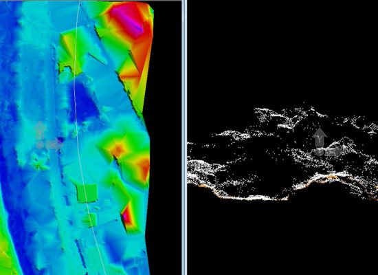
A technique to group multiple points in order to extract meaningful semantic information and generate a clean point cloud is classification. Classification removes the errors/noise from the point cloud and correctly groups the points to provide a coherent image with correct spatial extents and locations. As the mapping industry is exploding with zillion of data points, by mapping frequently, every minute parcel of earth at various scales, it has become excessively important to automate the process of classification but not compromising on the precision of it.
Drone surveyed data has its core advantage in providing datasets through Aerial Mapping that have a very high precision owing to their low flight height. Good classification techniques enhance the utility of these datasets. But automated codes used to classify these images usually are unable to do justice to the high quality data gathered through Aerial Surveys. For e.g. the usual processing algorithms are not very effective when cleaning the densely vegetated areas as algorithms are not capable to identify the correct surface area and usually mistake the agricultural field height as the base level, hence inducing error in the classification of 3D point cloud dataset. A manual post processing ensures that such errors are taken care of and rectified in order to ensure the best outputs.
GarudaUAV, going a step ahead in its endeavor, to deliver high quality data which promises precision. We classify the 3D point cloud data manually after the automated pre-process to ensure high satisfaction levels of clients. Our classification techniques promote right analytics and planning procedures ensuring development in the right direction
This design is incredible! You certainly know how to keep a reader amused. Between your wit and your videos, I was almost moved to start my own blog (well, almost…HaHa!) Great job. I really enjoyed what you had to say, and more than that, how you presented it. Too cool!
The next time I read a weblog, I hope that it doesnt disappoint me as much as this one. I mean, I know it was my choice to read, but I actually thought youd have something interesting to say. All I hear is a bunch of whining about one thing that you may repair if you werent too busy searching for attention.
Its such as you learn my mind! You seem to grasp so much about this, such as you wrote the ebook in it or something. I think that you just could do with some to pressure the message house a bit, however instead of that, that is great blog. An excellent read. I’ll definitely be back.
You can certainly see your expertise in the work you write. The world hopes for even more passionate writers like you who are not afraid to say how they believe. Always go after your heart.
Excellent post. I was checking constantly this blog and I am impressed! Extremely useful info specifically the last part 🙂 I care for such info a lot. I was seeking this particular information for a long time. Thank you and best of luck.
Your travel tips are a traveler’s goldmine! The hidden gems you uncover and the practical advice you share make exploring new places a breeze. Thank you for being a travel guide in disguise.
In accordance with my study, after a foreclosures home is sold at a bidding, it is common with the borrower to still have a remaining unpaid debt on the loan. There are many creditors who attempt to have all service fees and liens repaid by the following buyer. On the other hand, depending on certain programs, regulations, and state legal guidelines there may be some loans that are not easily settled through the switch of lending options. Therefore, the responsibility still lies on the customer that has obtained his or her property in foreclosure process. Thank you sharing your notions on this web site.
Thank you for this article. I will also like to express that it can end up being hard while you are in school and merely starting out to establish a long credit rating. There are many college students who are simply just trying to endure and have a protracted or favourable credit history are often a difficult point to have.
One more thing I would like to state is that as an alternative to trying to suit all your online degree programs on days and nights that you complete work (since the majority of people are drained when they come home), try to have most of your sessions on the weekends and only a few courses for weekdays, even if it means taking some time off your weekend break. This is beneficial because on the weekends, you will be a lot more rested plus concentrated upon school work. Thx for the different tips I have realized from your weblog.
Thanks for making me to acquire new ideas about personal computers. I also possess the belief that certain of the best ways to help keep your laptop computer in perfect condition is to use a hard plastic-type case, and also shell, that will fit over the top of the computer. These kinds of protective gear usually are model specific since they are manufactured to fit perfectly in the natural housing. You can buy them directly from the vendor, or through third party places if they are readily available for your notebook, however not all laptop may have a shell on the market. All over again, thanks for your tips.
Today, I went to the beach front with my children. I found a sea shell and gave it to my 4 year old daughter and said “You can hear the ocean if you put this to your ear.” She placed the shell to her ear and screamed. There was a hermit crab inside and it pinched her ear. She never wants to go back! LoL I know this is totally off topic but I had to tell someone!
A formidable share, I simply given this onto a colleague who was doing a little analysis on this. And he in truth bought me breakfast as a result of I found it for him.. smile. So let me reword that: Thnx for the treat! But yeah Thnkx for spending the time to discuss this, I really feel strongly about it and love studying extra on this topic. If doable, as you turn into expertise, would you mind updating your blog with more particulars? It’s extremely useful for me. Big thumb up for this weblog post!
Thanks for the points you have shared here. Another thing I would like to state is that personal computer memory requirements generally go up along with other innovations in the technologies. For instance, any time new generations of cpus are made in the market, there is certainly usually a matching increase in the type preferences of all personal computer memory as well as hard drive room. This is because the software program operated by simply these cpus will inevitably boost in power to benefit from the new know-how.
Hey would you mind sharing which blog platform you’re working with? I’m going to start my own blog in the near future but I’m having a tough time deciding between BlogEngine/Wordpress/B2evolution and Drupal. The reason I ask is because your design and style seems different then most blogs and I’m looking for something unique. P.S Apologies for being off-topic but I had to ask!
Magnificent beat ! I would like to apprentice even as you amend your website, how could i subscribe for a weblog website? The account aided me a appropriate deal. I were a little bit acquainted of this your broadcast offered brilliant transparent idea
Great items from you, man. I’ve take into accout your stuff prior to and you are just extremely excellent. I actually like what you’ve got right here, really like what you’re saying and the way in which wherein you are saying it. You make it entertaining and you still care for to keep it sensible. I can not wait to learn much more from you. That is really a wonderful web site.
I was suggested this website by my cousin. I’m not sure whether this post is written by him as no one else know such detailed about my difficulty. You’re amazing! Thanks!
What i don’t understood is actually how you’re not really much more well-liked than you may be right now. You’re very intelligent. You realize thus considerably relating to this subject, produced me personally consider it from a lot of varied angles. Its like men and women aren’t fascinated unless it抯 one thing to accomplish with Lady gaga! Your own stuffs excellent. Always maintain it up!
I don抰 even know how I ended up here, but I thought this post was great. I do not know who you are but certainly you’re going to a famous blogger if you aren’t already 😉 Cheers!
Heya i抦 for the first time here. I found this board and I find It truly useful & it helped me out much. I hope to give something back and aid others like you helped me.
We stumbled over here coming from a different page and thought I should check things out. I like what I see so now i’m following you. Look forward to looking at your web page yet again.
I like the valuable info you supply for your articles. I抣l bookmark your weblog and check again here regularly. I am somewhat sure I will be informed a lot of new stuff proper here! Best of luck for the next!
I like the valuable information you supply on your articles. I抣l bookmark your blog and test once more right here frequently. I’m quite sure I抣l be informed lots of new stuff proper right here! Good luck for the following!
Heya i am for the first time here. I found this board and I find It really useful & it helped me out a lot. I hope to give something back and aid others like you aided me.
Normally I do not learn post on blogs, but I would like to say that this write-up very pressured me to take a look at and do it! Your writing style has been amazed me. Thanks, quite great post.
Another important area is that if you are an elderly person, travel insurance intended for pensioners is something you must really think about. The elderly you are, the greater at risk you will be for allowing something undesirable happen to you while in another country. If you are definitely not covered by a few comprehensive insurance plan, you could have a few serious troubles. Thanks for discussing your advice on this website.
I do love the manner in which you have framed this situation and it does indeed offer me some fodder for consideration. However, because of what I have personally seen, I just wish as the reviews pack on that men and women remain on point and in no way get started upon a soap box of some other news of the day. Still, thank you for this superb point and while I do not concur with this in totality, I regard the standpoint.
Great paintings! That is the type of information that are meant to be shared across the web. Shame on Google for no longer positioning this put up upper! Come on over and talk over with my website . Thanks =)
According to my research, after a in foreclosure home is sold at a bidding, it is common for the borrower in order to still have a remaining unpaid debt on the loan. There are many loan merchants who try and have all service fees and liens paid back by the subsequent buyer. However, depending on a number of programs, regulations, and state legislation there may be a number of loans which aren’t easily solved through the transfer of lending options. Therefore, the obligation still rests on the debtor that has acquired his or her property foreclosed on. Thanks for sharing your notions on this website.
You really make it seem so easy with your presentation however I to find this topic to be really one thing which I feel I might never understand. It kind of feels too complex and very broad for me. I am having a look forward to your next submit, I抣l attempt to get the hang of it!
The subsequent time I learn a blog, I hope that it doesnt disappoint me as a lot as this one. I mean, I know it was my choice to read, however I actually thought youd have one thing interesting to say. All I hear is a bunch of whining about one thing that you would fix should you werent too busy looking for attention.
Thank you a bunch for sharing this with all folks you actually know what you are talking approximately! Bookmarked. Please also visit my site =). We may have a hyperlink exchange arrangement between us!
I and my buddies appeared to be reading through the nice helpful hints located on your website and so at once I had an awful suspicion I never expressed respect to the web site owner for those tips. Those men were definitely for this reason thrilled to see all of them and now have definitely been taking advantage of those things. Thanks for being very accommodating and also for going for this sort of useful subject areas most people are really wanting to know about. My very own honest regret for not saying thanks to sooner.
I believe this is among the most vital info for me. And i’m satisfied reading your article. But want to observation on some normal things, The website style is great, the articles is actually great : D. Just right process, cheers
Hi are using WordPress for your site platform? I’m new to the blog world but I’m trying to get started and create my own. Do you require any html coding knowledge to make your own blog? Any help would be greatly appreciated!
Thanks for the thoughts you are sharing on this blog site. Another thing I’d really like to say is that often getting hold of copies of your credit report in order to inspect accuracy of any detail could be the first measures you have to perform in credit restoration. You are looking to thoroughly clean your credit history from dangerous details errors that screw up your credit score.
Hi, Neat post. There’s a problem with your site in internet explorer, would test this?IE still is the market leader and a big portion of people will miss your magnificent writing due to this problem.
naturally like your web site but you have to check the spelling on several of your posts. Several of them are rife with spelling problems and I find it very bothersome to tell the truth nevertheless I will definitely come back again.
I was recommended this web site by my cousin. I’m not sure whether this post is written by him as nobody else know such detailed about my difficulty. You are amazing! Thanks!
you are truly a good webmaster. The site loading speed is incredible. It kind of feels that you are doing any unique trick. Also, The contents are masterwork. you have done a magnificent process on this subject!
Thanks for your post. I have continually noticed that many people are eager to lose weight since they wish to show up slim as well as attractive. Even so, they do not always realize that there are additional benefits just for losing weight as well. Doctors assert that obese people experience a variety of diseases that can be instantly attributed to their particular excess weight. The good thing is that people who’re overweight in addition to suffering from several diseases can help to eliminate the severity of the illnesses through losing weight. You are able to see a continuous but identifiable improvement in health if even a small amount of fat loss is realized.
An impressive share, I simply given this onto a colleague who was doing a little bit evaluation on this. And he in reality bought me breakfast because I found it for him.. smile. So let me reword that: Thnx for the treat! However yeah Thnkx for spending the time to discuss this, I really feel strongly about it and love reading more on this topic. If attainable, as you change into experience, would you thoughts updating your weblog with more particulars? It’s extremely useful for me. Big thumb up for this blog post!
Some tips i have observed in terms of laptop or computer memory is there are technical specs such as SDRAM, DDR etc, that must fit the specific features of the mother board. If the personal computer’s motherboard is reasonably current while there are no operating-system issues, changing the memory space literally normally takes under an hour or so. It’s on the list of easiest personal computer upgrade processes one can think about. Thanks for discussing your ideas.
Thanks for this informative post. It was packed with information and offered valuable knowledge. Should you be interested in how to boost your real estate business online, make sure to visit https://www.elevenviral.com for additional insights.
Thanks for the insightful article. It’s been packed with information and provided great insights. If you’re looking to learn more about how to boost your real estate business online, don’t hesitate to explore https://www.elevenviral.com for more information.
Thanks for the insightful post. It was extremely informative , and offered a lot of useful information. Should you be interested in viral real estate SEO, be sure to visit https://www.elevenviral.com to learn more.
I precisely needed to say thanks all over again. I do not know the things I would’ve worked on without the type of secrets documented by you regarding my area of interest. It became a very difficult problem in my opinion, however , considering a professional manner you processed the issue took me to weep over contentment. Now i’m grateful for this work and as well , hope that you recognize what a powerful job you’re getting into instructing many people through your webblog. I know that you haven’t come across any of us.
I’m truly impressed with your deep insights and superb way of expressing complex ideas. Your depth of knowledge shines through in every piece you write. It’s clear that you put a lot of effort into understanding your topics, and that effort is well-appreciated. Thank you for sharing such valuable insights. Continue the excellent job! https://www.elevenviral.com
I抎 must check with you here. Which isn’t one thing I normally do! I get pleasure from studying a publish that will make individuals think. Additionally, thanks for permitting me to comment!
I have seen many useful things on your internet site about computers. However, I’ve the thoughts and opinions that netbooks are still less than powerful more than enough to be a sensible choice if you usually do tasks that require many power, for example video editing and enhancing. But for internet surfing, statement processing, and quite a few other frequent computer functions they are just great, provided you do not mind the little screen size. Thanks for sharing your thinking.
Thanks for your write-up. What I want to comment on is that while looking for a good on the net electronics retail outlet, look for a website with complete information on critical factors such as the level of privacy statement, protection details, payment options, as well as other terms as well as policies. Often take time to see the help as well as FAQ areas to get a superior idea of how the shop performs, what they can do for you, and just how you can make best use of the features.
I am genuinely amazed by your keen analysis and stellar way of expressing complex ideas. The knowledge you share is evident in each paragraph. It’s evident that you put a lot of effort into understanding your topics, and this effort pays off. Thanks for providing this valuable knowledge. Continue the excellent job! https://www.elevenviral.com
It抯 truly a nice and helpful piece of info. I am happy that you shared this helpful information with us. Please stay us informed like this. Thank you for sharing.
Wonderful work! This is the type of info that should be shared around the web. Shame on Google for not positioning this post higher! Come on over and visit my web site . Thanks =)
Hi my friend! I wish to say that this post is awesome, nice written and include approximately all important infos. I抎 like to see more posts like this.
I like what you guys are up too. Such smart work and reporting! Carry on the superb works guys I抳e incorporated you guys to my blogroll. I think it’ll improve the value of my web site 🙂
Thanks for your personal marvelous posting! I certainly enjoyed reading it, you may be a great author.I will make certain to bookmark your blog and will eventually come back later in life. I want to encourage one to continue your great posts, have a nice holiday weekend!
I have been absent for some time, but now I remember why I used to love this web site. Thank you, I抣l try and check back more often. How frequently you update your web site?
Pretty part of content. I just stumbled upon your web site and in accession capital to assert that I acquire actually enjoyed account your weblog posts. Anyway I抣l be subscribing in your augment and even I success you get admission to persistently fast.
Thanks for this article. I might also like to mention that it can become hard if you are in school and starting out to initiate a long credit ranking. There are many learners who are just simply trying to make it through and have a long or beneficial credit history can occasionally be a difficult factor to have.
It抯 truly a great and useful piece of info. I am glad that you shared this helpful information with us. Please keep us informed like this. Thank you for sharing.
One thing is that while you are searching for a education loan you may find that you’ll need a cosigner. There are many situations where this is true because you should find that you do not employ a past credit standing so the loan provider will require that you’ve someone cosign the borrowed funds for you. Great post.
Pretty nice post. I just stumbled upon your blog and wished to say that I have really enjoyed browsing your blog posts. After all I will be subscribing to your rss feed and I hope you write again soon!
It抯 really a great and helpful piece of information. I am glad that you simply shared this useful information with us. Please stay us informed like this. Thank you for sharing.
Today, taking into consideration the fast lifestyle that everyone is having, credit cards have a huge demand in the economy. Persons from every area are using the credit card and people who are not using the card have prepared to apply for one in particular. Thanks for giving your ideas about credit cards.
I’m not sure exactly why but this website is loading incredibly slow for me.
Is anyone else having this problem or is it
a problem on my end? I’ll check back later and see if the problem still exists.
Wow, amazing weblog layout! How long have you been running a blog for?
you made blogging look easy. The whole look
of your site is excellent, as neatly as the content material!
Today, I went to the beach with my kids. I found a sea shell and gave it to my 4 year old daughter and said “You can hear the ocean if you put this to your ear.” She put the shell to her ear and screamed. There was a hermit crab inside and it pinched her ear. She never wants to go back! LoL I know this is entirely off topic but I had to tell someone!
Have you ever considered publishing an e-book or guest authoring on other websites?
I have a blog centered on the same information you discuss and would love to
have you share some stories/information. I know my viewers would value your work.
If you are even remotely interested, feel free to send me
an e-mail.
Thank you a bunch for sharing this with all of us you
really know what you’re talking about! Bookmarked. Kindly also visit my
site =). We may have a hyperlink alternate contract among us
A few things i have observed in terms of pc memory is there are requirements such as SDRAM, DDR and the like, that must fit in with the features of the motherboard. If the pc’s motherboard is kind of current and there are no computer OS issues, changing the ram literally normally takes under one hour. It’s one of many easiest laptop or computer upgrade processes one can think about. Thanks for discussing your ideas.
I was suggested this blog by my cousin. I am not sure whether this post is written by him as no one else know such detailed about my difficulty. You’re amazing! Thanks!

This design is incredible! You certainly know how to keep a reader amused. Between your wit and your videos, I was almost moved to start my own blog (well, almost…HaHa!) Great job. I really enjoyed what you had to say, and more than that, how you presented it. Too cool!
The next time I read a weblog, I hope that it doesnt disappoint me as much as this one. I mean, I know it was my choice to read, but I actually thought youd have something interesting to say. All I hear is a bunch of whining about one thing that you may repair if you werent too busy searching for attention.
Its such as you learn my mind! You seem to grasp so much about this, such as you wrote the ebook in it or something. I think that you just could do with some to pressure the message house a bit, however instead of that, that is great blog. An excellent read. I’ll definitely be back.
You can certainly see your expertise in the work you write. The world hopes for even more passionate writers like you who are not afraid to say how they believe. Always go after your heart.
Excellent post. I was checking constantly this blog and I am impressed! Extremely useful info specifically the last part 🙂 I care for such info a lot. I was seeking this particular information for a long time. Thank you and best of luck.
Your thoughtful comment adds so much value to the discussion. It’s clear you’ve taken the time to reflect and contribute meaningfully. Well done.
Your travel tips are a traveler’s goldmine! The hidden gems you uncover and the practical advice you share make exploring new places a breeze. Thank you for being a travel guide in disguise.
Porn
In accordance with my study, after a foreclosures home is sold at a bidding, it is common with the borrower to still have a remaining unpaid debt on the loan. There are many creditors who attempt to have all service fees and liens repaid by the following buyer. On the other hand, depending on certain programs, regulations, and state legal guidelines there may be some loans that are not easily settled through the switch of lending options. Therefore, the responsibility still lies on the customer that has obtained his or her property in foreclosure process. Thank you sharing your notions on this web site.
Thank you for this article. I will also like to express that it can end up being hard while you are in school and merely starting out to establish a long credit rating. There are many college students who are simply just trying to endure and have a protracted or favourable credit history are often a difficult point to have.
One more thing I would like to state is that as an alternative to trying to suit all your online degree programs on days and nights that you complete work (since the majority of people are drained when they come home), try to have most of your sessions on the weekends and only a few courses for weekdays, even if it means taking some time off your weekend break. This is beneficial because on the weekends, you will be a lot more rested plus concentrated upon school work. Thx for the different tips I have realized from your weblog.
Thanks for making me to acquire new ideas about personal computers. I also possess the belief that certain of the best ways to help keep your laptop computer in perfect condition is to use a hard plastic-type case, and also shell, that will fit over the top of the computer. These kinds of protective gear usually are model specific since they are manufactured to fit perfectly in the natural housing. You can buy them directly from the vendor, or through third party places if they are readily available for your notebook, however not all laptop may have a shell on the market. All over again, thanks for your tips.
Today, I went to the beach front with my children. I found a sea shell and gave it to my 4 year old daughter and said “You can hear the ocean if you put this to your ear.” She placed the shell to her ear and screamed. There was a hermit crab inside and it pinched her ear. She never wants to go back! LoL I know this is totally off topic but I had to tell someone!
A formidable share, I simply given this onto a colleague who was doing a little analysis on this. And he in truth bought me breakfast as a result of I found it for him.. smile. So let me reword that: Thnx for the treat! But yeah Thnkx for spending the time to discuss this, I really feel strongly about it and love studying extra on this topic. If doable, as you turn into expertise, would you mind updating your blog with more particulars? It’s extremely useful for me. Big thumb up for this weblog post!
Thanks for the points you have shared here. Another thing I would like to state is that personal computer memory requirements generally go up along with other innovations in the technologies. For instance, any time new generations of cpus are made in the market, there is certainly usually a matching increase in the type preferences of all personal computer memory as well as hard drive room. This is because the software program operated by simply these cpus will inevitably boost in power to benefit from the new know-how.
Hey would you mind sharing which blog platform you’re working with? I’m going to start my own blog in the near future but I’m having a tough time deciding between BlogEngine/Wordpress/B2evolution and Drupal. The reason I ask is because your design and style seems different then most blogs and I’m looking for something unique. P.S Apologies for being off-topic but I had to ask!
I appreciate, cause I found exactly what I was looking for. You’ve ended my 4 day long hunt! God Bless you man. Have a nice day. Bye
Magnificent beat ! I would like to apprentice even as you amend your website, how could i subscribe for a weblog website? The account aided me a appropriate deal. I were a little bit acquainted of this your broadcast offered brilliant transparent idea
Great items from you, man. I’ve take into accout your stuff prior to and you are just extremely excellent. I actually like what you’ve got right here, really like what you’re saying and the way in which wherein you are saying it. You make it entertaining and you still care for to keep it sensible. I can not wait to learn much more from you. That is really a wonderful web site.
I was suggested this website by my cousin. I’m not sure whether this post is written by him as no one else know such detailed about my difficulty. You’re amazing! Thanks!
What i don’t understood is actually how you’re not really much more well-liked than you may be right now. You’re very intelligent. You realize thus considerably relating to this subject, produced me personally consider it from a lot of varied angles. Its like men and women aren’t fascinated unless it抯 one thing to accomplish with Lady gaga! Your own stuffs excellent. Always maintain it up!
I don抰 even know how I ended up here, but I thought this post was great. I do not know who you are but certainly you’re going to a famous blogger if you aren’t already 😉 Cheers!
Heya i抦 for the first time here. I found this board and I find It truly useful & it helped me out much. I hope to give something back and aid others like you helped me.
We stumbled over here coming from a different page and thought I should check things out. I like what I see so now i’m following you. Look forward to looking at your web page yet again.
I like the valuable info you supply for your articles. I抣l bookmark your weblog and check again here regularly. I am somewhat sure I will be informed a lot of new stuff proper here! Best of luck for the next!
I like the valuable information you supply on your articles. I抣l bookmark your blog and test once more right here frequently. I’m quite sure I抣l be informed lots of new stuff proper right here! Good luck for the following!
Heya i am for the first time here. I found this board and I find It really useful & it helped me out a lot. I hope to give something back and aid others like you aided me.
great points altogether, you simply won a new reader. What would you suggest about your post that you made a few days ago? Any certain?
Well I definitely enjoyed studying it. This article procured by you is very useful for proper planning.
Normally I do not learn post on blogs, but I would like to say that this write-up very pressured me to take a look at and do it! Your writing style has been amazed me. Thanks, quite great post.
Another important area is that if you are an elderly person, travel insurance intended for pensioners is something you must really think about. The elderly you are, the greater at risk you will be for allowing something undesirable happen to you while in another country. If you are definitely not covered by a few comprehensive insurance plan, you could have a few serious troubles. Thanks for discussing your advice on this website.
I do love the manner in which you have framed this situation and it does indeed offer me some fodder for consideration. However, because of what I have personally seen, I just wish as the reviews pack on that men and women remain on point and in no way get started upon a soap box of some other news of the day. Still, thank you for this superb point and while I do not concur with this in totality, I regard the standpoint.
You made some decent points there. I did a search on the issue and found most people will consent with your blog.
Hello my loved one! I want to say that this post is awesome, great written and include almost all vital infos. I抎 like to look extra posts like this .
Great paintings! That is the type of information that are meant to be shared across the web. Shame on Google for no longer positioning this put up upper! Come on over and talk over with my website . Thanks =)
Thanks – Enjoyed this post, how can I make is so that I receive an email sent to me whenever you publish a new article?
According to my research, after a in foreclosure home is sold at a bidding, it is common for the borrower in order to still have a remaining unpaid debt on the loan. There are many loan merchants who try and have all service fees and liens paid back by the subsequent buyer. However, depending on a number of programs, regulations, and state legislation there may be a number of loans which aren’t easily solved through the transfer of lending options. Therefore, the obligation still rests on the debtor that has acquired his or her property foreclosed on. Thanks for sharing your notions on this website.
You really make it seem so easy with your presentation however I to find this topic to be really one thing which I feel I might never understand. It kind of feels too complex and very broad for me. I am having a look forward to your next submit, I抣l attempt to get the hang of it!
The subsequent time I learn a blog, I hope that it doesnt disappoint me as a lot as this one. I mean, I know it was my choice to read, however I actually thought youd have one thing interesting to say. All I hear is a bunch of whining about one thing that you would fix should you werent too busy looking for attention.
Thank you a bunch for sharing this with all folks you actually know what you are talking approximately! Bookmarked. Please also visit my site =). We may have a hyperlink exchange arrangement between us!
I and my buddies appeared to be reading through the nice helpful hints located on your website and so at once I had an awful suspicion I never expressed respect to the web site owner for those tips. Those men were definitely for this reason thrilled to see all of them and now have definitely been taking advantage of those things. Thanks for being very accommodating and also for going for this sort of useful subject areas most people are really wanting to know about. My very own honest regret for not saying thanks to sooner.
ダッチワイフ 社会はセックスロボットの出現について多くの懸念を抱いています
I believe this is among the most vital info for me. And i’m satisfied reading your article. But want to observation on some normal things, The website style is great, the articles is actually great : D. Just right process, cheers
Hi are using WordPress for your site platform? I’m new to the blog world but I’m trying to get started and create my own. Do you require any html coding knowledge to make your own blog? Any help would be greatly appreciated!
Thanks for the thoughts you are sharing on this blog site. Another thing I’d really like to say is that often getting hold of copies of your credit report in order to inspect accuracy of any detail could be the first measures you have to perform in credit restoration. You are looking to thoroughly clean your credit history from dangerous details errors that screw up your credit score.
Hi, Neat post. There’s a problem with your site in internet explorer, would test this?IE still is the market leader and a big portion of people will miss your magnificent writing due to this problem.
naturally like your web site but you have to check the spelling on several of your posts. Several of them are rife with spelling problems and I find it very bothersome to tell the truth nevertheless I will definitely come back again.
I was recommended this web site by my cousin. I’m not sure whether this post is written by him as nobody else know such detailed about my difficulty. You are amazing! Thanks!
you are truly a good webmaster. The site loading speed is incredible. It kind of feels that you are doing any unique trick. Also, The contents are masterwork. you have done a magnificent process on this subject!
Thanks for your post. I have continually noticed that many people are eager to lose weight since they wish to show up slim as well as attractive. Even so, they do not always realize that there are additional benefits just for losing weight as well. Doctors assert that obese people experience a variety of diseases that can be instantly attributed to their particular excess weight. The good thing is that people who’re overweight in addition to suffering from several diseases can help to eliminate the severity of the illnesses through losing weight. You are able to see a continuous but identifiable improvement in health if even a small amount of fat loss is realized.
An impressive share, I simply given this onto a colleague who was doing a little bit evaluation on this. And he in reality bought me breakfast because I found it for him.. smile. So let me reword that: Thnx for the treat! However yeah Thnkx for spending the time to discuss this, I really feel strongly about it and love reading more on this topic. If attainable, as you change into experience, would you thoughts updating your weblog with more particulars? It’s extremely useful for me. Big thumb up for this blog post!
Some tips i have observed in terms of laptop or computer memory is there are technical specs such as SDRAM, DDR etc, that must fit the specific features of the mother board. If the personal computer’s motherboard is reasonably current while there are no operating-system issues, changing the memory space literally normally takes under an hour or so. It’s on the list of easiest personal computer upgrade processes one can think about. Thanks for discussing your ideas.
I am continuously searching online for tips that can help me. Thx!
Thanks for this informative post. It was packed with information and offered valuable knowledge. Should you be interested in how to boost your real estate business online, make sure to visit https://www.elevenviral.com for additional insights.
Thanks for the insightful article. It’s been packed with information and provided great insights. If you’re looking to learn more about how to boost your real estate business online, don’t hesitate to explore https://www.elevenviral.com for more information.
Thanks for the insightful post. It was extremely informative , and offered a lot of useful information. Should you be interested in viral real estate SEO, be sure to visit https://www.elevenviral.com to learn more.
I precisely needed to say thanks all over again. I do not know the things I would’ve worked on without the type of secrets documented by you regarding my area of interest. It became a very difficult problem in my opinion, however , considering a professional manner you processed the issue took me to weep over contentment. Now i’m grateful for this work and as well , hope that you recognize what a powerful job you’re getting into instructing many people through your webblog. I know that you haven’t come across any of us.
I’m truly impressed with your deep insights and superb way of expressing complex ideas. Your depth of knowledge shines through in every piece you write. It’s clear that you put a lot of effort into understanding your topics, and that effort is well-appreciated. Thank you for sharing such valuable insights. Continue the excellent job! https://www.elevenviral.com
I抳e recently started a site, the information you offer on this website has helped me greatly. Thank you for all of your time & work.
I抎 must check with you here. Which isn’t one thing I normally do! I get pleasure from studying a publish that will make individuals think. Additionally, thanks for permitting me to comment!
I have seen many useful things on your internet site about computers. However, I’ve the thoughts and opinions that netbooks are still less than powerful more than enough to be a sensible choice if you usually do tasks that require many power, for example video editing and enhancing. But for internet surfing, statement processing, and quite a few other frequent computer functions they are just great, provided you do not mind the little screen size. Thanks for sharing your thinking.
Thanks for your write-up. What I want to comment on is that while looking for a good on the net electronics retail outlet, look for a website with complete information on critical factors such as the level of privacy statement, protection details, payment options, as well as other terms as well as policies. Often take time to see the help as well as FAQ areas to get a superior idea of how the shop performs, what they can do for you, and just how you can make best use of the features.
I am genuinely amazed by your keen analysis and stellar way of expressing complex ideas. The knowledge you share is evident in each paragraph. It’s evident that you put a lot of effort into understanding your topics, and this effort pays off. Thanks for providing this valuable knowledge. Continue the excellent job! https://www.elevenviral.com
It抯 truly a nice and helpful piece of info. I am happy that you shared this helpful information with us. Please stay us informed like this. Thank you for sharing.
Wonderful work! This is the type of info that should be shared around the web. Shame on Google for not positioning this post higher! Come on over and visit my web site . Thanks =)
Hi my friend! I wish to say that this post is awesome, nice written and include approximately all important infos. I抎 like to see more posts like this.
I like what you guys are up too. Such smart work and reporting! Carry on the superb works guys I抳e incorporated you guys to my blogroll. I think it’ll improve the value of my web site 🙂
Thanks for your personal marvelous posting! I certainly enjoyed reading it, you may be a great author.I will make certain to bookmark your blog and will eventually come back later in life. I want to encourage one to continue your great posts, have a nice holiday weekend!
Spot on with this write-up, I truly assume this web site needs much more consideration. I抣l probably be again to learn way more, thanks for that info.
Hello. remarkable job. I did not imagine this. This is a excellent story. Thanks!
I have been absent for some time, but now I remember why I used to love this web site. Thank you, I抣l try and check back more often. How frequently you update your web site?
Pretty part of content. I just stumbled upon your web site and in accession capital to assert that I acquire actually enjoyed account your weblog posts. Anyway I抣l be subscribing in your augment and even I success you get admission to persistently fast.
Thanks for this article. I might also like to mention that it can become hard if you are in school and starting out to initiate a long credit ranking. There are many learners who are just simply trying to make it through and have a long or beneficial credit history can occasionally be a difficult factor to have.
Valuable info. Lucky me I found your website by accident, and I am shocked why this accident did not happened earlier! I bookmarked it.
It抯 truly a great and useful piece of info. I am glad that you shared this helpful information with us. Please keep us informed like this. Thank you for sharing.
One thing is that while you are searching for a education loan you may find that you’ll need a cosigner. There are many situations where this is true because you should find that you do not employ a past credit standing so the loan provider will require that you’ve someone cosign the borrowed funds for you. Great post.
Pretty nice post. I just stumbled upon your blog and wished to say that I have really enjoyed browsing your blog posts. After all I will be subscribing to your rss feed and I hope you write again soon!
It抯 really a great and helpful piece of information. I am glad that you simply shared this useful information with us. Please stay us informed like this. Thank you for sharing.
Today, taking into consideration the fast lifestyle that everyone is having, credit cards have a huge demand in the economy. Persons from every area are using the credit card and people who are not using the card have prepared to apply for one in particular. Thanks for giving your ideas about credit cards.
WONDERFUL Post.thanks for share..extra wait .. ?
I’m not sure exactly why but this website is loading incredibly slow for me.
Is anyone else having this problem or is it
a problem on my end? I’ll check back later and see if the problem still exists.
Wow, amazing weblog layout! How long have you been running a blog for?
you made blogging look easy. The whole look
of your site is excellent, as neatly as the content material!
Wow! Finally I got a weblog from where I be capable of actually
get useful facts concerning my study and knowledge.
Today, I went to the beach with my kids. I found a sea shell and gave it to my 4 year old daughter and said “You can hear the ocean if you put this to your ear.” She put the shell to her ear and screamed. There was a hermit crab inside and it pinched her ear. She never wants to go back! LoL I know this is entirely off topic but I had to tell someone!
Have you ever considered publishing an e-book or guest authoring on other websites?
I have a blog centered on the same information you discuss and would love to
have you share some stories/information. I know my viewers would value your work.
If you are even remotely interested, feel free to send me
an e-mail.
Thank you a bunch for sharing this with all of us you
really know what you’re talking about! Bookmarked. Kindly also visit my
site =). We may have a hyperlink alternate contract among us
I appreciate your recommendations for email marketing software.
A few things i have observed in terms of pc memory is there are requirements such as SDRAM, DDR and the like, that must fit in with the features of the motherboard. If the pc’s motherboard is kind of current and there are no computer OS issues, changing the ram literally normally takes under one hour. It’s one of many easiest laptop or computer upgrade processes one can think about. Thanks for discussing your ideas.
As a Newbie, I am constantly searching online for articles that can help me. Thank you
I was suggested this blog by my cousin. I am not sure whether this post is written by him as no one else know such detailed about my difficulty. You’re amazing! Thanks!
https://nicesongtoyou.com/financial-portal/
아름다운스웨디시업소
Your insights on SMTP setup were very clear and concise.
You’re extraordinary!
전신스타킹
대전나이트클럽
mexican border pharmacies shipping to usa: cmq mexican pharmacy online – mexico pharmacies prescription drugs
best online pharmacies in mexico
http://cmqpharma.com/# reputable mexican pharmacies online
п»їbest mexican online pharmacies
pharmacies in mexico that ship to usa: cmq pharma – mexico pharmacy
mexican mail order pharmacies
https://cmqpharma.online/# buying from online mexican pharmacy
medicine in mexico pharmacies
Very interesting information!Perfect just what I was looking for!Raise your business
Improve your search engine rankings strategically through effective backlink acquisition.
https://indiapharmast.com/# indianpharmacy com
trusted canadian pharmacy: canadian pharmacy meds reviews – canadian pharmacy ltd
https://canadapharmast.com/# online canadian drugstore
medication from mexico pharmacy mexican online pharmacies prescription drugs mexico drug stores pharmacies
indian pharmacy paypal indian pharmacy paypal online pharmacy india
india pharmacy: buy medicines online in india – buy prescription drugs from india
Online medicine home delivery: reputable indian online pharmacy – india online pharmacy
canadian 24 hour pharmacy: onlinecanadianpharmacy 24 – canadian pharmacy world reviews
canadian pharmacy 24h com safe: canadian pharmacy in canada – canadian pharmacy meds review
http://canadapharmast.com/# canadian pharmacy near me
mexico drug stores pharmacies mexican online pharmacies prescription drugs п»їbest mexican online pharmacies
http://indiapharmast.com/# п»їlegitimate online pharmacies india
mexican rx online reputable mexican pharmacies online purple pharmacy mexico price list
mail order pharmacy india: buy prescription drugs from india – п»їlegitimate online pharmacies india
india pharmacy: top 10 online pharmacy in india – india pharmacy
medication from mexico pharmacy mexican pharmaceuticals online mexican online pharmacies prescription drugs
https://foruspharma.com/# best online pharmacies in mexico
mexican rx online: mexican online pharmacies prescription drugs – reputable mexican pharmacies online
reliable canadian pharmacy: canadian pharmacy king – precription drugs from canada
https://foruspharma.com/# buying from online mexican pharmacy
mexico drug stores pharmacies mexico drug stores pharmacies buying prescription drugs in mexico online
reputable indian online pharmacy: online shopping pharmacy india – buy medicines online in india
canada pharmacy world: canadian pharmacy 24 – canadian pharmacy uk delivery
http://indiapharmast.com/# india pharmacy
buying from online mexican pharmacy mexico pharmacy reputable mexican pharmacies online
mexico pharmacies prescription drugs: mexico drug stores pharmacies – п»їbest mexican online pharmacies
buy cipro no rx: ciprofloxacin order online – ciprofloxacin order online
http://ciprodelivery.pro/# buy cipro online without prescription
paxlovid pill paxlovid cost without insurance paxlovid covid
where can i get doxycycline: 20 doxycycline – cheap doxycycline 100mg
http://clomiddelivery.pro/# cheap clomid prices
buy ciprofloxacin over the counter: cipro for sale – п»їcipro generic
https://paxloviddelivery.pro/# Paxlovid buy online
paxlovid for sale Paxlovid over the counter п»їpaxlovid
https://clomiddelivery.pro/# where can i get generic clomid without insurance
http://clomiddelivery.pro/# where to buy generic clomid without insurance
doxycycline online uk doxycycline 100mg price in south africa pharmacy prices for doxycycline
where to get cheap clomid price: how to get cheap clomid for sale – where can i buy clomid without insurance
https://ciprodelivery.pro/# cipro
order amoxicillin online no prescription: amoxicillin price without insurance – cost of amoxicillin
http://clomiddelivery.pro/# cost of generic clomid pill
doxycycline cap tab 100mg: where can i buy doxycycline over the counter – doxycycline uk online
https://ciprodelivery.pro/# cipro for sale
buy cipro online canada buy generic ciprofloxacin ciprofloxacin generic price
https://clomiddelivery.pro/# can i order cheap clomid prices
ciprofloxacin 500 mg tablet price п»їcipro generic cipro pharmacy
https://ciprodelivery.pro/# buy ciprofloxacin over the counter
where can i buy cheap clomid pill: cheap clomid pill – cost clomid pills
https://paxloviddelivery.pro/# paxlovid price
cipro: ciprofloxacin mail online – ciprofloxacin 500mg buy online
https://doxycyclinedelivery.pro/# doxycycline canada pharmacy
paxlovid generic paxlovid price paxlovid buy
대전세븐나이트
buy cipro without rx: where to buy cipro online – ciprofloxacin 500mg buy online
http://doxycyclinedelivery.pro/# doxycycline 75 mg tab
http://doxycyclinedelivery.pro/# doxycycline 100 mg india
how much is amoxicillin prescription amoxicillin 500mg capsule buy online amoxicillin 500 mg price
how can i get generic clomid price: where to buy cheap clomid without dr prescription – order generic clomid without rx
https://ciprodelivery.pro/# ciprofloxacin 500mg buy online
paxlovid pill: paxlovid for sale – paxlovid generic
https://doxycyclinedelivery.pro/# doxycycline no prescription best prices
doxycycline over the counter nz doxycycline no script cost doxycycline tablets uk
https://doxycyclinedelivery.pro/# doxycycline over the counter
where can i buy cipro online: buy ciprofloxacin over the counter – buy ciprofloxacin
http://clomiddelivery.pro/# how can i get generic clomid for sale
amoxicillin 500mg price where can i get amoxicillin 500 mg amoxicillin 500mg capsules price
how much is amoxicillin prescription: amoxicillin 500mg capsules antibiotic – where can i buy amoxicillin online
http://paxloviddelivery.pro/# paxlovid cost without insurance
how to buy cheap clomid: order cheap clomid without dr prescription – can you get generic clomid without dr prescription
https://clomiddelivery.pro/# how to get clomid no prescription
buy cipro online without prescription ciprofloxacin generic price cipro pharmacy
https://doxycyclinedelivery.pro/# doxycycline over the counter drug
http://paxloviddelivery.pro/# paxlovid pill
paxlovid generic paxlovid pill paxlovid covid
Paxlovid buy online: paxlovid pill – п»їpaxlovid
ciprofloxacin mail online: ciprofloxacin generic price – ciprofloxacin generic price
http://amoxildelivery.pro/# buy amoxicillin online no prescription
http://amoxildelivery.pro/# price of amoxicillin without insurance
http://paxloviddelivery.pro/# paxlovid covid
ciprofloxacin 500mg buy online cipro cipro for sale
buy generic ciprofloxacin: cipro for sale – buy ciprofloxacin
http://doxycyclinedelivery.pro/# buy doxycycline us
http://doxycyclinedelivery.pro/# doxycycline 100mg capsules uk
doxycycline 100mg price uk: buy doxycycline hyclate 100mg without a rx – doxycycline for sale usa
http://amoxildelivery.pro/# how to buy amoxycillin
where can you buy amoxicillin over the counter generic amoxicillin 500mg amoxicillin 500mg pill
ciprofloxacin generic price: buy cipro cheap – cipro online no prescription in the usa